After a historically low start of the Atlantic Hurricane Season 2022, the activity has rather significantly ramped up as September rolled in. The month of August 2022 had no tropical storms or hurricane formations. Then, Danielle was the first hurricane of the Atlantic season 2022, soon followed by Earl which was moving to the east of Bermuda on Sept 4th. Fiona is the next threat for Bermuda, expected to pass very near this Friday. Our eyes are already turning to the next, potentially significant major threat for Bermuda, the Gulf of Mexico, and the United States next week.
Major hurricane Fiona crossed the Dominican Republic and Puerto Rico earlier this week, bringing significant flooding that occurred after massive rains.
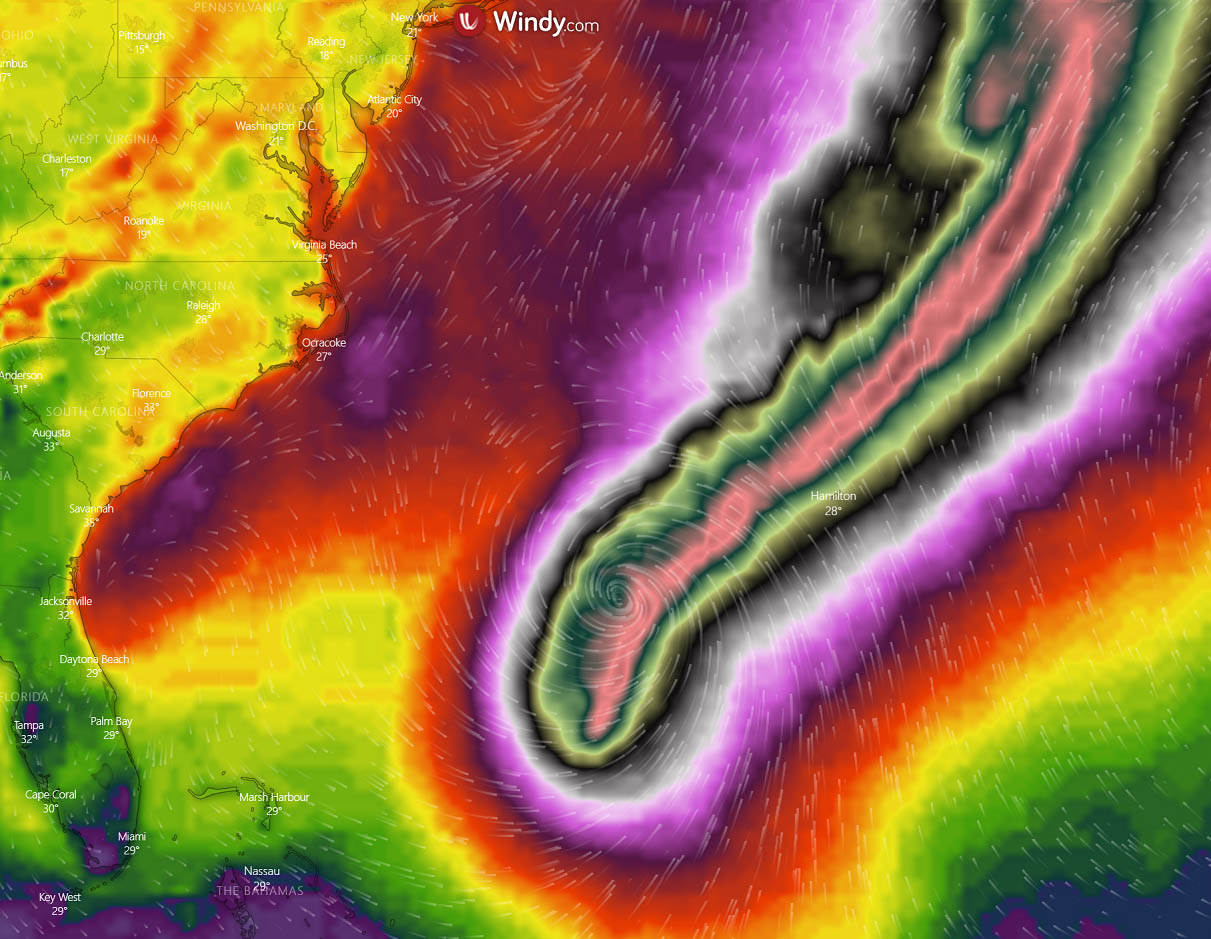
The system has taken advantage of well-above normal seawater temperatures around Bermuda, allowing it to rapidly intensify into the first major hurricane of the Atlantic Hurricane season this year. Fiona is now a Category 4 strength, maintaining the maximum sustained winds of 130 mph and central pressure around 936 mbar.
Thanks to very warm Atlantic ocean waters across the Caribbean region and the Bahamas towards Bermuda, Fiona has been strengthening also within a very favorable upper-level winds environment. Major Hurricane Fiona is forecast to pass to the west of Bermuda on Friday.
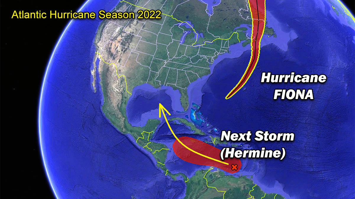
Recently, the weather models have hinted at another tropical threat, after a major tropical wave has rolled into the Western Atlantic and Caribbean region. Hermine is the next named storm that will follow and could become the first hurricane to make landfall on the United States mainland this Atlantic Hurricane Season 2022.
This year, ocean waters across the whole tropical Atlantic, the Caribbean, and the Gulf of Mexico remain very warm, even hot in some areas. Sea temperatures are anomalously warm compared to normal. Recently, these oceanic conditions are, together with the upper-level weather pattern support, resulting in increased activity as we are nearing the peak of the Atlantic Hurricane Season 2022.
As mentioned in the intro earlier, the 2022 hurricane season also had no named storms in the month of August which was only the third time since 1960 that this happens. The only two years in the past were 1961 and 1997.
However, a slow start in the tropical activity does mean nothing about how the peak months of September and October are. Which has now clearly proved, the activity has ramped up into mid-September. The overall conditions are now very favorable for the upcoming peak season weeks through late September into October ahead.
ATLANTIC HURRICANE SEASON
The global weather system is a very complex and dynamic system of chaos theory. So, weather patterns are also very different around the world. Speaking of the tropical dynamics, these are one of the more complex things to forecast, with a lot of factors that all combined. When the very perfect combination of these conditions is met, it results in the formation of tropical weather events such as tropical storms or hurricanes. Which often become a potential threat to land and property.
The Atlantic Hurricane Season 2022 has started with a very low, near record-low activity. There have only been three named storms until the end of August, followed by two more in early September. Hurricane Danielle and Earl, and then the major hurricane Fiona, currently active between Bahamas and Bermuda, moving northeast.
On average, the Atlantic hurricane season produces around 14 named tropical storms every year. There are seven of those storms than normally become hurricanes, with 3 of them also reaching major strength (a hurricane of a Category 3 or greater).

A typical Atlantic hurricane season has two peaks, with the first peak of increased activity occurring in early through mid-September. In 2022, we can see this activity has been well-aligned with the long-term statistics. Then, another, secondary boost in the tropical activity usually follows through mid-October. This can be nicely seen in the chart above.
Statistically, the general increase in tropical activity across the central Atlantic Ocean begins through early to mid-August. If we remember this year, we can see how well below-average the activity actually was. Normally, also the very first hurricane typically develops in mid-August, while we had seen the first hurricane of the Atlantic Hurricane Season 2022 – Danielle forming on Sept 2nd. For comparison, the very first hurricane forming last year was almost 45 days earlier than normal.
Major Hurricane Fiona continues to maintain its powerful Category 4 strength, gradually turning northeast towards Bermuda. Thanks to the very warm waters beneath the cyclone and also favorable upper-level conditions, Fiona had near-perfect conditions for its development. The video animation below is revealing various satellite spectrum imagery of hurricane Fiona, exposing a significant convective activity and a large symmetrical eye. The maximum sustained winds are at 130 mph (115 knots), with a very low minimum central pressure of around 936 mbar.
A hurricane development is a very specific formation in the tropical region, being strongly sensitive to atmospheric conditions that are present at a given time. When the upper-level conditions with tropical waves, such as the MJO wave, are present, those have a strong influence on the state of the atmosphere. In other words, both the extremely warm waters and great flow in the upper atmosphere combined together, allow tropical storms or hurricanes to develop.
Tropical systems normally require a very warm sea water temperature (26 °C or above). Then, very high moisture has to be present as well. Unlike the mid-latitudes cyclonic systems we know, the tropical region has no warm or cold fronts. So, the weather activity is in general a combination of showers and thunderstorms, including a larger scale pressure and wind variability. Most of this tropical variability is driven by invisible wave-like features that we find in the atmosphere around the world.
Also, a low vertical wind shear through the atmosphere is needed which normally happens when we have an MJO wave emerging from the east – we will talk about these in detail a bit further down. These waves are ejecting off the west coast of Africa, traveled into the central Atlantic then helping to develop a surface low-pressure system. Those are the early starters of the systems strengthening into tropical storms.
Note, that a tropical cyclone could quickly become a hurricane or even a major hurricane of greater than Category 3 strength when all the aforementioned conditions are near perfect. Usually, near the peak Atlantic hurricane season, a strong influence on these factors brings violent tropical systems toward the Caribbean and the United States mainland.
ATLANTIC BASIN WATERS ARE EXTREMELY WARM, INCLUDING THE CARIBBEAN, BAHAMAS, AND THE GULF OF MEXICO
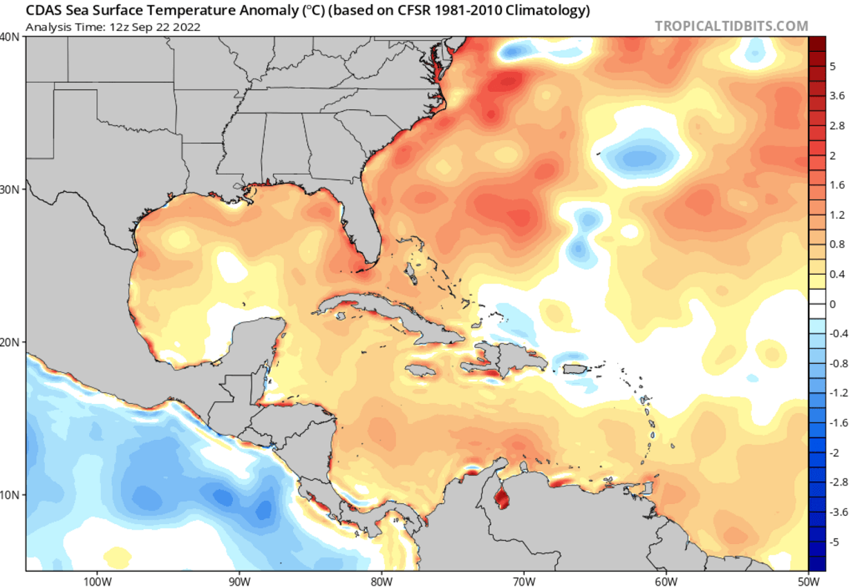
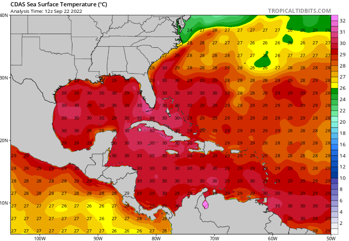
The Atlantic Ocean sea surface temperatures are statistically very warm through the summer months, as weather is more stable and warms up the waters into the low 30s °C. The recent sea surface temperature anomaly reveals that basically the whole Atlantic Basin, especially the western parts, has anomalously warmed up this hurricane season. Areas including the Caribbean and the Gulf of Mexico have their surface oceanic waters extremely warm.
As we can see from the chart below, tropical storm Fiona has taken the advantage of this significantly warmer oceanic water from the eastern Caribbean to the Bahamas. These conditions often rather quickly allow a rapid intensification of tropical cyclones, hinting why Fiona has become the first major hurricane of the Atlantic season 2022. Sea temperatures of around 2-3 °C warmer than normal are giving the system further fuel to maintain its strength while passing Bermuda on Friday.
The Atlantic Basin sea waters are, typically the warmest in the western Caribbean region and over most of the Gulf of Mexico. The sea surface temperatures are from around 28 to 30 °C in the central tropical Atlantic, they are even warmer farther west. Water surface temperatures of 31 °C or even a warmer are observed over the easter Gulf of Mexico, around Florida and Cuba. Basically, the whole Gulf of Mexico and the Caribbean are in the low 30s °C.
This is a very significant signal for the upcoming weeks when tropical waves and storms become the most frequent. Extremely warm sea waters often lead to the most intense systems, tracking closer to the Caribbean region and the United States mainland. Many tropical cyclones in the past have encountered explosive development while moving across such warm and moist fuel at the sea surface.
Actually, the very calm weather across the tropical Atlantic from July to August has allowed oceanic waters to anomalously warm-up also across the so-called MDR region. This MDR region is known as the Main Development Region, an area extending between Africa and the Caribbean Sea. Note, that the majority of the tropical system form in this region.
When the tropical waves begin ejecting off the West coast of Africa, much warmer than normal waters hint at the enhanced potential for significant tropical cyclone development. We know that convective storms are mainly fueling themselves from the very warm tropical Atlantic ocean waters. And according to the weather forecasts for the upcoming weeks, the Atlantic sea waters will remain extremely warm through the peak weeks of the Atlantic hurricane season 2022.

The present strongly anomalous sea surface temperatures are, however, quite typical when the very active Atlantic hurricane season follows around the peak weeks from mid-September through late October.
THE MJO WAVE – ATLANTIC HURRICANE SEASON ACTIVITY BOOSTER
Through mid-September, we have been tracking a pretty significant MJO wave over the western Pacific Ocean. Responsible for the development of a few powerful typhoons nearing Taiwan and Japan. Lately, a smaller wave also emerged over the central and western Atlantic, gradually moving east. Its western part resulted in several tropical waves into the eastern Atlantic, including Daniele, Earl, and hurricane Fiona.
The MJO is known as the Madden-Julian Oscillation, or short: an MJO wave. This is a very important factor for tropical activity and cyclone formation around the world. The MJO wave is the largest and the most dominant source of short-term tropical variability on Earth. This eastward-moving wave contains convective showers and thunderstorms, and typically circles the entire planet in about 30 to 60 days.

On the MJO wave chart below, provided by Michael J. Ventrice, we see the wave with filtered VP200 anomalies for the current week’s state and the forecast for a week ahead. The blue colors (cold phase) mean more favorable conditions for tropical cyclone development and the red colors (warm phase) are showing where there is a less favorable state for tropical cyclogenesis present.
As we can easily notice from the attached chart, there are favorable conditions over the western Pacific. While less favorable conditions are across the eastern Pacific Ocean, again improved towards the western Atlantic Basin. The wave sitting over the western Atlantic basin region can clearly tell us that conditions are supportive of tropical development this week and the next as well. Meaning both hurricane Fiona and the upcoming next storm Hermine will be influenced by very favorable upper-level support conditions.

The VP200 anomalies marked on the chart above indicate a Velocity Potential (VP). This is an indicator, representing the large-scale divergent flow in the upper levels of the atmosphere over the tropical region. Where the blueish colors are present, the negative VP anomalies are found. This means a divergent outflow from enhanced convective regions which, when it is combined with low shear and high sea surface temperatures, leads to tropical cyclogenesis.
The reddish colors, indeed represent the opposite in this case. Therefore, a converging upper-level flow leads to a suppressed convective activity in the region underneath. When a deep MJO wave moves over the region, it also brings a very low wind shear environment – the other important factor that helps to trigger tropical storm development.
Note that besides the MJO wave, there are also other waves that are directly related to the large-scale wave as the MJO wave. In a smaller size, we know the atmospheric Kelvin wave – is related to the tropical rainfall systems accompanied by characterized westerly and easterly wind patterns.
MAJOR HURRICANE FIONA WILL PASS VERY NEAR BERMUDA ON FRIDAY, FOR THE 2ND TIME THIS ATLANTIC SEASON 2022
Ahead of Fiona, Hurricane conditions are expected in Bermuda tonight through Friday morning. The National Hurricane Center (NHC) has issued a hurricane warning for the island.

After Bermuda, Major hurricane Fiona is expected to affect portions of Atlantic Canada as a powerful hurricane-force cyclone late Friday and Saturday. Bringing significant impacts from high winds, storm surges, and heavy rainfall. For this reason, Hurricane and Tropical Storm Watches are also in effect for much of Atlantic Canada.
Fiona will generate large swells that are expected to cause life-threatening surf and rip current conditions along much of the east coast of the United States, including the Bahamas, Bermuda, and Atlantic Canada during the next few days.
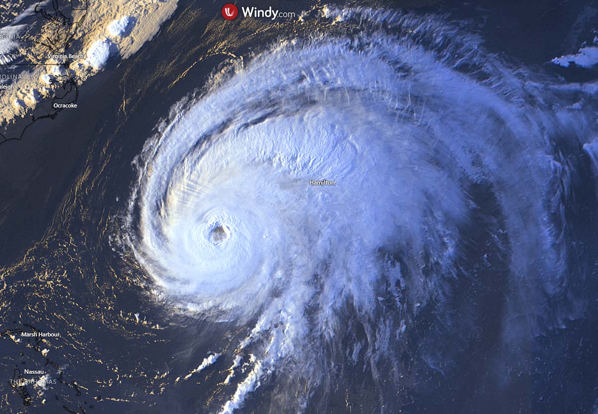
The satellite presentation of Fiona this Thursday has recovered, with the eye becoming a little better defined, and with high convective cloud tops. Meaning the storm is violent. Based on the satellite and hurricane hunters’ observations, the initial wind speed remains at 115 kt (130 mph), a solid Category 4 hurricane.
Hurricane is moving north-northeast with accelerated speed now, with Fiona making its closest approach to Bermuda overnight or early tomorrow.
Later on Friday, a vigorous mid-latitude trough that is forecast to move off the coast of the northeastern United States should cause hurricane Fiona to turn northward toward Atlantic Canada. Fiona is also forecast to grow in size as it approaches Atlantic Canada. The cyclone will pass over portions of eastern Nova Scotia by Saturday morning, and then move more slowly northward over the Gulf of St. Lawrence and portions of Newfoundland and Labrador over the weekend.
Fiona is forecast to transition into a powerful post-tropical cyclone with hurricane-force winds by Friday night. And gradually weakening later in the weekend while the system moves northward over Newfoundland and Labrador.
POTENTIAL FOR A MAJOR TROPICAL THREAT DEVELOPS OVER THE CARIBBEAN, LIKELY TO TURN TOWARDS THE GULF AND THE U.S. NEXT WEEK
Our eyes have recently turned into a significant wave that emerged into the eastern Caribbean from the western and central Atlantic this week.
Both the satellite wind data and surface observations indicate that an area of low pressure has formed in the southeastern Caribbean Sea, with the current shower and thunderstorm activity remaining rather disorganized.

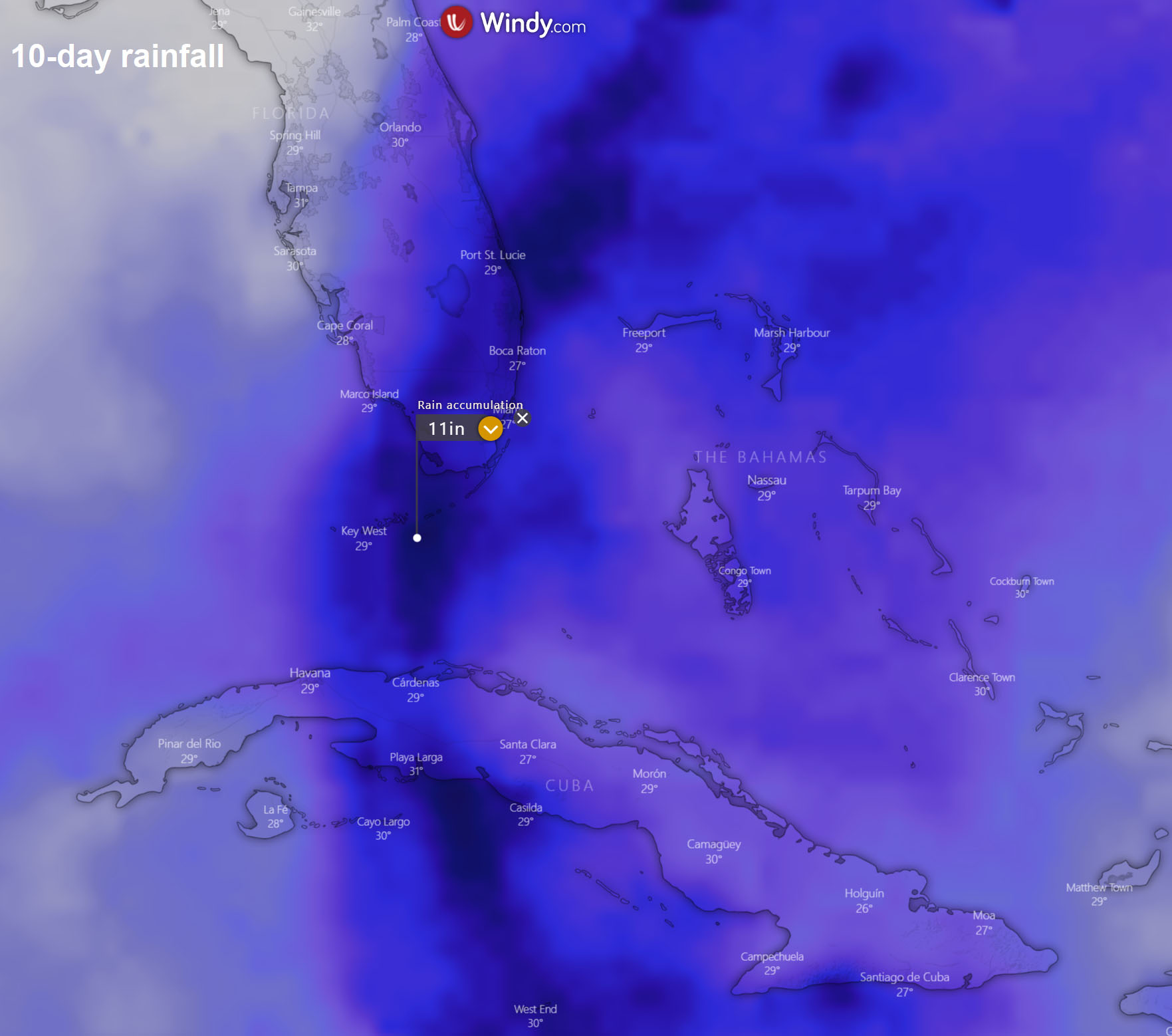
However, the overall environment is forecast to become more conducive for further development, and a tropical depression is likely to form in the next day or so. The cyclone is then forecast to move west-northwestward across the central Caribbean Sea this coming weekend where conditions are even more conducive for additional development and organizing of the system. Locally heavy rainfall and gusty winds are likely to affect the Windward Islands, northern Venezuela, and the ABC island chain through Thursday night and early Friday.
The National Hurricane Center is giving this system 80 percent to become a tropical depression over the next 48 hours, and a 90 % chance to be upgraded into a tropical storm in the next 5 days. The next name on the tropical storm list for the Atlantic hurricane season 2022 is Hermine.
It is becoming increasingly likely, the upcoming Hermine will pose the very first threat by a potentially major hurricane to the U.S. mainland this year. According to the weather models and observations of extremely warm seas and great upper-level support conditions, this system has a high chance to rapidly intensify from a tropical storm to a Category 1 or 2 hurricane in just a few days.
Sometimes from Saturday this weekend into early next week.
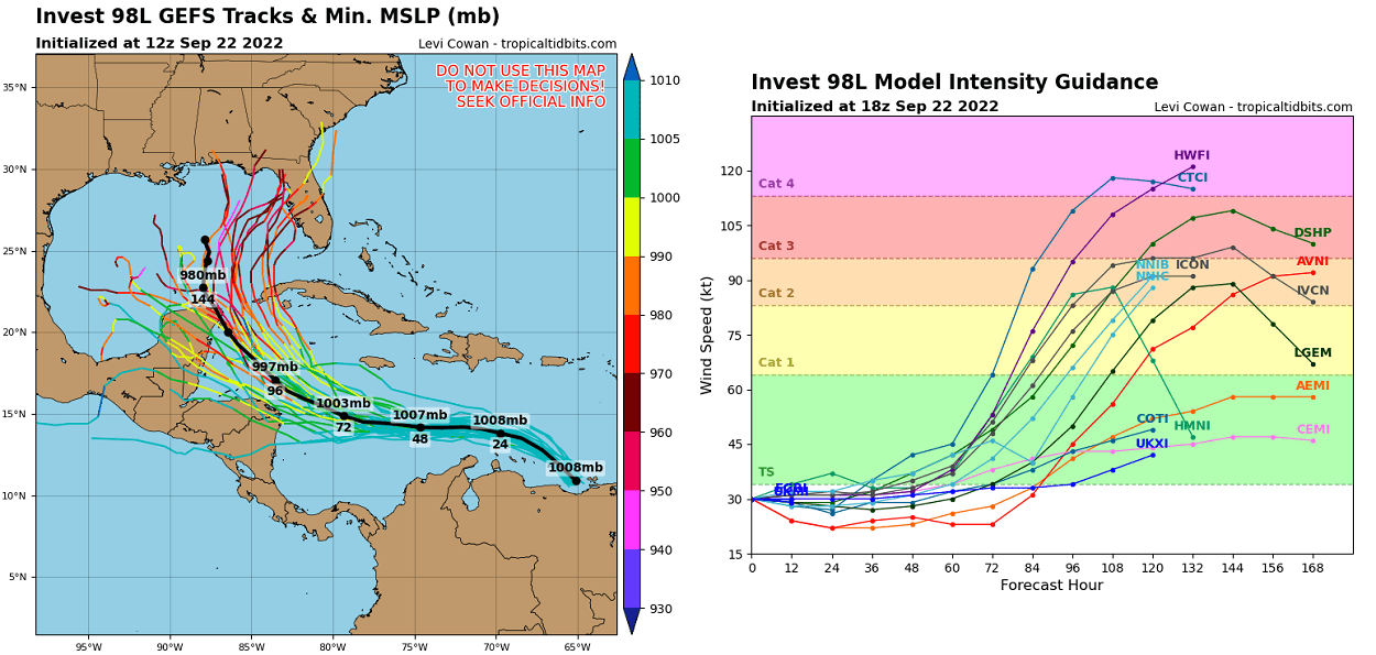
The intensity and organizing of storms moving across the Caribbean region towards the Gulf and the United States very much depend on where the center of the storm travels. If it manages to avoid the land areas of Cuba, Central America, and southeastern Mexico – the Yucatan Channel, there is a high potential for a very significant intensification while Hermine will be tracking over the open waters of the Gulf of Mexico.
This could mean the hurricane would have a higher chance to strengthen into a Category 3 hurricane or even stronger when reaching the Gulf of Mexico.
The worst-case scenario is true that the system explosively develops over the very warm waters of the northern Caribbean, arriving into the Gulf of Mexico as a major hurricane, avoiding any significant land interaction with Cuba. If this occurs, Hermine would track towards the Florida Straits and near the Florida Keys and Peninsula by mid-next week.
However, still too far in advance to be more precise on the strength and potential track, but conditions need to be very closely monitored in the upcoming days. We will keep you updated, stay tuned.
Our team will be closely monitoring any further development of Fiona and Germine and will post more updates with potential land impact next week.
SEE ALSO: