Tropical Storm Elsa made landfall in Taylor County, Florida on Wednesday, becoming the 3rd tropical cyclone to go ashore on the US mainland of Atlantic Hurricane Season 2021. Now, Elsa is accelerating towards the East Coast prompting Tropical storm warnings from the coast of South Carolina to Massachusetts.
After crossing Cuba, Elsa was flipping from tropical-storm-force to a Category 1 hurricane and back to tropical storm strength prior to the final impact on the Florida peninsula. Injured people and at least one fatality was reported while Elsa was tracking inland towards the northeast.
Several trees were down, including a tree to fall on two cars in Jacksonville, Florida, where sadly a person was killed. While in Georgia, a tornado touched down at Naval Submarine Base Kings Bay, about 40 miles north of Jacksonville, causing multiple injuries and significant damage.
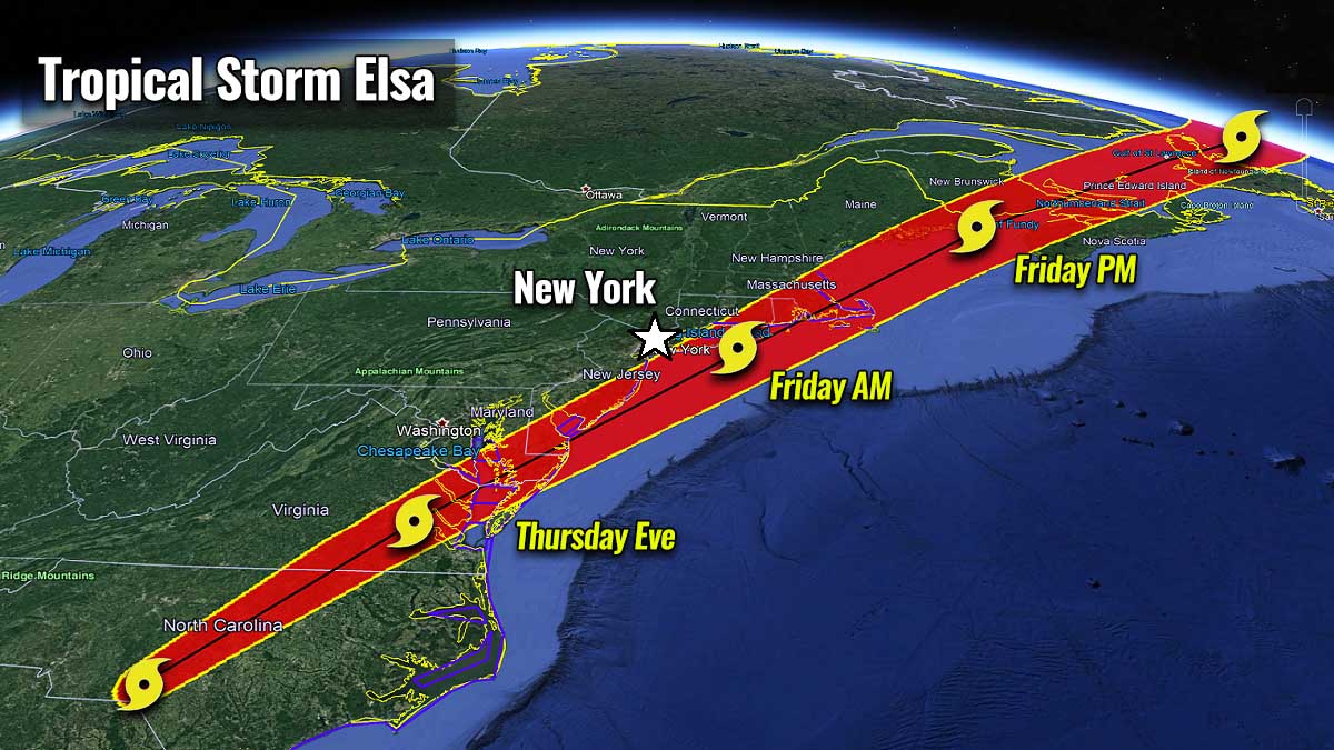
The center of Tropical Storm Elsa is moving across southern South Carolina this Thursday. The organization of the system still has compact rainbands in the eastern semicircle. Elsa will continue gradually accelerating northeast towards the mid-Atlantic states during the next 24 hours, then across southeastern New England and Atlantic Canada.
A Tropical Storm Warning is in effect for:
- South Santee River, South Carolina, to Sandy Hook, New Jersey
- Pamlico and Albemarle Sounds
- Chesapeake Bay south of North Beach and the tidal Potomac south of Cobb Island
- Delaware Bay south of Slaughter Beach
- Long Island from East Rockaway Inlet to the eastern tip along the south shore and from Port Jefferson Harbor eastward on the north shore
- New Haven, Connecticut to Merrimack River, Massachusetts including Cape Cod, Block Island, Martha’s Vineyard, and Nantucket

A Tropical Storm Warning means that tropical storm conditions are expected somewhere within the warning area.
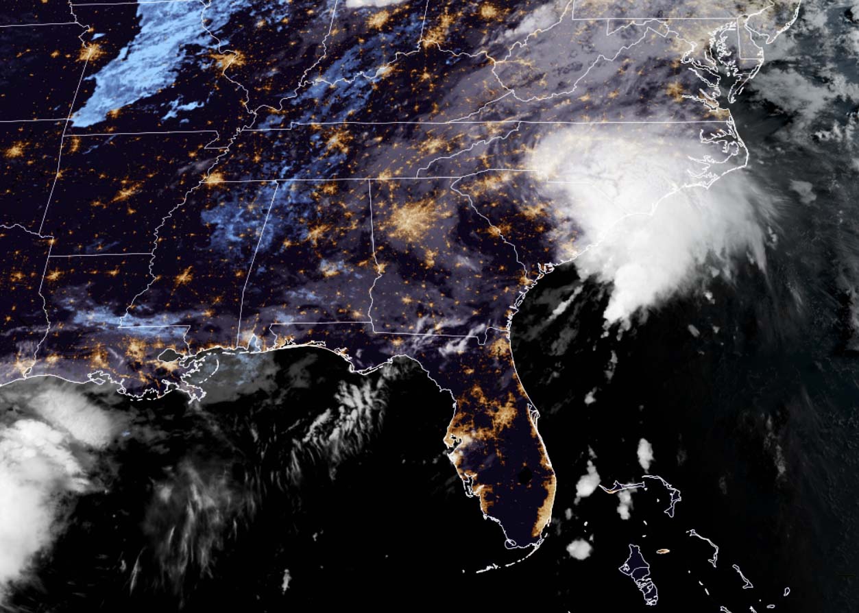
Attached below is a satellite animation of Elsa today, indicating the convective clouds remain pretty deep while it tracks across South Carolina state towards the Mid-Atlantic coast.
Today, Elsa will move over South Carolina and North Carolina, pass near the eastern mid-Atlantic states tonight, and move near or over the northeastern United States on Friday and Friday night. The system should reach and move over Atlantic Canada by Friday night and Saturday.
Elsa has the maximum sustained winds near 40 mph (65 km/h) with higher gusts. Some re-strengthening is possible tonight into Friday while the system moves close to the northeastern United States. Soon after, Elsa is forecast to become a post-tropical cyclone Friday night or Saturday.
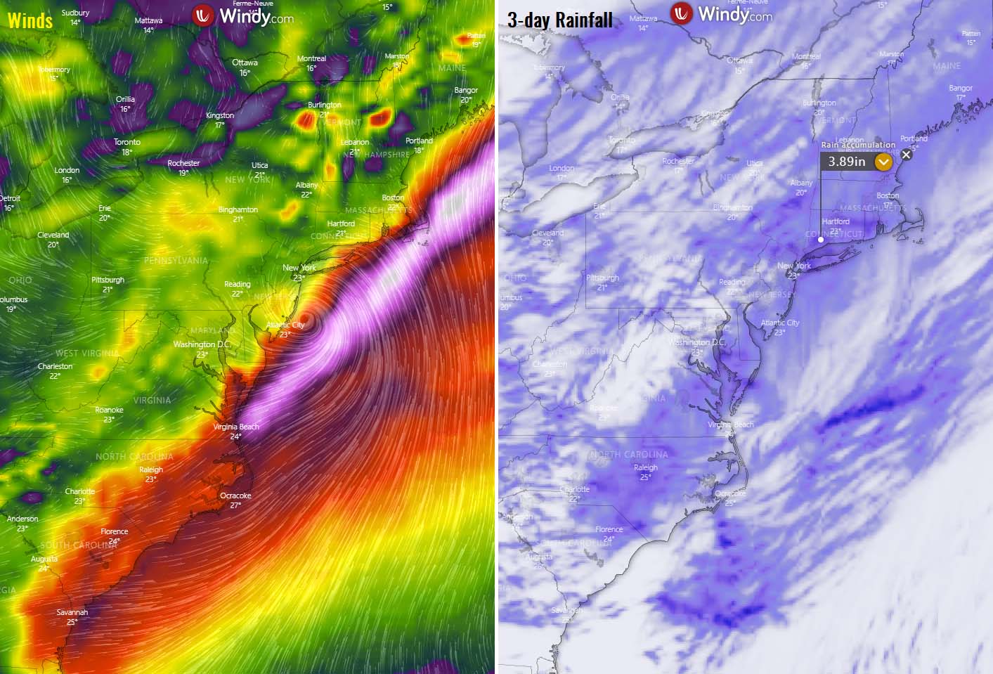
WINDS AND FLOODING THREAT ACROSS THE MID-ATLANTIC STATES AS TROPICAL STORM ELSA CONTINUES NORTHEAST
As Elsa moves across the Carolinas Thursday, heavy rainfall may result in limited flash and some urban flooding. Additionally, while Tropical Storm Elsa begins accelerating northeast, heavy rainfall from the Mid-Atlantic into New England Thursday and Friday could lead to considerable flash and urban flooding.
Tropical storm conditions are expected along portions of the coasts of Georgia and South Carolina this morning. Tropical storm conditions are also expected along the coasts of North Carolina starting later today and the mid-Atlantic by this afternoon or tonight. Tropical storm conditions are expected in portions of the southern New England states and New York by Friday.
Gale winds are expected over the portions of the New Hampshire and Maine coasts by late Friday or Friday night, and those conditions are possible over portions of Atlantic Canada Friday night and Saturday.
There are several inches of rain possible along the Mid-Atlantic states, while the majority might remain just south-southeast of the center and therefore off the coastal areas.
Another threat that often occurs during the tropical cyclone moving over land is tornadoes ahead and to the east of the tracking center of the low. There is a Tornado Watch is in effect for Eastern North Carolina and Coastal Waters through the afternoon and tonight.
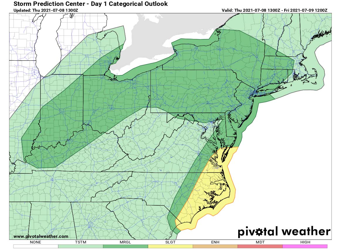
The chart above is the Storm Prediction Center’s (SPC) convective outlook for today and tonight. An SLGT (slight) risk has been issued where a diurnal increase in tornado potential associated with Tropical Storm Elsa is possible as it progresses northeast across North Carolina into mid-afternoon Thursday and tonight.
Tropical Storm Elsa will keep accelerating towards the northeast and track through the Carolinas and southeast Virginia late Wednesday into Thursday, ejecting into the Atlantic Ocean Thursday night to Friday.

Elsa should finally dissipate in the far North Atlantic over the weekend, south of Greenland.
ATLANTIC HURRICANE SEASON 2021 FINALLY TAKES A BREAK, BUT MIGHT RAMP UP AT THE END OF JULY
On average, the Atlantic hurricane season produces up to 14 named tropical storms, also 7 hurricanes, and around 3 major hurricanes (with a Category 3 or greater). The hurricane season typically has two peaks, one in early/mid-September and another one later, in mid-October.

As we head towards early August, a more significant increase of tropical cyclone activity normally begins. By mid-August, the first hurricane typically develops. But if we remember Elsa was a hurricane twice, this is around 45 days earlier than the statistical average.
The general conditions across the tropical region are now calming down, thanks to the less favorable pattern arriving with the emerging unfavorable part (suppressing convective activity) of the MJO wave from the west. Recently, a major MJO wave with favorable conditions is moving east across the tropical region of the Indian Ocean.
MJO wave is known as the Madden-Julian Oscillation and is an important factor for tropical cyclone formation. MJO is the largest and most dominant source of short-term tropical variability around the world. An eastward-moving wave of showers and thunderstorms that circles the entire planet in about 30 to 60 days.
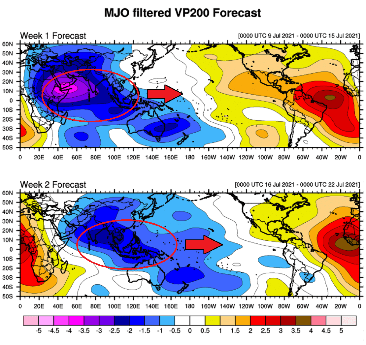
The MJO wave has two parts, enhanced rainfall on one side (wet phase), and the suppressed rainfall on the other side (dry phase). This means that there is an enhanced thunderstorm activity with a lot of rainfall on one side and reduced thunderstorm potential and drier (more stable) weather on the other side.
As we can see from the chart above, a well-defined and deep MJO wave will gradually move towards the Caribbean Region and the tropical Atlantic in about 2-3 weeks from now. This would probably happen by the end of July, so a more significant increase of activity might begin earlier this year.
A list of 21 tropical cyclone names is in use during the Atlantic hurricane season 2021. The list has started with Ana and will end with Wanda. So far, five storms – Ana, Bill, Claudette, and Danny.
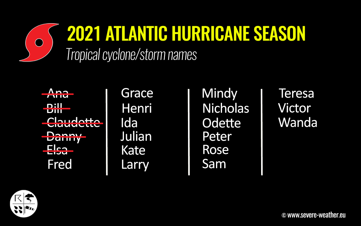
Tropical Storm Elsa was the 5th named system this year. And also the earliest 5th named tropical cyclone of the Atlantic hurricane season on record.
Very active Atlantic Hurricane Season 2021 is forecast
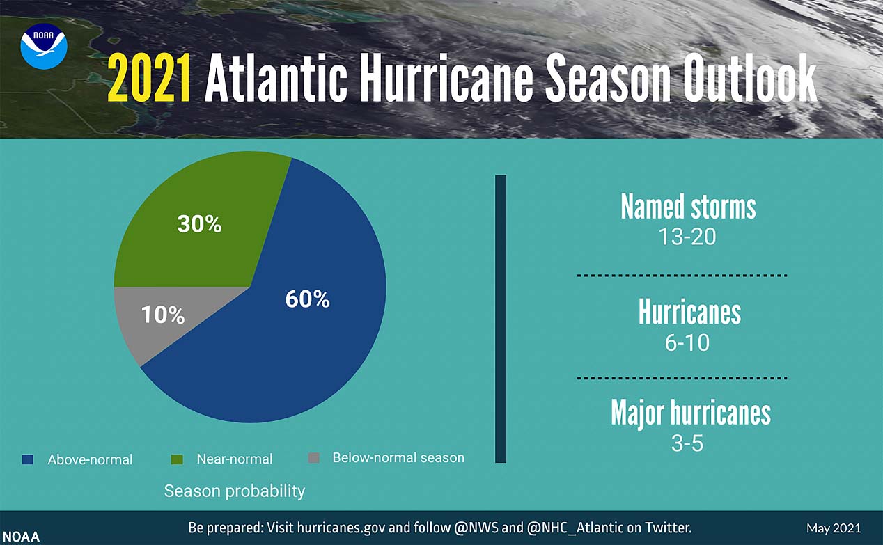
Based on the seasonal forecasts for the Atlantic Hurricane Season 2021, we can expect that the already above-normal and very active season is likely to continue through the peak months late thus summer into fall.
The NOAA’s CPC – Climate Prediction Center forecasts a 60 % chance of above-average activity this year. NOAA predicts that 13-20 named storms, 6-10 hurricanes, and also 3-5 major hurricanes could develop.
Also, the other forecasting centers are predicting similar activity within the Atlantic hurricane season 2021. The CSU – Colorado State University forecast calls for 18 named storms, the Weather Channel (TWC) is predicting 19 named storms.
But the number of storms/hurricanes is not the only thing that counts. Researchers have implemented a special metric, that we use to express the energy that was used during the tropical cyclone’s lifetime. This makes it easier to compare every tropical storm or hurricane with the other, using a so-called Accumulated Cyclone Energy (ACE) index.
ACE or ACE index is the abbreviation for the Accumulated Cyclone Energy and is used for both the Atlantic Hurricane Season and the Pacific Typhoon Season.
The expert team from the CSU is forecasting that the ACE index could be about 22 % above the normal season for the 1991-2020 period, ending at or even above 150 by the end of the Atlantic hurricane season 2021.
For the Atlantic Basin, the NOAA forecasters use 4 categories to classify storms by the ACE index:
- Extremely active – ACE index above 152.5
- Above-average – ACE index above 111
- Near-average – ACE index between 66 and 111
- Below-normal – ACE index below 66
So far, the Atlantic hurricane season 2021 has already generated an ACE of more than 10, thanks to the long-lasting tropical storm/hurricane Elsa. Elsa has brought almost 7 ACEs so far. Having an ACE of more than 10 so early in the season is the 4th most ACE by Atlantic hurricane season by July 6th over the past 60 years.
Tropical Storm Ana generated 1.01 of ACE, Bill 0.08, and Claudette 1.04 ACE. So we can see how Elsa is a pretty impressive and long-lasting system.
***The images used in this article were provided by NOAA NHC, Tropical Tidbits, and Windy.