Pattern overview through early next week, Aug 16-21, 2018)
After a rather active convective period through the first days of this week, we take a look at the pattern evolution through the rest of …
After a rather active convective period through the first days of this week, we take a look at the pattern evolution through the rest of …
Another focus for today’s convective activity across Europe will be a part of Scandinavia where severe storms with damaging winds and tornadoes are likely this …
Today, Thursday Aug 9th, a dangerous setup is shaping up for E-SE France, E Benelux, W-SW and N Germany into S Denmark. Ahead of an …
The overall blocking “heat wave pattern” across Europe is changing this week, as a more progressive pattern develops. A large deepening trough is placed across …
The current pattern reveals a strenghtening ridge across the western Europe, while a large upper low / pool of low geopotential heights is placed across …
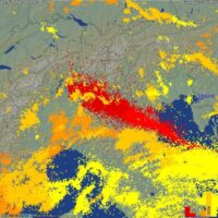
A significant outbreak of severe thunderstorms is possible today over a broad zone stretching from eastern and southern France across the Alpine region, plains of …
The weather pattern across Europe has been supporting quite a dynamic period this week. A strong ridge across NNE Europe has been holding stable conditions …
This morning’s water vapour satellite reveals an impressive upper low ejecting NE Spain. A lot of deep convection is ongoing around the core. The system …