Reports are coming of more than 130,000 homes, businesses and farms without power after Storm Ellen swept over Ireland last night. Some significant damage was left in its wake. Ellen’s impact also spread across Northern Ireland, Wales, southwestern England, and Scotland. Destructive winds up to 180 km/h were reported just off the coast of southern Ireland!
Pressure analysis
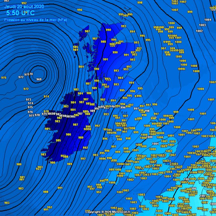
Actually, Storm Ellen was, before hitting Ireland, classified as a so-called “weather bomb” or bomb cyclone. Such cyclone is characterized by an explosive/rapid intensification led by explosive cyclogenesis process. It such systems, the air pressure drops by more than 24 millibars in the 24-hour period. Pressure dropped for nearly 30 mbar with Ellen. Attached are the pressure analysis of Ellen traveling from the Bay of Biscay into and across Ireland.
Wednesday, 21 UTC analysis
Thursday, 00 UTC analysis
Thursday, 05 UTC analysis
Storm Ellen has, later on, brought unseasonably windy weather across Wales as well.
Category 1 hurricane-force winds
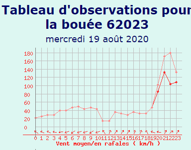
As we can see from the sustained and peak gusts wind data from the oceanic buoy #62023, the average wind speed between 8 and 9 pm local time was around 133 km/h. This is a solid Category 1 on the Saffir-Simpson hurricane scale. Peak gusts reached 180 km/h minutes later!
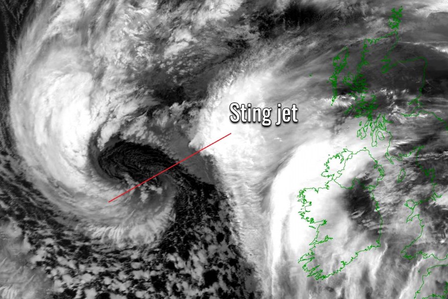
Such winds can only be possible with the sting jet wind maximum. A sting jet is a relatively localized jet of rapidly descending cold air inside a deep extratropical cyclone. Sting jets are associated with the strongest and most damaging windstorms and cause extremely severe hurricane-force winds.
What exactly is the sting jet?
A sting jet phenomenon is a narrow zone of strong winds, originating from within the mid-tropospheric cloud head of explosive cyclogenesis.
Winds are enhanced further as the jet descends, drying out and evaporating a clear path through the precipitation. The evaporative cooling leads to the air within the jet becoming much denser, causing the acceleration of the downward flow towards the tip of the cloud head when it wraps around the cyclone center.
Windspeeds in excess of 90 mph (150 km/h) are often associated with the sting jet. This cloud, hooked like a scorpion’s tail, gives the wind region its name the “sting jet”.
140-180 km/h along the southern Ireland
Peak gusts measured along the southern Irish coast and on the oceanic buoys ahead of the coast last night:
180 km/h at the Buoy #62023, Ireland
144 km/h at the Roche’s Point, Ireland
113 km/h at the Shannon Airport, Ireland
108 km/h at the Cork airport, Ireland
108 km/h at the Malin Head, Ireland
108 km/h at the Mace Head, Ireland
104 km/h at the Sherkin Island, Ireland
Peak gusts reports across Northern Ireland:
115 km/h at the Glenanne, Northern Ireland
100 km/h at the Thomastown, Northern Ireland
93 km/h at the Portuglenone, Northern Ireland
Peak gusts reports across Scotland:
151 km/h at the Cairngorm, Scotland
119 km/h at the Cairnwell, Scotland
115 km/h at the Bealach Na Ba No2, Scotland
112 km/h at the Glen Ogle, Scotland
Peak gusts reports across Wales:
128 km/h at the Capel Curig, Wales
105 km/h at the Pembrey Sands, Wales
100 km/h at the Aberdaron, Wales
Peak gusts reports across southwestern England:
109 km/h at the Buoy #62107, England
89 km/h at the Cult Rose, England
87 km/h at the Camborne, England
Sting jet visible on satellite
We can see a rather textbook feature on the satellite. Sting jet was clearly evident given the very pronounced dry intrusion being forced into the center creating violent gusts. Usually, a cloud signature like a scorpion tail is seen.
Very windy today, with bright or sunny spells & scattered heavy showers, merging to give longer spells of rain at times, with risk of thundery downpours & localised flooding. Max temps 16 to 19°C, in strong & gusty southerly winds, reaching gale force at times in coastal areas. pic.twitter.com/jtsNtPqDVn
— Met Éireann (@MetEireann) August 20, 2020
Radar imagery revealed an impressive passage of the storm Ellen and its directly across Ireland, curving towards the Atlantic in the second half of the night.
#StormEllen broke Mean Wind Speed (111 km/h) & MSL Pressure (966.4 hPa) records for August.
As our climate continues to change we expect more weather records to be broken
Met Éireann Radar images show the passage of Storm Ellen over Irelandhttps://t.co/U8dRywvyWo pic.twitter.com/iPHqrW2piu— Met Éireann (@MetEireann) August 20, 2020
Reports during storm and aftermath
#StormEllen making her presence felt – Kinsale, County Cork. 22:25 pic.twitter.com/TM7dhpoLxL
— Terry Brennan (@terrybrennan82) August 19, 2020
https://twitter.com/catboy1970/status/1296405597001326592
https://twitter.com/ZaraGreyhound/status/1296245074515447810
https://twitter.com/RawazOsman2/status/1296433876324229120
Severe winds and flooding warnings remain in effect today and tonight. Threats should gradually vanish on Friday as the main extratropical depression vanishes while drifting northeast. Stay alert!
See also:


