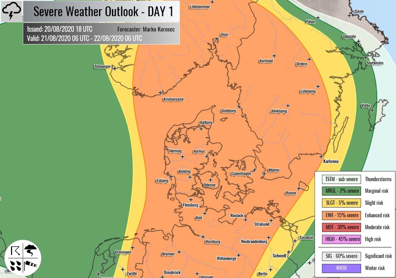
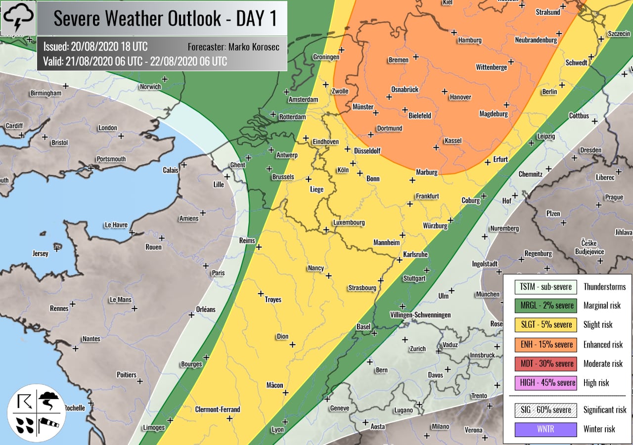
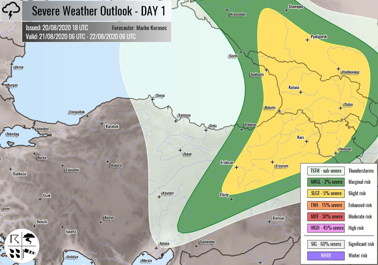
Severe weather outlook – forecast across Europe. This forecast features areas of organized severe weather with risk levels and severe weather threats across the European continent.
SEVERE WEATHER OUTLOOK – DAY 1
Valid: 21/08/2020 06 UTC – 22/08/2020 06 UTC
Issued by: Severe Weather Europe
Forecaster: Marko Korošec
SUMMARY
A large extratropical storm finally begins weakening while drifting towards the northeast. A surface cold front will continue east across western Europe and southern Scandinavia on Friday. Upper ridge continues to strengthen ahead of the Atlantic depression. A pronounced upper short-wave sits over the eastern Black Sea region.
Overview of the risk areas across Europe
SYNOPTIC OVERVIEW
A large and deep upper trough/low over North Atlantic will expand into western Europe with a powerful surface extratropical depression. Another low is moving across the Black Sea region. In between, an upper-level ridge is building up from the south across central into northern Europe. At the surface, a cold front is extending from the North Sea across Benelux towards Iberia. Occluded fronts are moving across the UK and Ireland.
FORECAST DISCUSSION
+++ Germany, Denmark, Sweden and Norway +++
ENH/SLGT risks have been issued for northern and western Germany, eastern Netherlands and Belgium, Denmark, southern Sweden and southern Norway with a threat for severe storms, capable of producing severe damaging winds, torrential rainfall, tornadoes, and marginal hail.
A large North Atlantic extratropical cyclone is in its weakening phase while drifting towards northern Europe. Strongly sheared environment spreads into the forecast area, coupled with some marginal instability.
Scattered showers and thunderstorms are expected within maritime airmass. However, isolated organized storms including supercells are likely to occur as well. Those could produce severe winds and torrential rainfall. Locally, intense rain squalls are expected as well. Given the relatively high moisture and strong shear in place.
Enhanced low-level shear and helicity around Denmark and southern Sweden could support storms with tornadoes.
Only isolated storms are possible within the SLGT risk, surrounding the ENH risk. Supercells could bring severe winds, torrential rainfall but only some marginal hail as instability is limited.
+++ Germany, Benelux, France and Spain +++
SLGT risk has been issued from western Germany into central France and north-central Spain with a threat for isolated severe storms, capable of producing marginal hail, severe winds, and torrential rainfall.
Storms will mainly form along the moving surface cold front. Marginal instability but quite strong shear should not be too supportive for strongly organized storms.
+++ northeast Turkey, Georgia and Armenia +++
SLGT risk has been issued for northeastern Turkey into Georgia and northern Armenia with a threat for severe storms, capable of producing severe winds, large hail, and torrential rainfall.
Under a rather deep short-wave trough, moderate instability and shear are coupled together across the Black Sea region into Georgia. A few isolated supercells are likely to form, producing large hail and severe winds as the primary threats.
MRGL risk has been issued for areas surrounding the SLGT risk, extending into eastern Ukraine where isolated severe storms are also possible. Low shear but some good instability could bring some torrential rainfall and marginal hail with the strongest storms.
+++ other areas +++
SLGT risk has been issued for northeastern Algeria with a threat for isolated severe storms, capable of producing severe winds, large hail, and torrential rainfall.
TSTM risk areas have been placed across the northern Scandinavia, the Alps, and Belarus with a threat for daytime driven storms. Limited shear is present, so the storms should remain sub-severe.
Follow & report severe weather events on our Facebook page:
Severe Weather Europe Facebook page
Understanding Severe Weather Outlook
Severe Weather Outlook features areas of organized severe weather with risk levels and severe weather threats. Risk levels are divided into seven categories:
TSTM – Thunderstorms
MRGL – Marginal risk
SLGT – Slight risk
ENH – Enhanced risk
MDT – Moderate risk
HIGH – High risk
SIG – Significant risk
WNTR – Winter risk
Risk categories stand for the coverage and intensity of organized severe weather. Those could include supercells, squall lines, mesoscale convective systems, wind storms, flooding, snowstorms, or ice storms.
Severe weather threats include:
- large hail (of at least 2 cm in diameter)
- Tornadoes (including waterspouts)
- Wind gusts (convective or non-convective) above 25 m/s (or above 90 km/h)
- Torrential convective precipitation / Flash floods
- Excessive rainfall (100 mm within 12 hours) / snowfall (50 cm within 12 hours)
Extremely severe weather threats include:
- Large hail (of at least 5 cm in diameter)
- Tornadoes of F2 intensity or stronger
- Wind gusts (convective or non-convective) above 33 m/s (or above 119 km/h) or 12 Bft
- Torrential convective precipitation / Flash floods
- Excessive rainfall (150 mm within 12 hours or above ) / snowfall (above 100 cm within 24 hours)
Categories in the forecast represent the chance of severe weather occurring within a 40 km radius from a location. The used level is based on the conversion table of probabilistic risk into the outlook categories. A threat level is upgraded into a higher category if probabilities meet the threshold criteria for the specific threat (e.g. tornado, wind, hail, or rainfall threat).
Each individual threat area includes a detailed forecast map and discussion on the potential of severe weather threats.
Read more: Explanations for abbreviations (TSTM, SLGT, ENH, etc.)


