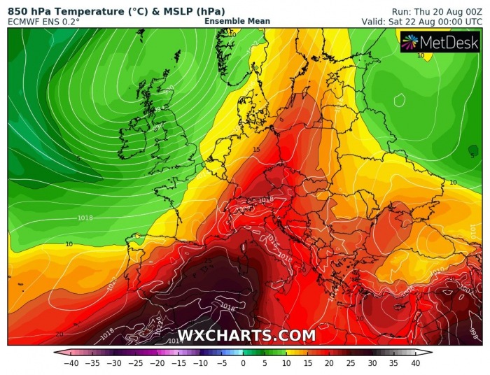
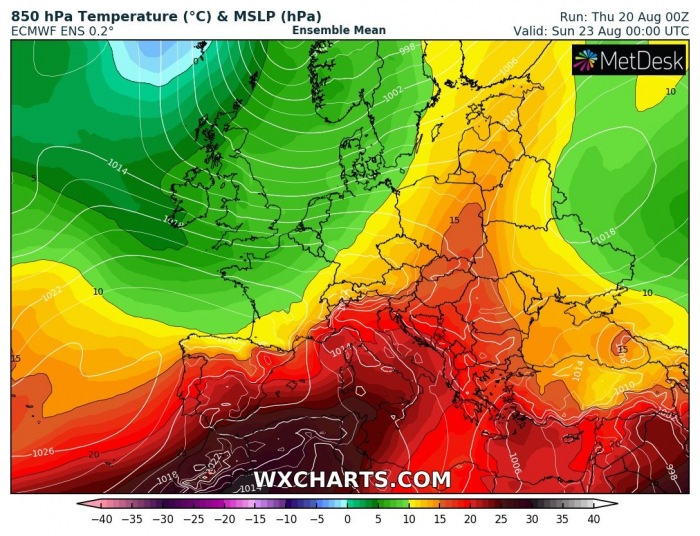
Ahead of an unseasonably strong North Atlantic extratropical storm Ellen, a strong but relatively short heatwave develops across continental Europe. Powerful southwesterly winds should deliver late August summer heat into eastern and central Europe. Temperatures should locally climb into the upper 30s again.
Storm Ellen crosses Ireland and UK
Violent storm has brought quite a wild and windy past 24 hours over Ireland, Wales, and southwestern England. The system was a part of the main North Atlantic depression which has now matured over western Europe. While storm Ellen is decaying and moving over Scotland today, the main circulation has a powerful jet stream rounding it. At the same time, upper-level ridging is building up from southern into central Europe.
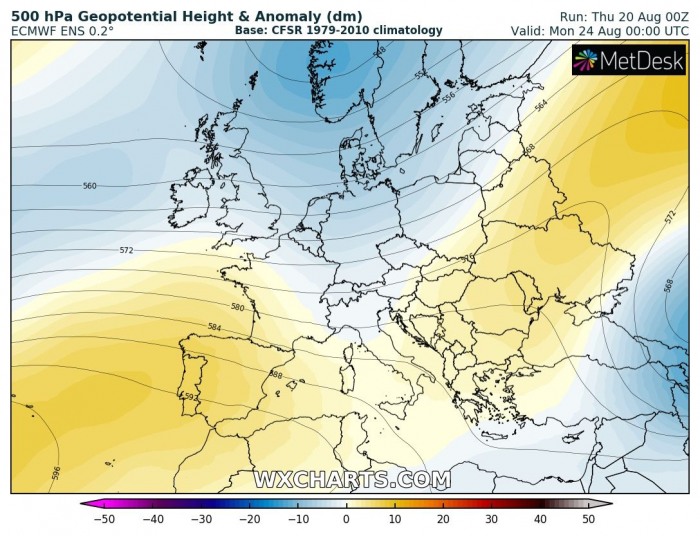
After today, a gradual weakening of the depression is expected while the system will continue towards the northeast. This will cause the upper ridge to additionally strengthen over Europe, building up an omega blocking pattern across the continent. Therefore, stable weather is expected to build up beneath the ridge.
However, on Saturday, the main weakening trough moves into northern Europe. The ridge becomes elongated and spreads into eastern Europe.
Warm advection into Europe
Thursday
Today (Thursday), the warm advection is particularly strong across the western and southwestern Europe, as a powerful southwesterly jet stream is pushing warm air mass from the Iberian peninsula and the Mediterranean. It will be extremely warm day over Algeria. But a broad channel of very warm air mass is also spreading across France into Benelux and central Europe.
Friday
On Friday, the northeast progression of the Atlantic depression pushes the jet further east. The warm advection from the Mediterranean strengthens into the Alpine region and also across Germany. Again, extremely hot weather with close to 50 °C in Algeria under nearly 30 °C at 850 mbar level.
Saturday
On Saturday, a surface cold front associated with the Atlantic low will push generally east towards central Europe. The cooler air mass will spread in its wake, and result in the spread of the hot air mass into the Balkan peninsula. It will remain very hot and stable over the Mediterranean.
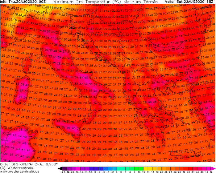
Maximum temperatures above 35 °C
Stable and strong mid-level warm advection should result in a strong heatwave from France through Thursday, spreading into Germany and around the Alps on Friday. Temperatures should reach between +33 and +38 °C in many regions.
While the cold front brings a refreshment across western and central Europe, heatwave persists across southern Europe over the weekend. Temperatures should remain between +35 and +40 °C across Italy and the southern Balkan peninsula.
A cold front arrives on Sunday
The Atlantic front will push east on Saturday. This should create a decent temperature gradient along the frontal boundary. A short-wave trough will develop into central Europe and increase the chances of severe weather developing on both Saturday and Sunday – more on this in the coming days.
Increasing moisture should result in rising instability along the front. With some shear left with the weakening jet stream, conditions will become conducive for organized storms over the weekend.
Recap: As storm Ellen and weakening North Atlantic depression move from western to northern Europe, heatwave development across continental Europe is expected. A short, but relatively strong heatwave develops across southern, central, and partly also western Europe. Over the weekend, a cold front brings cooler air mass and severe storms across central Europe.
See also:


