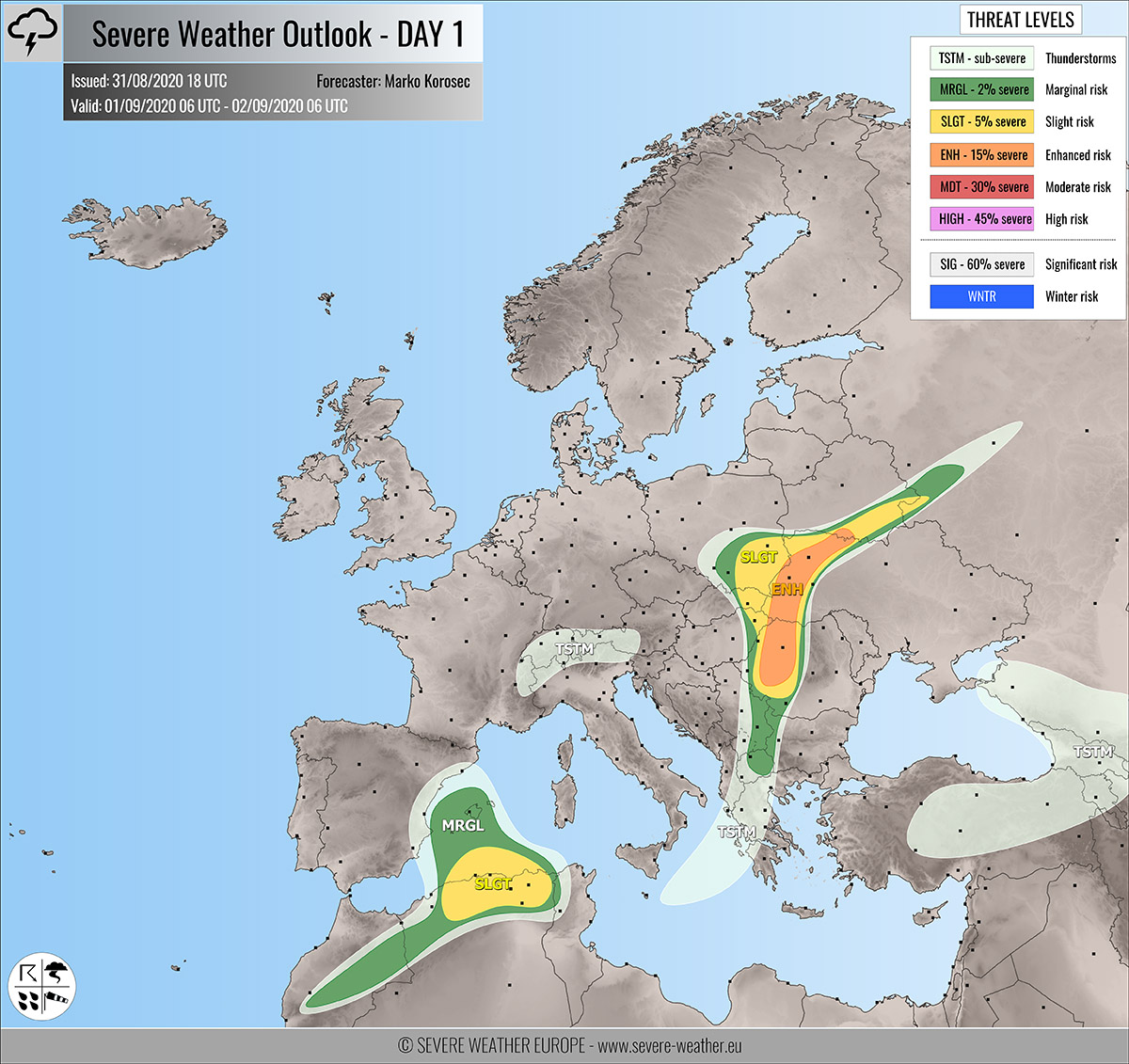
Severe weather outlook – forecast across Europe. This forecast features areas of organized severe weather with risk levels and severe weather threats across the European continent.
SEVERE WEATHER OUTLOOK – DAY 1
Valid: 01/09/2020 06 UTC – 02/09/2020 06 UTC
Issued by: Severe Weather Europe
Forecaster: Marko Korošec
SUMMARY
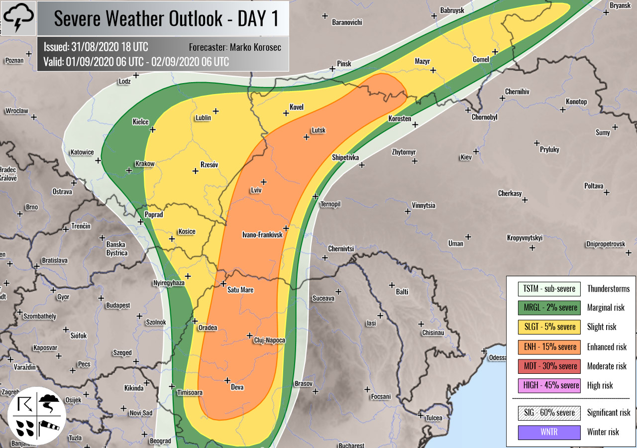
Severe storms are likely across parts of Hungary, Romania, Ukraine, and Belarus along with the frontal system on Tuesday. Supercells could result in some large hail, severe winds, and torrential/excessive rainfall events.
Overview of the risk areas across Europe
SYNOPTIC OVERVIEW
An upper ridge is strengthening over southeastern, western, and northern Europe. To its south, a large upper low is rotating over central Europe. Another short-wave trough deepens over the Iberian peninsula, entering the western Mediterranean. At the surface, a frontal system continues across the central Balkans towards the northeast.
FORECAST DISCUSSION
+++ Poland, Slovakia, Hungary, Belarus, Ukraine and Romania +++

ENH/SLGT risks have been issued for southeastern Poland, eastern Slovakia, southeast Belarus, western Ukraine, eastern Hungary, and western Romania with a threat for severe storms capable of producing severe winds, torrential/excessive rainfall, and large hail.
Rather widespread storms are likely to develop along with the northeastwards moving frontal system. Strong shear coupled with moderate CAPE should favor organized storms, including supercells. Large hail, severe winds, and torrential rainfall are possible.
Storms should have a tendency to merge into larger clusters through the late afternoon and evening hours near the moving front.
+++ southwest Mediterranean and Algeria +++
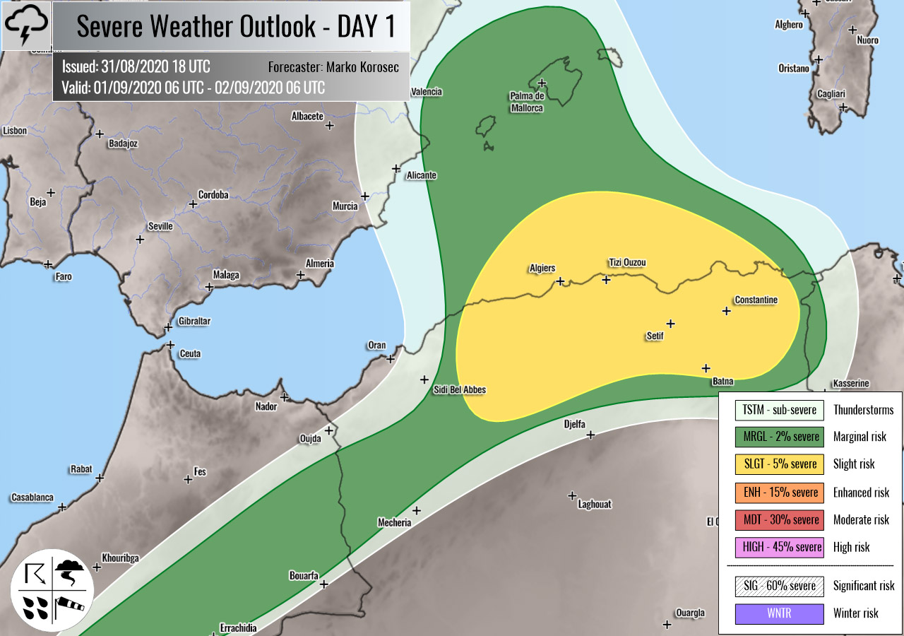
SLGT/MRGL risks have been issued for the southwestern Mediterranean into northern Algeria with a threat for severe storms, capable of producing severe winds, torrential rainfall, and large hail.
With the new upper wave/low coming from the west, instability builds up over the western Mediterranean. At the same time, shear increases. Conditions could support some isolated to scattered severe storms to form across the SLGT risk area. Those could produce severe winds and large hail.
+++ other areas +++
TSTM risks have been issued for the Alps, the Ionian Sea, east-central Turkey, Georgia, and southwestern Russia with a threat for daytime driven storms. Limited shear is present, so the storms should remain sub-severe.
Follow & report severe weather events on our Facebook page:
Severe Weather Europe Facebook page
Understanding Severe Weather Outlook
Severe Weather Outlook features areas of organized severe weather with risk levels and severe weather threats. Risk levels are divided into seven categories:
TSTM – Thunderstorms
MRGL – Marginal risk
SLGT – Slight risk
ENH – Enhanced risk
MDT – Moderate risk
HIGH – High risk
SIG – Significant risk
WNTR – Winter risk
Risk categories stand for the coverage and intensity of organized severe weather. Those could include supercells, squall lines, mesoscale convective systems, wind storms, flooding, snowstorms, or ice storms.
Severe weather threats include:
- large hail (of at least 2 cm in diameter)
- Tornadoes (including waterspouts)
- Wind gusts (convective or non-convective) above 25 m/s (or above 90 km/h)
- Torrential convective precipitation / Flash floods
- Excessive rainfall (100 mm within 12 hours) / snowfall (50 cm within 12 hours)
Extremely severe weather threats include:
- Large hail (of at least 5 cm in diameter)
- Tornadoes of F2 intensity or stronger
- Wind gusts (convective or non-convective) above 33 m/s (or above 119 km/h) or 12 Bft
- Torrential convective precipitation / Flash floods
- Excessive rainfall (150 mm within 12 hours or above ) / snowfall (above 100 cm within 24 hours)
Categories in the forecast represent the chance of severe weather occurring within a 40 km radius from a location. The used level is based on the conversion table of probabilistic risk into the outlook categories. A threat level is upgraded into a higher category if probabilities meet the threshold criteria for the specific threat (e.g. tornado, wind, hail, or rainfall threat).
Each individual threat area includes a detailed forecast map and discussion on the potential of severe weather threats.
Read more: Explanations for abbreviations (TSTM, SLGT, ENH, etc.)

