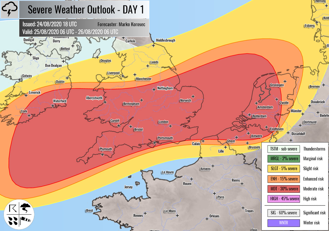
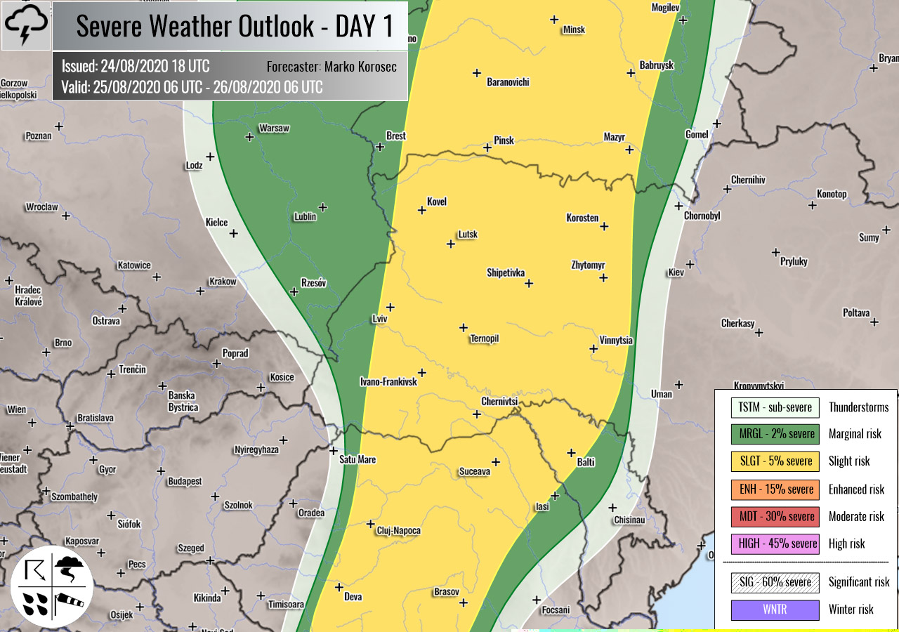
Severe weather outlook – forecast across Europe. This forecast features areas of organized severe weather with risk levels and severe weather threats across the European continent.
SEVERE WEATHER OUTLOOK – DAY 1
Valid: 25/08/2020 06 UTC – 26/08/2020 06 UTC
Issued by: Severe Weather Europe
Forecaster: Marko Korošec
SUMMARY
Severe winds are expected with the deep surface low moving across UK and Ireland into the North Sea. Isolated severe storms with large hail, torrential rainfall, and severe winds are possible along the cold front from Belarus towards Romania and also over southern Balkans and Italy on Tuesday.
Overview of the risk areas across Europe
SYNOPTIC OVERVIEW
An upper trough over northern Europe is weakening while moving east. Another trough/low develops over western Europe with an associated surface frontal system pushed from the UK and Ireland towards Benelux and the North Sea. A short wave trough and a weakening surface cold front is placed across eastern Europe and the Balkans.
FORECAST DISCUSSION
+++ Ireland, Wales, England, France, Belgium, the Netherlands, Germany and Denmark +++
MDT risk has been issued for southeastern Ireland into Wales and across southern England towards northern Belgium and the Netherlands with a threat for severe damaging winds, and heavy rainfall.
Associated with a strong surface low and frontal system, widespread severe winds are expected to push across the risk area. Peak gusts could locally reach up to around 120 km/h. Some isolated convective squalls are possible in the wake of the low over Ireland and Northern Ireland towards Wales and northern England.
Activity will gradually spread east-northeast from the early Tuesday until Wednesday morning, reaching Benelux and the North Sea. Heavy rain squalls are possible with the most robust storms, while severe damaging winds will remain the primary threat.
ENH/SLGT risks have been issued for areas surrounding the MDT risk across Ireland, England, extreme northeast France, Belgium, northwestern Germany, and Denmark with a more isolated threat for severe winds, and heavy rainfall.
+++ Italy and southern Balkans +++
SLGT/MRGL risks have been issued for southern Italy and across the south-central Balkan peninsula with a threat for severe storms, capable of producing severe winds, large hail, and torrential rainfall.
Associated with the weakening short-wave trough and surface front, isolated storms are expected to form. A moderate shear but marginal instability should only support a few isolated organized storms, possibly supercells. Those could result in some large hail and severe wind events.
+++ Romania, Moldova, Ukraine and Belarus +++
SLGT risk has been issued for parts of Romania across northern Moldova into western Ukraine and Belarus for isolated severe storms, capable of producing severe winds and marginally large hail.
Along the weakening cold front, a few better-organized storms are possible. Although they should mainly be multicell storms, a supercell or two are possible as well. Activity will decay towards the evening hours.
+++ other areas +++
TSTM risks have been issued for eastern Spain into northern Morocco and northwestern Algeria with a threat for daytime driven storms. Limited shear is present, so the storms should remain sub-severe.
Follow & report severe weather events on our Facebook page:
Severe Weather Europe Facebook page
Understanding Severe Weather Outlook
Severe Weather Outlook features areas of organized severe weather with risk levels and severe weather threats. Risk levels are divided into seven categories:
TSTM – Thunderstorms
MRGL – Marginal risk
SLGT – Slight risk
ENH – Enhanced risk
MDT – Moderate risk
HIGH – High risk
SIG – Significant risk
WNTR – Winter risk
Risk categories stand for the coverage and intensity of organized severe weather. Those could include supercells, squall lines, mesoscale convective systems, wind storms, flooding, snowstorms, or ice storms.
Severe weather threats include:
- large hail (of at least 2 cm in diameter)
- Tornadoes (including waterspouts)
- Wind gusts (convective or non-convective) above 25 m/s (or above 90 km/h)
- Torrential convective precipitation / Flash floods
- Excessive rainfall (100 mm within 12 hours) / snowfall (50 cm within 12 hours)
Extremely severe weather threats include:
- Large hail (of at least 5 cm in diameter)
- Tornadoes of F2 intensity or stronger
- Wind gusts (convective or non-convective) above 33 m/s (or above 119 km/h) or 12 Bft
- Torrential convective precipitation / Flash floods
- Excessive rainfall (150 mm within 12 hours or above ) / snowfall (above 100 cm within 24 hours)
Categories in the forecast represent the chance of severe weather occurring within a 40 km radius from a location. The used level is based on the conversion table of probabilistic risk into the outlook categories. A threat level is upgraded into a higher category if probabilities meet the threshold criteria for the specific threat (e.g. tornado, wind, hail, or rainfall threat).
Each individual threat area includes a detailed forecast map and discussion on the potential of severe weather threats.
Read more: Explanations for abbreviations (TSTM, SLGT, ENH, etc.)


