Another volcano in Iceland is on an increased alert after an earthquake swarm and ground movement. In addition, the available data shows that magma is accumulating under the volcano, steadily increasing the risk of an eruption in the near future.
But as you will see, there is more than one volcano ready to erupt in Iceland. Moreover, there is a known history of widespread effects on Europe and across the Northern Hemisphere from Icelandic eruptions. For this reason, each event is being monitored closely and taken seriously.

FIRE MEETS ICE
Iceland is a volcanic island in the North Atlantic and one of the most active volcanic regions in the world. In its history, it produced significant eruptions with powerful impacts on Europe, North America, and the entire Northern Hemisphere.
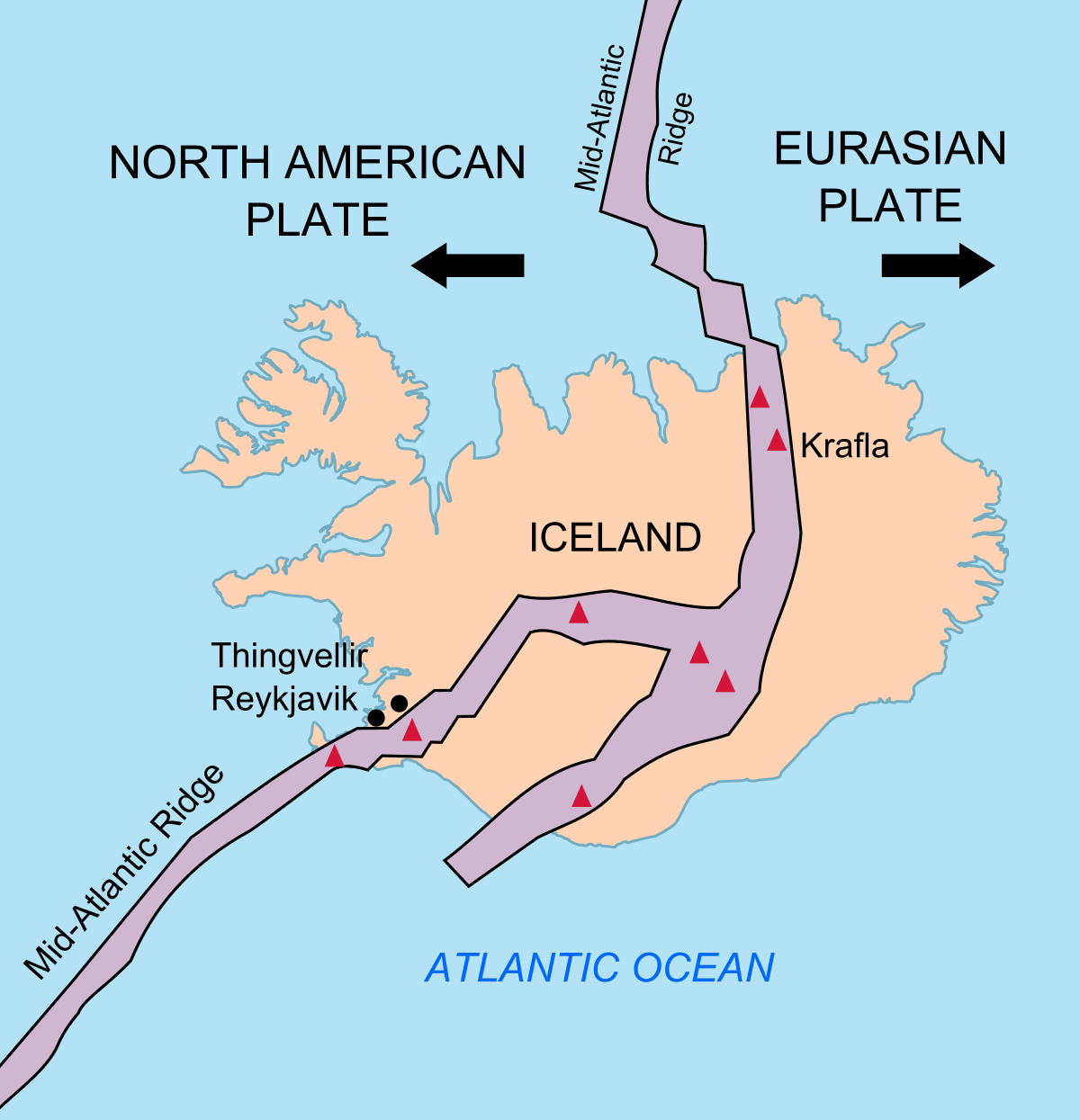
The island experiences constant earthquake activity because it sits on the boundary between the Eurasian and North American tectonic plates. This boundary is also known as the Mid-Atlantic Ridge (MAR).
As the plates move away from each other, they effectively tear the island apart. Iceland is the only place where the Mid-Atlantic Ridge rises above the ocean surface.
The image below shows the spreading tectonic plates and where the Mid-Atlantic Ridge passes through Iceland. It enters the southwest on the Reykjanes Peninsula, going to the east and turning north. Red triangles show the main central volcanoes.
But the tectonic plates spread apart down across the entire Atlantic Ocean. So why is this location so unique, producing a large volcanic island over the millions of years?
The answer is a vertical plume of hot molten rock from the mantle, also called a hotspot or a Mantle plume. Extensive studies have proved that it lies beneath Iceland. Therefore, it is more commonly called the Icelandic plume. The image below is a graphical presentation of the rising mantle plume beneath Iceland.

The high-pressure magma from the depths of the Earth has found its way to the surface with this plume. Following the path of least resistance, it pushed through the cracks between the spreading tectonic plates, starting to build an island.
We can see the Earth’s terrain without the oceans in the image below. You can see the Mid-Atlantic ridge coming from the southwest. And also, you can see the large “lava pillow” of sorts on which Iceland sits. It was produced as the mantle plume pushed through the spreading tectonic plates.

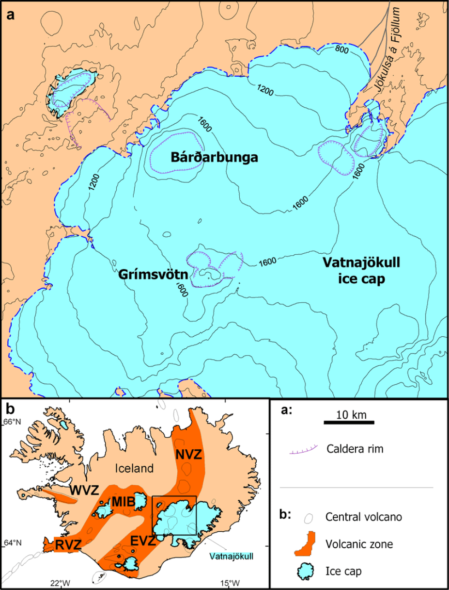
The plume has pulses or cycles, causing periods of higher and lower volcanic activity in Iceland. We have entered a new period of increased activity in recent years/decades. But while the plume lies under the whole of Iceland, its center is under the largest Icelandic glacier called Vatnajokull.
Below is an image that shows the approximate center of where the plume connects with Iceland under the Vatnajokull glacier (black circle). You can also see the mid-Atlantic ridge in orange and volcano locations.
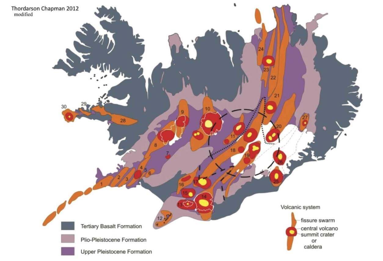
Vatnajokull is the largest glacier in Iceland and the largest ice cap in Europe. It covers roughly around 7.900 km2 but is now reducing over time. Under this glacier, many different volcanoes are hidden, covered by hundreds of meters of solid ice and snow. The image below shows the main central volcanoes beneath northwest Vatnajokull.
THE LAST ERUPTION
There is usually a volcanic eruption in Iceland every 4-6 years. The last eruption began on March 19th, 2021, and ended in mid-September. This eruption was a more peaceful lava flow in the Fagradalsfjall volcanic area. This area is found on the Reykjanes Ridge in southwest Iceland, as seen in the image below by the Icelandic Meteorological Office (IMO).

Below is an image of the lava field during the eruption. The eruptive cones are glowing red, while the erupted lava is already cooling and turning dark in the process. There was near-constant lava spattering from the vents, which have been building cones above the eruption points. Photo by: Almannavarnir/Björn Oddsson.

Below is a video animation that shows the earthquake sequence in the first days of the earthquake swarm. It covers the period from February 23rd to March 2nd, 2021. You can see intense bursts of earthquakes and quite violent ground-cracking activity.
The Icelandic Met Office (IMO) reports that around 151 million cubic meters of lava erupted (5.3 billion cu ft), covering an area of approximately 4.8 km2 (1.9 square miles). Below is a map from @geoviews that shows the eruption cones (triangles) and the final spread of the lava field.

NEW VOLCANIC ACTIVITY 2022
But Iceland is always active in some shape or form. Currently, we have new activity on the Reykjanes peninsula, in southwest Iceland, around Mt Thorbjorn.
In mid-May, more than 3000 earthquakes have been automatically detected in the Reykjanes/Svartsengi volcanic system. The most significant event had a magnitude of M4.3 and occurred on May 15th. The seismicity is located at a depth between 4 and 6 km.
Recent deformation observations (both GPS and InSAR) identified the onset of a new inflation event west of Mt Thorbjorn, likely caused by magma intrusion. Preliminary modeling results indicate the source is located at a depth of between 4-5 km.
In the past month, seismographs detected nearly 9000 earthquakes in the area, mostly related to underground volcanic activity.
EARTHQUAKE SWARM
The Reykjanes region lies in the southwestern corner of Iceland. In the image below, we can see the Reykjanes Peninsula marked. This area experiences near-constant earthquake activity, including occasional stronger events.
We have the last 30 days of earthquake activity on the map below. The main batch of seismic activity is currently centered around the Grindavik area. Color coding tells us the age of the seismic events, which means that lately, earthquakes have been focused more on the Mt Thorbjorn area.

We can see this by zooming further into the red square. Based on the colors, a separate seismic event occurred to the west around three weeks back. The latest activity is mainly centered around the Mt Thorbjorn/Grindavik area, extending to the northeast.

There are many seismographs in this region, so monitoring is excellent. Below we have an example seismograph reading from the Grindavik area. You can see many earthquakes, down to the micro-seismicity. Some events are too weak to be located, but they still count as detected.
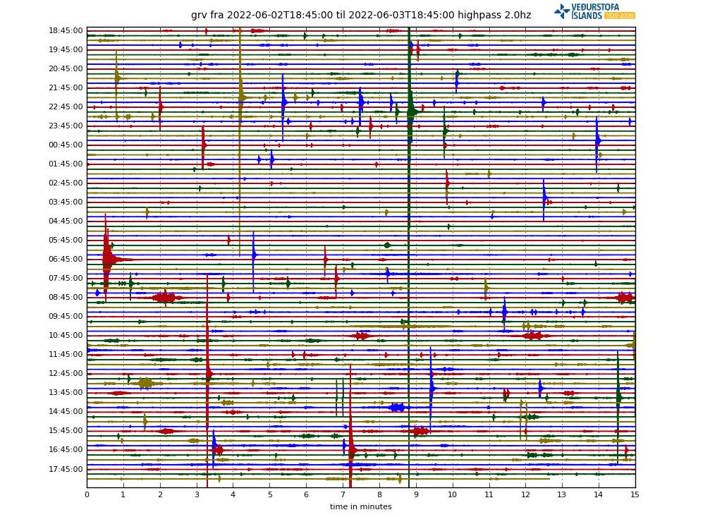
The graph below shows that over 1600 earthquakes have been manually reviewed and located in the second half of May. But in total, over 6000 seismic events have been detected by the monitoring stations in this period.

Looking at the last 48 hours, we can see that the activity is ongoing but at a reduced pace. Around 100 earthquakes daily occur in this area, while around 800 events per day were recorded at the peak activity.

GROUND DEFORMATION
Ground movement around the volcano can also tell us a lot about the activity. We need to find signs that earthquakes are caused by the fresh hot magma entering the volcanic system underground, accumulating and increasing the pressure in the volcano.
Like inflating a balloon until it explodes, the magma accumulating under the volcano increases pressure. The process of ground deformation caused by magma accumulation is called inflation.
Below we have a satellite observation of ground movement during the peak of the earthquake activity in the Grindavik area. We can see a clear uplift signal, which means that magma accumulates underground. From April 28th to May 28th, the land rose by more than 5 cm (2 inches) and was co-occurring with significant seismic activity.

There are also many GPS stations on the ground which monitor ground movement with great accuracy. For example, we have the vertical GPS data below, which shows a rapid inflation period at Mt Thorbjorn since late April.

Increased seismicity and inflation signal that the underlying process must be magmatic. Data analysis and modeling suggest that the deformation source is located around 4-5km deep.
ALERT LEVEL RAISED
In light of the increased seismic activity and the ongoing deformation in the Reykjanes/Svartsengi volcanic system, the aviation color code was elevated from GREEN to YELLOW. Earthquake activity and rapid inflation are always a cause of concern with volcanoes, so a higher alert level is expected.

ROAD TO ERUPTION
But this activity is not new in this region. For example, in 2020, a similar event occurred in the same area: increased seismicity and ground deformation at an equal depth. Below we have the earthquake swarm ongoing in early February 2020.

The strongest earthquakes ranged from magnitude M3 to over magnitude M4 events, similar to the current event. The total number of earthquakes was smaller, but the energy output of the swarm was not much lower.
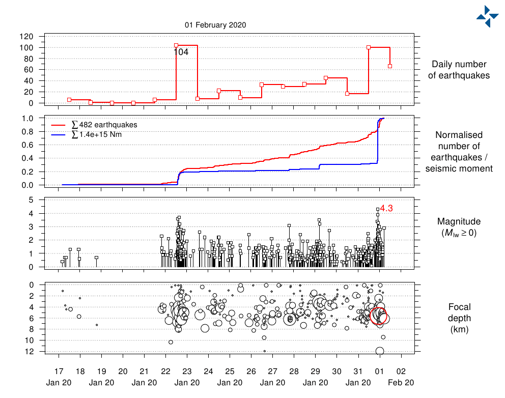
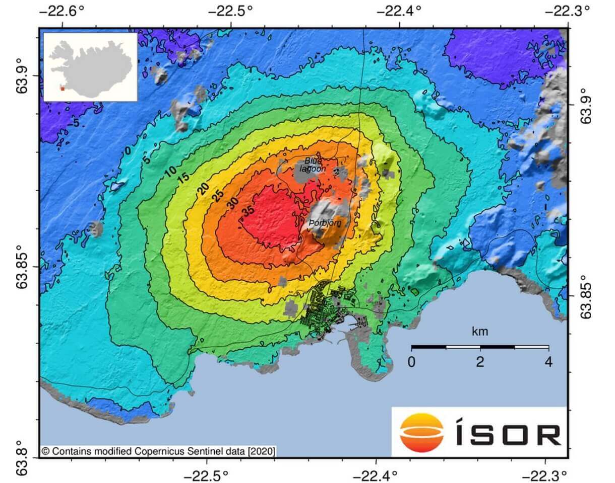
The graphic below, provided by Iceland Met Office, shows the ground inflation between the 18th and 24th of January 2020, as measured by the Sentinel-1 satellite and calculated with the InSAR technique. We can see that the inflation occurred in the same area as now.
We can safely say that this seems to be a similar event with the same cause. Magma is accumulating under Mt Thorbjorn, at around 4-5km depth. This does not indicate that an eruption is imminent. But each such event of seismicity and inflation will push the volcano closer to an eruption.
But there is another volcano in Iceland that is also on yellow alert and has a violent past. That is the Askja volcano.
ERUPTION RISK AT ASKJA VOLCANO
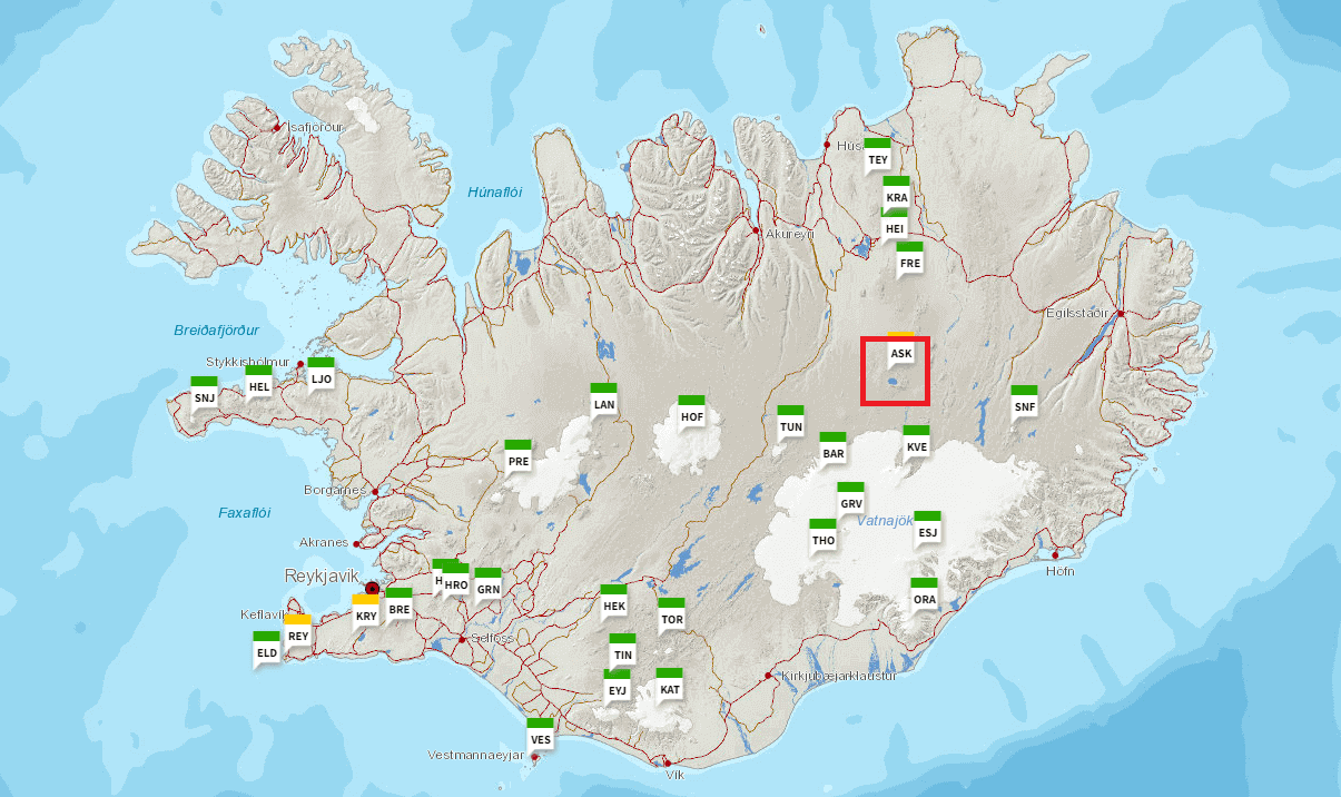
In the image below, we have a map that shows the main central volcanoes in Iceland. We can see the yellow alerts on the Reykjanes peninsula, and marked in red is the Askja volcano on a yellow alert.
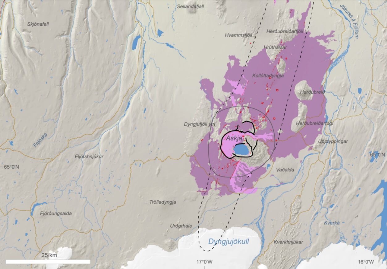
The Askja volcanic system is part of the Northern Volcanic Zone. It is around 190 km long and up to 20 km wide, consisting of a central volcano rising to 1516 m (4973 ft) a.s.l. and a fissure swarm. A caldera complex lies within the central volcano. The youngest caldera is the Öskjuvatn caldera, now occupied by a lake.
The image below shows the Askja central volcano and its related fissure swarm. The pink and violet areas mark the past lava flows from this volcano. It mainly erupts in an effusive style but has a known history of more significant explosive eruptions from the main crater.
In the image below by IMO, we can see the Askja volcano, which is more of a caldera complex. The crater lake formed during its last large explosive eruption in 1875, when ash was deposited over Europe.

We can see the extent of the ash deposits from the 1875 Askja eruption in the image below. A large part of Scandinavia had volcanic ash deposits. The ash cloud was carried over much of Europe and the North Atlantic and would cause serious problems if such an eruption happened again.

As an example, we used the NOAA Hysplit model to produce an eruption simulation. The image below shows the air movement trajectories for an explosive eruption starting early next week and lasting for three days. The elevation is set at 10km (6.2 miles), covering the cruising altitude of air traffic.

In a large eruption, the weather pattern would carry the ash cloud directly into northern Europe. Such an event would close the airspace over the region and likely over other parts of Europe.
CURRENT ACTIVITY
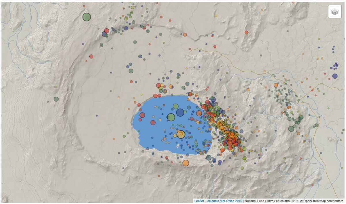
Due to its powerful past, we are keeping a close eye on the Askja volcano. Below we have the earthquake activity in 2022 so far. We can see most of the seismic activity centered around the main crater. However, deeper earthquakes occur to the north and northeast, where its magma source is deep below the ground.
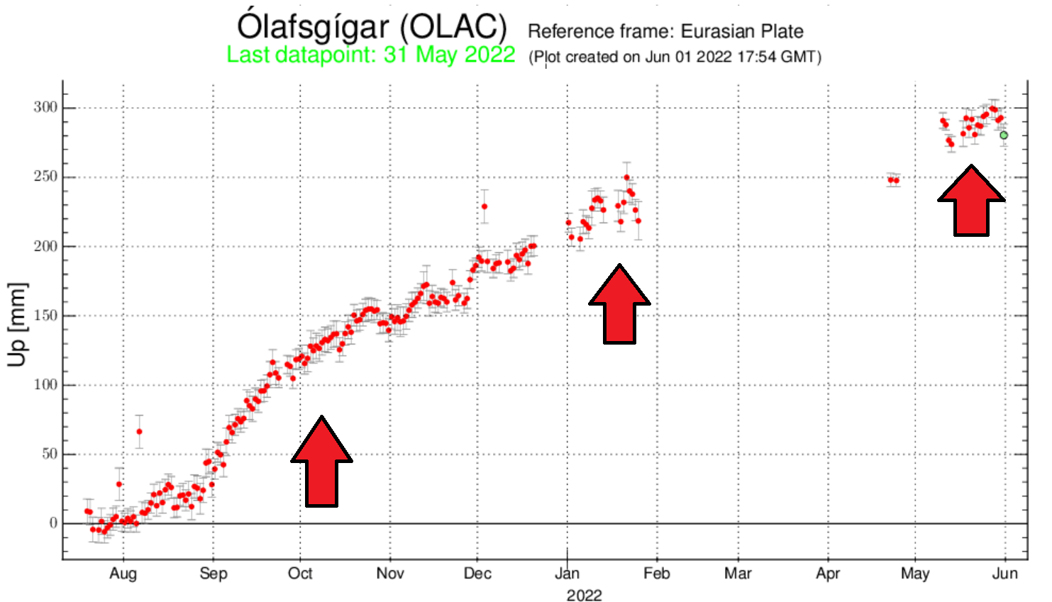
But what is more striking is the ground deformation. Since the end of last summer, the ground at Askja has raised by 30cm (12 inches). This is a significant number and shows that the system is pressurizing.
The GPS plot below shows the vertical ground movement in Askja since last August. Again, we can see that inflation is ongoing at a stable, fast pace.
Askja is another example of earthquake activity occurring with uplift at a volcano. There can be a legitimate reason for concern about an eruption when we see such signals.
Most such events never cause an eruption but show that the system is pressurizing. However, the pressure rises to a critical level at a certain point and can initiate an eruption. So we have to treat each such event as a potential hazard.
We do not know which such event will be the last one that puts the volcano into a critical pressure phase. So monitoring is essential, and thankfully, Iceland has some of the best monitoring equipment on the field.
We will keep a close eye on Askja and all the volcanoes in Iceland, informing you of any significant development. The official agency in Iceland for monitoring volcanoes is the Icelandic Meteorological Office (IMO), where you can find live data, additional information, and all official warnings.