The Summer 2024 forecast update shows a dynamic Summer pattern in the atmosphere, impacted by the transition from the warm El Niño to a cold La Niña cycle. A train of pressure waves and anomalies is forecast to extend from North America all the way into Europe.
Just like over Winter, we again see the atmospheric impact from the ENSO anomaly. This is an area of the Pacific Ocean that changes between warm and cold phases on the ocean surface and below.
Over the Northern Hemisphere, the upcoming months will be a transition period between the El Niño (warm phase) and the La Niña (cold phase), which will leave their mark on the Atmosphere and weather patterns.

ATMOSPHERIC CHANGES
One of the main drivers behind the Winter weather patterns and early spring was the El Niño. This is a warm phase of an oceanic oscillation called ENSO. It is found in the equatorial Pacific and alternates between warm and cold phases.
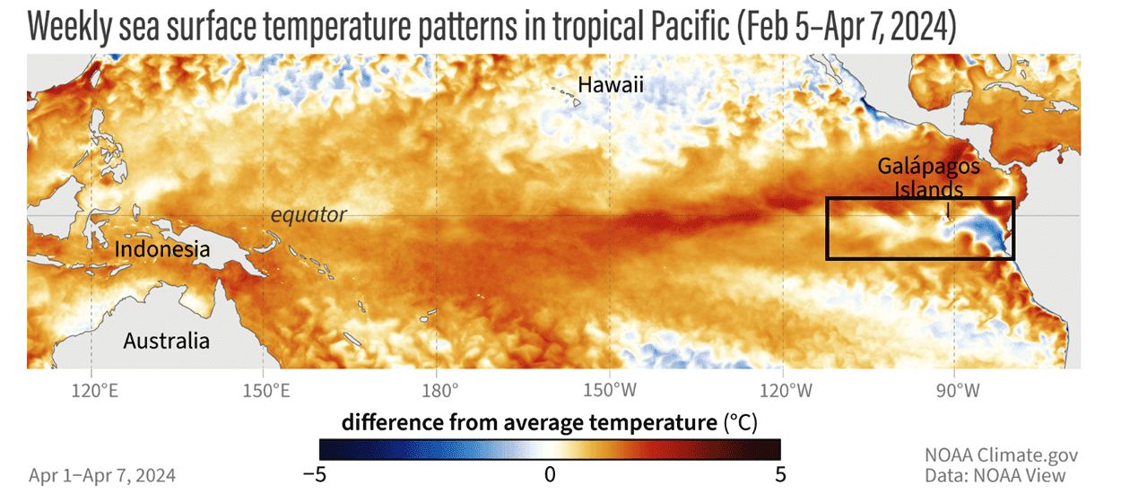
The warm phase of ENSO is called an El Niño, and the cold phase is called a La Niña. Each phase has its specific influence on the pressure patterns and the resulting weather. Below is the latest ocean temperature analysis. You can see warm anomalies over the Equator, but cold areas are starting to emerge in the east.
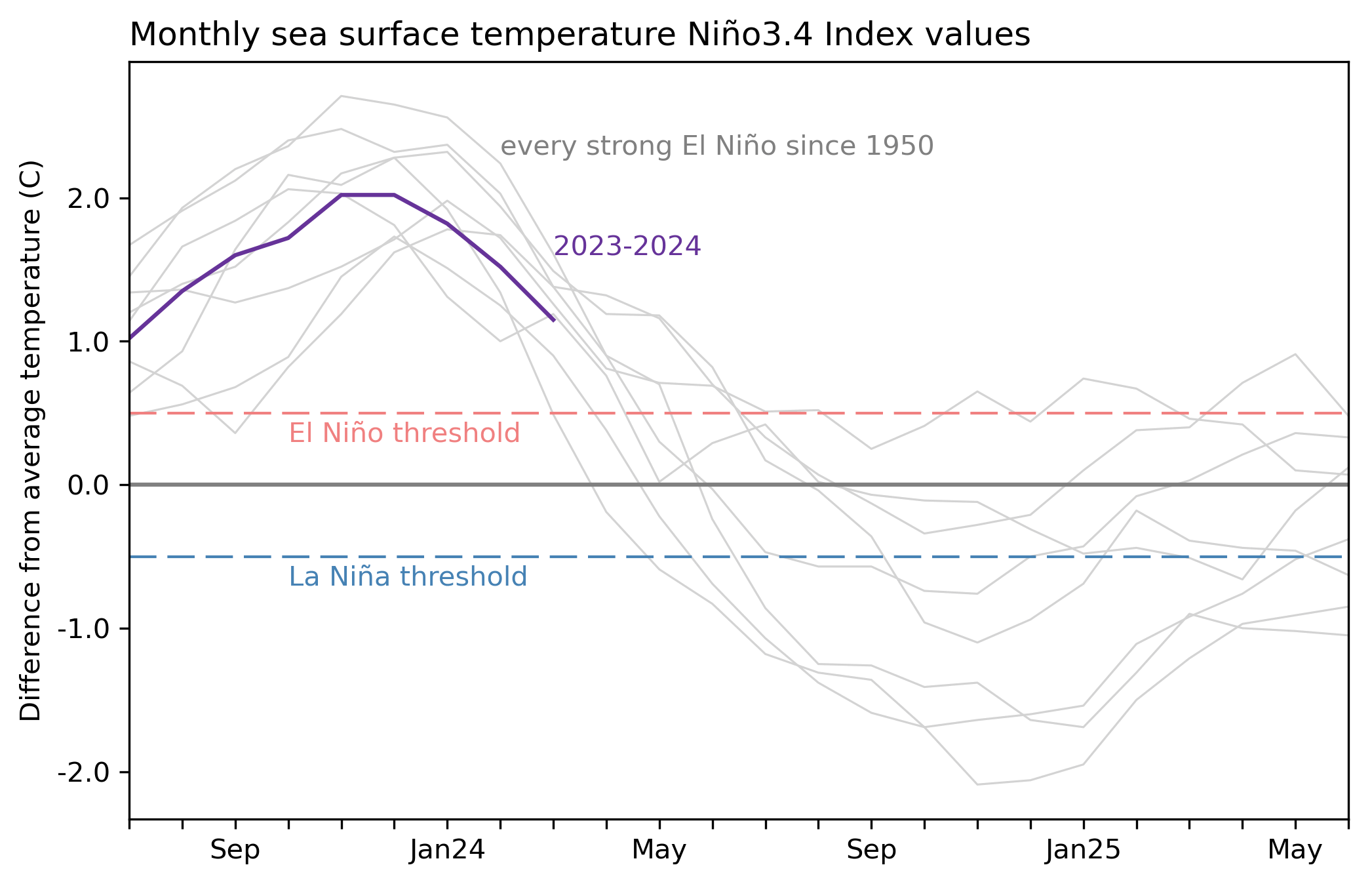
The graph below by NOAA Climate shows the progress in the ocean anomalies across the ENSO regions. Peak warm anomalies were recorded in December. But a rapid drop in temperatures began early this year, with the whole region expected to turn into a negative cycle during summer.
A strong subsurface cold pool is the main pre-condition for an El Niño breakdown. With the aid of the trade winds and ocean currents, these subsurface anomalies move from west to east, eventually coming to the surface over the eastern Pacific.
This can be seen in the image below, which is the latest analysis of the subsurface ocean temperatures in the Pacific. You can see a deep cold anomaly across the tropical Pacific. It is starting to rise in the eastern regions, cooling the surface ocean temperatures.

The video below, produced from NOAA subsurface data, shows this process. You can see the ocean temperature anomalies for the past two months and it shows a rapid breakdown of the warm pool below the surface.
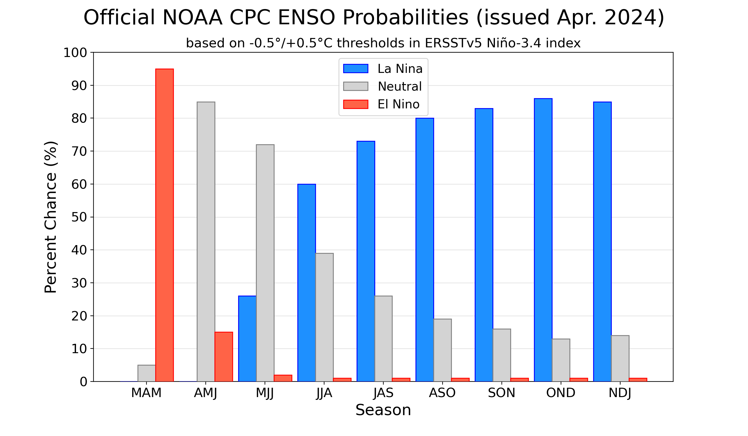
Below is a CPC analysis/forecast graphic that shows the long-range forecast for the main ENSO region. You can see the ENSO seasonal probability, which nicely shows the current warm phase breakdown and the emergence of a very cold cycle in late summer 2024, lasting into 2025.
Looking at the long-range ocean anomaly from the NMME forecast, you can see an area of cold ocean anomalies expanding across the entire tropical Pacific by summer 2024. An event of this scale is strong enough to have a significant atmospheric response during the Autumn and Winter of 2024/2025.

Based on all this forecast data, we know that El Niño is on a rapid decline, with one foot out the door. But, such large events tend to work on longer time scales. This means that it takes some time for the atmosphere to respond to these oceanic changes.
For this reason, the summer 2024 will be in the middle of the transition period from one ENSO phase to another, creating some unusual anomalies in the process.
DOES WEATHER REPEAT?
To understand what such a shift means for the atmosphere, we have produced an image that shows surface pressure during some past La Niña summers. You can see that a surface high-pressure anomaly is the usual La Niña signature during summer seasons in the Pacific Ocean.

Looking at the actual surface pressure anomaly forecast, we can see every similar pattern over the tropical Pacific. High-pressure anomaly is emerging in the eastern Pacific tropics, indicating a growing La Niña. This means that during summer, at least the tropical atmosphere will already be in the new La Niña cycle.
At this point, we have to ask, how did such transition periods look in the past? We decided to look into the data, and we found several years that had a similar transition from a winter El Niño into a summer La Niña.
Below, is the combined summer pressure anomaly for all the transition years we found in the past. You can see a very dynamic pattern of high and low-pressure anomalies. Most obvious is a train of pressure systems from the Pacific over the United States into the Atlantic and Europe.
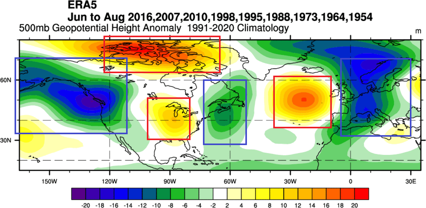
Pressure systems work in pairs, and a notable pair is the low-pressure area in the northern Pacific, and high-pressure over the United States and Canada. Another strong pair is a high-pressure zone over the northern Atlantic, with a low-pressure tendency over Europe.
The temperature anomaly for this transitional pattern shows above-normal temperatures over much of the central and eastern United States and southern Canada. But over Europe, we can actually see a trend for lower temperatures than normal.
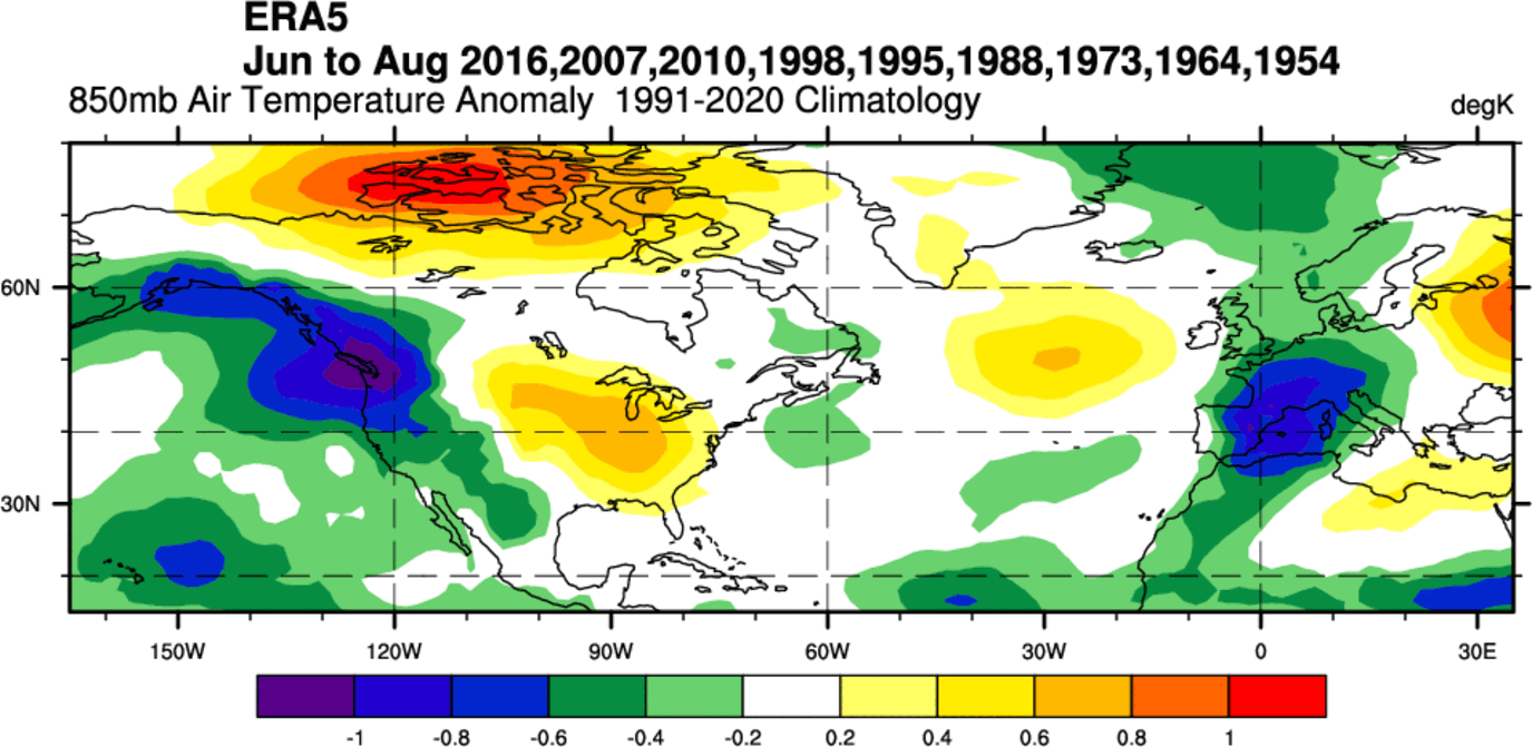
Please note that some of the cold anomalies resulted from using summers over 50 years ago in this mix, when the overall climate was a bit cooler than today.
Now, we kind of know what to expect for this summer. But while this past analysis can show us what to look for, each year has its own differences.
That can be best seen if we look at the actual latest forecast, which is based on the latest conditions in the ocean and the atmosphere, rather than past data.
SUMMER 2024 LONG-RANGE FORECAST
We will examine the forecast trends from the ECMWF, UKMO, and the NMME models. We like using different forecasting systems, as it helps us to see more potential scenarios and see how well the models agree on a certain outcome.
ECMWF is statistically a better long-range model, so we usually start with its forecast. Generally, the ECMWF model is at the top as far as “reliability” goes. But no long-range/seasonal forecasting system can be called “reliable”. This is because we only look at trends and how the weather patterns are evolving on a large scale and over longer periods.
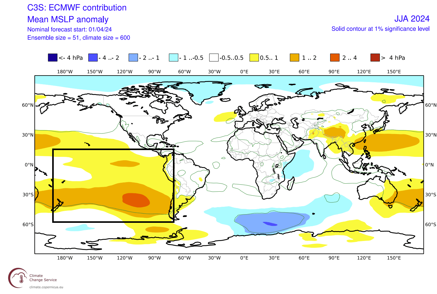
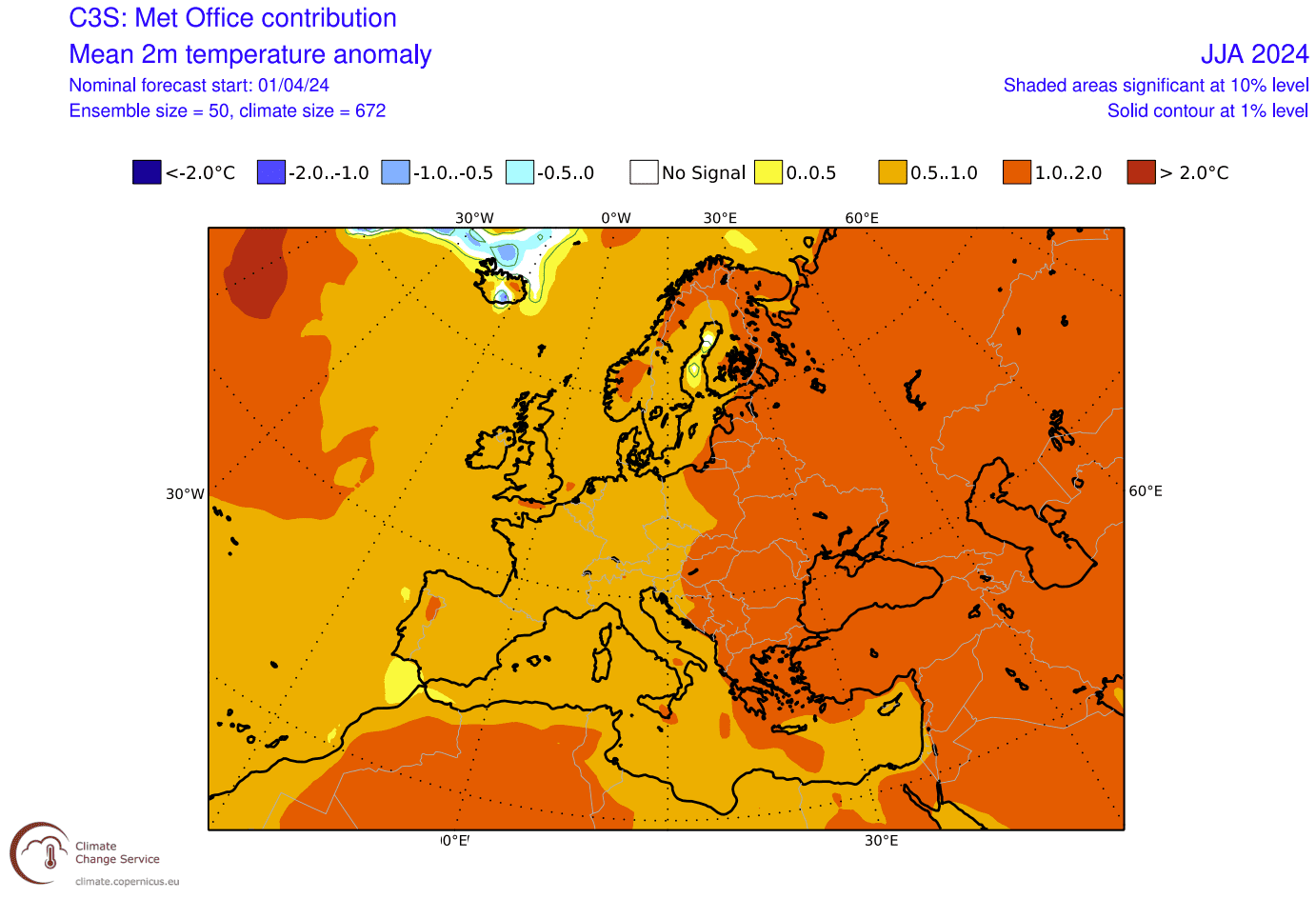
The forecast period we will focus on in all models is June-July-August (JJA 2024). This covers the meteorological Summer and is the peak of the warmest part of the year in the Northern Hemisphere.
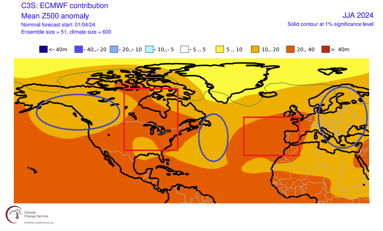
Looking at the pressure anomaly forecast below, you can see a very similar pattern to the analysis we did above for past such years: a pair of low- and high-pressure anomalies over the northeast Pacific and the United States. Another such pair is in the high-pressure over the northeastern Atlantic and a low over Europe.
The temperature anomaly in the lower atmosphere is also very similar to past patterns. We do not see any cold anomalies, as this is just a modeled forecast. But we usually look at patterns where the anomaly is higher than the surrounding area.

So, the signals in this forecast show an area of above-normal temperatures and a higher tendency of heatwaves over the southern United States and up into northern parts and the upper Midwest. Another area is over the southern parts of Europe.
Looking closer at the surface temperature pattern over Europe, we see warmer-than-normal weather over a large part of the continent. The strongest anomalies and most heatwave tendencies are over the central and southern parts of the continent.

Over North America, we can see mostly warm anomalies over the southwestern United States, expanding into the plains, northern United States, and the upper Midwest. Much less of strong warm anomalies is found over the eastern United States.

This shows a high tendency for prolonged heat events over the southern United States, with the heat waves expanding across the plains to the north and towards the upper Midwest.
Canada is also seen warmer than normal across much of the country, under the impact of the high-pressure area. The strongest anomalies are around the Great Lakes and in southern Canada
Going to precipitation, we can see mostly drier conditions forecast over mainland Europe. More rainfall is forecast over the northern parts, again due to the lower pressure and more unstable weather in the westerly winds.

Overall, there is an indication of La Niña’s influence over Europe, which is usually hard to track, even during winter. But, there are some visible patterns that are similar to the expected pressure anomalies for a La Niña summer.
The precipitation forecast for North America also shows less rainfall over the southwestern and western parts of the United States and parts of western Canada. More rainfall is expected across the Midwest, East Coast, and over the deep south.

We also saw a temperature anomaly over the Midwest, so this is an interesting signal. But if we know how the pressure pattern looks, we know that the Midwest will be under a more southerly to southwesterly flow. That brings heat but also moisture, which is supportive of thunderstorm formation.
So when we have an overlap of increased rainfall and increased temperatures, like over the Midwest, it can be seen as an increased thunderstorm activity.
However, we are looking at the early summer trends, so the precipitation picture will become more defined with new runs. But overall, the summer weather pattern over North America does look to have a visible La Niña signature in the weather patterns.
It makes sense, as North America is much closer to the source region in the Pacific, so it is expected to feel the early changes of the new La Niña emerging.
UKMO SUMMER FORECAST
The second model of choice is from the United Kingdom Met Office, hence the forecasting system’s name, UKMO.
Below is the pressure anomaly forecast, and it shows a similar pattern to the ECMWF above. It shows a high-pressure area over a larger part of Canada and the northern United States, extending over the whole Atlantic.
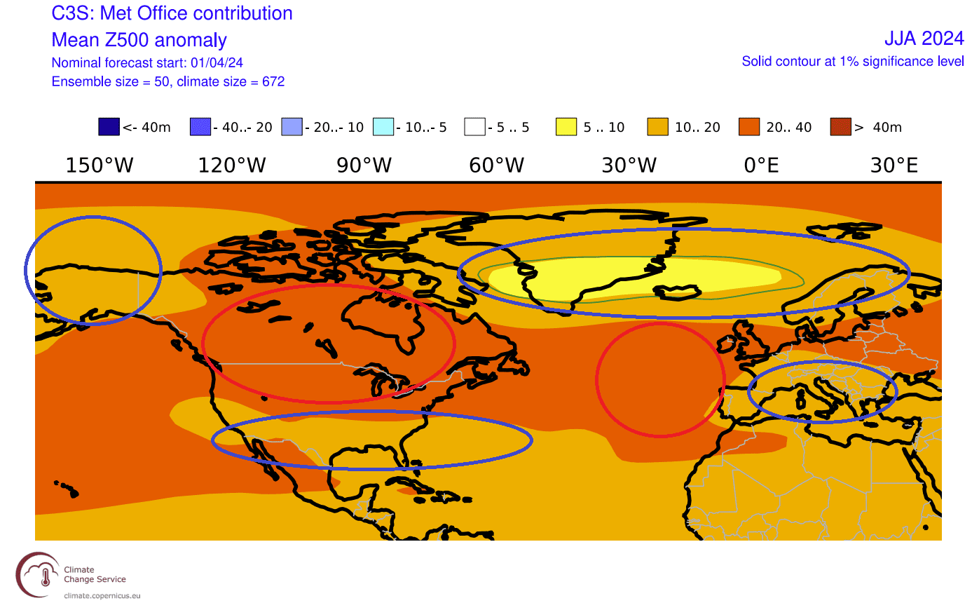
The low-pressure area over the United States is focused more on the southern part of the country. Over Europe, the low-pressure zones are also separated into two regions, unlike a single area in the ECMWF.
Looking closer at the surface temperature pattern over Europe, it is quite different from the ECMWF. Here we see the main heatwave tendency more towards the east and north. Western parts are still under warm anomalies, but the pressure pattern keeps the anomalies lower.
Due to the large high-pressure zone covering both countries, we can see a large area of strong warm anomalies over North America. Peak anomalies are found in the upper Midwest and southern Canada. Southern parts of the United States do not show the strongest anomalies, as it is under a low-pressure tendency.

This shows a high tendency for prolonged heat events over the central and northern half of the United States, with the heat waves expanding across the border into southern Canada.
The precipitation forecast shows normal to drier conditions over far western and southern parts of Europe. More rainfall is forecast over the far northern parts. Central parts are shown with some increased rainfall potential.

The precipitation forecast for North America also shows less rainfall over the southwestern and northern United States, central plains, and southern Canada. More rainfall is forecast for the west coast of the United States and over western and far eastern Canada. No clear trend is shown for the eastern United States.

Combined with the strong temperature anomalies over most of the United States, this shows a strong drought potential for the southwestern United States and the Plains.
NORTH AMERICAN MODEL FORECAST
In contrast to the European models, we like to use the North American Multi-Model (NMME) forecast. It combines several long-range solutions from different forecasting centers across North America into one single forecast.
The North American temperature forecast below shows a somewhat similar picture to the ECMWF. NMME shows that the summer will be warmer than normal over the Midwest, Northeastern, and Southwestern United States, with a gap in warm anomalies across the central United States toward the east.

Another area of strong warm anomalies is forecast over far western and far eastern Canada.
The NMME precipitation forecast for North America shows less rainfall over southern and central Canada, the southwestern United States, the central plains, and the upper Midwest. Wetter conditions are forecast over the far northern and eastern United States and over the southeast

The potential for drought conditions is higher than usual over the southwestern United States and parts of the central plains. This is also seen in the other two modeling solutions, which increases the confidence in this scenario.
SUMMER 2024 OFFICIAL FORECAST
The NOAA official Summer temperature outlook shows that most of the United States is expected to be warmer than normal, apart from the northern Plains. The core warm anomalies are so far focused on the western parts of the United States and the far east.

This is unlike the models above, but this is a forecast from late March, so it’s normal to see some difference from the more recent model forecasts. That is especially true when comparing these human-made outlooks to computer model products like the ECMWF and NMME above.
The official Summer precipitation outlook is closer to the model forecast. We see an equal-to-higher probability for more precipitation over the eastern parts of the United States.

All models also show drier conditions over the western and southwestern United States, so this official forecast agrees with that scenario. But, there is less agreement over the northwestern United States, where less precipitation is only shown in the official outlook but not in the models.
We will release regular updates as fresh forecasts and data are available. So make sure to bookmark our page. Also, if you have seen this article in the Google App (Discover) feed, click the like button (♥) there to see more of our forecasts and our latest articles on weather and nature in general.
SEE ALSO: