April has continued with an astonishing warmth across Europe, with hundreds of monthly temperature records shattered across large parts of the continent. But this week, the historic heatwave is coming to an end. And it will be a dramatic temperature change, from above +30 °C over the weekend into single digits by mid-week. On top of it, a sharp cold front will likely bring snow into lowlands across central Europe and the Balkan peninsula. Followed by an increasing risk of damaging frost.
You are reading this correctly. Who would think a harsh reality would come after their pleasant, although significantly too warm (hot) days?
This week, a large part of Europe is returning to a cold period, which may last until the end of the month.
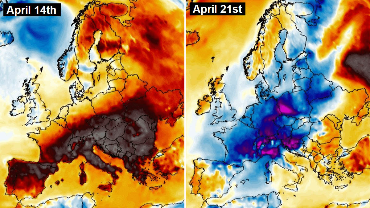
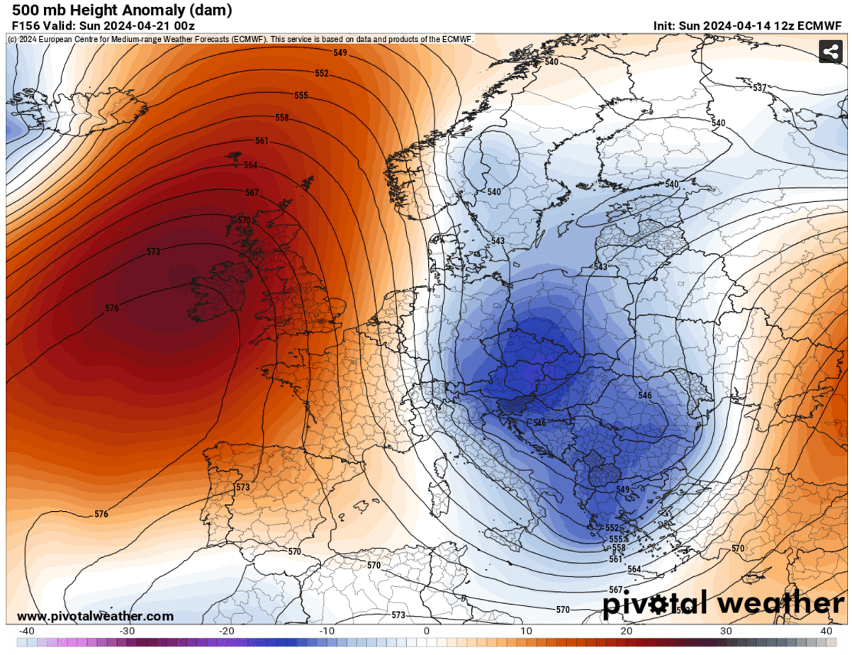
The featured image below represents the temperature anomaly between the past Sunday (April 14th) and the following Sunday (April 21st), from around 15 °C too warm to more than 10 °C below average temperature.
The reason behind this upcoming weather change across Europe is the flipping pattern. It goes from the blocking High established across Europe into a dipole pattern, meaning strong high pressure develops over the North Atlantic, with troughs and cold weather trapped over the continent.
It starts with the solid upper trough ejecting off the northeast North Atlantic on Monday, rapidly digging towards central Europe on Tuesday and the Balkan peninsula by mid-week.
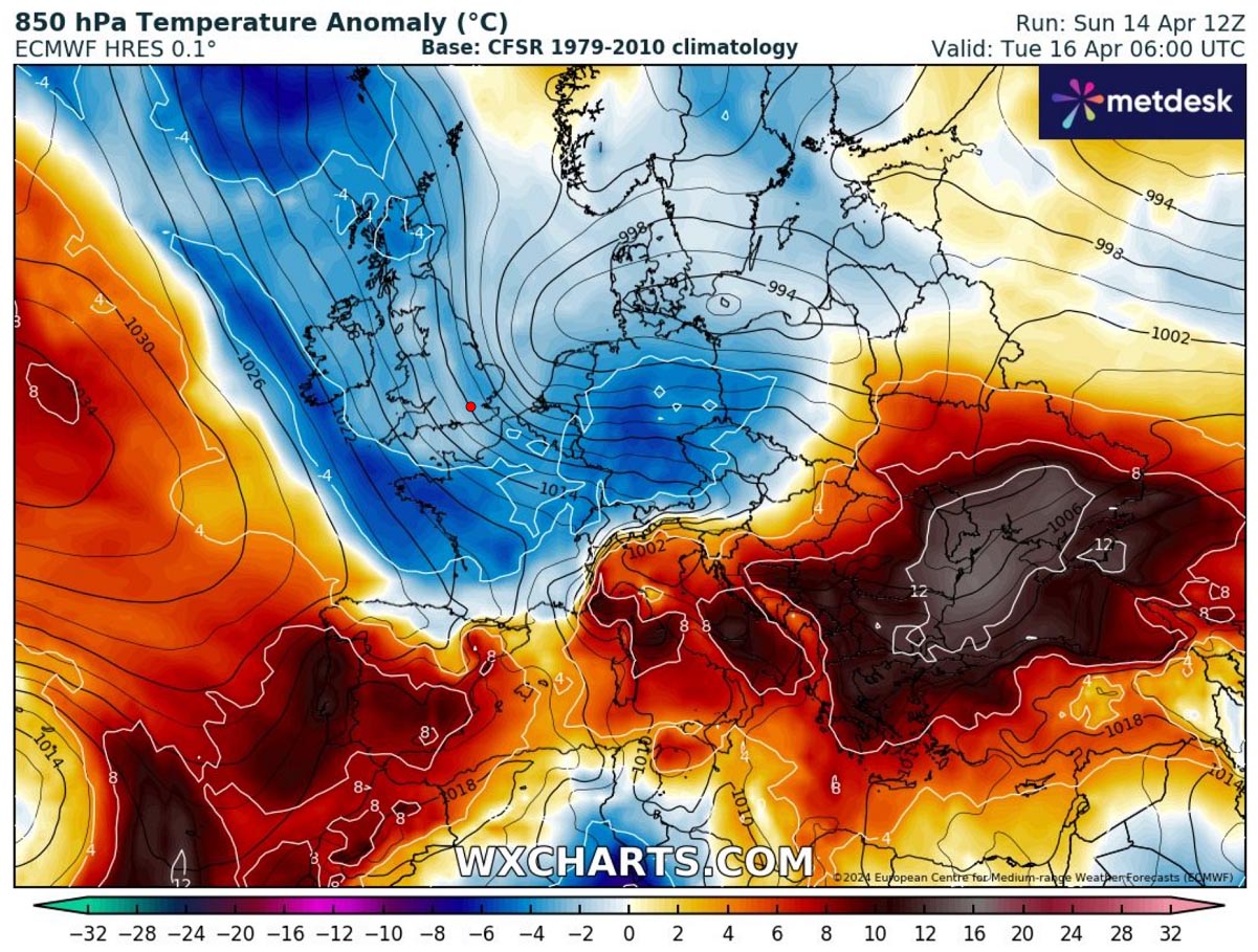
The Meteogram charts for Munich (Germany) and Zagreb (Croatia), representing 850 mbar (approx. 1250m above sea level) temperature over the next 14 days, are pretty evident regarding the significant temperature drop.
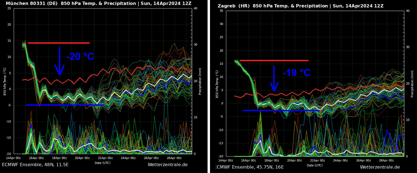
From Sunday’s 15 °C at this level to around -5 °C by Tuesday. So, nearly 20 °C drop in less than two days. We can also see that the cold period will extend for at least another week, possibly even longer. Thus staying below the long-term average for the second half of April.
The video below briefly summarizes the general conditions over the next 10 days.
Next, we will investigate how the pattern and dramatic weather change will evolve. Before we dig into details, let’s summarize the historic heatwave we have just experienced during the past few days.
Historic heatwave shattering hundreds of maximum temperature records across Europe
An unprecedented heatwave spread across Europe in early April, with a heat dome established across the southern parts of the continent. The peak occurred this weekend, with hundreds of historic high-temperature records broken.
To add even more astonishing details, many countries have recorded their first-ever daytime temperature above +30 °C, which has never happened before in April for so many stations, from France to Germany, Austria, Slovenia, Croatia, Bosnia, and Italy. Not to mention, we are still in the first half of the month!
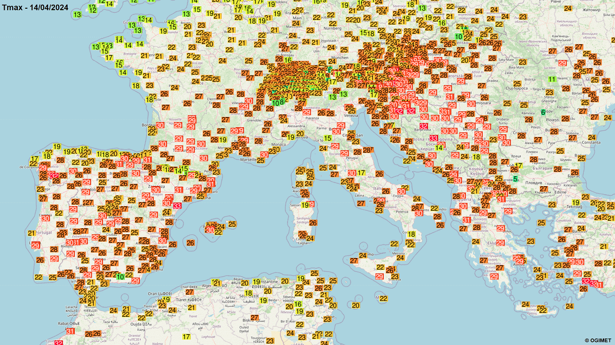
This Sunday, April 14th, the heatwave’s peak resulted in many new highest temperature records, including national records in some central and southern European countries.
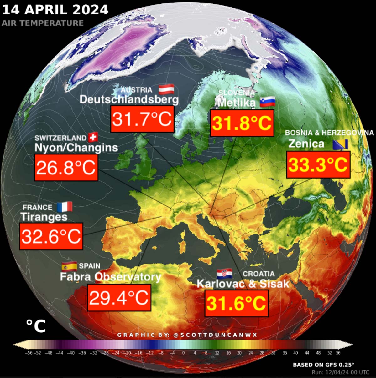
Below is the image posted by meteorologist Scott Duncan on X. It is hard to imagine these temperatures are April’s values.
After Friday and Saturday, Sunday was another scorching day in France: At least 146 highest temperature records were broken, up to +32.6 °C in Tiranges. The intense heatwave across southern France has been persisting for several days. Areas that shattered records also include Le Luc, Albi, Amberieu, Lyon, Brive, Muret, Figari, Millau, Chamonix, and Le Puy.
Nearly 500 maximum temperature records were broken in France in the last few days.
There was also an exceptional April heat record at the Fabra Observatory above Barcelona, Spain. Sunday’s peak temperature was +29.4 °C, which smashed the previous April record by more than 2 °C.
At least 42 weather stations also set new highest April temperature records in Slovenia, with officially +31.8 °C in Metlika. +31.4 °C was reported at the airport Cerklje ob Krki, +31.2 °C in Doblice near Crnomelj.
Just south of these locations, across the border into Croatia, +31.6 °C was recorded in Karlovac and Sisak. Both smashed the station records and set the new national temperature record for April in Croatia. +30.6 °C was recorded in Zagreb airport, and +29.5 °C in Ogulin.
Bosnia and Herzegovina also set a new national record for April: +33.3 °C in Zenica. Additional stations above the 30 °C mark were +32.1 °C in Bihac, +32.0 °C in Banja Luka, and +30.1 °C in the capital city of Sarajevo.
Austria has also set historical temperature records; one-third of the country’s stations broke monthly records. +31.7 °C was in Deutschlandsberg, +30.9 °C in Villach. Also +31.6 °C in Bruck, +31.0 °C in Hartberg, +30.7 °C in Innsbruck, +30.5 °C in Graz and Leoben.
Switzerland broke 18 more records, with some stations having data since the mid-1800s, so more than 150-year-old records have been destroyed. Tons of monthly records have been broken in Switzerland, such as Geneva +28.3 °C, Payerne +27.5°C, and many more.
Part of the North Itraly plains has also peaked above the +30.0 °C mark.
Dramatic pattern flip over Europe follows as we head into the 2nd half of April
Heat waves can’t last forever, and an intense cold period will develop soon. But this one will come with a bang, with a dramatic temperature change. From summertime to cold and even wintry weather in some areas, the weather continues its game in style, with significant anomalies from one side to another.
As we head into mid-April, the general weather picture over Europe reveals a decaying blocking High on the south but a strengthening Upper High over the North Atlantic. This change induces a deep trough over northwestern Europe that will further intensify as it digs into continental Europe by Tuesday.
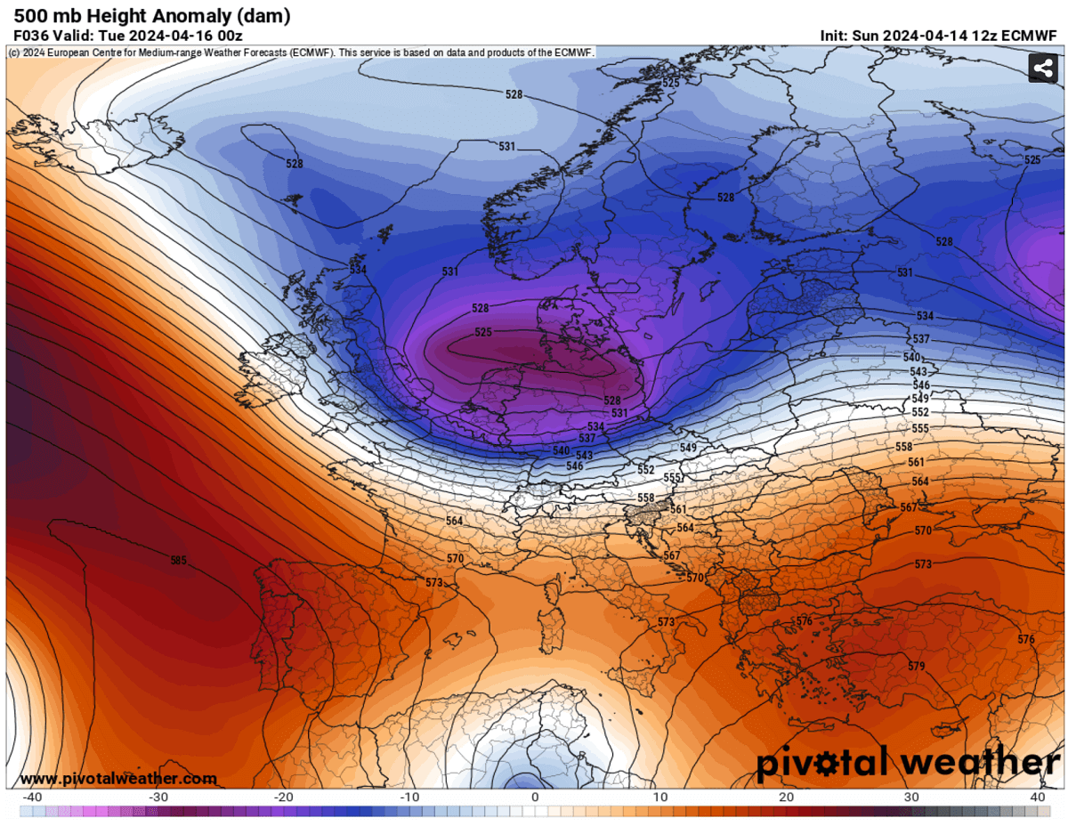
While Monday and Tuesday will still allow temperatures to be significantly high across southern Europe, a sharp cold front will be racing south-southeast across central Europe, bringing much colder weather.
A surface low will be established beneath the core of the deep trough above, sitting over northern Germany, the Baltic Region, and Poland on Tuesday. Thus, the surface cold front will be pushed towards the Alps. Heavy rain, including thunderstorm activity, will be associated with the moving front across western Europe on Monday.
A secondary low will develop across the northern Mediterranean, with the upper trough progressing towards the south. Allowing the front to slow down on Tuesday will cause the cold in the lowest levels to spread rapidly in Austria, Hungary, and Slovenia.
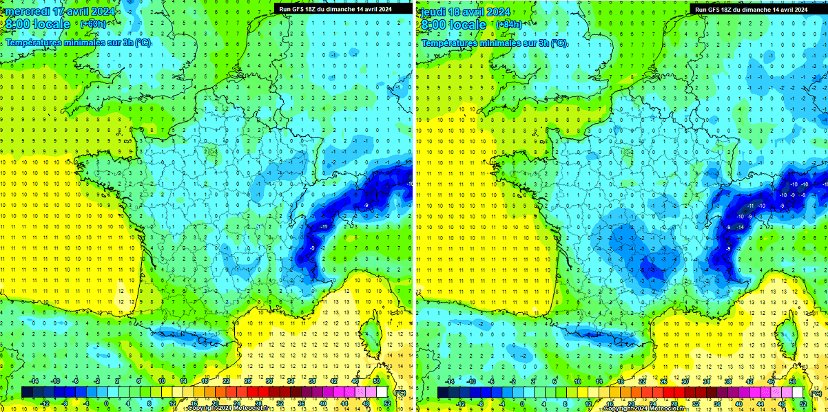
This results in heavy precipitation and possibly even snow close to the lowlands on Tuesday nights. Rapid temperature drops across southern Austria and Slovenia could lead to heavy snowfall in the predawn hours on Wednesday morning. Also associated with strong winds.
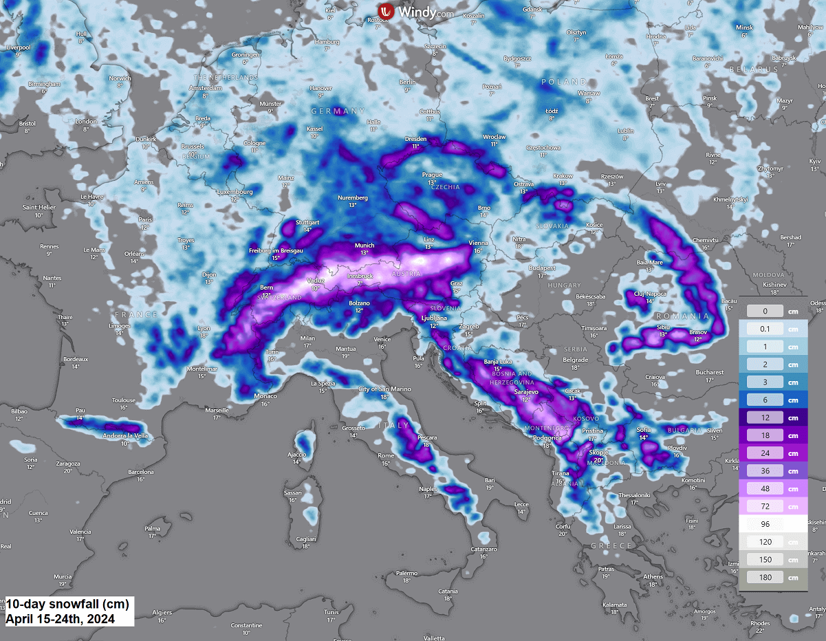
A cold front will continue southeast on Wednesday, with heavy rain and the potential to change to snow along the western Balkan peninsula, where higher terrain is. A swath of 5-10 cm, possibly 20 cm or, locally, even more snow, will be possible from southern Austria’s lowlands across Slovenia, Croatia, Bosnia, and Montenegro.
Fresh snow will also accumulate across the Apennines and Carpathians in Romania and the High Tatras in Slovakia.
The Alps will receive quite a lot of fresh snow over the next 10 days, as seen in the chart above. There may be more than 100 cm of fresh snow by early next week.
Cold spells will bring an increasing risk of damaging frost
Following the cold front, much colder weather will overspread most of the continent by mid-week and extend towards the weekend. Compared to recent days, this will be a fundamental change and harsh reality; we have been in way too hot airmass lately.
Tuesday and Wednesday will bring cold mornings for Western Europe, with the lowest temperatures near freezing or a few degrees below. The UK could see the coldest morning on Wednesday, while France, Benelux, Germany, and Spain on Thursday.
A few degrees below freezing will be possible, particularly if winds weaken and temperatures drop significantly overnight.
This will introduce an extreme risk of damaging frost to agriculture and blossoming trees. Warm weather has also been observed since the beginning of 2024; these have been blooming way ahead of schedule this spring.
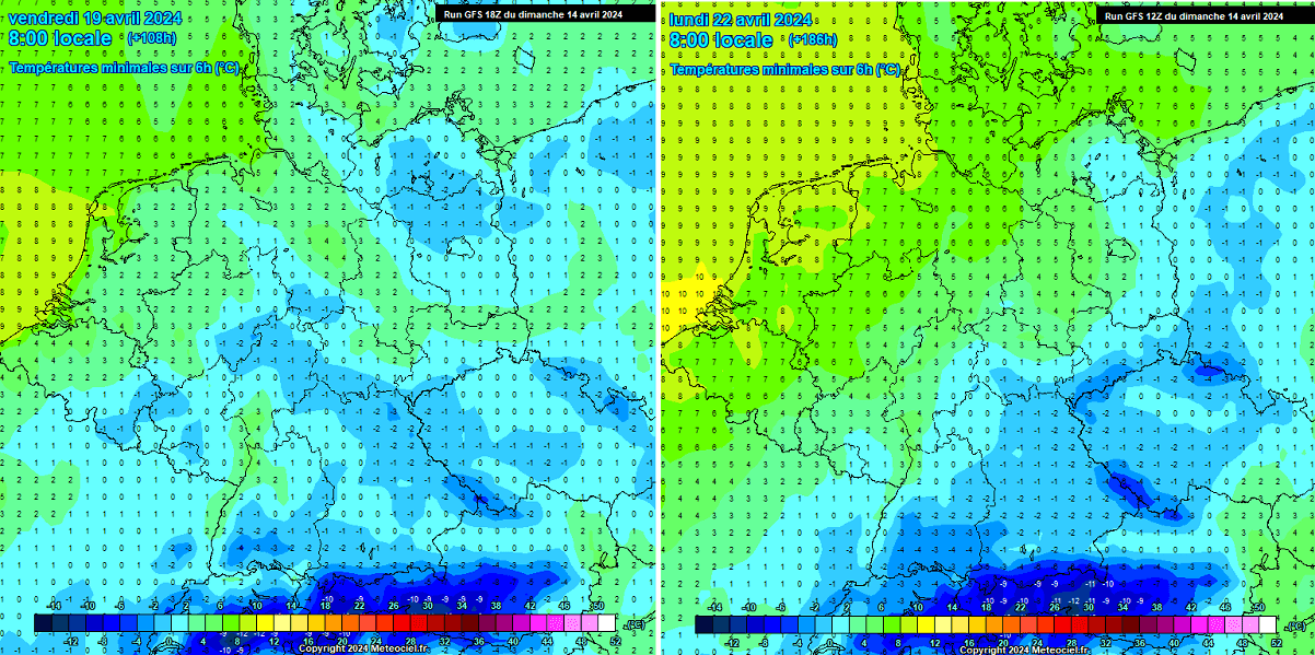
Parts north of the Alps will see cold extend towards the weekend. Large parts of Germany, Czechia, and Poland are under significant risk for frost in the mornings from Wednesday into the weekend. As another cold spell re-intensifies, even colder weather will be possible from Sunday through Tuesday next week. We will discuss this further below.
Once the skies clear behind the front and on the southern side of the Alps, an increasing risk for destructive morning frosts will develop for Austria, Slovenia, and Croatia. Especially from Thursday onwards.
If the snow accumulates in these regions on Wednesday, that’d also be an additional booster for more significant cold morning temperatures.
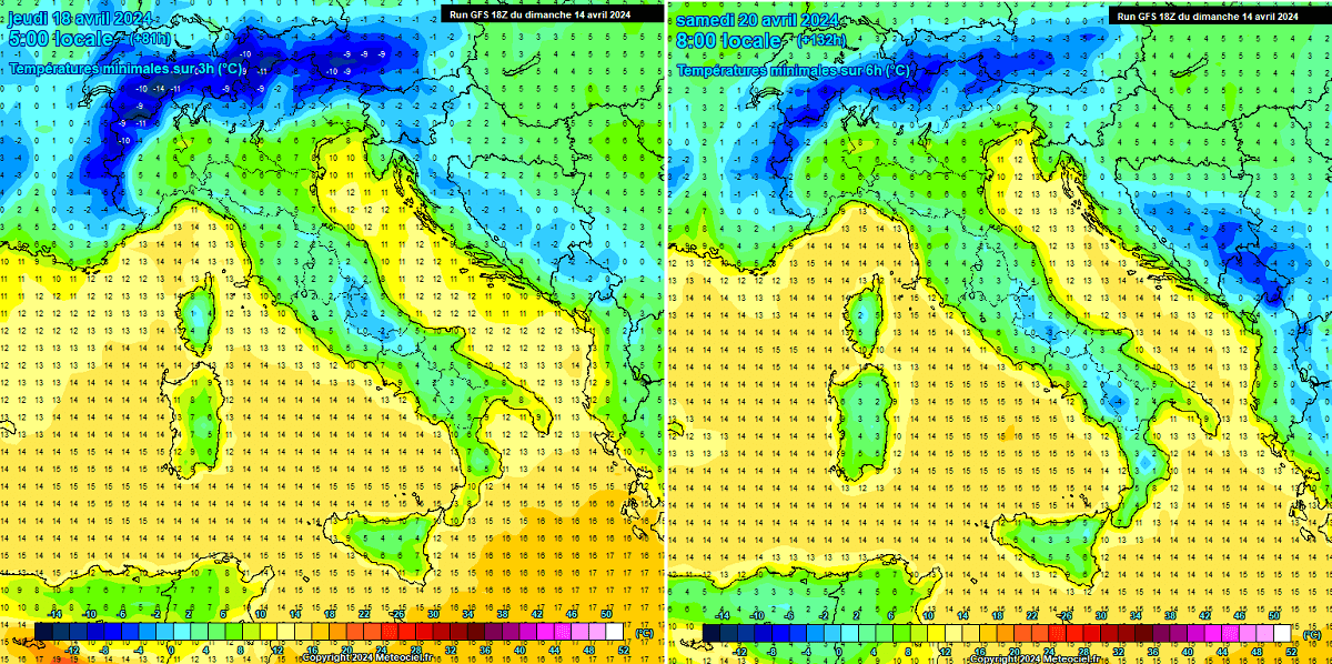
Spring-blooming trees are in full swing now, and damage to fruit trees and vineyards could be catastrophic.
Another cold blast is likely to follow over the weekend and next week, potentially even lower temperatures and more frosty mornings
As discussed above, the cold spell could last at least a week, possibly until the end of April. The weather models are recently simulating the genuine concern: a textbook dipole weather pattern with strong blocking High over the North Atlantic and deep low over continental Europe.
This leads to another cold blast over already below-normal temperatures established this week, which means the potential for damaging morning frosts and catastrophic consequences might follow.
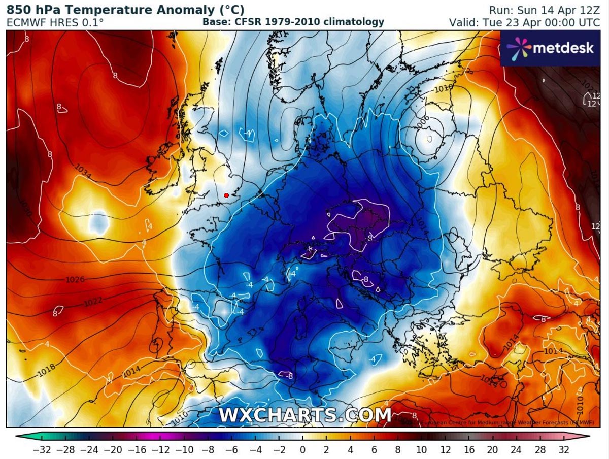
The 850 mbar anomaly chart below is a real deal. An 8-10 °C colder-than-average temperature anomaly for mid-levels in late April is beyond extreme. If current model predictions are verified, most of central Europe and the north-central Mediterranean will experience a significant cold outbreak for a few days starting the following Monday.
This would allow night and morning temperatures to continue reaching near and below freezing. Remember that fully blooming trees and vineyards don’t need extremely low temperatures. Even -2°C can do significant damage.
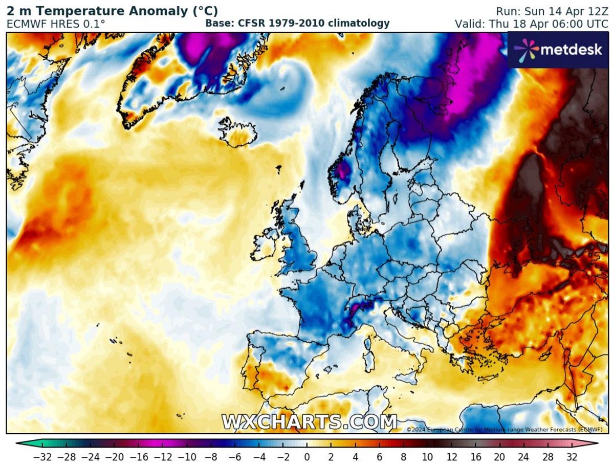
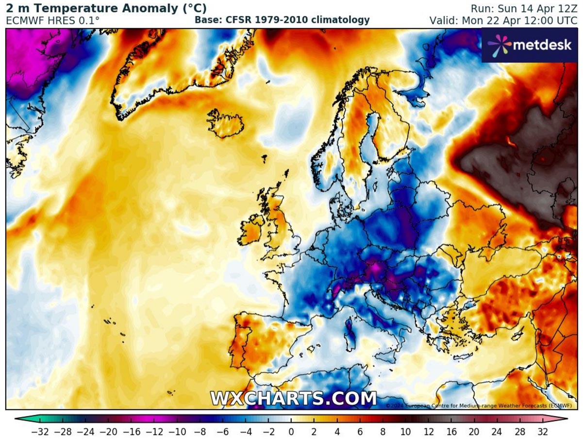
Attached below is the 2m temperature anomaly for Monday. It indicates temperatures would be 12 to 16 °C below average for late April. We can see the cold will spread across the continental part of Europe.
This deep cold pool will likely continue for a few more days after Monday next week. We are closely monitoring the pattern’s evolution, so stay tuned for further updates on our social channels.
Wxcharts, Windy, and Pivotalweather provided images used in this article.
See also: