Arctic sea ice extent in May 2022 was 12.88 million square kilometers (4.97 million square miles) tracking above levels not seen since 2013. The Hudson Bay, the Beaufort Sea, the Canadian Archipelago, the Eats Siberian Sea, the Laptev Sea, the Chuchi Sea, and the Kara Sea are still almost completely frozen as it should be at this time of the melting season. Ice loss occurred primarily in the Bering Sea, the Barents Sea, and within Baffin Bay and Davis Strait.
ARCTIC SEA ICE MAY 2022
The Arctic sea ice extent on June 1st, 2022, the first day of the meteorological summer, was 12.29 million square kilometers (4.75 million square miles). The Average for May 2022 was 12.88 million square kilometers (4.97 million square miles).
Although this extent is the highest in the last 9 years in the satellite record, it is actually 0.41 million square kilometers (0.16 million square miles) below the 1981-2010 average and the 16th lowest extent ever recorded on this day of the year.

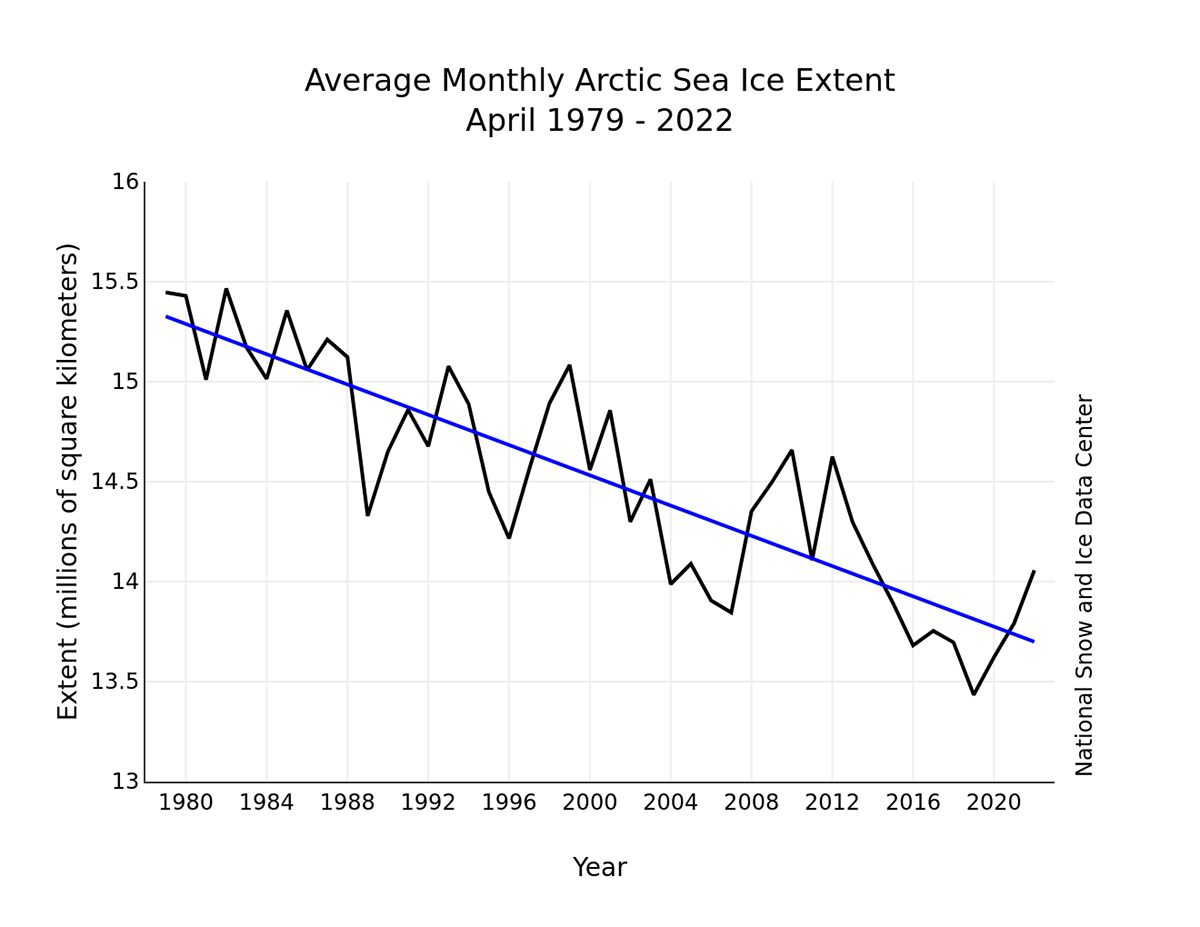
With a relatively slower melt, the average May 2022 sea ice extent is anyway low. Despite there being the same extent in May 1989 or 1995, the long-term negative trend of -2.5% per decade is clear. Nevertheless, the lack of sea ice at this time of the year is 9.3% above the record low set in 2016 with 11.24 million square kilometers (4.34 million square miles).

On June 1st, 30% of the normal sea ice melt was cleared. This is 20 days after the 20% day. Normally, we will see 40% gone in 18 days, 50% in another 13, 60% in another 11, 70% in another 11 days, and so on.
On a decadal basis, if in 2022 sea ice extent was barely greater than 12 million square kilometers, on 1 June 2012 was 12.11 million square kilometers. 10 years earlier, in 2002, was 12.24 million square kilometers, then 12.67 million square kilometers on June 1st, 1992, and 13.19 million square kilometers on June 1st, 1982.
WHAT IS SEA ICE
Sea ice means all sorts of ice that form when seawater freezes. Sea ice that is not fast ice refers to drift ice, and, if the concentration exceeds 70%, it is called pack ice. When sea ice concentration is lower than 15% this is considered open water, and the boundary between open water and ice is called the ice edge.
Sea ice cover in the Arctic grows throughout the winter and peaks in March. In September the sea ice extension reaches its minimum, which is generally only around one-third of its winter maximum. In order to get a proper picture of the sea ice state, there is a need of determining both extents and volumes.
Such numbers primarily include the ice thickness, generally linked to the age of the ice. In the image below, Arctic sea ice climatology from 1981-to 2010 by the Snow and Ice Data Center, University of Colorado, Boulder.

Winter ice extent is generally a weaker indicator of what the ice extent will look like in September when we will face the annual minimum. The seasonal cycle of Arctic sea ice is characterized by the maximum annual extent in March, decreasing through spring and summer to an annual minimum extent in September.
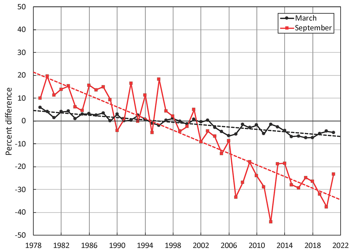
Since 1979 it has been possible to monitor sea ice by satellite. At present, We have 44 years of reliable information on the extent of the sea ice cover. The sea ice had continuously diminished and particularly since the end of the 1990s. Nevertheless, the winter trend is different from the summer trend.
In the image below the Arctic sea ice extent develops at the end of the winter season (March maximum) and by the end of the summer (September minimum)
Ice loss in May 2022 occurred primarily in the Bering Sea, the Barents Sea, and within the Baffin Bay and the Davis Strait. However, several openings, or polynyas, in the pack ice have started to form, mostly within the eastern Beaufort Sea, the Chukchi Sea, the Laptev Sea, and around Franz Joseph Land in the northern Barents Sea
WHAT IS A POLYNYA
Polynya is a geographical name describing an area of unfrozen seawater within the otherwise contiguous pack ice or fast ice. The word derives from the Russian language and refers to a natural ice hole. It was first adopted in the 19th century by polar explorers to describe navigable portions of the sea.
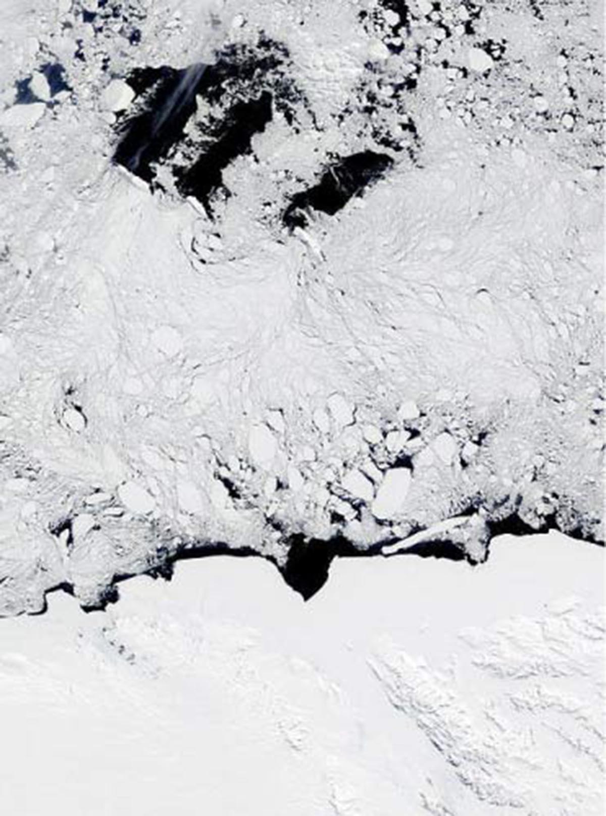
Polynyas occur within sea ice stretches even though the air temperature is below freezing. Such gaps in the thick ice pack provide direct interaction between the ocean and the atmosphere, which is important for wildlife.
There are two main types of polynyas: coastal polynyas, and mid-sea or open-ocean polynyas.
Although coastal Polynyas are mainly created by strong winds pushing the ice away from the coast, they are subdivided into two different types: Sensible-heat polynyas, and Latent-heat polynyas.
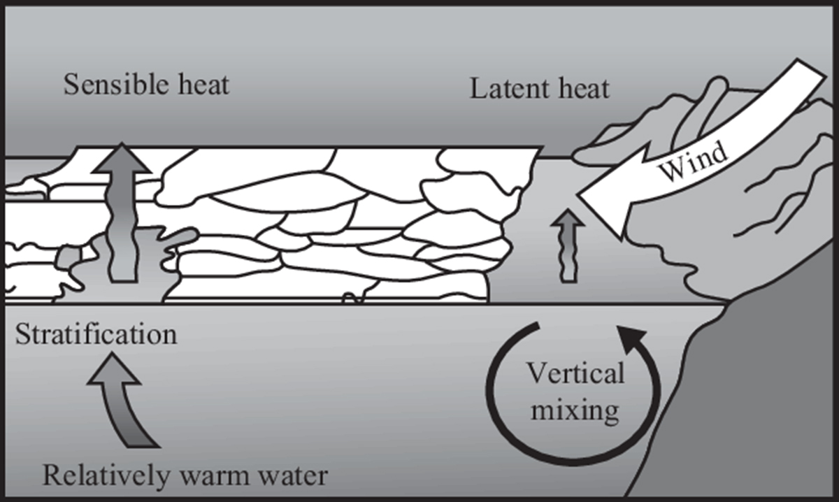
A sensible heat polynya is thermodynamically driven and usually occurs when warm water upwelling keeps the surface water temperature at or above the freezing point. This cuts ice production and may stop it altogether.
A latent heat polynya forms through the action of strong katabatic winds. Winds act driving ice away from a fixed edge such as a coastline, fast ice, or an ice bridge. The polynya forms primarily when first-year (young) sea ice is driven away from the coast. This leaves an area of open water within. The new ice is then piled up downwind toward the first-year pack ice.
In the image below the polynya opened in the Last Ice Area in May 2020.

REGIONAL DIFFERENCES IN ARCTIC SEA ICE IN MAY
The Hudson Bay, the Beaufort Sea, the Canadian Archipelago, the Eats Siberian Sea, the Laptev Sea, the Chuchi Sea, and the Kara Sea are still almost completely frozen as they should be at this time of the melting season.
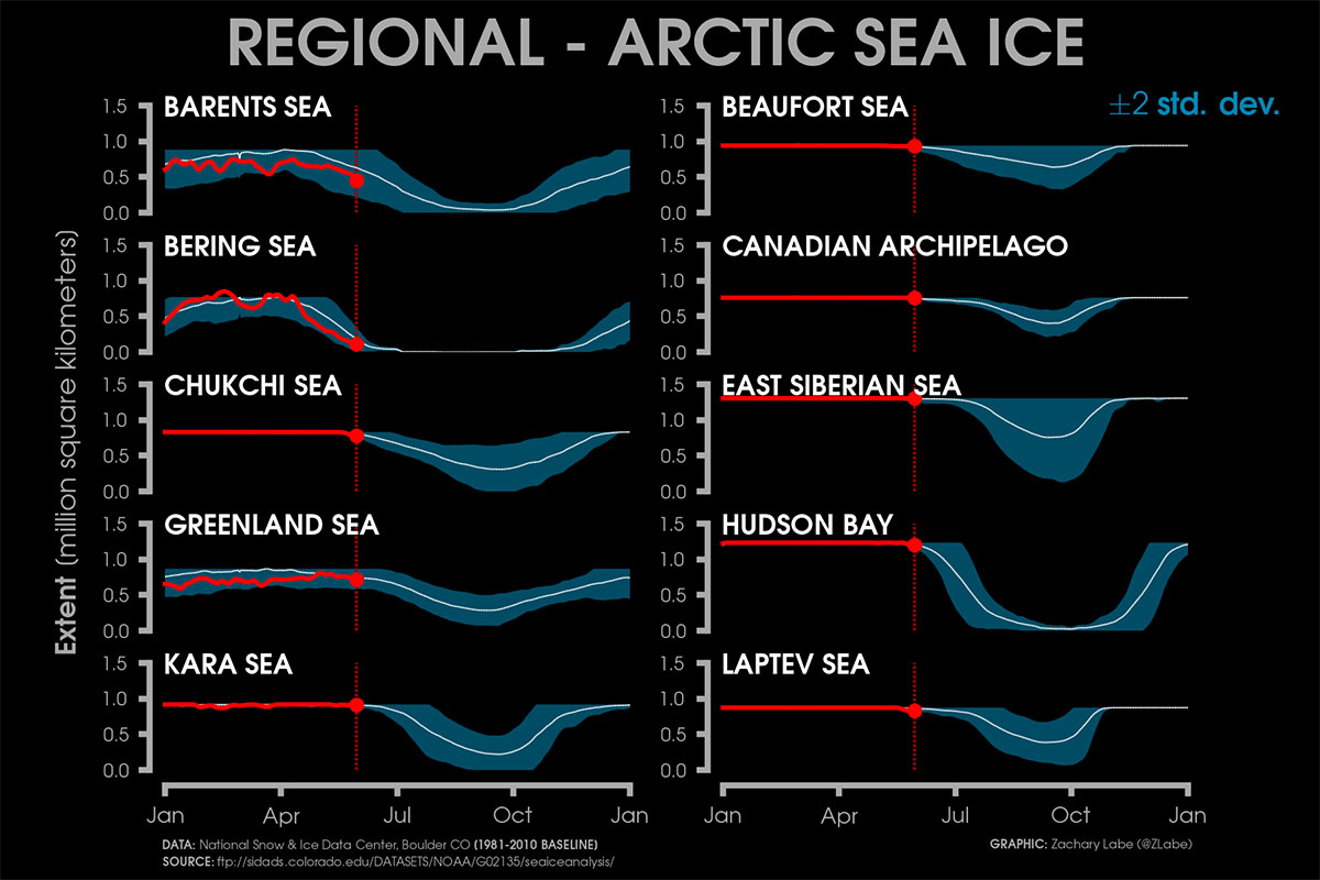
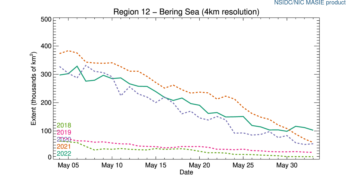
Sea Ice Extent remnants in the Bering Sea continue to melt away. The current extent is around 100 thousand square kilometers, the highest for the last 5 years according to the NSIDC. The ice melt was rather constant, apparently slowing in the last week and following the pattern of 2021 and 2020.
Sea ice extent in the Barents Sea is higher than usual in the last 5 years as it was for the entire month of May, as well as for the entire 2022 so far, especially between March and April. The present extent is around 350 thousand square kilometers following the melting pattern of the previous years

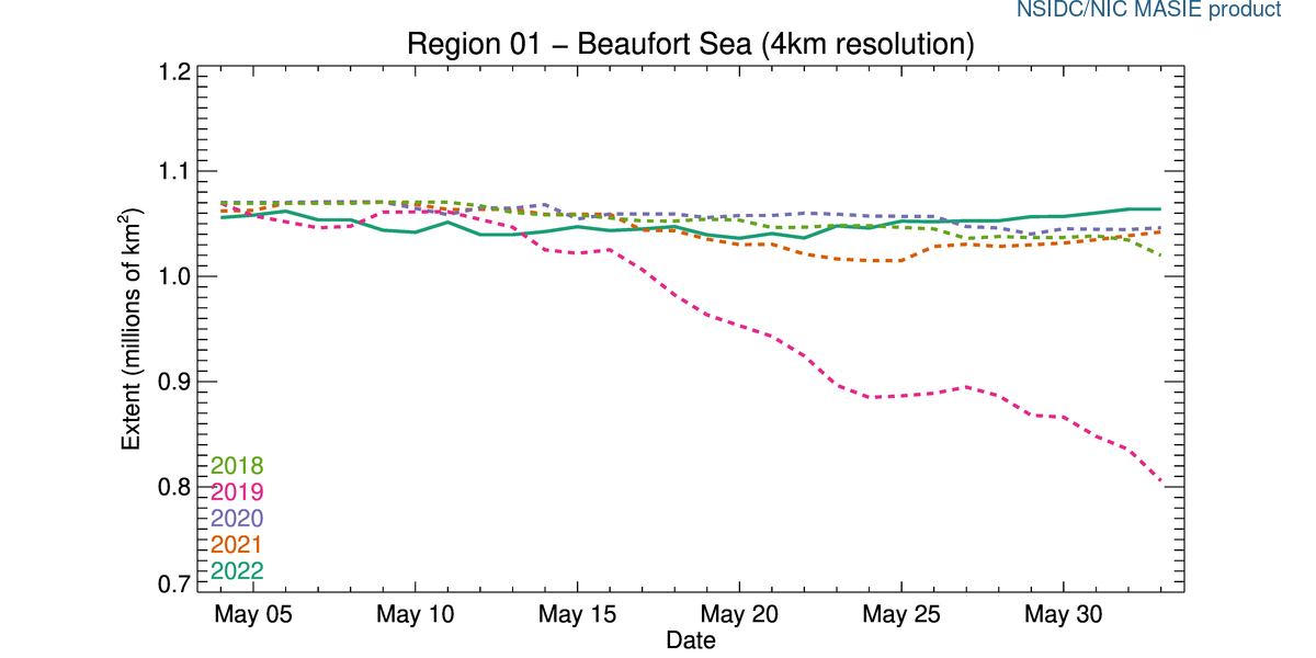
Sea ice extent in the Beaufort Sea is also higher than usual in the last 5 years at about 1.07 millions square kilometers.
In the image below the 2022 green line of Sea Ice in the Beaufort Sea is rather different from the usual trend observed in the very last years. It goes stable until May 20th before starting growing into the end of the month.
In the Laptev Sea things went much different than usual. After an abrupt sea ice decline started after the first half of May, sea ice extent started growing again from 790 to 880 thousand square kilometers.
In the image below the 2022 green line of Sea Ice in the Laptev Sea is completely different from the normal trend observed in the last 5 years, although a weak growth was also reported in 2020 in the same period.

In the Canadian Archipelago, the Sea Ice extent remained rather constant through the month of May without decreasing with the typical trend observed in the most recent years.
The present extent is around 850 thousand square kilometers, which is definitely higher than what has been observed in the very last years. In the image below the 2021 green line of Sea Ice extent in the Canadian Archipelago.

HOW WAS THE SPRING IN THE ARCTIC
Sea ice in Spring declined slower than usual this year, especially at the beginning of April, with only 87,000 square kilometers (33,600 square miles) of ice loss between April 1 and April 10. The decline then advanced at a typical pace for this time of year through April.
The average Arctic sea ice extent for April 2022 was 14.06 million square kilometers (5.43 million square miles) which is 630,000 square kilometers (243,000 square miles) below the 1981 to 2010 average. This was the eleventh lowest sea ice extent in the 44-year satellite record.
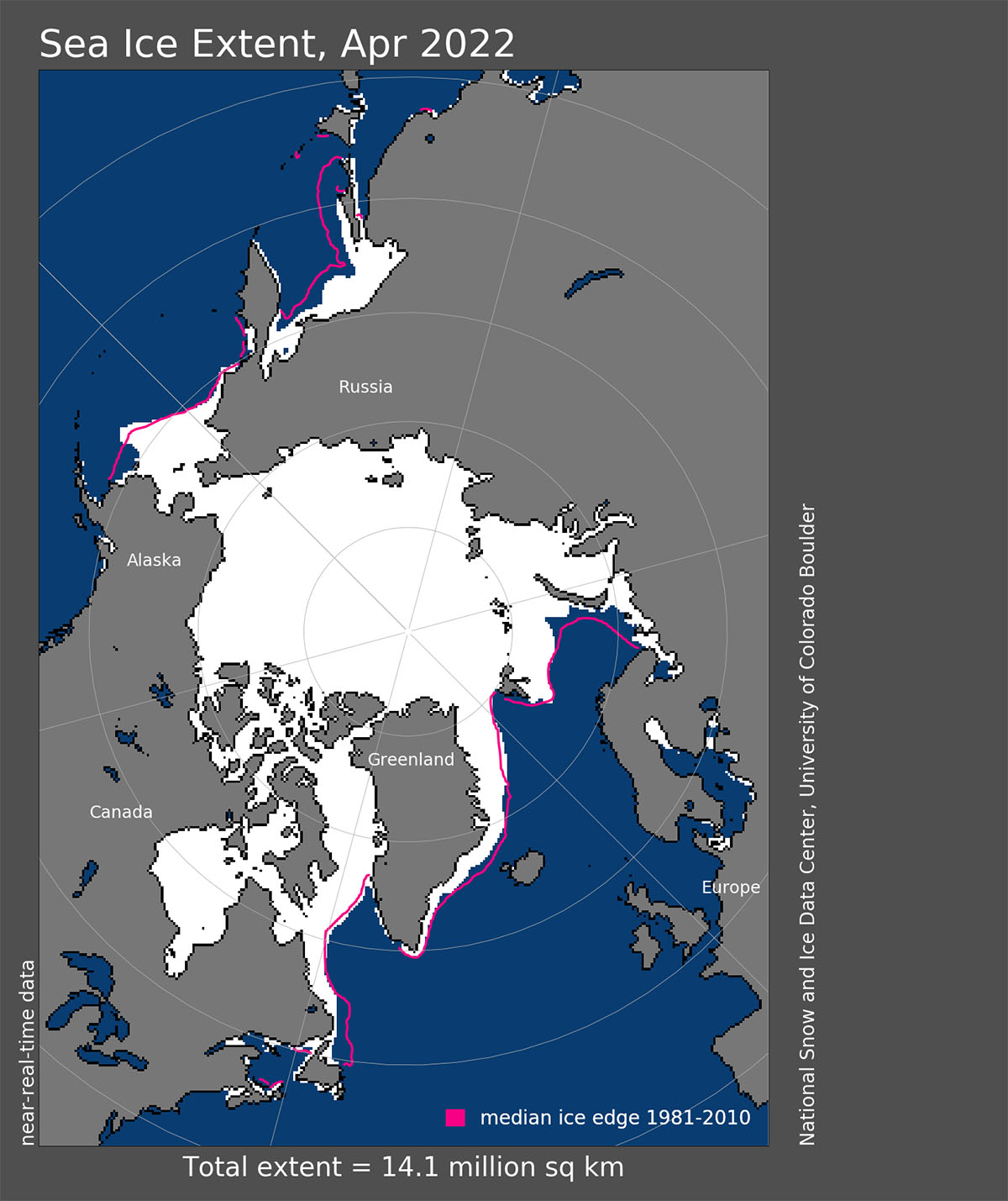
The southern Barents Sea lost some ice, but the channel of open water north of Novaya Zemlya that persisted for much of the winter closed during April. Overall, the daily sea ice extent tracked just below the interdecile range (below 90 percent of past daily values) for the month.
The interdecile range is a measure of statistical dispersion of the values in a set of data. This means although below average, it is actually within the normal sea-ice inter-annual variability. The magenta line in the image above shows 1981 to 2010 median ice age extent for April.
The general weather pattern last winter was strongly influenced by an unusually strong polar vortex. The Polar Vortex during February and in early March is generally very intense and cold. However, the most intense part of its southern lobe shifted from North America toward Asia and Europe in early March 2022.
Temperatures in the core of the lobe from -65 to -75 °C were detected, which is extremely cold even for these levels and especially for early spring. Temperatures on the other side of the vortex, precisely above Canada and Greenland, were extremely warmer, and the temperature anomaly there was around 30 degrees Celsius above normal for mid-March which is pretty extreme. Both together formed a massive dipole pattern over the northern hemisphere.

Through May, sea ice extent was tracking above levels not seen since 2013. The relatively high general ice cover for this time of the year was mostly the result of lower than average temperatures in the Baffin Bay.
According to the report published by the NSIDC on June 6th, northerly winds also slowed the retreat of ice in the Bering and Barents Seas. Air temperature at the 925 hPa level (about 760 meters or 2,500 feet above the ground) was close to average over most of the region in May, and 1 to 5 degrees Celsius (2 to 9 degrees Fahrenheit) above the 1981 to 2010 average along the coast of the Kara and East Siberian Seas, the East Greenland Sea, and the Canadian Archipelago
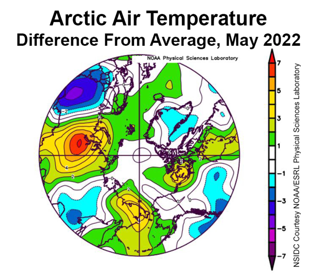
The image above credit NSIDC courtesy NOAA Earth System Research Laboratory Physical Sciences Laboratory shows the departure from mean air temperature in the Arctic at the 925 hPa level, in degrees Celsius, for May 2022. Yellows and reds indicate higher than average temperatures; blues and purples indicate lower than average temperatures.
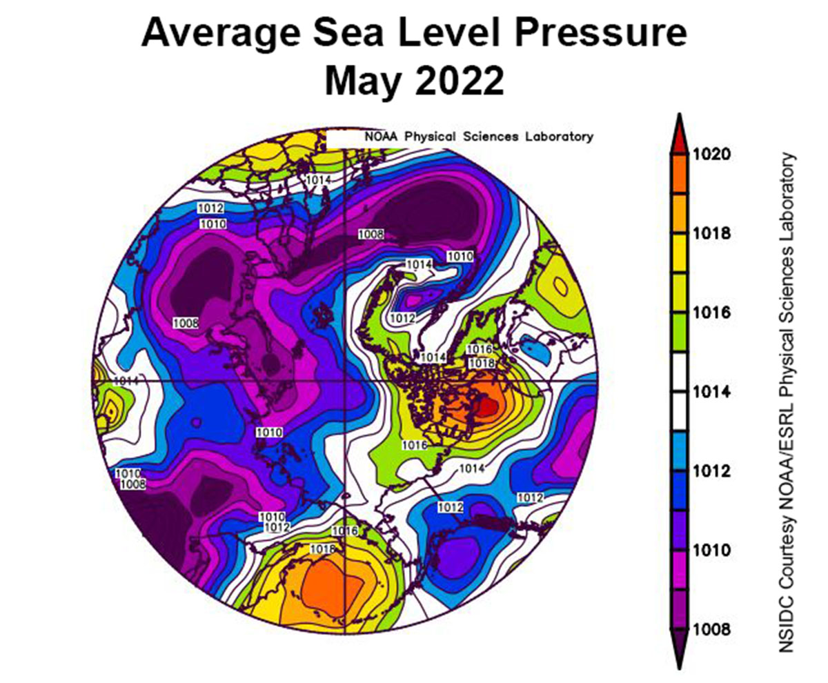
The image below (same credits as the image above) shows the mean sea level pressure in the Arctic in hPa for May 2022. Yellows and reds indicate high air pressure; blues and purples indicate low pressure.
Areas, where openings formed within the ice cover, were dominated by off-shore ice motion, pushing ice poleward as well as toward Fram Strait. The offshore ice motion was largely driven by a pattern of low sea level pressure over Eurasia coupled with high pressure over the Pacific sector of the Arctic.
HOW COULD BE THE WEATHER IN THE ARCTIC IN SUMMER 2022
Seasonal forecast focuses on several different parameters, mainly how large-scale pressure systems and the jet stream positioning trigger the weather pattern. Over the Northern Hemisphere, this upcoming Summer season will be under the influence of a cold ENSO phase called la Nina, and we talked about this a while ago when forecasting the possible summer 2022 scenarios.
When trying to diagnose any weather season and the long-range forecasts, we have to bear in mind many of the global drivers that define it. Global weather is a very intricate system, with several large-scale and small-scale aspects.

How all these factors will interact resulting in one kind of pattern or the other is a difficult task. Nevertheless, if it is well known as the most typical winter effect of a cold ENSO is a blocking high-pressure system in the North Pacific influencing the polar jet stream over the northern hemisphere, it is yet not clear how la Nina might influence the Summer.
We also have to say that, from what has been observed in the recent past, most of the temperature anomalies observed in the atmosphere in the Arctic occur in the cold season rather than in the summer.
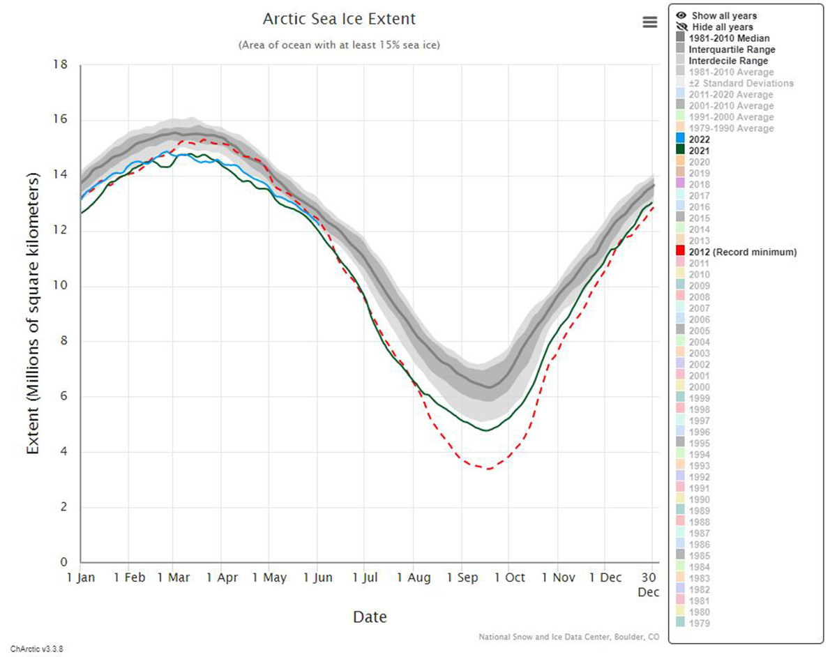
Generally, from the beginning of June, the fastest phase of sea ice melting begins in the Arctic. This is the period when sea ice extent loses approximately 2 million square kilometers of area in a matter of just 4 weeks.
To see how might be the weather in the next weeks and months we have a look at long-range climatological models CanSIPS 2 and CSFv2. The first one is based on the 1981-2010 climatology while the second is on the 1984-2009 climatology

Both models suggest close-to-normal or even cooler 2-meters temperature for most of the Arctic Ocean in June. Such a forecast hint to a likely slower than normal melting season in the first part of the Summer. The trend observed during the month of May shall thus possibly continues through the first summer month.
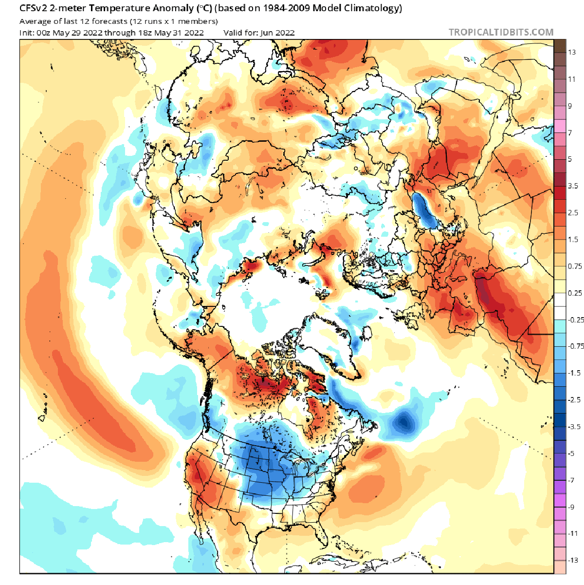
What is also clear in both models is that the Arctic coasts will likely face an increasing positive temperature anomaly through the months of July and August. The reduction of sea ice extent will be in fact more extensive in the most external portion of the Arctic Ocean as usually happens.
This aspect will foster positive feedback due to the presence of open water and the insistent solar radiation capable of heating the water body in these areas. This effect, called also Arctic Amplification, is forecasted more intense in August by the CFSv2 model as highlighted in the image below. Temperature anomaly exceeds 7-8°C in some areas.

Arctic Amplification refers to the enhancement of near-surface air temperature change over the Arctic relative to lower latitudes. Temperature and sea ice-related feedbacks are especially important for Arctic Amplification since they are significantly more positive over the Arctic than at lower latitudes
Suggested mechanisms leading to the observed Arctic amplification include Arctic sea ice decline (open water reflects less sunlight than sea ice), atmospheric heat transport from the equator to the Arctic, and the lapse rate feedback.

Looking at the long-term trends we can see how the sea ice anomaly is apparently following a weak recovery although in 2021 the minimum sea ice extent of all times has been observed.
Actually, according to data from the National Snow and Data Center of Boulder the sea level extent anomaly is approaching zero. Nevertheless, except for a very short period in 2012, 2010, and 2009 the anomaly was always negative from 2003.
We will keep you updated on this and much more, so make sure to bookmark our page. Also, if you have seen this article in the Google App (Discover) feed or on social media, click the like button (♥) to see more of our forecasts and our latest articles on weather and nature in general.
