A Volcanic eruption is becoming likely in Iceland after over 4000 earthquakes have struck the southwestern parts of the country. Together with GPS and satellite data, it shows that magma is rising to the surface, with an eruption likely just days away now.
The latest data shows that magma is just around 450m (1500ft) below the surface and rising. This has prompted the officials to raise the alert level to orange and evacuate almost 4000 people from the area.
FIRE AND ICE
There is usually a volcanic eruption in Iceland every 4 to 6 years. The last eruption was actually a series of three events. After 800 years of dormancy, the Fagradalsfjall volcano erupted in March 2021, August 2022, and July 2023.
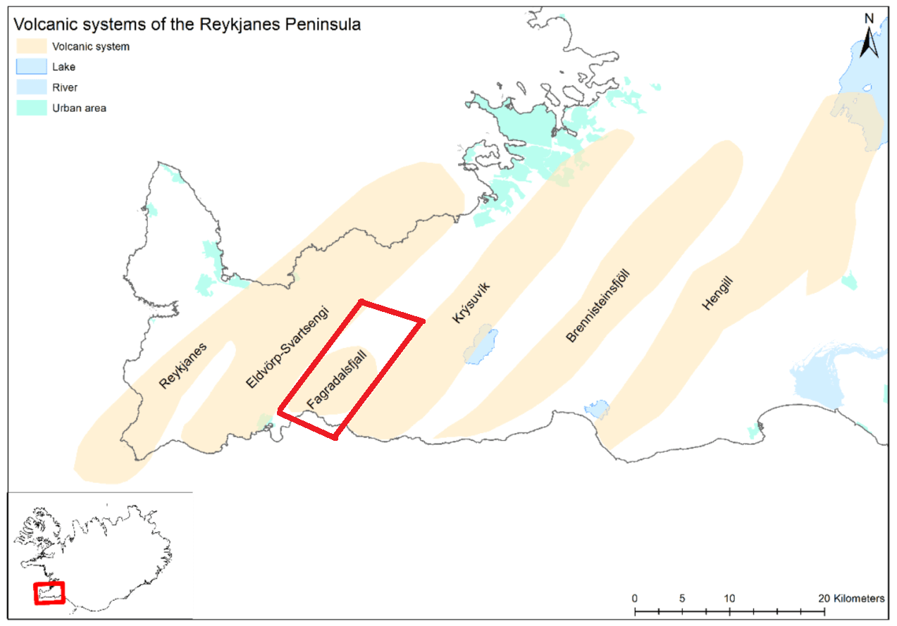
The style of this eruption series was a lava flow from the Fagradalsfjall volcanic area. The eruption area is found on the Reykjanes Peninsula in southwest Iceland, as seen in the image below by the Icelandic Meteorological Office (IMO).
Below is an image of the lava field during the eruption in 2021. The eruptive cones were glowing red, while the erupted lava was already cooling and turning dark in the process. Photo by: Almannavarnir/Björn Oddsson.

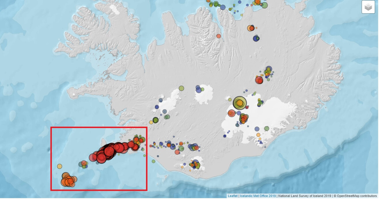
The latest round of very strong seismic activity is also found on the Reykjanes Peninsula in southwest Iceland, but further to the west than the last eruption.
UNUSUAL SEISMIC ACTIVITY 2023
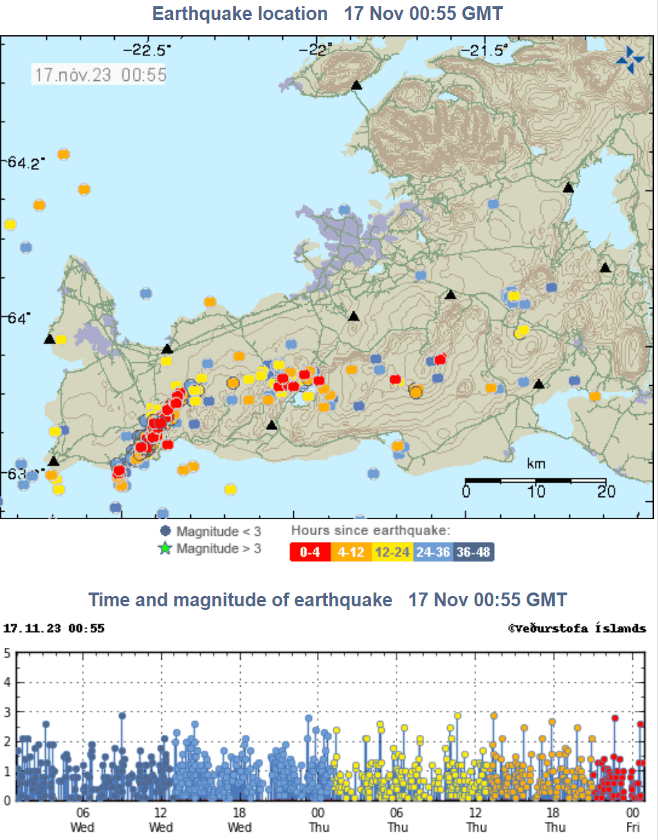
The latest round of increased earthquake activity began around October 25th in southwestern Iceland. You can see the earthquake locations since that day in the image below. Strong activity can be seen in the southwest.
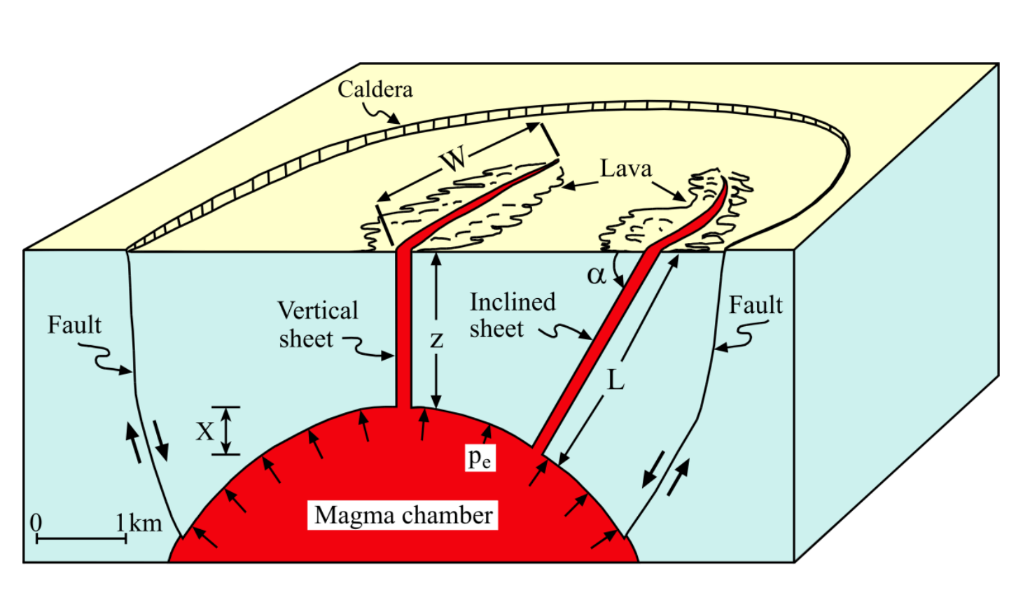
The reason for this activity, and over Iceland in general, is a combination of plate tectonics and magma movement. There are many fissures below ground in this part of Iceland.
In the image below, you can see the main driving force behind these events: the spreading of the North American and Eurasian tectonic plates. These forces literally tear the ground apart as the plates move in opposite directions. The empty space between the plates is usually filled with magma rising from the Earth’s mantle.

This process is roughly outlined in the schematic below, as the magma rises up from the formed cracks and fissures in the ground. The narrow vertical cracks that get filled with magma are called dikes or dykes. They are usually narrow and quite linear in shape.
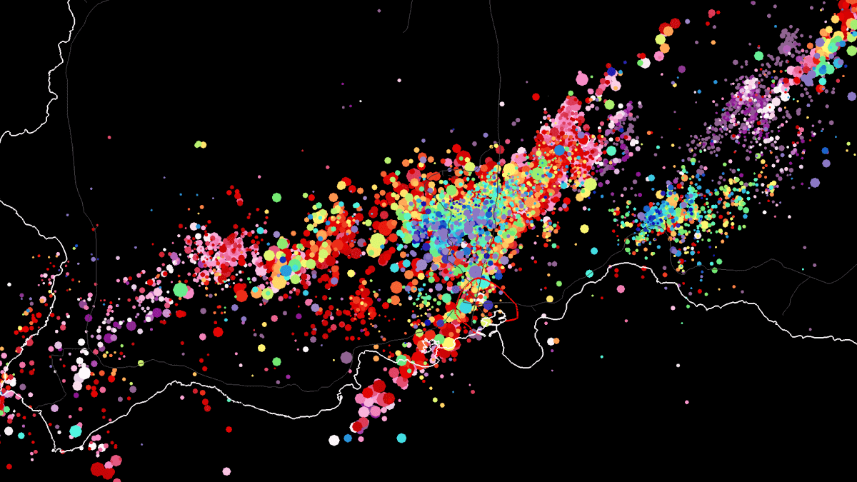
You can see a dyke by looking at the earthquake data over southwest Iceland for the past 30 days. A narrow and very linear pattern of earthquakes, “cutting” across the region. These earthquakes occurred at a depth down to around 8km (5 miles).
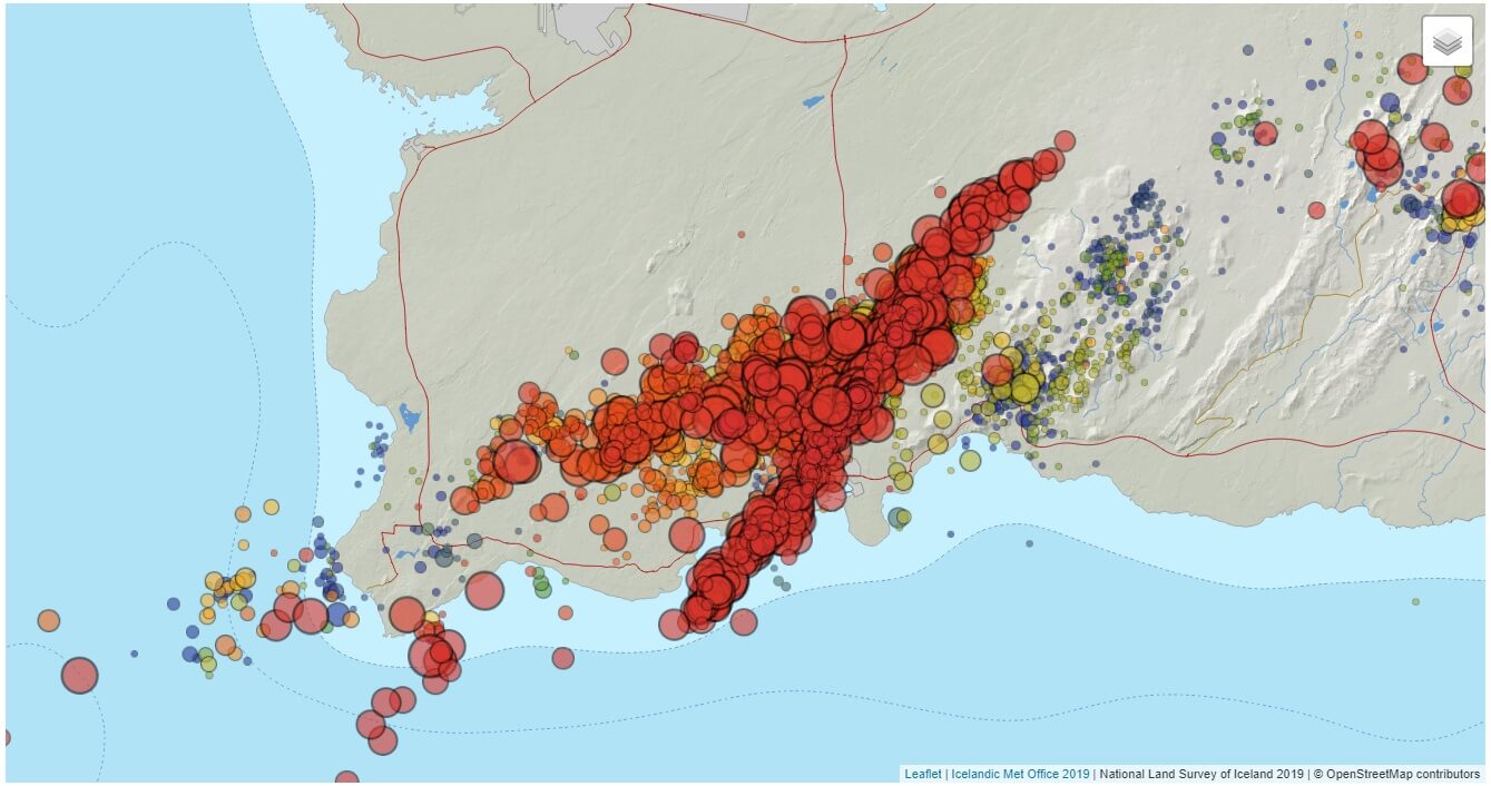
Since the beginning of the event on October 25th, there have been over 4000 earthquakes in the area. Many earthquakes were above magnitude 4, with the strongest events around magnitude 5. Due to their shallower depth, they were felt far around the area.
The next image shows all the earthquakes in the database from June to November 2023. The main area of interest is the town of Grindavik, which is marked by the red circle in the image. You can see a line of earthquakes (dyke) running directly across the town.

We produced a special video that shows all the earthquakes from October 25th, as the event began, until November 15th. You can see how many earthquakes were added daily, with the strong (linear) dike formation around the 10th.
It also shows the earthquakes being focused mainly along the dike in the past days and under the town of Grindavik (red-marked area). Overall, the officials deem the eruption more a question of “when” rather than “if”.
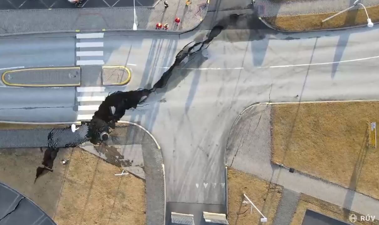
You can see these forces in real life in the image below. It shows a large ground crack running through the town of Grindavik that is directly on top of the earthquake activity. The cracks form mainly due to ground motion and rising magma from below. Image by Ragnar Visage via RUV.
WHEN THE GROUND MOVES
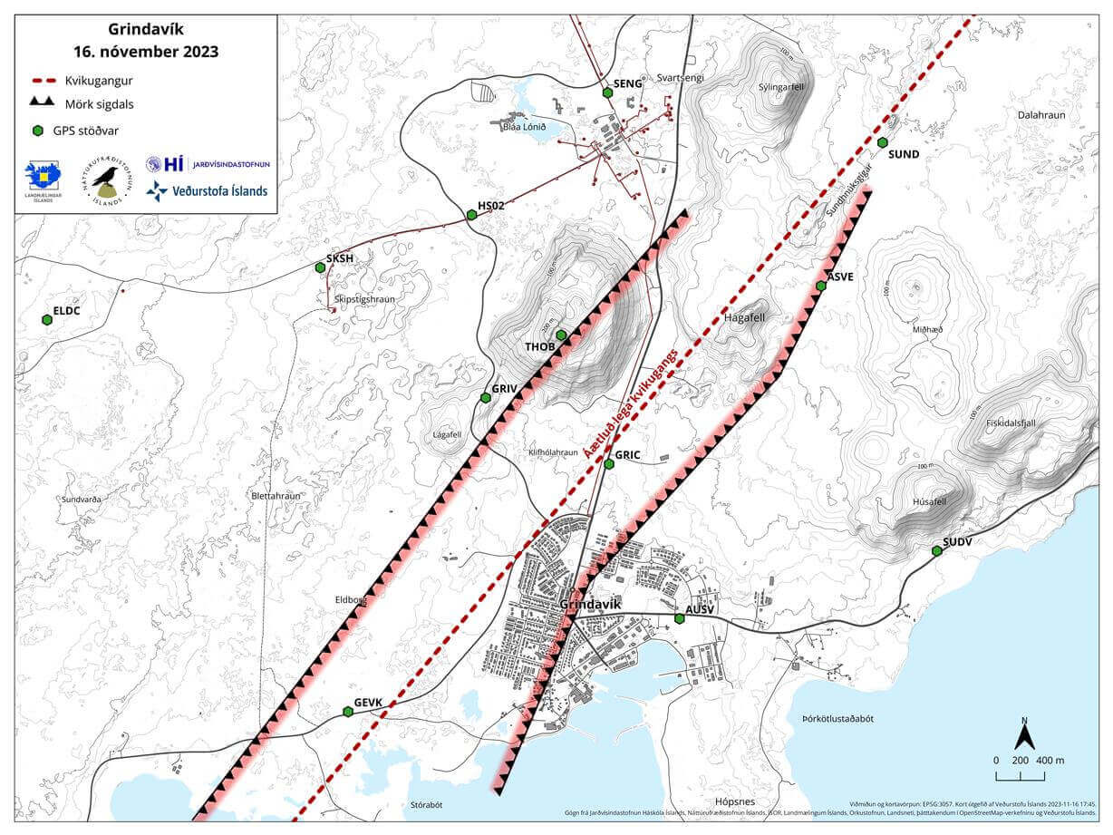
The official analysis of the area in the image below shows the outlines of the dike running directly across the town of Grindavik, causing large cracks in the ground. Almost 4,000 people were evacuated from Grindavik over the weekend due to the fear of an imminent eruption in the area.
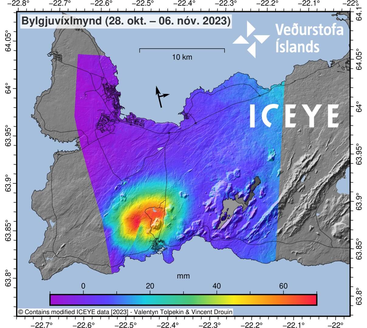
But how do we know that there is magma rising to the surface? One part of the question is the type of earthquakes and their pattern. The second part of the answer is ground motion. When magma rises to the surface, it causes a lot of noise and a lot of ground motion.
Below, you can see the estimate of the vertical motion caused by the dike last weekend. The cold colors indicate the ground dropping/subsiding over 1 meter (3ft) just west and north around the town of Grindavik. This is caused due to the dike pushing the ground apart, which drops it down in the middle.

From all the combined data, scientists can calculate the approximate volume and depth of the rising magma. That way, we can roughly estimate where the magma is, how fast it rises, and how much there is. What we can’t tell is when it will erupt onto the surface.
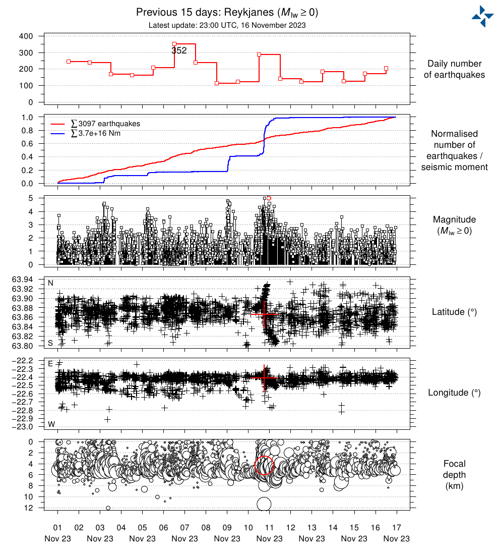
The latest 48 hours of earthquake data show continued activity, with several hundreds of daily earthquakes. Below, you can see the sharp linear shape of earthquakes in the southwest, which is called a dike, where the magma rises to the surface.
There are many seismographs in this region, so monitoring is excellent. Below is a seismograph reading from the Grindavik area, close to the activity. You can see many earthquakes, down to the micro-seismicity, that reveals near-constant activity.
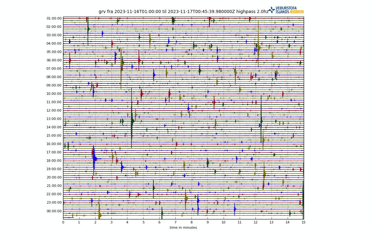
Most of the earthquakes are detected in the middle of the magma dyke at Sundhnúk at a depth of about 3-5 km. Seismic activity has remained constant since the 11th of November. The main monitoring focus on seismic activity remains in the area of the dike and Grindavik town.
Measurements of sulfur dioxide (SO2) show the presence of magma at shallower depths. SO2 is a volcanic gas, and the closer the magma gets to the surface, the more gas escapes the magma and can be measured at the surface. That indicates the magma is rising.
Below is a special plot showing the shaking frequency and tremor intensity around Grindavik. You can see the strong volcanic tremor around the 10th of November when the dike made a major advance under the town.
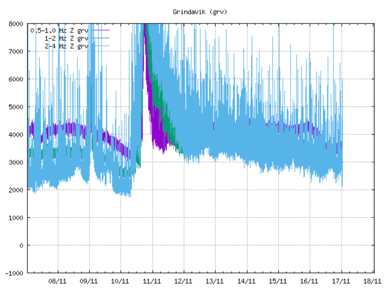
The tremor above looks to be reducing with time, as are the earthquake magnitudes. But that can be deceiving. It can actually indicate that the magma is nearing the surface, where the rock is different, and where the ground is already cracked from past earthquakes.
ERUPTION GETTING CLOSER
With the increased seismic activity and ground deformation, the volcanic system on the Reykjanes peninsula was raised to an orange alert level by the IMO. An orange alert is issued when a Volcano exhibits heightened unrest with an increased likelihood of eruption.

Based on the latest activity, the eruption is said to be just days away. It is currently estimated that the magma is just 400-500 meters (1500ft) from the surface.
It is not clear where exactly an eruption could break out. The magma usually follows the path of least resistance, so it can be anywhere along this dike that formed. It is estimated that the most likely place for an eruption is just west to northwest of the town.
The most likely eruption scenario is a large lava flow, with eruption cones over a greater distance. There is a very small chance that this eruption would also produce an ash cloud.
Let’s not forget in 2010, a strong eruption in Iceland produced a large ash cloud that halted the entire air traffic over Europe and surrounding regions. It left thousands of people stranded and created financial losses in the billions.
As the eruption can occur anywhere along the dike, it can also, in theory, start in the ocean as the dike extends below the water. If that were to occur, then the combination of lava and water could create an ash cloud.
A lot depends on the composition of the erupted material and how deep beneath the water it is. A shallower event can generally create a larger ash cloud, while a deeper eruption can be more contained by the weight of the water.
We have produced an image that calculates the potential ash cloud dispersion if the eruption occurs on the 18th. The data shows that a potential ash cloud would move directly over northern and western Europe.
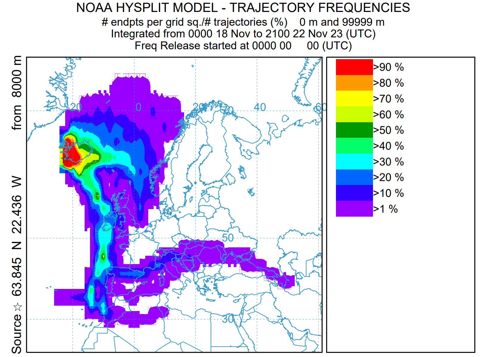
A scenario like this would very likely close the airspace over much of Europe.
An eruption is not yet certain at this point, but the longer the earthquake activity continues, the higher the chance of an eruption becomes.
There is also a possibility that the earthquake activity could slowly reduce, ending with no eruption.
We will release updated articles as fresh data is available and more reliable projections can be made.
DON’T MISS: