As the meteorological Fall is coming to an end, the cold air outbreaks tend to get more frequent. A pressure pattern change will bring a substantial release of colder air across the United States around Thanksgiving and till the end of the month.
Strong pressure changes are normal as we slowly get closer to the Winter season. This month will be a good example of how a pressure pattern change can bring strong temperature changes across the United States.
After an unusually warm start to this week, a rising Pacific ridge will bring a low-pressure anomaly and colder temperatures across much of the Midwest and the northeastern United States going into next week.
AUTUMN COMES AND GOES
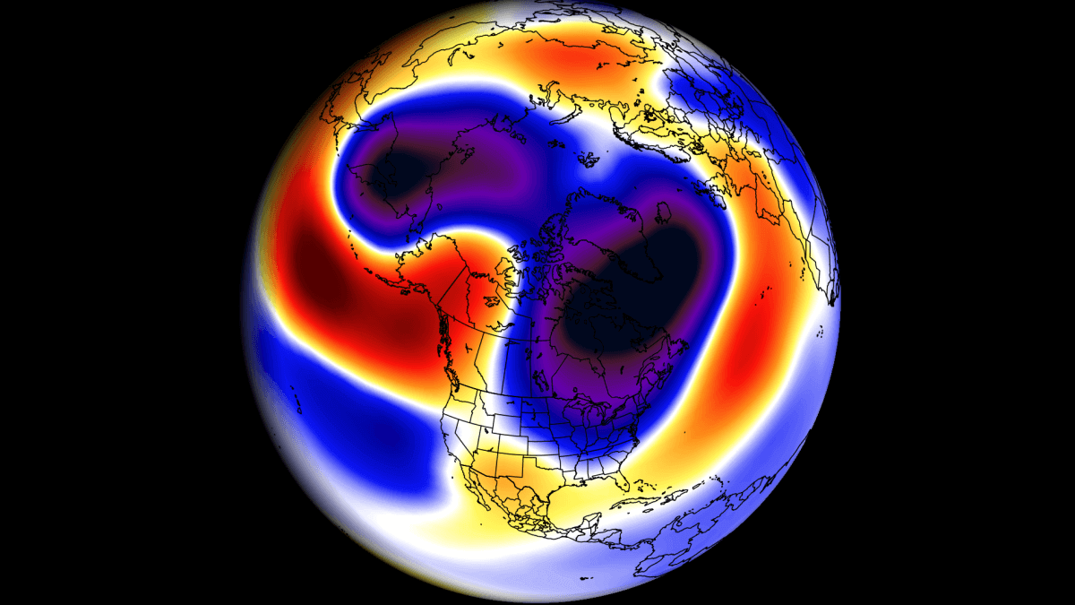
Before going into the forecast, we will quickly examine how the Autumn season has developed so far. Below is the pressure anomaly analysis for the September-October period. This covers the first two months of meteorological Fall.
The most obvious feature of the Autumn season so far was a high-pressure system over eastern Canada and the northern United States. A low-pressure zone is seen in this 2-month average over the eastern United States and the west coast.

But keep in mind that this is a 2-month average. So, while it shows the prevailing weather patterns, it can hide quite a bit of variability.
Looking at temperatures for the same period, you can see mostly above-average temperatures across the United States and Canada. Normal seasonal temperatures were recorded in the southeastern United States, the west coast, and over Alaska.

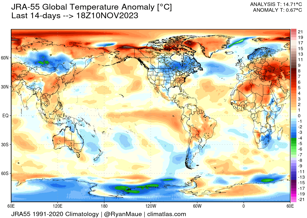
But looking at the early November, the pattern has been different. The image below shows the colder-than-normal weather over the Northern United States, the Plains, and southeastern Canada in the past 14 days.
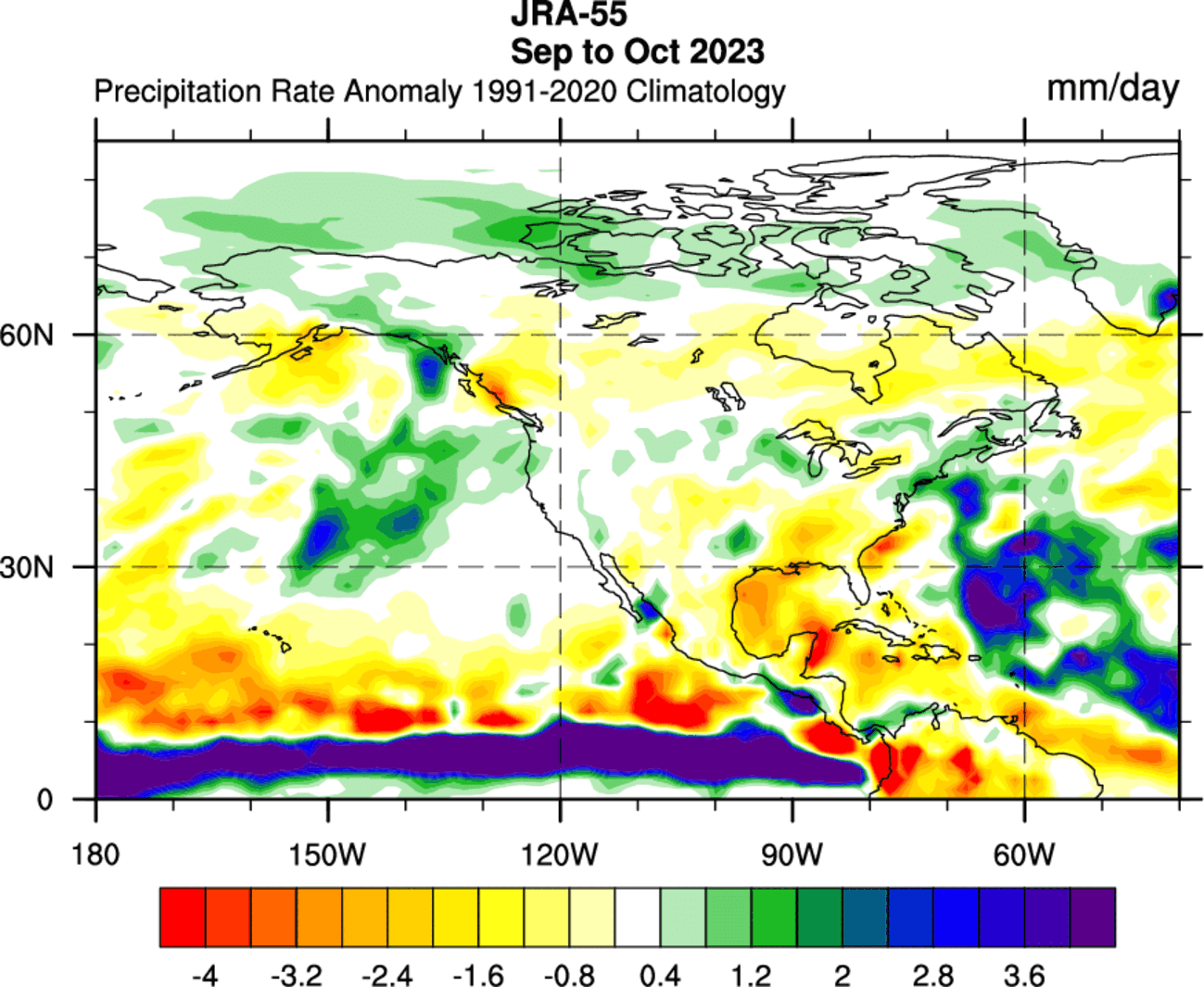
Looking at precipitation for September and October, more rainfall was recorded over the west coast of the United States, across the northern United States, the Northeast, and the southern Plains. Drier conditions were seen across the southeastern United States, central Plains, and central Canada.
But the final month of the meteorological Fall will bring quite a rollercoaster of weather patterns across North America, starting with warmth and ending with cold.
The video below shows a quick recap of the latest GFS model run. It shows the snow depth forecast for the next 16 days, where you can see the changes in snow depth and expansion across the northern United States, following dynamic weather patterns.
There is a very noticeable snow cover expansion across the upper Midwest and the northeastern United States around the Thanksgiving holidays. Another expansion follows into the final days of November across the upper Midwest and the northeastern United States.
But we will now take a closer look at the coming weeks and how the weather patterns are forecast to evolve across North America.
NOVEMBER WEATHER FORECAST
Going into the forecast, we have the pressure pattern forecast for the next few days below. The main feature is the high-pressure ridge across the United States. Another feature is the low-pressure system just off the west coast.

Combined, the low-pressure system and the U.S. ridging help to push a warm westerly to southerly flow across the United States. Another feature is a low-pressure zone over Canada, which will reach the United States later in the week.
The temperature forecast for the same period reveals a strong warm air anomaly across much of the central and northern United States and southern Canada. This combined effect of the ridge and the low-pressure zone marked above creates a strong warm anomaly.

California can be seen with cooler anomalies extending into the state from the Pacific due to the low-pressure system moving in.
Looking specifically at Thursday, it is forecast to feature the strongest warm anomalies across the Northern Plains. Cooler conditions than usual will prevail over the Pacific Northwest and parts of the southeastern United States.
Looking at precipitation, there are mostly drier conditions forecast for the next few days across the eastern and northwestern United States and southern Canada. More rainfall is expected across the southeast U.S.
 But a different weather pattern is starting to appear in the trends, with a weather change around Thanksgiving for the Midwest and the eastern United States.
AS WEATHER PATTERNS CHANGE
Going into the Thanksgiving week, the pressure pattern will be quite different. A ridge will start to rise over the northeast Pacific and Alaska, also spreading over western Canada. That will help to push a low-pressure zone down into the northern and later eastern United States.

The temperature forecast shows a different pattern, with a cold anomaly over the eastern United States and a warm anomaly still lingering over the western United States. But this is a 5-day ensemble forecast average, which hides the true extent of the cold air intrusion.

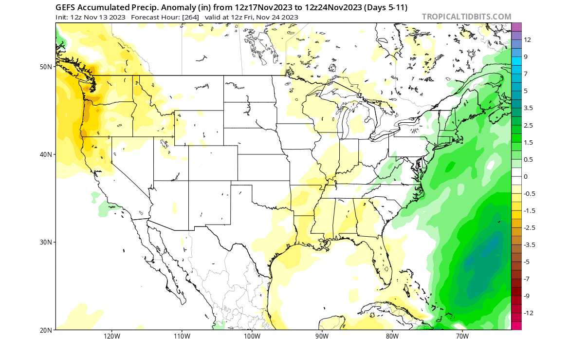
In this period, the precipitation forecast shows drier conditions across the Pacific Northwest, while most of the central United States has a normal precipitation forecast. More precipitation is forecast across the northeastern United States.
EASTERN UNITED STATES COLD WAVE
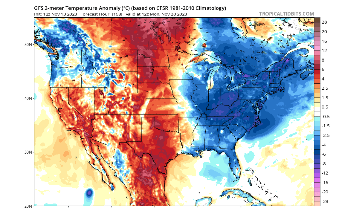
Below is a surface temperature anomaly forecast for the 20th of November by the GFS model. You can see much colder than normal surface temperatures across much of the eastern United States. The Plains and the southwestern parts of the U.S. will remain warmer than normal for now.
At this range, it’s good to look at different model solutions. Below is the ECMWF forecast for Thanksgiving day shows even stronger surface air anomalies. The warmer air is left further out over the west, while the central and eastern United States are under unseasonably low temperatures.

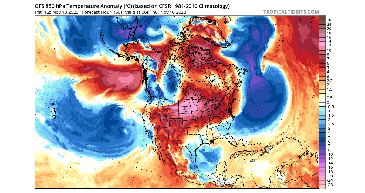
The image below shows the ECMWF temperature forecast for Thanksgiving, but it shows the airmass temperature anomaly at 850mb pressure level (1500m/5000ft). It shows a strong cold air outbreak across the Midwest and the eastern United States, also reaching the southern states.

Below is the 10-day snow depth change forecast from the GEFS ensemble system. It shows the change from today to the Thanksgiving. You can see a snow depth increase across the northern Rockies and western Canada.

But you can also see a snow depth increase across the upper Midwest and the northeastern United States. This is just an ensemble mean forecast, and we will look closer at this event with more detailed snow maps as the event approaches.
AUTUMN ENDS, COLD PERSISTS
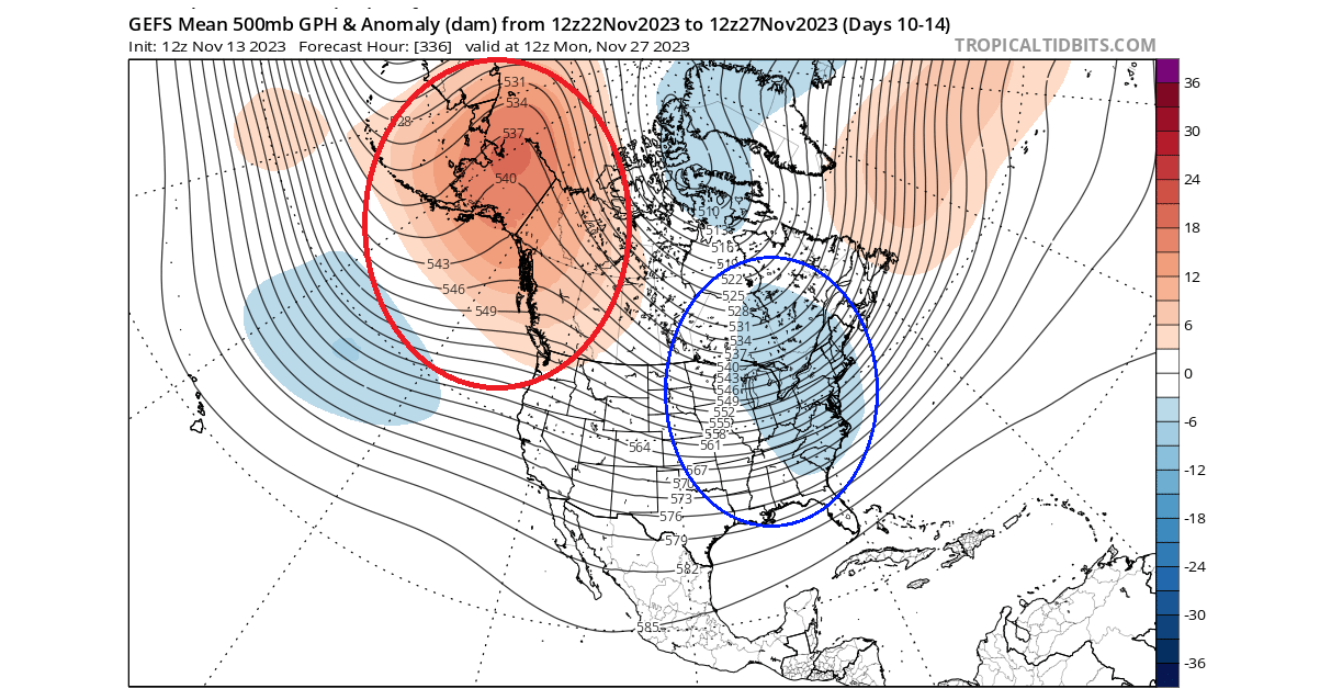
The pressure pattern will persist going into the final days of November and meteorological Fall. You can see ridging over western Canada and Alaska and low-pressure over the eastern United States and eastern Canada.
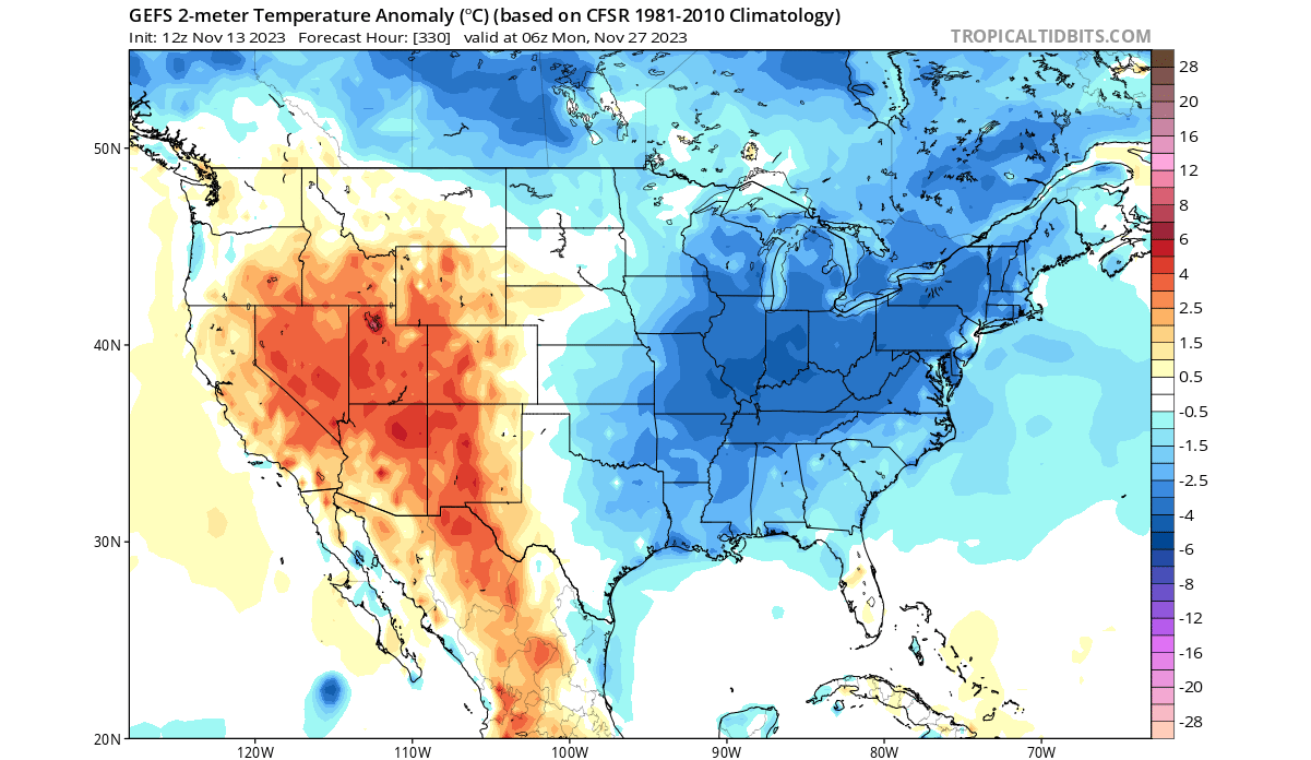
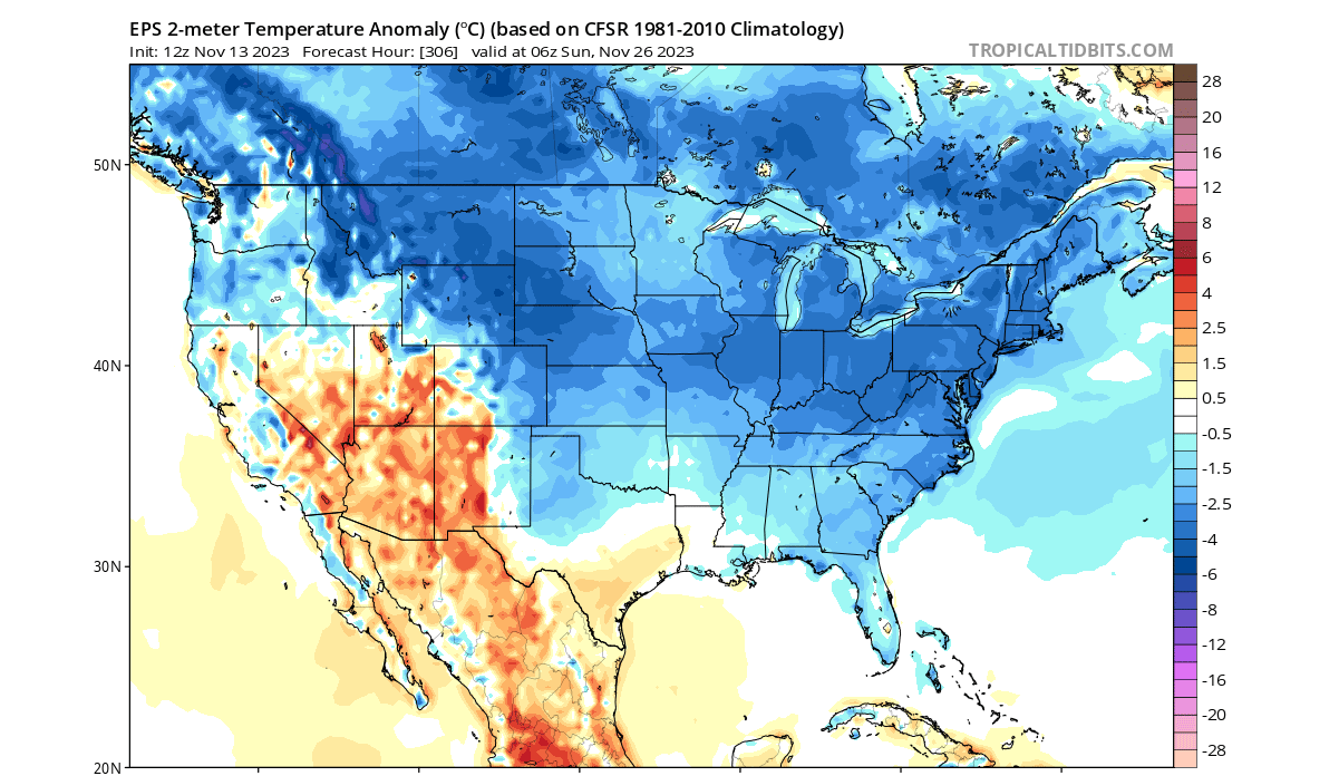
Looking at the temperature anomalies in this period, you can see a more widespread cold anomaly signal. The colder-than-normal temperatures are forecast to cover most of the United States, except from the southwest.

The surface temperature forecast below for the 27th of November shows a clear east-cold, west-warm pattern. This is driven by the low-pressure anomalies over the eastern United States, bringing down a more northerly flow over the east.
Also, looking at another model, again the ECMWF, you can see a very similar temperature forecast. Colder than normal air will be present over much of the United States in the final week of November. The exception in the ECMWF is also the southwest.
The snow depth forecast below shows the snow depth change from Thanksgiving to the 29th of November. You can see an increase in snow depth across the northwestern United States and the higher elevations of California.

There is also a snow depth increase across the upper Midwest and across the northeastern United States. As temperatures fall seasonally, you can also see a widespread snow depth increase across most of Canada.
NOAA WEATHER FORECAST
Below is the official NOAA temperature outlook around this same period. It shows the colder anomalies in the western and northern United States, reaching into parts of the Midwest. The Eastern United States is shown to be slightly warmer than normal.

This is perhaps not the best forecast at this moment, as it is not updated as regularly as the models are. And it usually takes a longer time to adjust to the latest trends. Also, the timing of the 8-14 day forecast is perhaps too early to fully cover the late month period.
In the coming days, we expect this outlook to adjust to colder conditions across the Midwest and the northeastern United States.
The precipitation forecast shows mostly more precipitation in this period. This would explain the increased snow depth forecast, as more precipitation and cold air result in snow. But just like the temperature outlook, this also needs some time to adjust to the latest trends.

We will release regular updates as fresh forecasts and data are available. So make sure to bookmark our page. Also, if you have seen this article in the Google App (Discover) feed, click the like button (♥) there to see more of our forecasts and our latest articles on weather and nature in general.
SEE ALSO: