Half of winter is already behind us. This is usually the time when we take a first look at spring, to see what the early projections are and what to expect. We are also going to have a look at how the last winter month, February, might look.
If you are interested in the theory behind long-range forecasts, check out our first post from September, where we had a look at early forecasts for this winter and we also briefly explain the theory behind the long-range forecasts.
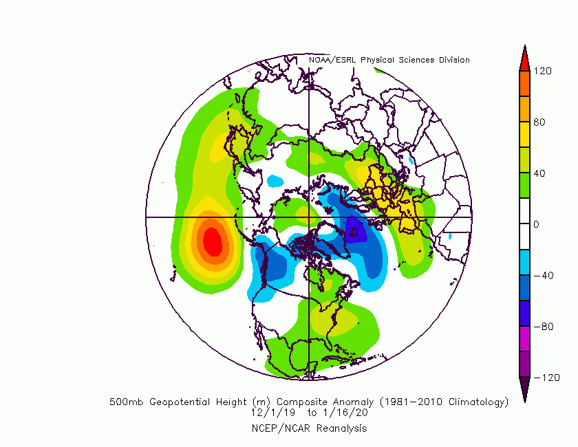
First, let’s take a look at the winter season so far since half of it is already behind us. Looking at the pressure anomalies, it is so far quite similar to what the long-range forecasts indicated. The North Atlantic was dominated by lower pressure, while Europe, parts of Asia and parts of the United States were under higher geopotential heights. The same goes for Canada, where we see higher pressure in the eastern parts and lower in the western parts. This higher pressure over the east Canadian sector, kinda shows how the main bulk of the lower pressure dominance in the North Atlantic was slightly more eastward based, as we can also see by the lower pressure extending eastward into Scandinavia.
Temperature wise, the winter so far is a perfect reflection of what to expect from such pressure patterns. We see the whole Eurasian sector being well above average, also most of the continental United States. What stands out is Alaska and the western Canadian sector, recording the most below normal temperatures this season so far. Looking more globally, Australia also stands out as a hotspot, where they were struggling with severe heat, drought and wildfires.
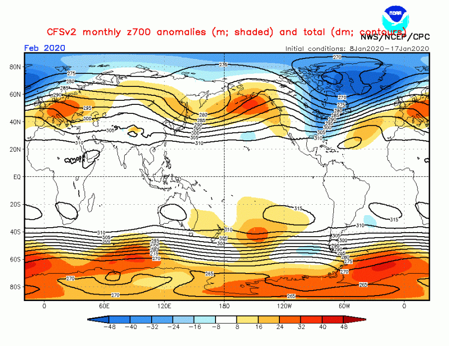
Looking at the forecasts for the last winter month, February, the same pattern does seem to continue. The difference is, that we have a ridge over western North America, which helps to extend the lower pressure down into eastern Canada and the east/central United States. That would mean colder air for east Canada and many parts of the eastern and central United States. As a contrast, such pattern development does promote further low pressure in the North Atlantic, which further helps to build and sustain higher pressure into Europe and the Eurasian sector.
Lower pressure over the east/northeast North America, means colder air transport into the continent from the north. This mainly goes for parts of eastern Canada and the central and eastern United States. As expected by the higher pressure over Eurasia, temperatures are expected to remain mostly above normal for the last winter month. This means the extension of lower probability of proper winter weather over mainland Europe in February. As always, there is a possibility for the transitional cold pattern as a cold front can mover over the European continent, but long winter periods are by current analysis unlikely. The stratosphere is still a player, as the polar vortex slowly starts to lose its strength as we head into February, but any potential strong dynamics in the first half of February would be too late to generate a sustainable high latitude blocking pattern (NAO -) by the end of the month.
SPRING 2020
For the spring outlooks, we decided to focus on the main 4 models from the EU and the USA or at least the most used ones. Graphics are from the Copernicus Climate EU project. All these forecasts are an average picture over the 3 spring months (March-April-May) and show the general prevailing weather pattern. Even if the models would be completely accurate, it does not mean that such weather conditions would last for 3 months straight. So the models don’t suggest what the weather will be like for 3 months straight, but just how it might look 40-60% of the time.
ECMWF
We always want to know how the pressure forecasts look like. That tells us a lot about the overall global circulation and weather patterns.
ECMWF continues a similar story to the winter pattern. We generally see lower pressure over the pole and in the North Atlantic, corresponding to a positive AO (Arctic Oscillation) and NAO (North Atlantic Oscillation) pattern. We see prevailing high pressure over the North Pacific, West Atlantic, and Europe. Considering the ridging over North Pacific and Western Atlantic, that could mean lower surface pressure over the Continental United States. That is indicated as a neutral zone between two positive MSLP anomalies on each side of the continent. It is perhaps an important indication for the tornado season, but more about that in a future update. A feature to look out for is the indicated lower geopotential height over Scandinavia, east into Russia. Such a pattern could promote more northerly cooler flow into far eastern Europe.
The temperature forecast is reflective of there pressure patterns, with only North Atlantic being below normal, due to fairly constant cyclonic activity, that is mixing the ocean surface, allowing the cooler deeper water to mix to the surface. Most of Eurasia is above normal, while North America is a bit more mixed. Western parts are featuring above normal temperatures, due to the higher pressure in the North Pacific. East Canada is indicated as normal since there is a chance of some northerly flow from the cyclogenesis over the Greenland sector. We see some neutral temperatures over the central USA and above normal in the east/southeast, associated with the likely lower surface pressure in the central parts, promoting warmer flow into east and southeast USA. In the South Hemisphere, we have north Australia and South Africa standing out with quite above normal temperatures. While there is spring in the Northern hemisphere, there is autumn/fall on the Southern Hemisphere.
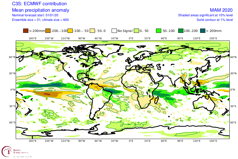
Looking at rainfall, we see south and southeast parts of the USA to be under higher than average precipitation, which corresponds to lower pressure over the central parts of the continent, which would promote more humid warmer southerly flow from the Gulf of Mexico.
In Europe, we have some drier weather over the southern parts, which corresponds to higher than usual pressure. Mainland Europe is seen to be around average precipitation values, so no serious drought conditions are expected, but that remains a possibility if the high-pressure area would be persistent or reaching further north. Lower pressure in the Atlantic does bring humidity into central and north Europe, with the prevailing westerly winds from the Atlantic.
UKMO
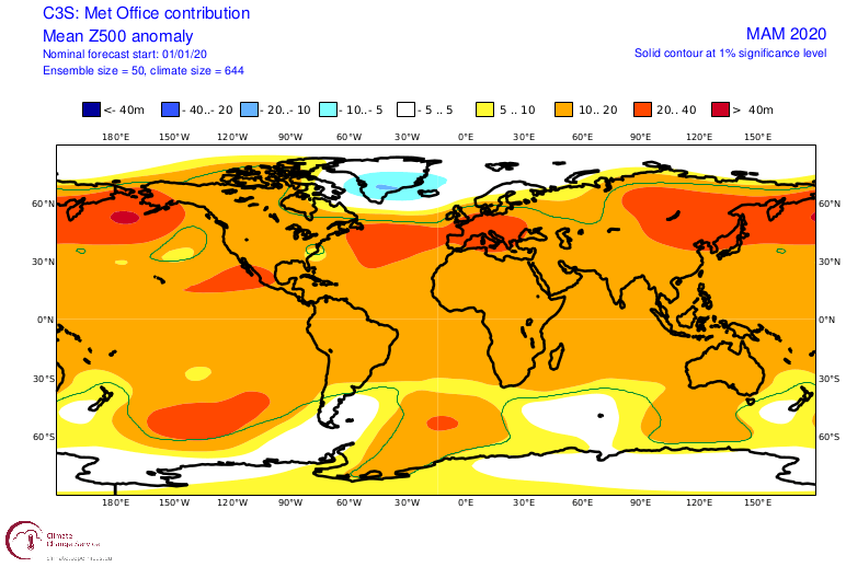
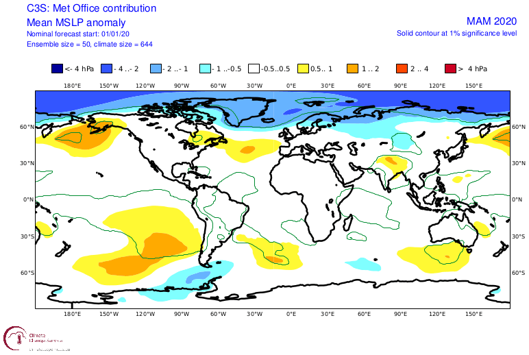
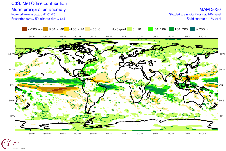
UKMO is a model from the United Kingdom Met Office. It continues in a similar way as the ECMWF. The difference is that UKMO has a bit more defined positive NAO pattern, as it has lower pressure over the North Atlantic. It has a stronger North Pacific high pressure but is not very well defined with high pressure over Europe like the ECMWF.
The temperature forecast is thus a bit different. We still have positive anomalies over Eurasia, as a natural response to positive AO/NAO, as pressure is lower over the pole. But we do see neutral temperature anomaly suggested over the eastern United States, which could be linked to the high pressure in the pacific being positioned more over the central Atlantic, easing the warm southerly flow the eastern United States that ECMWF suggests.
Looking at rainfall, we also see that since UKMO does not have such strong positive surface pressure anomalies over Europe, it does not show drier than normal conditions over southern Europe. And because the high pressure over the Atlantic is positioned more towards central area and not the western Atlantic, we have the warmer and more humid southerly flow positioned further east out of the east coast of the USA.
NCEP
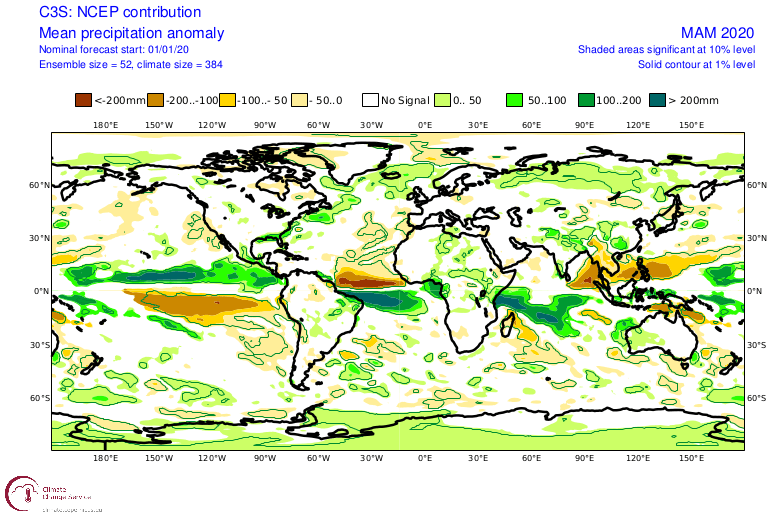
NCEP is the National Center for Environmental PRediciton. They use the CFSv2 model for their long range forecasts.
While UKMO is focused a bit more east with the low pressure in the positive NAO, the NCEP pulls it a bit more west. It has a dominant low-pressure area over the north-western Atlantic, and also high pressure positioned over the central Atlantic. But when we look at surface pressure, we kinda lose this signature, and instead, we see a quite weaker positive NAO picture, but we do have lower pressure over the Canadian sector.
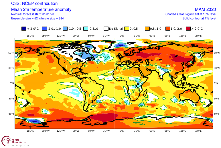
That low pressure drives the negative temperatures over east Canada while the rest of the continent is above normal. This is perhaps not such a good reflection of overall circulation, as the colder air could go further south into the NE USA. Eurasia is totally above normal even in this model, as we have a positive AO, with the North Pole being under lower than normal pressure, locking in the colder air.
Percipitation forecast from NCEP is more neutral, with hints of slightly drier conditions over parts of Europe as the higher pressure reigns supreme.
Meteo-France
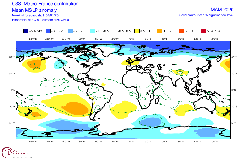
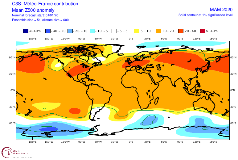
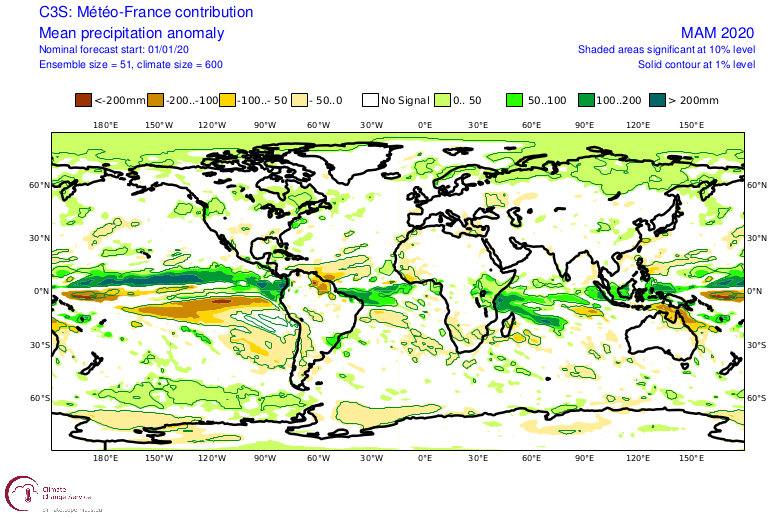
Meteo-France is not the long-range forecasting system that we would use conventionally, since it is not that easily accessible, and is a bit less famous than its UK and USA counterparts. And we can see that it has the most different forecast of the other 3 models. It does not have as a defined positive NAO as other models. It has similar areas of low-pressure indication over Canada as the NCEP, but it completely lacks a defined low-pressure area int the North Atlantic. It does have lower pressure over the North Pole, keeping the positive AO. The circulation still has high pressure over Eurasia, and the lower pressure over Canada and briefly in the northeast Pacific, also build strong ridging over the USA.
The temperature forecast, of course, reflects that, as strong above normal temperatures are shown over the United States under the ridge, while neutral temperatures are indicated for far east Canada. Eurasia as a whole is again under above-average temperatures.
The ridging and above normal temperatures over the United States are reflected in the precipitation anomalies, as we have drier conditions over the continental United States, but wetter conditions over parts of Canada associated with the lower pressure indicated by the model. Northern Europe is wetter, thanks to the lower pressure over the North Pole, but central and southern Europe is mainly neutral to drier in parts, due to higher pressure over the continent.
SUMMARY
Most forecasts are yet again showing certain lower pressure in the North Atlantic, and higher pressure over the North Pacific, Central Atlantic, and Europe, extending further east. There seems to be a general consensus about above-normal warmth in spring over Europe, with neutral to drier conditions, more likely in the southern parts. Every year, spring cold air intrusions are always likely into continental Europe, but such forecasts as we see above, do reduce the chance of prolonged cold air outbreaks, as the general circulation pattern is not supportive. During pattern re-adjustments, there are possible windows that colder air can move over the continent, but longer colder episodes of frost are not expected for now.
North America is a bit more complicated, as it is perhaps a bit more sensitive to the strength/positioning of the low-pressure area in the North/West Atlantic. The general consensus does seem to be that neutral to colder than average conditions are likely for parts of eastern Canada, while the weather in the central and eastern United States seems to be more dynamic, with a higher chance of colder spring air intrusions than in Europe, at least in the early spring.
As we move into February, the stratospheric polar vortex starts to lose its strength, and is much more susceptible to any attacks from below. A sudden polar vortex collapse could cause major changes to the overall circulation pattern, going into spring. There is currently no indication of a strong polar vortex collapse, but we will take a closer look at the possible development in our next update.
This is just an early look at spring, and we will refresh these outlooks as the models update with newer data in February, and we will have a better idea of what is to be expected in the upcoming spring. We will also take a first look at the pattern development for the upcoming 2020 tornado season across the Tornado Alley in the USA.
We will keep you updated on any important further development. In the meantime, don’t miss the latest activity in the stratosphere, where a double warming wave is starting to develop:
