Winter 2021/2022 is officially over. We will make a rundown of this very dynamic cold season, looking at the many cold and warm anomalies across the United States, Europe, and the rest of the globe. Also, we will look what was the main driver behind the weather this winter and how good the winter forecasts actually were.
To try and understand the Winter season and its forecast, we must realize that there is no “magic bullet” when it comes to weather. Global weather is a very complex system, with many large-scale and small-scale weather drivers.
But there was one major oceanic driver in this Winter season, that is actually still ongoing into Spring. We will look at its development, and how it will translate into Spring 2022 and also look at hints for its influence on the next Winter season 2022/2023.
COLD LA NINA IN THE OCEAN
A major driver of the winter season was the ENSO. That is short for “El Niño Southern Oscillation”. It is a region of the tropical Pacific ocean, changing between warm and cold phases in the equatorial ocean. Typically there is a phase change in around 1-3 years.
Below we have an image that shows all the ENSO regions in the. The main regions are 3 and 4 and cover a large part of the tropical Pacific. The main analysis and forecasts are focused on the main region, marked as Nino 3.4.

ENSO has a major influence on the tropical rainfall patterns (storms) and the complex exchange between the ocean and the atmosphere. Large-scale pressure changes are observed in the tropics with each new developing phase.
The image below from NOAA Climate shows the typical circulation during a negative ENSO ocean event. Air is descending in the eastern Pacific, creating stable and dry weather conditions. In contrast, air rises in the western Pacific, causing frequent thunderstorms and a lot of rainfall in the western Pacific.

This way, ENSO has a major impact on the tropical convection patterns and consequently on the ocean-atmosphere system. Through this delicate ocean-atmosphere system, it distributes its influence globally.
A specific phase (warm/cold) usually develops around late summer and early autumn and can last until next summer, or even up to two years in some cases.
The cold ENSO phase is called La Nina and the warm phase is called El Nino. Besides the temperatures, one of the main differences between the phases is also in the pressure state.
On the image below you can see the ocean surface temperature and pressure pattern difference between the warm and the cold phase.
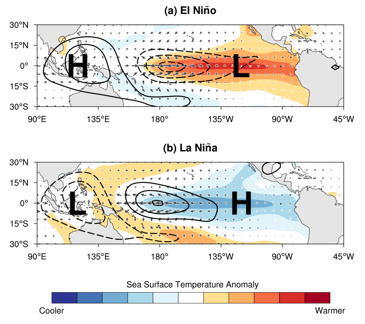
During an El Nino, the pressure over the tropical Pacific is lower, with more rainfall and storms.
But during a La Nina, the pressure over the equatorial Pacific is high, creating stable conditions and less precipitation. This obviously translates into the global circulation, affecting both the Northern and the Southern hemispheres.
Focusing on the ENSO 3.4 region, you can see on the image below how the ocean temperatures dropped in Fall 2021 which was the start of the La Nina. It has reached its max cold during Winter and is now slowly decaying into Spring.

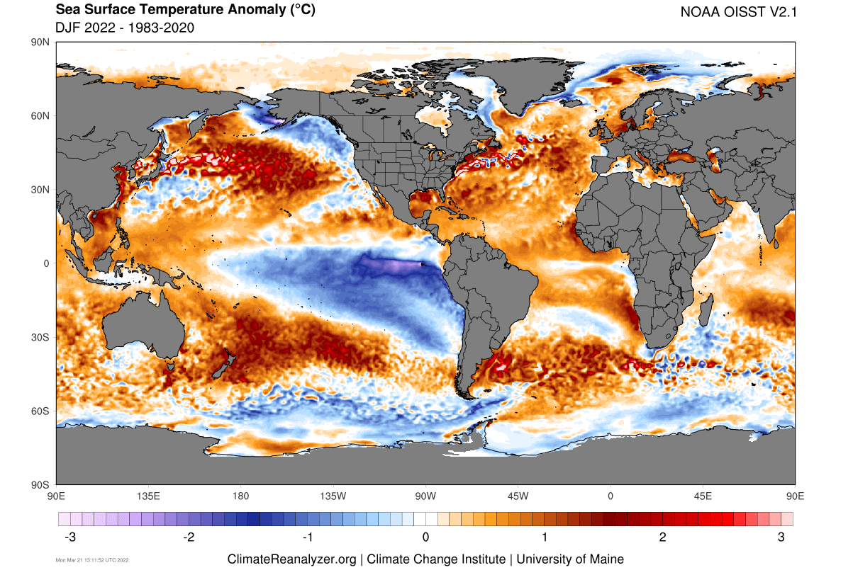
Below we have the global ocean temperature anomaly for the Winter season 2021/2022. We can see the strong cold anomalies in the tropical Pacific Ocean, associated with the cold La Nina phase.
Combining the strongest 13 cold ENSO events can give us an idea of what their main weather influence is. As you can see, the main feature of a La Nina winter is a high-pressure system in the North Pacific and low pressure over Canada.
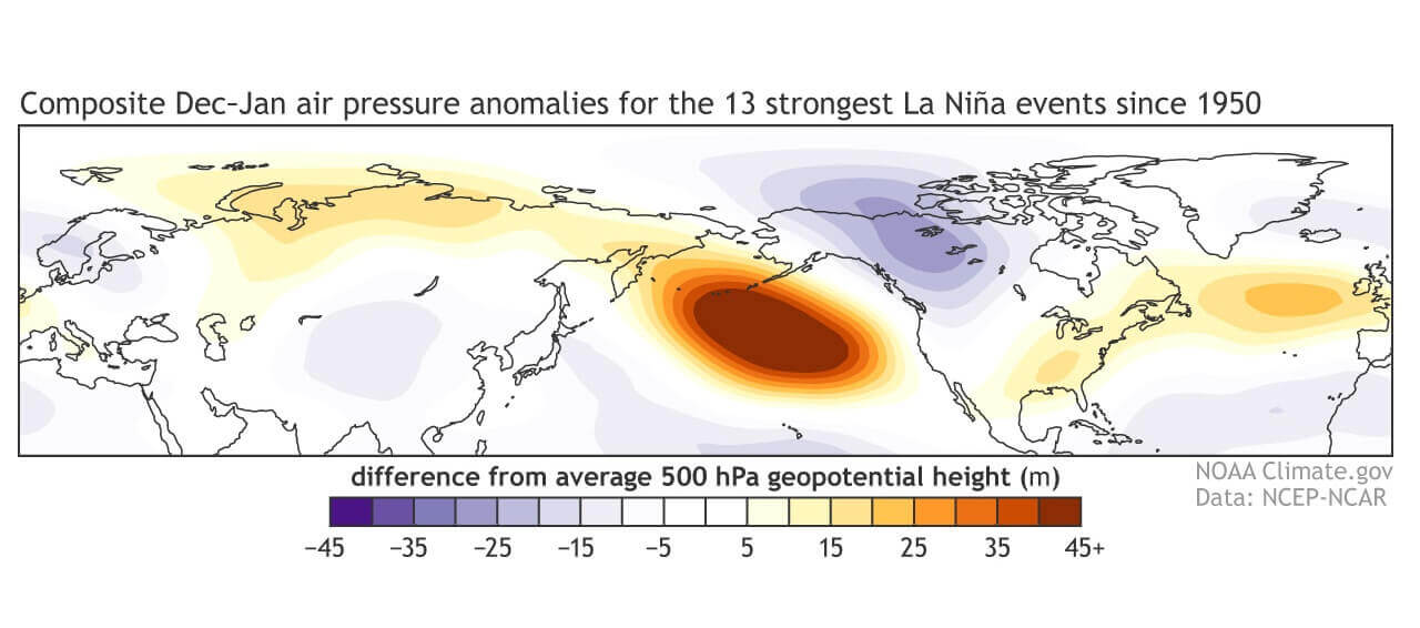
The circulation of the strong high-pressure system promotes the development of a low-pressure region over Alaska and Canada. It curves the jet stream downwards in-between the two pressure systems.
Over Europe, we do not have a clear signal, as the jet stream that exits North America, then has to deal with the pressure systems in the North Atlantic. Here, the influence from the overall Polar Vortex circulation comes more into play.
You can see the North American winter pattern in the image below. It shows the average position of the jet stream during La Nina winters and the corresponding weather patterns that it produces.

The curved jet stream brings colder air and storms down from western Canada into northern and the northwestern United States, and warmer and drier weather to the southern parts of the country.
This can heavily change the jet stream pattern exiting out into the North Atlantic, impacting the winter weather in Europe.
Knowing what was behind the winter weather patterns, we can now look at the seasonal analysis of the Winter 2021/2022. After this, we are going to take a look at how will these same weather drivers transition their influence into the weather patterns of Spring and early Summer.
WINTER 2021/2022 RUNDOWN
Meteorological winter covers the coldest 3 months of the year: December, January, and February. Summer covers the 3 warmest months of the year: June, July, and August.
Spring and Fall are the transitional seasons between the warmest and the coldest part of the year. This means that meteorological seasons perfectly cover the whole year, actually based on the coldest and warmest parts of the year.
This is slightly different from the astronomical winter. So when looking back at a weather season, we always use the official meteorological periods, as those are the official statistics.
We will first make a monthly breakdown of the Winter season. Then we will look at the whole seasonal average before diving into the forecast part of the article, looking at Spring and early Summer 2022.
DECEMBER 2021 WINTER WEATHER ANALYSIS
December is the first month of the meteorological winter season. It began under the strong influence of the La Nina. We can see that on the pressure pattern image below, revealing a very strong high-pressure system in the North Pacific.

We now know that this is a classical weather response to the La Nina. This blocking high meant a pressure drop over western Canada and a pressure rise over the southeastern United States. A ridge was building over western Europe, bringing down colder air into northeastern Europe.
Looking closer at Europe first, we can see that cold air over northeastern Europe. The rest of the continent was pretty much under warmer than normal temperatures.

A much more dynamic pattern was unfolding in North America. We can see a strong contrast of unusually cold temperatures over western Canada and unusually high temperatures over the southern United States.
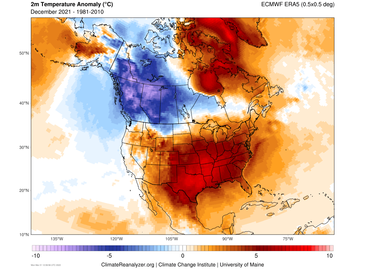
This is the expected temperature response to a La Nina, which came in strong in December. Cold records were broken in western Canada and record highs were recorded in the southern United States.
Precipitation-wise, we will be looking mostly at the snow, as that is the form of precipitation typically “most wanted” during the winter season.
The image below shows the snow depth anomaly for the month of December. Looking first at Europe, we see a quite low snow cover across the continent. Above-average snowfall was recorded in northeastern Europe with the cold air. Over central Europe, we mostly saw snow cover in the higher elevations.

Snow depth anomaly in North America comes as expected from the temperature picture. Pretty much most of the south and the eastern United States had an absent snow cover. Above-average snow depth was recorded in northern California and Nevada, and of course in parts of western and southeastern Canada.

JANUARY 2022 WINTER WEATHER ANALYSIS
Going into January, the pattern changed slightly. The La Nina high-pressure system in the North Pacific is still there, but it moved further towards the northwest. And a separate high-pressure system formed over the west coast of the United States.

That west coast high has paired with the low-pressure system over eastern Canada. It has brought the jet stream down into the eastern United States. That also helped to sustain a stronger high-pressure system out in the North Atlantic, extending into western Europe.
Looking at temperatures in Europe, we can see a different picture than in December. We can see colder air intrusions into western Europe under a northerly flow. Mostly warmer than normal temperatures prevailed over the rest of the continent.

A huge temperature reversal was seen over North America. The cold pool has shifted into eastern Canada, with the jet stream extending down into the eastern United States. That has helped to sustain a colder northerly flow into the Midwest and the northeastern United States.
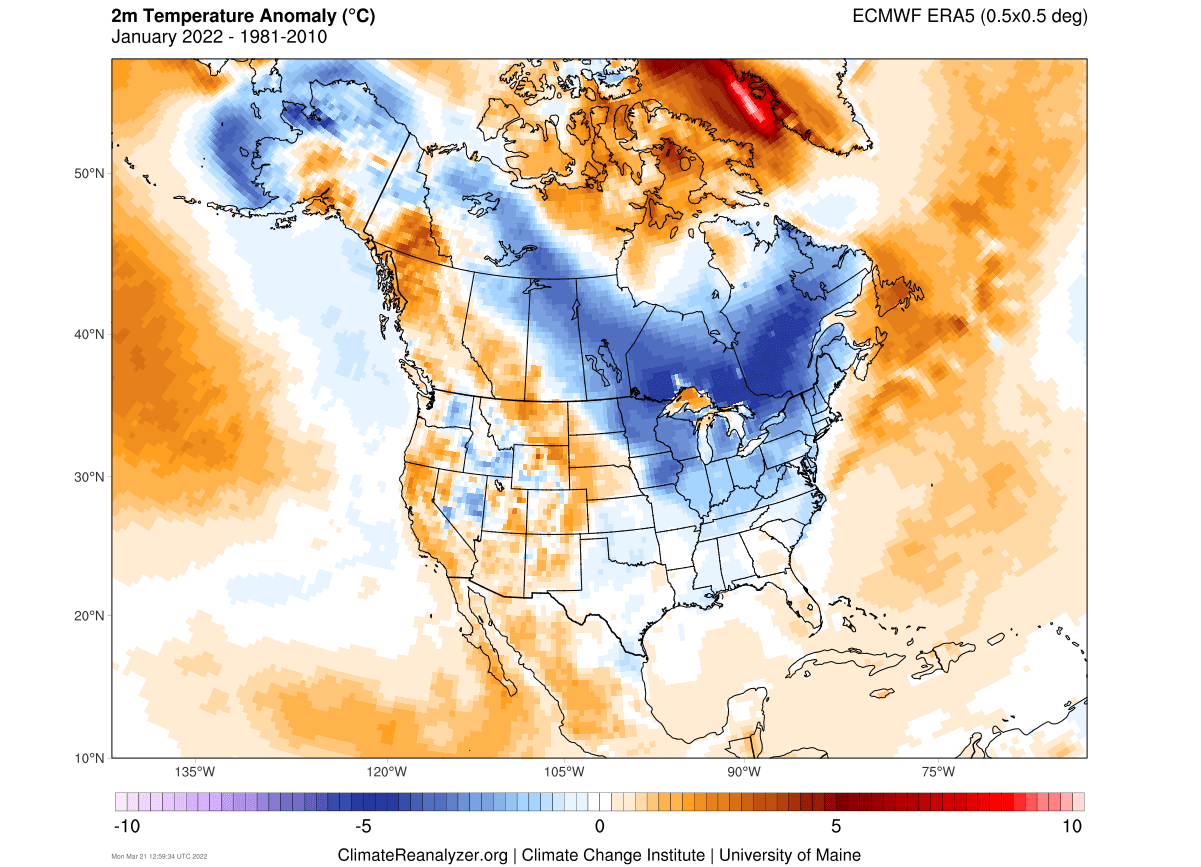
Most of the western United States and far western Canada were in warmer than normal temperatures, under the high-pressure system.
Looking at snow depth in January, we can see a similar picture to December. Northeastern Europe still got more snowfall than usual. Over the rest of Europe, there was mostly less snowfall than normal, due to limited moisture (dry airmass).
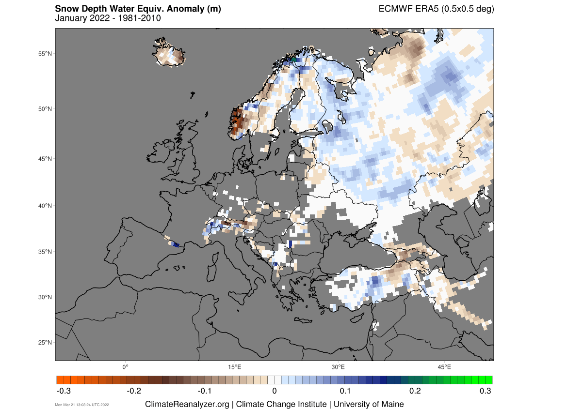
In North America, we can see the snow cover now extending in the Midwest and in the northeastern United States, thanks to the colder air source. Note the much above normal snowfall continuing in parts of western United States.

FEBRUARY 2022 WINTER WEATHER ANALYSIS
February’s pressure pattern saw another adjustment. We can see that the high-pressure system has amplified over the west coast of the United States and Canada. That bring the jet stream again down into the United States, but slightly further west this time.
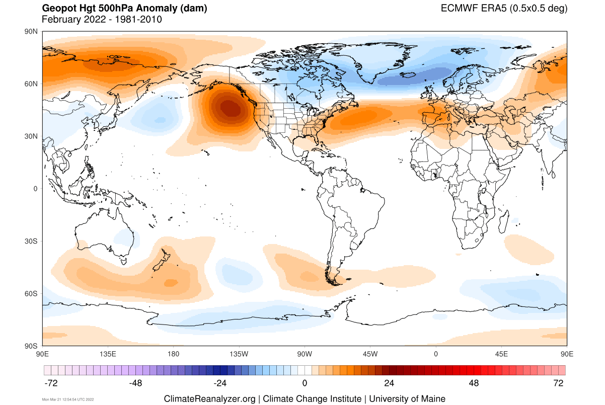
In the North Atlantic, we witnessed a strong positive NAO pattern. That means a strong westerly flow pattern into most of Europe.
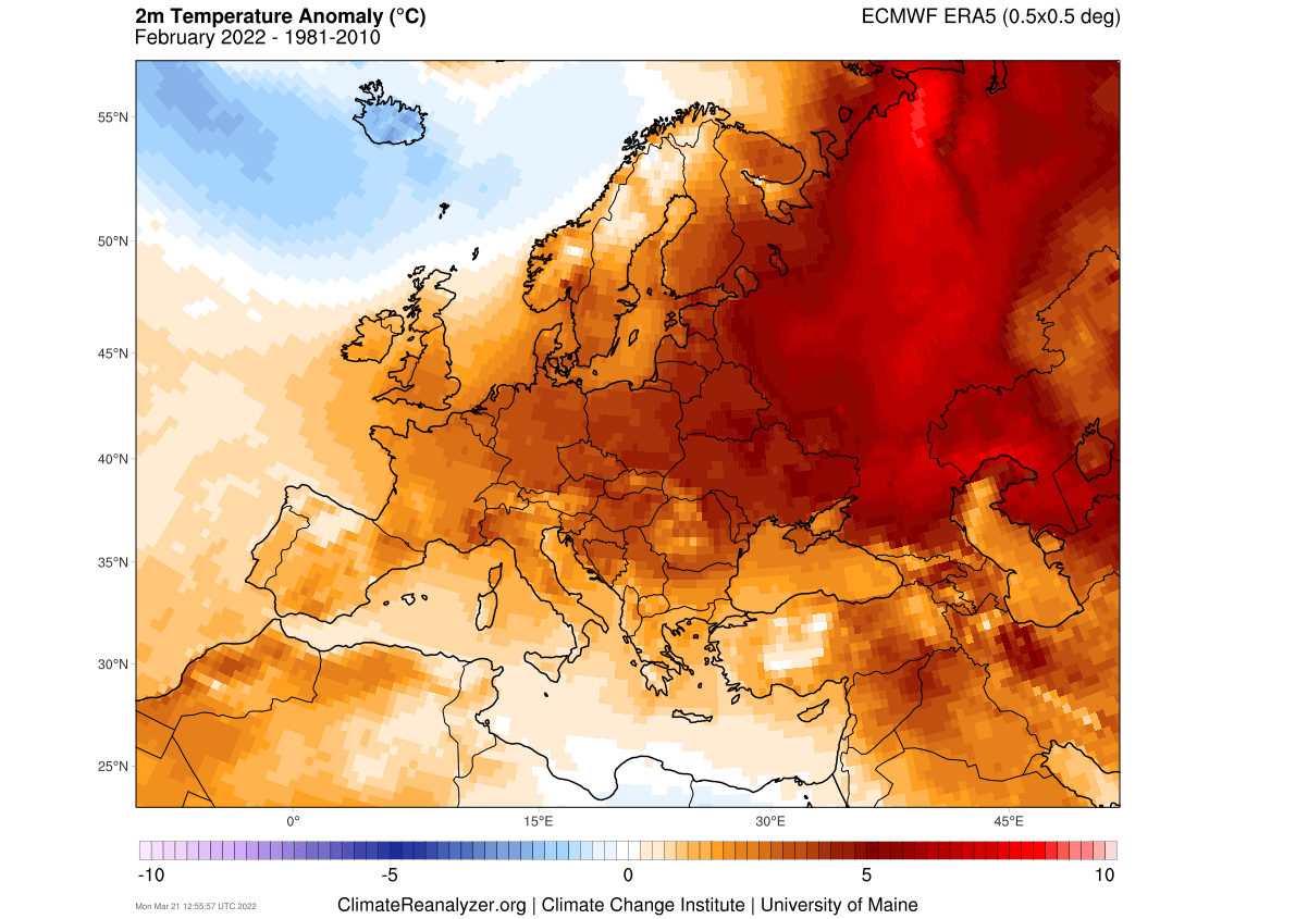
We can see that on the temperature anomaly analysis. February was serving some intense anomalies over the continent, especially in the eastern regions. Colder air intrusions were fewer, keeping the monthly average high above normal.
Over North America, we can see a pretty cold month overall. The strongest cold anomalies have moved further back west, covering central Canada, and extending down into the northern United States.
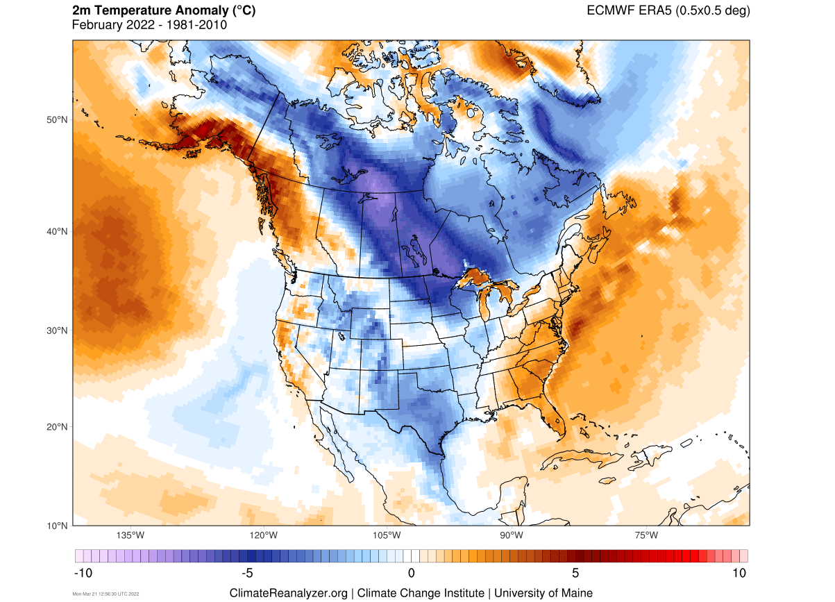
Most of the United States finished the monthly average colder than normal. The exceptions are the states of California and Oregon and the southeastern United States under the ridge.
Despite strong warm anomalies, we were still recording more snowfall in northeastern Europe. Most of central Europe had below-average snowfall.

We can see below that the snow cover was stable over the Midwest and the northeastern United States. Keep in mind that this is a monthly average, and some events dropping snow for just a few days can get lost in the average.
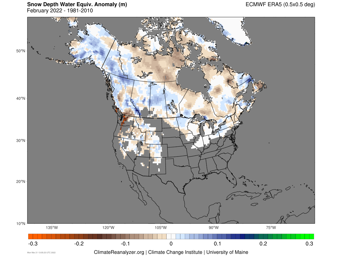
There was still more snowfall than normally recorded in western Canada and parts of northern and northeastern United States. Quite less snowfall was recorded in the northwestern United States.
We will now combine all the winter months and look at the seasonal average, comparing it to the forecast before the winter began.
WINTER 2021/22 FINAL WEATHER ANALYSIS AND FORECAST
We will be looking back at the forecast from November, which is the last Autumn month. The forecast from the ECMWF model is used, as it is usually deemed as the most “reliable” long-range model. Of course, it can have its good and bad seasons.
The forecast (and analysis) is centered on the December-January-February seasonal period, designated as DJF on the graphics.
Below we have the ECMWF forecast for the global pressure anomalies. Right away we can see the strong high-pressure in the North Pacific from the La Nina. A natural response is a low-pressure over Canada and the jet stream riding in-between.
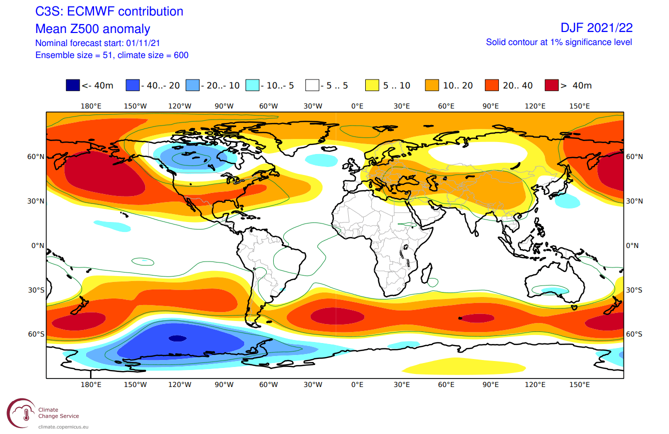
It had a low-pressure area over the North Atlantic and high-pressure over most of Europe, with the exception of the west.
In reality, the model did quite a good job over North America. We can see the high pressure in the North Pacific and the low-pressure area over Canada. This was an easier task for the model, having the La Nina background forcing.

It had a worse idea over Europe, with an almost reversed pressure anomaly pattern. High-pressure was dominant over the west and low in the east.
For global temperatures, we tend to use the 850mb level. This is at around 1.500m (5.000ft) and is a good representation of the airmass.
On the forecast below, the ECMWF was forecasting a strong cold pool over Canada, bordering down into the northern United States. The Southern United States was forecast to be mostly under warmer than normal airmass, and also over Europe.

Yet again, the forecast was very good for North America. We can see the strong cold pool over Canada, extending into the northern United States, and warmer anomaly in the southern half of the country.

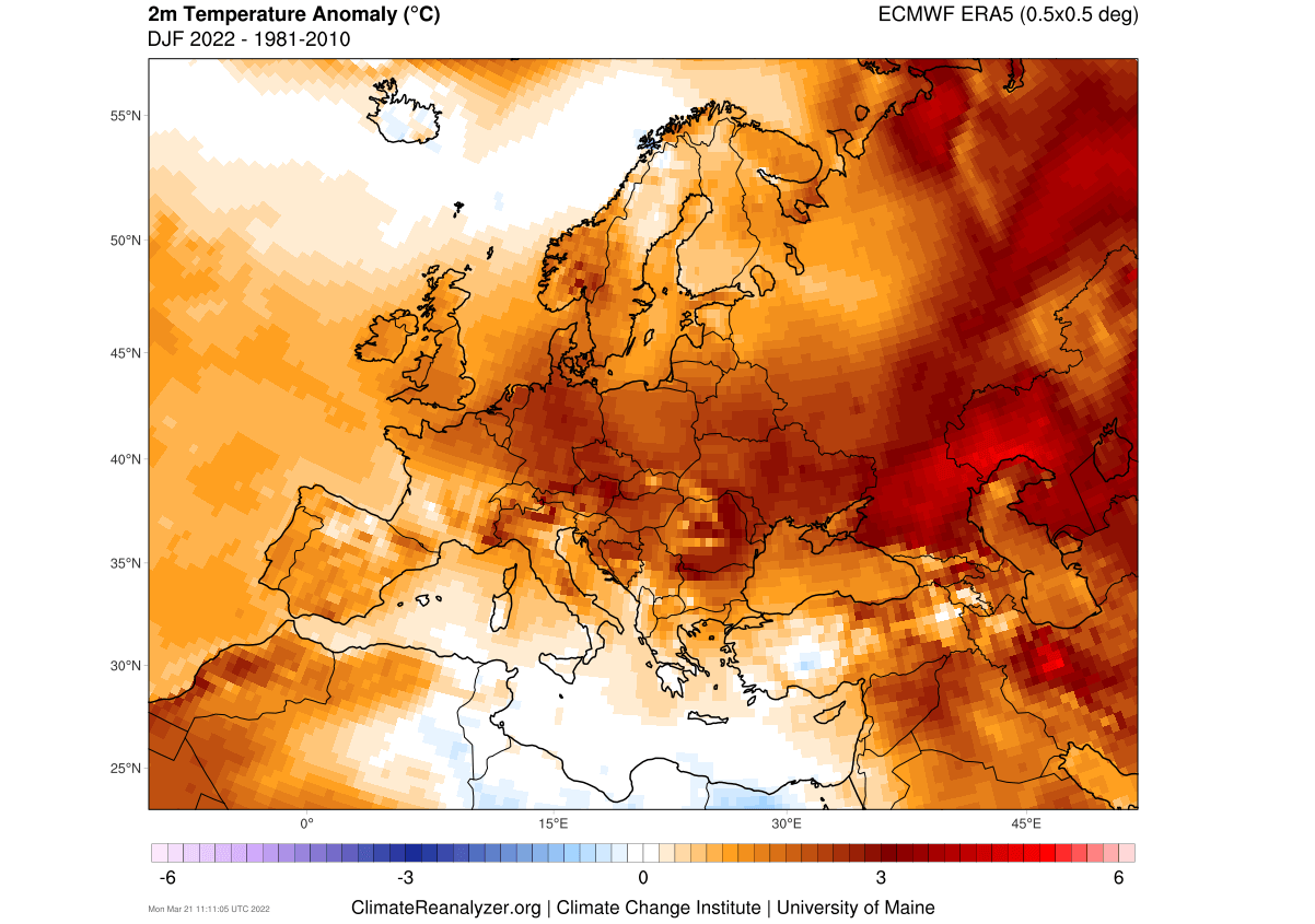
Europe had mostly warmer than normal airmass over western and central parts and neutral to colder in the eastern regions and Scandinavia.
But actual surface temperatures that we feel can differ from the raw airmass anomalies. Below we have the full seasonal average picture for winter. Pretty much the whole of Europe ended warmer than normal.
A different story was with surface temperatures over North America. Here the strong cold anomaly really stands out over Canada, extending into the northern United States. The rest of the United States was mostly warmer than normal. But this is largely due to the unusually strong warm anomalies in December.

Looking at total winter season snow depth, there was more snowfall over the northeastern regions, and quite less over mainland Europe.

A decent snow cover extent was recorded over the whole season in the United States. More snowfall than normal was actually recorded over some parts of the northern United States and the higher elevations of California and Nevada.

Finishing with the global precipitation forecast, we can see a mostly neutral state over Europe, with more precipitation in the northeast. Over North America, the ECMWF winter forecast called for more precipitation over Canada and the northern United States.

Less precipitation was forecast for the southern United States. This is again a more typical La Nina precipitation distribution over North America.
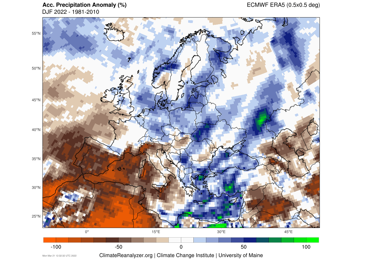
Looking at the actual precipitation anomalies, we can see more precipitation over north-central and northeastern Europe. Drier conditions prevailed over western and southwestern Europe.
The ECMWF winter forecast was more accurate for North America. More precipitation over Canada, part of northern United States, and over the Ohio Valley. Mostly drier than normal conditions prevailed over southern and south-central United States.

All in all, the ECMWF model forecast actually performed quite well over North America, thanks to the active La Nina ENSO phase. It provided a source of forcing for the model to grab onto.
It performed poorly over Europe, as the La Nina influence is also greatly diminished there. The signal/influence of the La Nina gets mostly attenuated via the North Atlantic.
NOAA OFFICIAL WINTER FORECAST
NOAA also releases its seasonal forecasts for the United States. They also release a verification once the season is over. Below we have their temperature and precipitation forecast for the United States and the resulting verification.
Looking at temperatures first, we have the forecast on the left. They were calling for a La Nina pattern, with warmer in the south/east and colder in the northwestern United States.

The actual anomalies were mostly warmer over the south-central states and over the eastern United States. Colder temperatures were recorded in the northern United States and parts of the southwest. Overall, it was a good forecast.
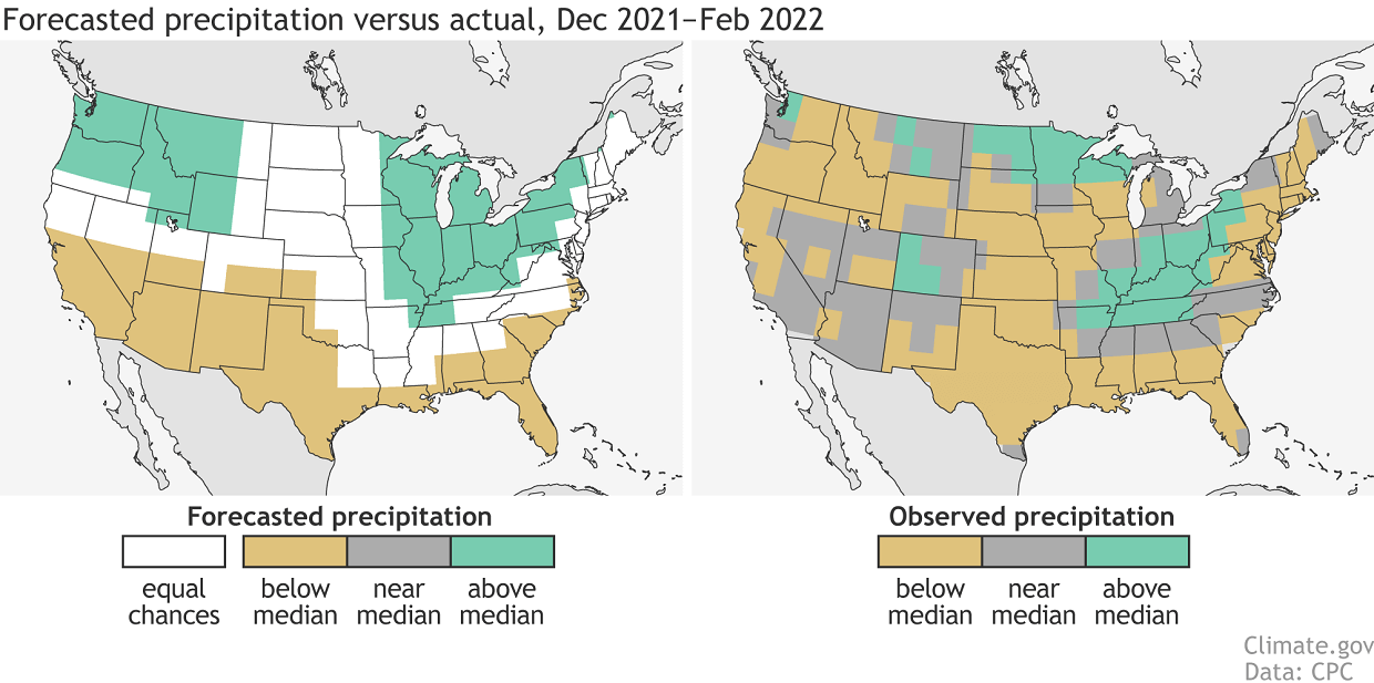
A similar picture is seen with precipitation. More precipitation was called for the northwestern United States and parts of the Midwest and the northeast. The eastern half had better success, while most of the western United States was drier than normal.
Now, the Spring is already underway. We will look at how the weather drivers are transitioning from winter into spring, and what the latest forecast shows for the weather development into early summer 2022.
FROM WINTER TO SPRING
As we know, the cold oceanic La Nina was a strong driver behind the winter weather patterns in the 2021/2022 season.
Below we have the latest ocean temperature anomaly analysis, which shows that La Nina is still present in the tropical Pacific Ocean. Notice the cold anomalies still present in that region. They are much weaker than in winter, but the atmospheric influence can persist for a longer period.

The latest forecast from ECMWF shows the La Nina weakening and disappearing into early summer 2022. Neutral ENSO conditions are expected during the summer.

We can tell from the current status and forecast of the La Nina, that its influence will be felt over most of the Spring season. But there is one more “shorter-term” influence that can’t be denied in the current stages of the Spring season.
That is the Polar Vortex, which is basically the polar circulation over the Northern Hemisphere. Before going into the Spring/early Summer forecast, we will look at what importance the Polar Vortex will play along with the La Nina.
THE COLD SEASON POLAR VORTEX
Every year as we head into autumn, the polar regions start to receive less sunlight. This way, cooling begins over the north pole.
But as the polar temperatures drop, the atmosphere further south is still relatively warm as it continues to receive light and energy from the Sun.
You can see the winter solstice in the image below. The polar regions receive little to zero solar energy, compared to regions further south, which still continue to receive plenty of sunlight and energy.
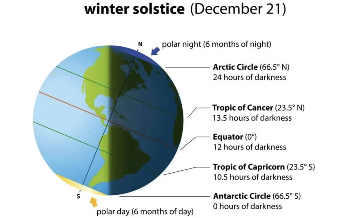
But, the temperature is dropping over the polar regions, and of course, the pressure follows. With colder temperatures over the pole, the temperature difference towards the south increases.
This causes a strong global pressure difference, and a large low-pressure (cyclonic) circulation starts to develop across the Northern Hemisphere. It extends from the surface layers, far up into the stratosphere. This is known as the Polar Vortex.
The image below shows a typical example of the peak strength Polar Vortex at around 30km/18.5miles altitude (10mb level) around the middle stratosphere during the winter season.
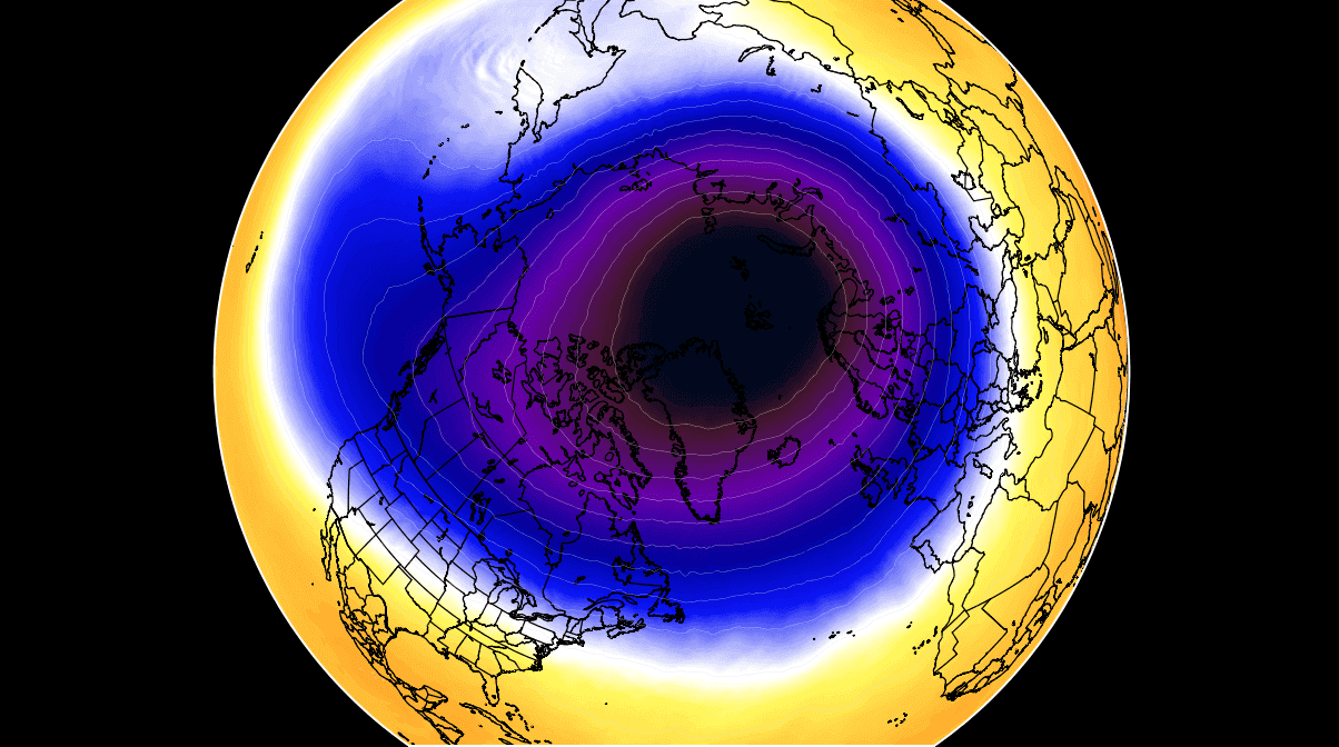
It is behaving like a very large cyclone, covering the whole north pole, down to the mid-latitudes. It has a strong presence at all levels, from the ground up, but can have different shapes at different altitudes.
It is basically one large cyclonic area that is spinning over the entire Northern Hemisphere, from the ground up to the top of the stratosphere and beyond, reaching over 50km/31miles in altitude.
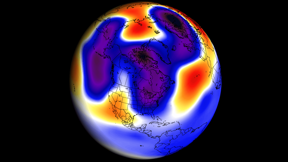
The image below shows the seasonal geopotential height anomaly in the stratosphere for the winter season. We can see that the polar vortex was running with lower pressure, meaning it was stronger than normal, also enabling stronger polar circulation.

We can see that below on the zonal wind speed graph for the Polar Vortex at 10mb level. The black line is the long-term average, and the blue line is the polar vortex strength in the 2021/22 cold season. We can see that for most of the cold season, the polar vortex was stronger than normal.

But as you can see on the graph above, the polar vortex came to a quick end in March. The polar vortex circulation collapsed in mid-March, creating a disturbance in the circulation for the days/weeks to come.
We produced a video that shows the 10mb level (30km/18.5miles) development of the polar vortex collapse. We can see the Polar Vortex first being split apart, followed by a strong displacement and weakening.
On the image below we can see the pressure anomalies in the atmosphere, changing with time. The blue color corresponds to lower pressure (stronger polar vortex). But notice the high-pressure coming down from the stratosphere in the next days/weeks.

This is the result of the abrupt collapse of the Polar Vortex, which will play its role in the more medium-term weather development as we go deeper into Spring.
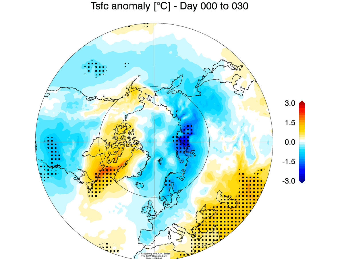
Below is an image that shows an average temperature pattern 0-30 days after a collapse of the Polar Vortex. High pressure over the Arctic from the collapse can help to unlock the cold air out of the Arctic regions, sending it down into the mid-latitudes of the United States and Europe.
Looking at the extended range ensemble forecast for mid-April, we can see a region of higher pressure over the Arctic regions. The main low-pressure zones are over Siberia and eastern Canada/Greenland.

Based on the available forecast data, this is a likely aftermath scenario from the collapse of the Polar Vortex, as we have seen above.
On the temperature forecast for the same period, we can see the trend for colder air to remain over Canada and the northern United States. Warmer than normal temperatures remain over the Arctic regions under high pressure.

This is a very similar pattern to the expected aftermath of the Polar Vortex collapse that we showed above.
Knowing what is going on in the ocean and in the atmosphere, we will finish with the long-range forecast for the rest of the Spring season and early Summer 2022.
SPRING TO EARLY SUMMER LONG-RANGE OUTLOOK
We will be using the ECMWF long-range model (SEAS-5), as it is often referred to as “the best” model for long-range forecasting. And as we have seen above, has had a decent skill for the Winter forecast.
The forecast period we will be focusing on is April-May-June (AMJ 2022). This period covers two remaining months of meteorological spring and the first month of meteorological summer.
In the pressure pattern forecast from ECMWF below, we can see a strong La Nina high-pressure system continuing in the North Pacific. A low-pressure system is still indicated over western Canada. Another broader low-pressure area is over the eastern Polar regions.

The global temperature distribution is partially similar to the past winter patterns. Over North America, we see indications of colder temperatures over western Canada and Alaska, transitioning down into the northwestern United States. The southern United States is forecast to be quite warmer than normal.
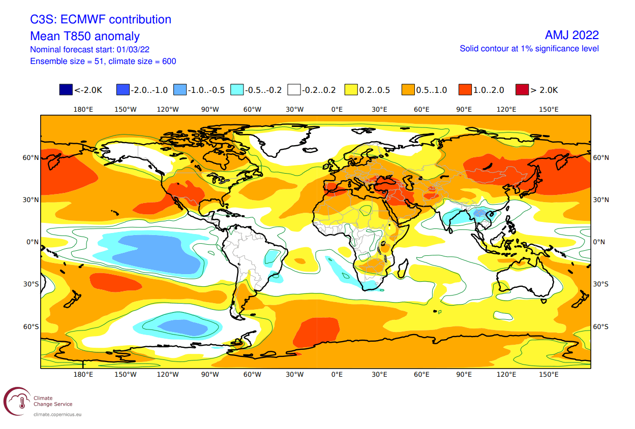
Europe features mostly warmer than normal conditions, with a storm track further to the north from the North Atlantic into northern Scandinavia.
Looking closer at Europe, we see warm anomalies over most of the continent. The pattern that ECMWF suggests still leaves the door open for cooler northerly flow from the northwest into parts of central Europe.

Over North America, we see the neutral area extending down from Canada further into the northwestern United States. This is the most likely area to see colder than normal temperatures. But we also see a weaker warm anomaly area in the Midwest and the northeastern United States.

Warm anomalies are a certainty for the southwestern United States. The pressure pattern that the ECMWF shows for the southern United States are also in agreement with other seasonal forecasts, increasing the confidence of the forecast.
The precipitation forecast shows the drier conditions over most of the western United States. But parts of the eastern United States have a higher chance of wetter conditions. Europe features higher precipitation over northern regions, due to the higher frequency of low-pressure systems moving over this area.

Such precipitation distribution is of concern, as it is maintaining severe drought conditions over the south and especially the southwestern United States. The drought conditions are already present strongly over the west and south, as seen on the analysis below by the United States national drought monitor service.

Looking at the NOAA official temperature outlook, colder to normal forecast prevails in the northwestern United States. The southern and eastern United States have a higher probability of warmer than normal weather, as seen in the model forecast above.

The official precipitation forecast is also quite similar to the model forecast. We see an equal-to-higher probability for more precipitation in the Midwest and the Ohio Valley. Most of the western United States, however, is forecast to have a drier than normal season towards summer.

WINTER SEASON 2022/2023 EARLY HINTS
It is impossible to forecast a weather season this far out. But what we can do, is look at the large-scale direction of the development.
Focusing on the strongest weather driver last winter, the ENSO, we can look at the expected trends for later in the year.
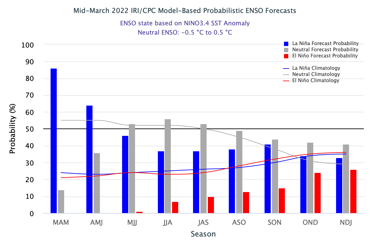
Below is the CPC/IRI official probabilistic ENSO forecast. It shows the current La Nina lasting into the early summer. Later in the year, it shows mostly neutral probability, with neither La Nina nor an El Nino developing for the winter season.
The image below is a consolidated analysis and forecast image from multiple North American seasonal models. It also shows the La Nina reaching the late spring season. But going ahead into 2022, we see a return to the neutral phase (between 0.5 and -0.5), with a slight chance of an El Nino developing later in 2022.

The most recent ECMWF extended seasonal forecast also shows the cold phase ending in Spring. Going ahead, there is a high forecast spread, with the average staying in the neutral zone for next winter season. Historically, besides the neutral phase, an El Nino would be more likely than a new La Nina.

But how is an El Nino important? Well, if the ENSO would stay neutral, then other global drivers would take over, making for a very unpredictable winter season. But if even a weak El Nino would develop, it would serve as guidance for the weather development.
In the El Nino winter season, we have a strong and persistent low-pressure area in the North Pacific. That pushes the polar jet stream further to the north, bringing warmer than normal flow to the northern United States and western Canada. The southerly Pacific jet stream is amplified, bringing storms with lots of precipitation and cooler weather to the southern United States.

Looking at the average snowfall for an El Nino winter, we can see a much different picture than with the La Nina. There is less snowfall in the northern United States during the El Nino seasons. Mostly warmer than normal and drier than normal conditions in the north limit snowfall.
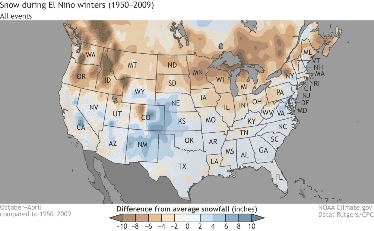
But there is more snowfall in the west-central United States and in the parts of the eastern United States, with cooler weather and more moisture available.
We will release regular weekly and monthly updates on weather development, so make sure to bookmark our page, and also, if you have seen this article in the Google App (Discover) feed, click the like button (♥) there to see more of our forecasts and latest articles on weather and nature in general.
SEE ALSO: