Hey, don’t pack the winter clothes yet, although we are already at the end of the first month of the meteorological spring season. Yet another and actually a pretty intense Arctic cold air intrusion will spread from Canada into the Northeast United States this weekend into early next week. Although the very active Polar Vortex during the recent cold season has finally broken down, its collapse will lead to some pretty dynamic weather patterns in the coming weeks.
While the Polar Vortex has significantly weakened with the arrival of the spring season recently, the cold weather is not giving up just yet. When the vortex is strong during the winter months, the frigid cold air is spread over the Arctic region, having occasional intrusions towards the southern latitudes. Once it weakens and its core warms, there are some of its final effects of cold air pools spreading down towards the ground.
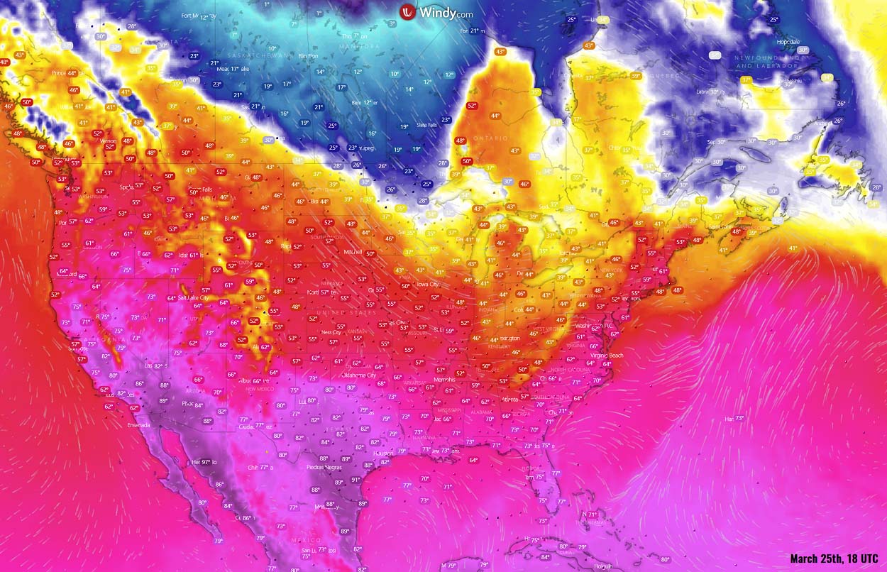
One of these waves is emerging over North America this weekend, spreading into eastern Canada and Northeast U.S., thanks to favorable weather patterns developing over the continent. Bringing a strongly anomalous air mass over the region, with a refreshing few days of nearly 20 °F below normal temperatures.

The highest daily temperatures for New York and Boston could stay just above freezing on Monday next week, low 40s in Washington D.C. as well. Compared to what was experienced these days, it will be *much* colder. With the real feel even lower, as breezy northwesterly will be present as well.
On Friday afternoon, the cold air was already advancing south-southeast across southern Canada prairies into the Upper Midwest, while the upper 50s to low 60s were observed across the Mid-Atlantic, Northeast, and New England. The change through Sunday will therefore be quite intense there.
Although the days will be rather just cold and dry, some spring snow will return the cold season memories for places across the Northeast U.S. and eastern Ontario. Strong and cold northwesterly winds will introduce lake-effect snowfall, dumping around a foot of snow along the southeastern shores of Ontario and Erie lakes through the next several days.
One interesting thing to note with the upcoming event is that exactly 10 years ago, in March 2012, one of the greatest heat waves was observed in many regions of the North American continent. Extremely warm air spread northward west of the Great Lakes region and subsequently spread eastward and into Canada. The warm surge brought a remarkably prolonged period of record-setting temperatures for many states.
NOAA’s Climate Data Center has reported that over 7,000 daily record high temperatures were tied or broken through March 2012, with some places having temperatures exceeding 86 °F (30 °C). For instance, in Grand Rapids (Michigan), had the highest temperature recorded on March 21st, it was 87 °F (or 31 °C), Chicago also banked a high of 87 °F on that same day. Numerous records were broken in unusual ways.
These days will bring far from this. A major intrusion of Arctic air will bring us back to winter mode. But before we dig deeper into the weather pattern developing for the upcoming new cold Arctic blast, let’s quickly go through what the Polar Vortex really is.
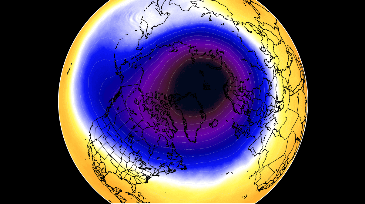
To give you an idea and view of the Polar Vortex dynamics, we produced a high-resolution video, which shows how the fast collapse event occurred. The video reveals the 10 mbar level (approx. 18.5 miles or 30 km) model chart. We can see how the Polar Vortex first is split apart, followed by a strong displacement and weakening.
These dynamics of the Polar Vortex are crucial to understanding the background processes it does to our weather.
WHAT IS THE POLAR VORTEX
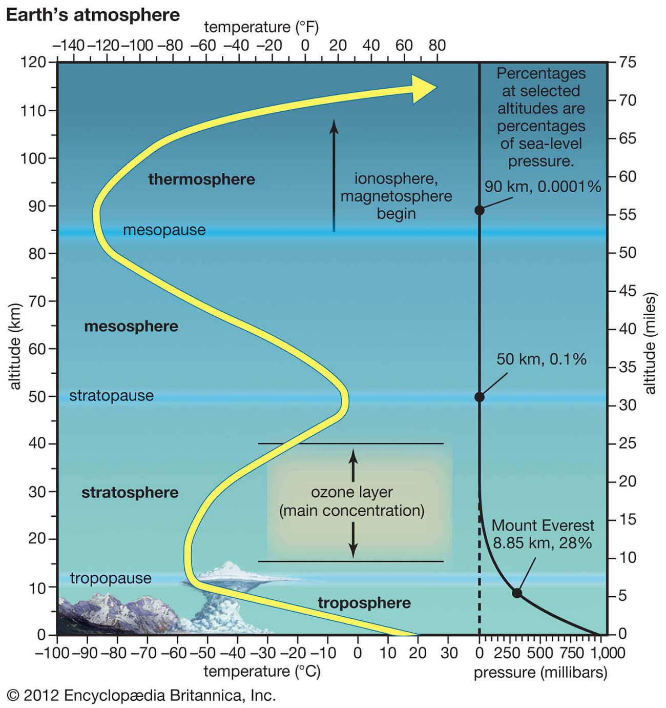
Let’s first see how the Earth’s atmosphere is built, so we can understand its other features further. There are six layers that are rounding our planet with the majority of the dynamics for our daily weather occurring in the lowest two layers. Those two layers are the troposphere and the stratosphere.
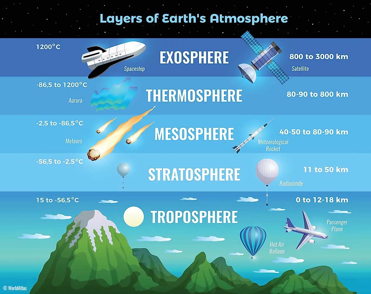
The closest layer to the Earth’s surface is the troposphere, about 12 km deep from the ground into the sky. The depth of it varies from around 8 km to almost 20 km, depending on where on Earth you live. The troposphere layer is the deepest above the equatorial region, but it gets much thinner above the North Pole (and the South Pole).
Above it, there is a much deeper layer, known as the stratosphere. The stratosphere is an 11-50 km thick layer and the air in it is also very dry. We also find the Ozone layer there, the one that has a vital role in the protection of our planet’s life against the potential storm impacts from the Sun or outer space.
Another thing in the stratosphere, which is making our weather even more variable and dynamic, often triggers some significant large-scale weather events. This is the Polar Vortex. An enormous, tri-dimensional ring of very powerful winds moving through the sky high above. The Polar Vortex is spinning around the North Pole during the cold season very fast, grazing through the air at about 20-50 km above the Earth’s surface.
Both the troposphere and the stratosphere are very crucial for the climate, as the Polar Vortex covers most of the bottom half of our atmosphere. It extends from the middle of Earth’s troposphere up into the stratosphere layer. And as it is the strongest during winter, it has a significant impact on the weather across the high and mid-latitudes every year.

We could see these strong effects quite a lot across Canada, the U.S., and partly also in Europe and Asia this past cold season, as the Polar Vortex was so intense.
So, although it spins well above our heads, it remains close-connected with the lowest parts of the atmosphere we live in. Thus, our daily weather shape is led by the Polar Vortex in many different ways, as this feature works as one large hemispheric circulation in general.
Most of the dynamic and intense weather systems and winter storms, from the frigid cold outbreaks in Canada and the United State over the recent months, have been triggered by the activity of the Polar Vortex above us.
How and when the Polar Vortex forms?
After September, the polar regions begin to receive much less energy from the Sun over time. This way, the northern regions are cooling stronger and as a result, polar nights also occur. So, for several consecutive months, days without any sunlight follow.

The polar region temperatures are dropping into hard freeze, while the atmosphere layers farther to the south are still relatively warm as they continue to receive more Sun’s energy also through the cold season. The equatorial layers to the south do remain much warmer compared to the areas farther to the north. This result is a high-temperature contrast between them.
The strong cooling of the polar regions also leads to lowering the surface pressure, and a pretty similar weather process is also happening in the stratosphere layer. So the temperature difference between the North pole and the equatorial areas increases a lot across both layers. Creating a large low-pressure cyclonic circulation across the polar stratosphere. There is a hint of how this feature got its famous name, huh – the Polar Vortex.
We can now put all these puzzle pieces together and understand, that the Polar Vortex is actually acting as a very large cyclone in the lowest parts of our huge atmosphere. It basically expands across the whole North Pole during winter months and becomes very intense at times, extending far south to the mid-latitude regions. Note, that a pretty similar process is also happening in the southern hemisphere during their cold season when the Polar Vortex intensifies around the South Pole.
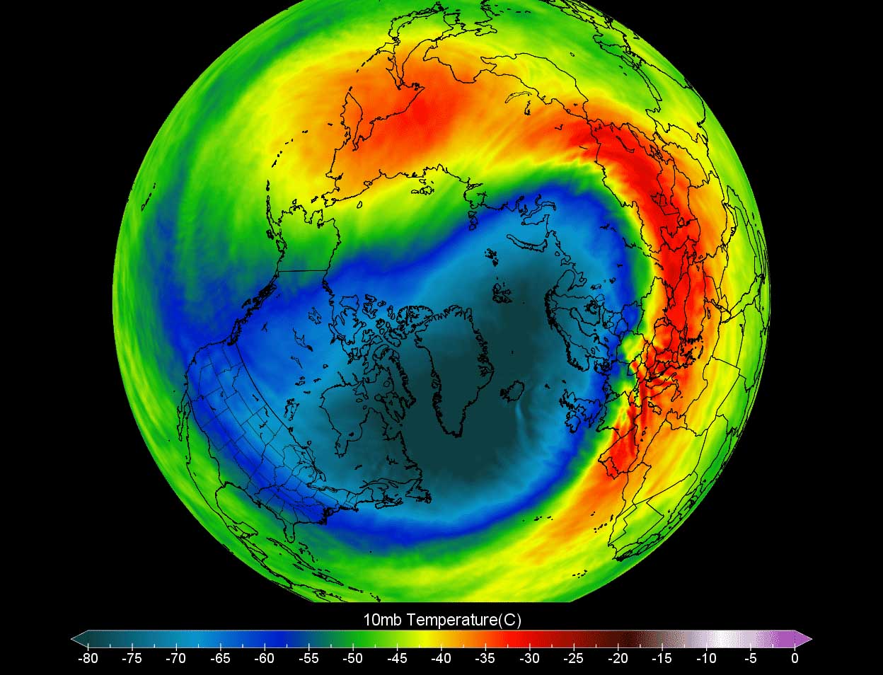
The weather model chart above hints at a typical situation of the Polar Vortex when it is fully established above our heads. The chart is representing the pressure at around 30 km (18 miles) altitude. This area is near the top of the stratosphere layer during winter.
The cold season 2021/22 had an unusually active and strong Polar Vortex, which was the main trigger behind all the cold outbreaks and winter storms over the North American continent in recent months. Its most intense part, known as southern lobe, was on the American side of the northern hemisphere for most of the winter. Although it has shifted towards Europe and northern Asia in early March, it was also forecast to soon collapse as the spring season arrives.
THE FINAL BREAKDOWN OF THE INTENSE POLAR VORTEX OF 2022
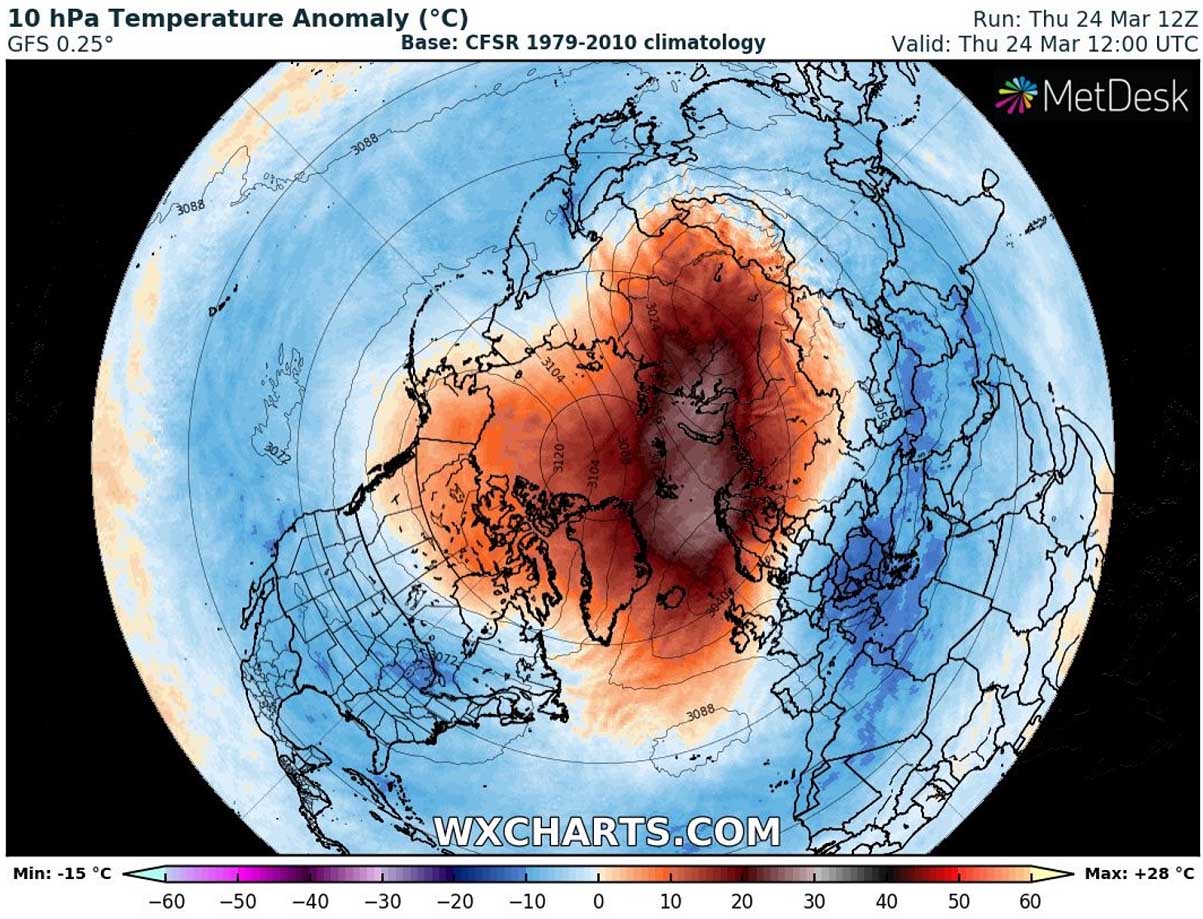
As we learned, our daily weather is pretty much related to the activity of the Polar Vortex, so we are monitoring its intensity and behavior. We usually look at the temperatures and their anomalies at the 10 hPa pressure level, this is directly inside the stratosphere layer we discussed above. This level is placed at around 30 km altitude.
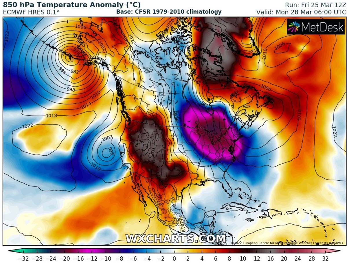
The Polar Vortex during February and even into early March 2022 was very intense and cold, but then a rapid breakdown has occurred through mid-March as we discussed in one of our recent articles. The core is much warmer while the colder air has shifted into mid-latitudes.

Temperatures in the core of the Polar Vortex have warmed up to -30 to -40 °C, which is nearly 40 degrees warmer than it was just a few weeks ago. The remnants of the cold are the strongest over North America, with still around -60 °C at the 10 hPa level. The collapsed Polar Vortex sent the energy back down towards the Earth’s surface, changing the weather patterns over North America.
The temperature anomaly chart below is revealing how warmer are the temperatures over the North Pole right now, nearly 30 °C above normal for the end of March, which is pretty extreme to say at least. Basically shows the Polar Vortex is completely gone in the upper parts of the atmosphere.
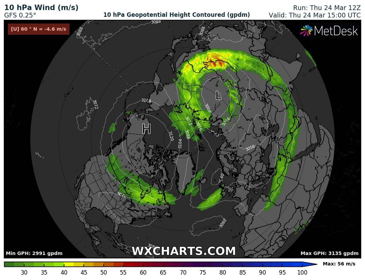
From the theory of winds, we know that the direct result of the temperature difference between air masses translates into the intensity of winds. Therefore, the intensity of the Polar Vortex circulation is much stronger during a cold season when the temperatures are far apart from each other.
After the collapse and significant warming of its core, the temperature difference was much lower, so the vortex is currently spinning with only around 125 mph (or 200 km/h) up there, about 50% weaker than in February.
During the early spring season, we normally expect the conditions to finally wind down and begin weakening as the cold winter is coming to an end. This is the process we see every winter and spring, of course.
So, to conclude, despite the rapid breakdown of the Polar Vortex recently, the remnants of the cold are pushing down towards Canada and the United States this weekend, bringing a dramatic temperature change with nearly 30 degrees colder than normal weather for a few days.
NORTHEAST U.S. TO EXPERIENCE UNUSUALLY INTENSE SPRING SEASON COLD
As we discussed earlier, the collapse and breakdown of the Polar Vortex usually lead to changing weather patterns, exactly the case we will be seeing in the coming days and weeks.
This weekend, a textbook dipole weather pattern is established across North America, meaning a strong upper High will strengthen across the western parts. To the east, a deep upper Low will dig far south into the eastern United States. This will bring another blast of frigid cold air from the Arctic region, unseasonably strong for the spring season.

Typically with such a weather pattern, a high surface pressure develops under a blocking High aloft, it will expand across much of central Canada into the United States. The surface vortex (cyclonic low) under the core of the Polar trough helps to create a strong pressure gradient against it. In other words, northerly winds will increase in the channel between the two features.
The following chart below hints at actually particularly large pressure difference between central Canada (1033 mbar) against the core of the cyclone over the Northeast U.S. and New England (992 mbar), so a more than 40 mbar difference.
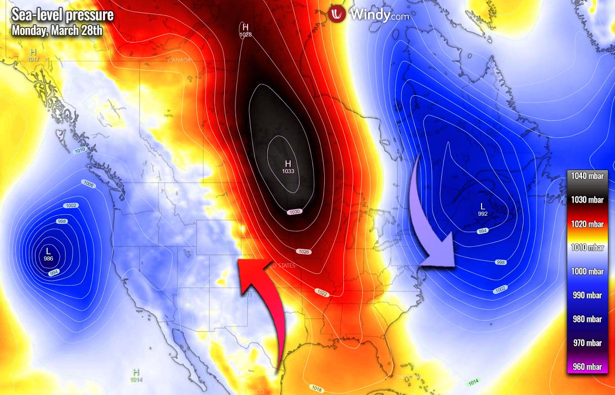
The tight pressure gradient enhances winds that will lead to a massive transport of much colder Arctic air mass from central Canada towards the eastern part of North America, with eastern Canada and Northeast U.S. at the core of this powerful blast. The general wind flow is purely meridional, coming south directly from the north.
First, a significantly colder than normal Arctic air mass will spread southeastward from central Canada prairies into the Great Lakes late Saturday into Sunday, advancing further through early days next week. Putting regions from the Upper Midwest across the Great Lakes to the Northeast into deep freeze again.
The air mass will be more than 25 °F (20 °C) below average for the end of March. While the West will be under a strong warm wave.
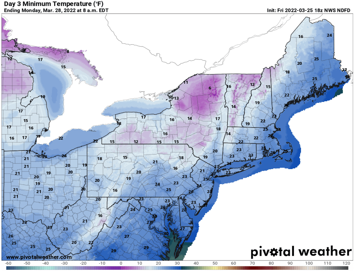
Daytime temperatures will be around 20 degrees below normal for tens of millions across the Northeast United States and New England on both Sunday and especially Monday as the core of the cold will be right above the region. The winter season feels will return, with Monday morning being particularly cold.
The morning lows will likely end up into the low 20s across Ohio, and Pennsylvania to Maine, even colder across New York state. Mid-10s are likely for many, even single digits across the far northern parts of the state. The very cold morning is also forecast over the Lakes and across the international border into southern Ontario.
Washington D.C., Philadelphia, New York City, and Boston will bottom out in the low 20s.
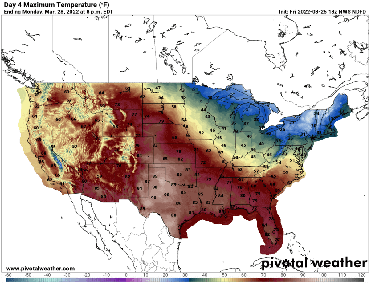
The cold pool will be pretty deep and widespread, bringing the highest daily temperatures across major cities just shy above freezing on Monday, low 40s in Washington D.C. Strong winds will get the real feel even lower, as breezy northwesterly will be present for several days. It will be a pretty cold Monday from the Upper Midwest to New England.
Farther west, it will be much warmer across the southern and central Great Plains. Texas could see Highs in the low 90s on Monday.
When we want to see how anomalous are the temperatures with the Arctic outbreaks, we use the Meteogram charts. Attached below is the weather forecast for temperature in Boston for the next 14 days. It clearly reveals that the new cold blast will be very strong. While the Northeast U.S. is currently just slightly above normal temperatures for this time (37 °F or +3 °C), it is forecast to drop significantly over the weekend.
The temperatures will fall from nearly 45 °F (or 30 °C), to around -6 °F (-21 °C) on Monday afternoon when the core of the low parks above.
Notice also how, in response to a returning advection of much warmer air mass next week, a massive warmth follows. In just 48 hours after the Arctic blast, a remarkable temperature rise of more than 55 °F (30 °C) occurs as the cold departs New England.

We can also see (bottom part of the chart) that the cold intrusion will also remain pretty dry, so not favorable for any significant snowfall. Apart from the Great Lakes region where lake-effect snow will develop in some areas.
MAJOR LAKE-EFFECT SNOW WILL DEVELOP ALONG THE LAKES ONTARIO AND ERIE
The cold season often brings frigid cold air mass traveling from Arctic Canada towards the southeast, spreading across the Great Lakes quite frequently. This effect leads to cooling down the lake’s water and freezing its surface. This arrival of warmer weather with the spring season is melting the ice cover pretty quick, so there is only about 20 % of the area under the ice, as NOAA reported.
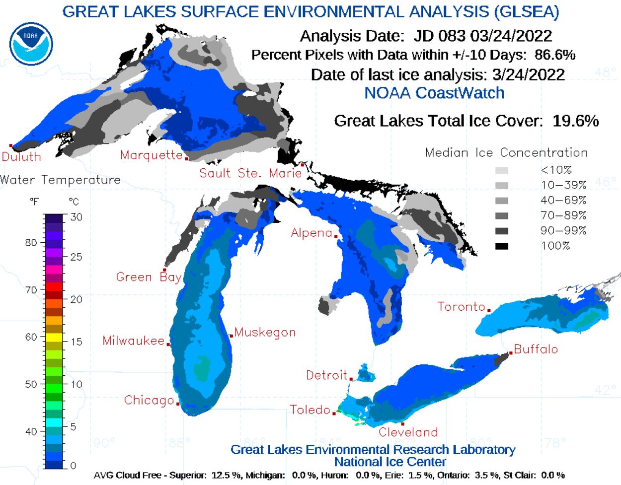
The highest total ice coverage is over Superior lake, about 12.5 % as of March 24th, other lakes have only some parts left with chunks of ice. The above chart indicates how the lake temperatures are gradually warming up, which is pretty important when the extremely cold air overspreads them.
The highest ice cover was nearly 60 % at the end of February as we can see from the following chart, about 15 perfect above the historical average. The zig-zag chart can surely hint us how dynamic the weather patterns were during the recent cold season, as the total Great Lakes ice cover was varying from 20 to 60 % from mid-January to late March.

Until the ice coverage is very small, the Arctic cold blasts from Canada develop the lake-effect snow across all of the Great Lakes. Generally speaking, the more ice-free the Lakes waters have, the higher potential is there for the heavy snowfall. With now warmer water than during the cold season, this just adds more fuel (moisture) into the convective snow bands that develop within the cold air.
The lake-effect snow is a pretty common occurrence across the Great Lakes region during winter and early spring season months. It develops when very cold air, often originating from Canadian Arctic, moves across the much warmer waters of the Great Lakes.

As the cold air mass advances over the unfrozen and warmer surface water temperature of the Great Lakes compared to the coming air, warmth and moisture are transferred into the lowest portion of the atmosphere. With the air rising, clouds form, growing into a narrow band that produces heavy snow bands with 3-5 inches or even higher snowfall rates.
The key component in this particular process is the wind direction as it determines which areas will receive the heaviest lake-effect snow. The most intense snowfall typically occurs in very narrow bands, known as snow squalls. It may be falling heavily in one location, while the sun may be shining just a mile or two away in either direction of the band. This is how sharp edges could develop in these snow bands.
Significant lake-effect snow will likely develop along the southeast shores of lakes Erie and Ontario. Some areas could see near 10 inches or even more snow through Tuesday. Some decent amounts of snow are also forecast across the Appalachians, northern Wisconsin, and Michigan.
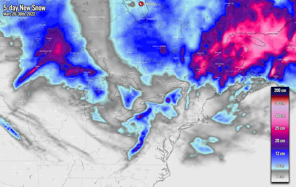
Canada’s Ontario as well, with some huge amounts of snow over far eastern Canada where strong moisture pool on the eastern side of the deep low will mix with the arriving cold. Even 1-2 feet of snow (40-60 cm) could accumulate there through the next five days.
Images used in this article were provided by Windy, Pivotalweather and Wxcharts.