Winter 2024/2025 is well underway, featuring strong temperature changes across North America. A new strong wave of cold weather is coming for the central and eastern United States next week, followed by a warmup over the whole of North America for the rest of the year. But a strong trend is emerging for January 2025 to bring back a prolonged Winter pattern.
Currently, a strong jet stream in the Pacific is helping to push a warmer pattern over the U.S. and southern Canada. But that will soon change, as cold polar air will spread from southern Canada into the central and eastern United States.
While these are strong weather dynamics on a daily to weekly time scale, a broader Winter pattern change is developing for January 2025. At the present time, forecasts indicate a return of a low-pressure area and colder air over the central, northern and eastern United States.

WINTER WEATHER AND THE JET STREAM
The current weather pattern across the North Pacific and North America features a strong jet stream. In the image below, you can see the latest pressure anomalies that formed in a wave-like pattern of highs and lows. Such pressure waves are an attempt of the atmosphere to balance out the temperature difference between the cold poles and the warm tropics.

A strong low-pressure system over the North Pacific helps to amplify a ridge over the United States, driving a warmer weather pattern.
You can see this in the image below, with a warm anomaly over most of the United States and southeastern Canada. But a cold anomaly wave is starting to appear over the southwestern Canada, and is set to expand and drop into the central and eastern United States early next week.

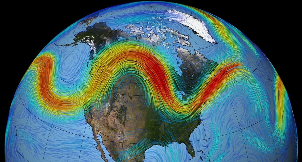
These temperature patterns directly correspond to the high and low-pressure systems. These pairs of pressure systems are also known as Rossby Waves. You can see an example of Rossby waves in the image below by NOAA. The real pressure anomalies can be more complex than this example, but all pressure systems are connected with the jet stream.

The purple line connecting these pressure systems is called the jet stream. This rapid stream of air is found around 9 to 14 kilometers (6 to 9 miles) above sea level. It drives and interacts with the pressure systems, thus helping to directly influence our daily weather. That is why any changes in the jet stream are very important to monitor.
The term jet stream is often behind extreme events, from cold spells and flooding to heatwaves and droughts. It is a fast, narrow current of air flowing from west to east that surrounds the globe. The image below shows an example of the global jet stream in a NASA visualization.
This is even better seen in the high-resolution video animation below, which shows the flow and movement of the jet stream across North America. It was developed by the NASA/Goddard Space Flight Center Scientific Visualization Studio.
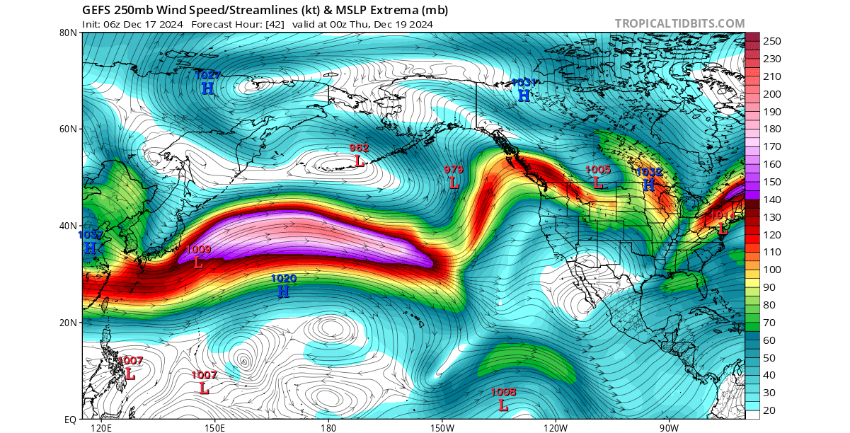
Below is the jet stream forecast for the next two days. You can see the amplified jet stream over the Pacific and its curving over North America. Those curves in the jet stream over North America will evolve and start a cold weather event by early next week.
There is a reason why we are learning about pressure waves and the jet stream. It helps us to better understand the movement and development of weather patterns, especially when we forecast or expect large-scale weather pattern changes.
FINAL COLD OF THE YEAR
Looking into later this week, a low-pressure area is forecast to move from the northern into the eastern United States. That will enable a strong northerly flow across the central and especially the eastern U.S., transporting the colder airmass of this season so far. Images by: weathermodels.com
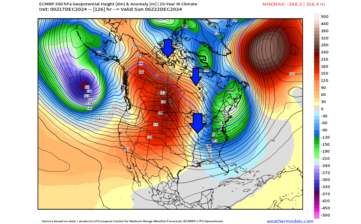
We can also look at the jet stream forecast for this period, where you can see a strong, almost vertical jet stream over Canada and the eastern United States. This is what drives the northerly flow into the United States, bringing down a cold polar air mass.

To put that into perspective, you can see the temperature forecast image below. It shows the surface temperature anomaly for Sunday. You can see an extensive cold air anomaly over the eastern and parts of the central United States, even reaching as deep as the southeast coast, but less cold as it moves deeper south.

The western United States and Canada will be under a strong warm air anomaly. It will be driven by a rising high-pressure anomaly, which is forecast to move deeper into the continent and impact the weather for the rest of the year.
Looking at the 5-day temperature anomaly from this Thursday to next Tuesday, you can see the full extent of the upcoming cold air event. Most of the eastern half of the United States and southeastern Canada will be covered by the cold polar air mass in this event, which will also be the last cold event of 2024.

Looking at the total snowfall forecast until Christmas, you can see the whole of southern Canada and the northern half of the United States experiencing snowfall. But while the upcoming air mass will be cold, there is not a lot of precipitation in the forecast, which limits the snowfall potential.

The main snowfall belt in this event will expand over the northern Plains into the upper Midwest, the Great Lakes, and the northeastern United States.
Depending on the timing of the cold front and the location of the low-pressure center, the forecast shows that states of the northern Plains, upper Midwest, around the Great Lakes, and the northeastern U.S. will have a white Christmas morning.
After this event, a high-pressure anomaly is forecast to expand back over North America, bringing along unusually warm temperatures over the whole continent. But it will not last long into 2025.
A WARM WEATHER PAUSE
Looking at the final week of December and the final week of 2024, you can see a strong high-pressure anomaly covering the eastern United States and Canada. An anticyclone system spins clockwise, enabling a strong southerly flow over much of North America.

You can see this strong warm transport in the surface temperature anomaly map below. Temperatures will be above normal throughout the post-Christmas period, with unusually high anomalies over eastern Canada.

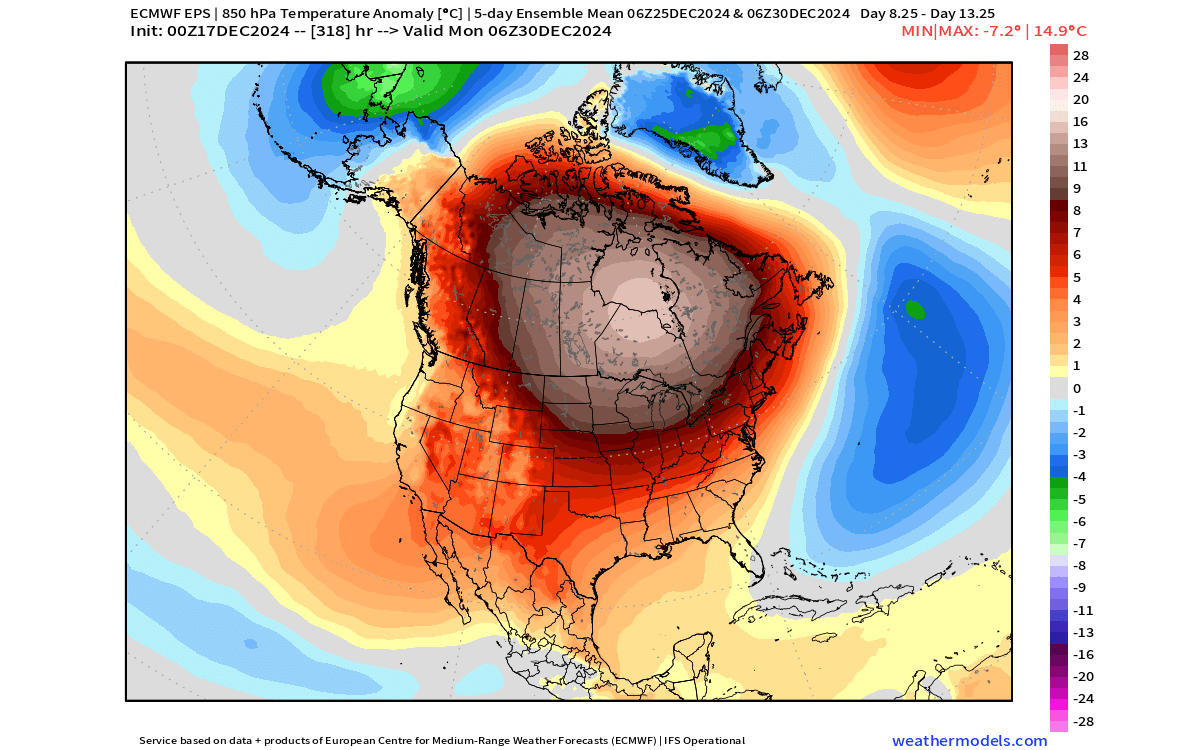
Looking at the temperature anomalies at the 850mb level (1500m/5000ft), we can understand the overall airmass above the surface level. You can see that most of North America will be under a warm airmass in the final week of the year. There is even a proper warm “dome” over Canada, directly under the high-pressure anomaly.
Looking into January and early 2025 with the normal forecasting tools can be a bit of a stretch. But what we can do, is look at the early trends and large-scale anomalies and signals. So the following forecasts should be taken for what they are, just the latest forecast trends and ideas.
NEW YEAR, NEW WINTER PATTERN
Looking at the extended-range forecast trend for the first week of January, you can see the ridge rising to the northwest. A low-pressure area returns over southeast Canada and the eastern U.S. This pattern can bring a likely northerly flow into the Midwest and the eastern United States.
The temperature forecast trend does show a negative anomaly over the central, northern, and eastern United States. This anomaly is supported by the low-pressure area pattern, helping to sustain a northerly from from Canada into the United States.
The only concern here might be how cold is the source region in Canada while it is still under a warmer-than-normal airmass. But even if the temperatures are, let’s say, 5 degrees higher than normal over central and northern Canada, it means that instead of -15°F, the air mass is at -10°F, which is still plenty of could for transport to the south.
It is usually advisable to look at different forecast solutions at this extended range, so we also looked at the GEFS extended ensemble forecast. This model also hints at the return of a low-pressure area over the northeastern United States and southeastern Canada. But compared to the ECMWF, it is a bit further east and a bit slower to shift from warm to cold.

The temperature trend from this model for early January shows the return of below-normal temperatures over the eastern United States. So, while it does not show a very strong cold signal, what we really want to see at this range is just the indication of a change in weather patterns.

But this model has a limited range, and going further out does “water down” the signal, so we won’t use it beyond this point.
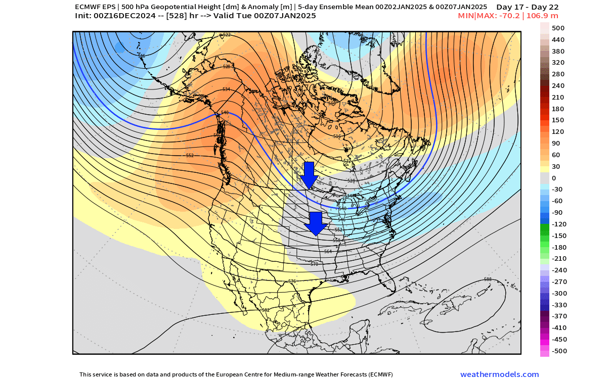
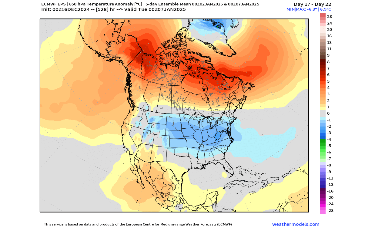
COLD PATTERN CONTINUES
Going deeper into the extended-range forecast trend for the second week of January, we see a further evolution of the pattern and a more vertical jet stream again. A broad low-pressure area sits over the eastern United States and southeastern Canada. This indicates a more proper “cross-polar flow” which usually brings the cold air deeper from the within polar regions.
The temperature forecast for the same period does show a broad cold-air anomaly over much of the northern, central, and eastern United States. At this forecast range, the anomaly is never really that strong on the maps, as it gets averaged out the further out we go. But for this range, this is still an impressive anomaly to see.
The snow forecast for the first half of January does show a good trend for most of the northern and northeastern parts of the U.S. and also for the central states. This is just an ensemble average at a very extended range, so it serves as a trend. It does show snowfall potential coming with the pattern change.

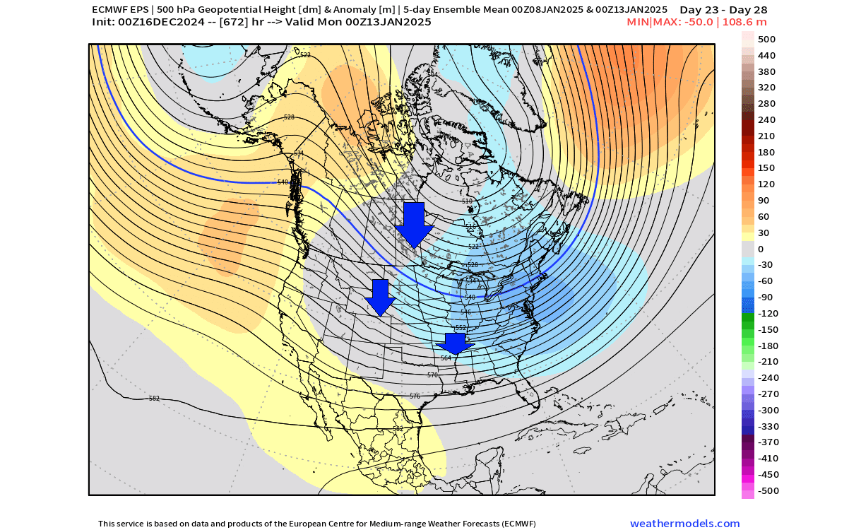
We can also take a quick look at the start of the second half of January. As you can see, the forecast currently indicates the low-pressure area to move back into the northwestern U.S. and western Canada. That enables a high-pressure ridge to briefly form over the eastern U.S. and Canada.
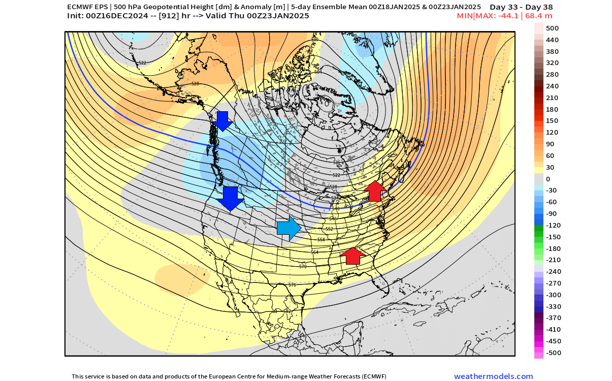
The arrows in the image show the likely airmass movement with these pressure systems. The colder air is more reserved for the northwestern United States and western Canada. At the same time, a ridge brings normal to above-normal temperatures to the eastern United States and southeastern Canada.
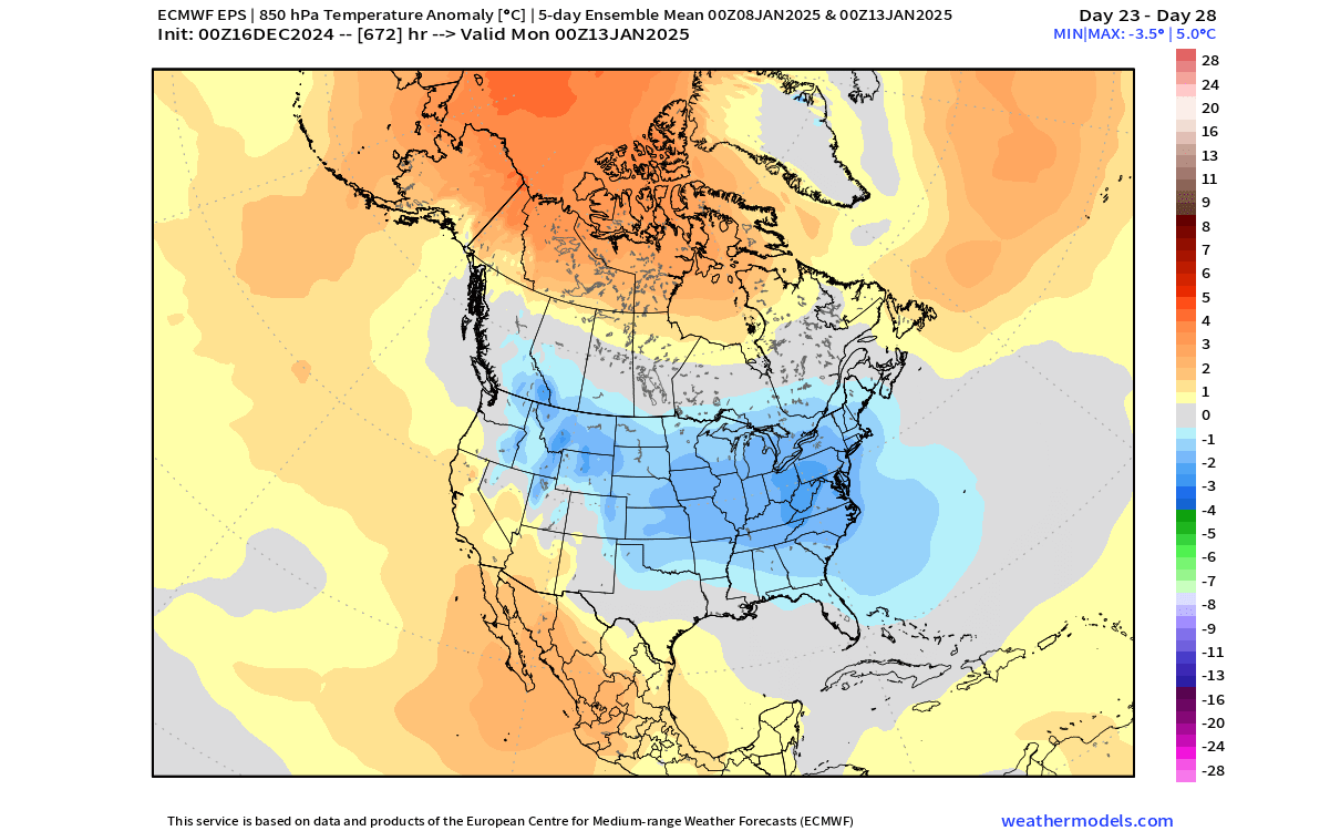
This is also seen below in the temperature forecast image for the same period. The colder airmass is over western Canada and the northern United States, while a more westerly flow brings a temperature rise to the central and eastern United States.

But in this range, this is just a current trend. And the real value of this forecast will be when we compare it next week with a fresh foreast. Then, we can compare the change in the development of this forecast and if the trend moves perhaps towards a colder solution or a warmer solution for certain parts of North America.
We will keep you updated on the developing weather trends in the coming weeks, so make sure to bookmark our page. Also, if you have seen this article in the Google App (Discover) feed, click the like and follow button there to see more of our forecasts and our latest articles on weather and nature in general.
Don’t miss: Winter 2024/2025 Final Snowfall Predictions: An early start, with a Cold air reserve lasting into mid-Spring