The latest runs of Winter 2024/2025 snowfall predictions for Europe, show a rather weak snowfall season in mid-late winter. While the weather pattern forecast has indicated some potential mid-winter, the problem seems to be the cold air and moisture overlap.
A good snowfall season needs both cold air and also precipitation. The colder air usually holds less moisture, so we need more specific weather situations to produce plenty of snowfall.
In this article, we will look at the snowfall predictions month-by-month for Europe, using the two leading global long-range forecasting systems. The latest forecast now also includes the data for April, so we can also look at the mid-Spring snowfall trends.

WINTER UNDERWAY
Meteorological winter began on December 1st and will last until the last day of February. It covers the 3-month period that is statistically the coldest quarter of the year, so all official winter stats are taken in this period.
The total snowfall forecast for the next 10 days shows the bulk of snow to fall over the northern and eastern parts of the continent. Some snowfall is also seen across central Europe, but more in the higher elevations. Another region with more snowfall potential is seen over the southeast.

Looking towards the final third of the month, we can mostly look at the developing weather pattern trends. The forecast shows a high-pressure area rising over the Atlantic. That can enable a pressure drop and northerly flow over central Europe, increasing the snowfall potential in this period.

That scenario can be seen in the temperature forecast below, which shows a cold anomaly returning into much of central and southern Europe. We don’t have a reliable precipitation output from this forecasting system, but having a colder airmass is the first step to a better snowfall potential.

Below is the video animation, which shows the weekly temperature trends for Europe from mid-December to early January. You can see the developing cooling trend. Images in the video are from tropicaltidbits.com
At this point, this starts to raise hope for a colder pattern around the holidays. While this is just a trend forecast, it’s the first thing you usually want to see at this range if you want to hope for some snowfall. We will monitor this period as it gets closer in the forecast.
FINAL WINTER SNOWFALL PREDICTIONS
The format of this snowfall forecast is simple. We look at two well-established seasonal weather forecasting systems, the ECMWF and the UKMO. The data used to produce these images is the latest available, from mid and late October.
You will first see the seasonal average snowfall forecast for December-January-February, and then we will do a monthly breakdown. There are a lot of details in the monthly forecast that the whole seasonal average cannot show.
These forecasts show the snowfall anomaly. This means it shows the areas forecast to receive more (or less) snowfall than normal. For example, if an area is forecast to receive less snowfall than normal, it doesn’t mean it will receive no snow. It just means less snowfall than usual is expected.
ECMWF 2024/2025 SNOWFALL FORECAST
As always, we will start with the ECMWF, the most often used and highly regarded seasonal forecasting system.
The latest seasonal average shows below-normal snowfall over most of the continent. Some areas of increased snowfall are forecast over Scandinavia due to the influence of a low-pressure system and the jet stream over northern Europe and further ahead towards the east.

But let’s look at the seasonal forecast change. You can see that the latest forecast shows a bit more snowfall than the previous forecast over parts of the United Kingdom and southwestern Europe, and over the Balkans. A larger increase in snowfall is evident over the far north due to the more amplified jet stream in the latest forecast.

The January forecast continues the reduced snowfall potential over much of the continent. Overall, the forecast is very similar to the seasonal average, with perhaps even less snowfall over the central parts.

February shows no real improvement, with most of the continent still under much less snowfall than normal. This is perhaps surprising, as there were indications in the pressure pattern forecast for February that more cold could be available. But this could also result from less precipitation despite lower temperatures.

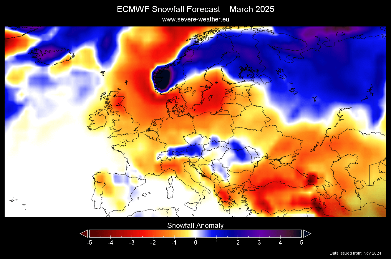
Below is the March snowfall forecast, showing an improved snowfall potential over central and southwestern parts (besides the usual far north). This indicates a potentially disrupted pattern in late winter and early spring.
We can also take a first look at the mid-spring snowfall potential. Overall, April shows less snowfall than usual for this time of year, except for higher elevations across central parts. This indicates enough precipitation but a lack of proper cold air to also bring snowfall to the lower levels, as usual in recent years.

The ECMWF forecast shows a rather weak snowfall season, mainly struggling with the proper overlap between precipitation and cold air. But will the UKMO forecast show more potential?
UKMO WINTER 2024/2025 SNOWFALL
We use the UKMO long-range forecasting system along the ECMWF to estimate how “dependable” each forecast is. If both forecasts show a very similar image, it gives a higher confidence in the overall accuracy.
The seasonal average for Europe shows another very weak snowfall forecast, just like the ECMWF. Most of the continent is forecast to have less snowfall than normal, except for the far northern parts under the jet stream.

But compared to the previous forecast data, we can see that the latest forecast actually shows more snowfall over the south-central and southern parts of Europe. And, of course, over the far north with a stronger jet stream in the latest forecast. The rest of Europe has less snowfall in the latest forecast run compared to the previous one.

UKMO January forecast shows less snowfall deficit than the overall average. So, while the red colors show less snowfall than normal, it does matter if the forecast shows -1 or -5, as a lower deficit still only means less snow than normal, not no snow at all.

February shows no improvement, with some areas having an even larger snowfall deficit than January. This is again linked to overall less precipitation this month, along with a lack of cold air in the model itself.

The March forecast shows a weak snowfall trend in early Spring, except for the far northern parts again. Some snowfall indications are further out towards the southeast, but overall, the continent is forecast for a very slow start to the spring snowfall season.

UKMO also has the April data in its range, giving us a look at the mid-spring snowfall potential. Like the previous model, UKMO also shows less snowfall than usual for this time of year and the first half of Spring overall, mostly due to a lack of cold air.

We will keep you updated on other developing weather trends, so bookmark our page. Also, if you have seen this article in the Google App (Discover) feed, click the like button (♥) there to see more of our forecasts and our latest articles on weather and nature in general.
Don’t miss: