A new Polar Vortex is now forming over the North Pole, with rapid stratospheric cooling and a pressure drop already visible in the latest data. It is starting the season stronger than last year, but the long-range forecasts show a very different signal for Winter 2026/2027.
New seasonal trends agree on a notable slowdown of the Polar Vortex around mid-winter, with weakening winds and rising pressure in the stratosphere. A strong Super El Niño is also developing in the Pacific, adding another factor affecting the Polar Vortex winter development.
In this article, I will look at the new Polar Vortex development from Fall to Winter 2026/2027, the Super El Niño connection, and what a major disruption or a Polar Vortex collapse would bring for winter weather across the United States, Canada, and Europe.
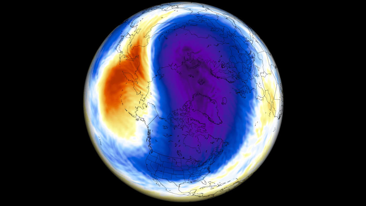
Polar Vortex: The Engine of Winter Circulation
To keep it simple, the Polar Vortex is the broad winter circulation over the Northern (and Southern) Hemispheres. You can imagine the Polar Vortex as a spinning wall over the polar regions, rising from the surface into the stratosphere (over 50 km/ 30 miles high), keeping the cold polar air inside.
As you can see in the image below, the Polar Vortex is divided into two layers that we monitor each winter: the stratosphere and the troposphere. The first is at a higher altitude, and the second is at a lower altitude. The Polar Vortex rises high through both layers, but with different shapes, strengths, and impacts.
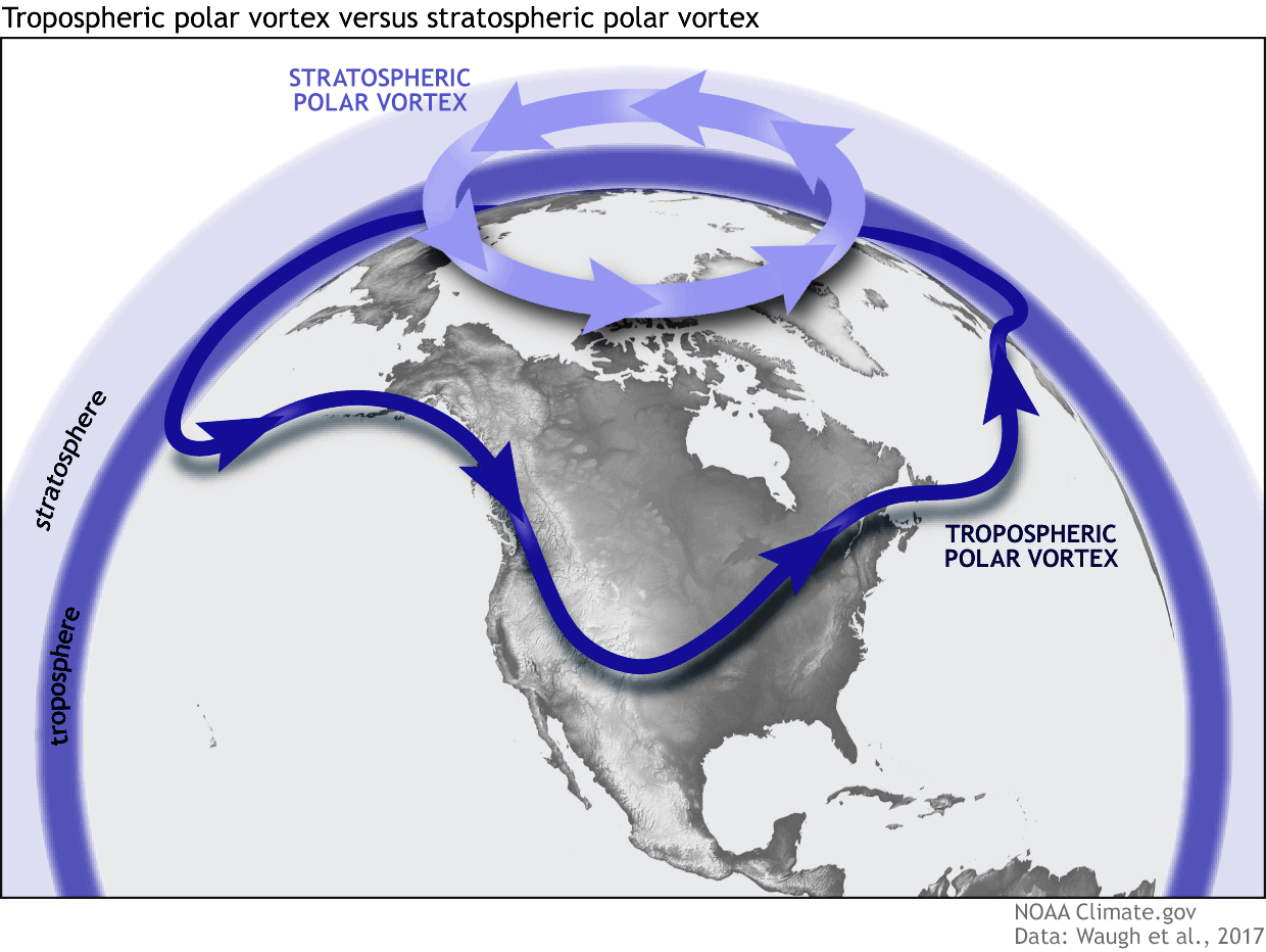
The upper (stratospheric) part of the Polar Vortex is more symmetrical and stronger, as it spins more freely higher above the ground. But the lower structure is much more uneven and “wobbly.” This is due to the influence of terrain and mountains, along with strong pressure systems that act as obstacles in the flow.
In the image below, you can see a true 3D analysis of the stratospheric Polar Vortex, which I made from the GFS forecast data for October 1st, just for a visual example. I regularly use this approach operationally, as it’s a great way to visualize the actual Polar Vortex structure in the stratosphere, between 12-52 km (7.5-32 miles) altitude.
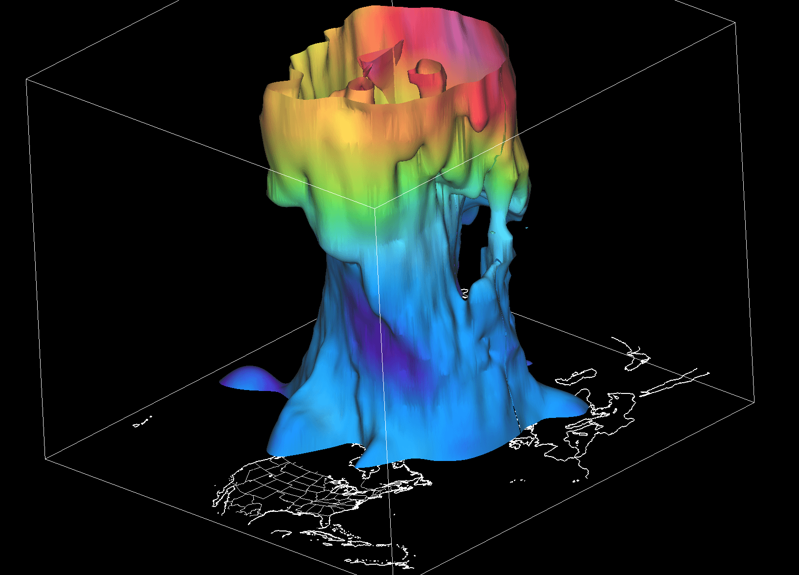
The vertical size is greatly increased to make it easier to analyze the true state of the Polar Vortex: any deformations in the structure, temperature patterns in the stratosphere, core development toward lower levels, and potential weather interactions.
As you can see in the example image below, at around 5 km (3 miles) altitude, the Polar Vortex is much more deformed. As we get closer to the ground, it becomes more deformed because of terrain, mountain ranges, and strong pressure systems, creating wave-like distortions around the Northern Hemisphere.
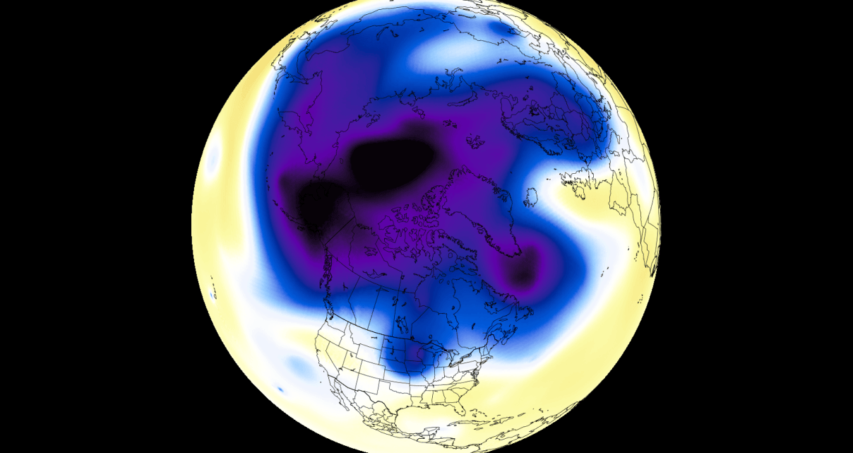
Notice the cold “arms” that extend colder air and snowfall into lower latitudes. These arms can create strong winter storms and Arctic outbreaks across the United States, Canada, and Europe. In many cases, these cold arms reflect what the upper (stratospheric) part of the Polar Vortex is doing.
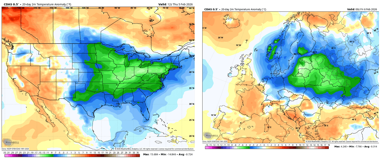
To show the strong Polar Vortex dynamics, I produced a high-resolution video below that reveals its evolution in 3D. This video shows the Polar Vortex structure disruption in early 2026, which brought a cold-air outbreak to the central and eastern United States and parts of Europe.
The disruptions can occur in various ways, but the most impactful is a Sudden Stratospheric Warming (SSW) event. This is a dramatic winter event in which temperatures high up in the stratosphere increase by several tens of degrees in just a few days, along with a pressure rise.
This rapid warming disrupts the Polar Vortex, weakening its strong winds or causing them to completely reverse direction and affecting the lower levels of the atmosphere.
Currently, a new Polar Vortex is already emerging for the 2026/2027 cold weather season, and it is starting out quite strong for this time of year.
A New Polar Vortex Now Forming for Winter 2026/2027
In the Stratosphere, the cooling usually starts in August and increases strongly over September and October. This creates a strong temperature difference versus the warmer southern areas, causing the pressure to drop and a cyclonic area (Polar Vortex) to develop over the north.
Below is the 14-day temperature change forecast for the mid-stratosphere at the 10mb level (30km/18.5miles altitude). You can see ongoing cooling over and around the North Pole in the stratosphere, with a cold core starting to develop over the polar regions.
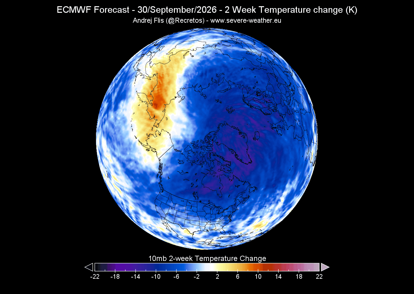
A cold core is the heart of the Polar Vortex, and the colder it gets, the stronger the Polar Vortex can become.
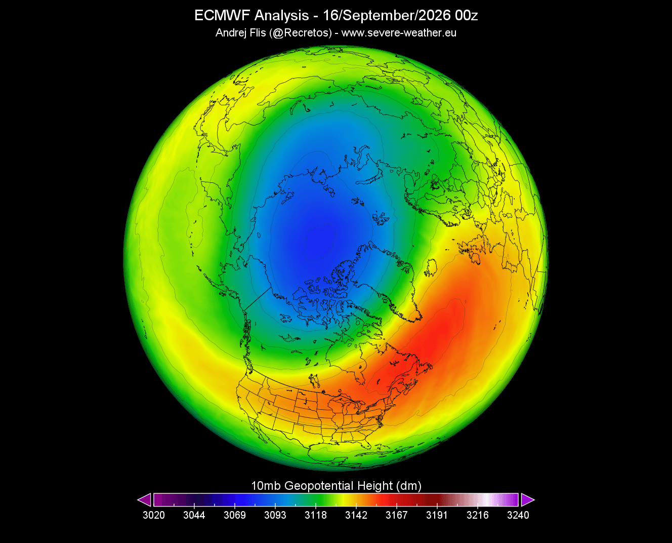
As a result, the pressure is also dropping rapidly. The image below shows the current geopotential height at the same 10mb level. You can see a visible low-pressure core with a well-defined closed low center, already developed over the polar regions. This is the brand new Polar Vortex, now growing for the upcoming Winter 2026/2027.
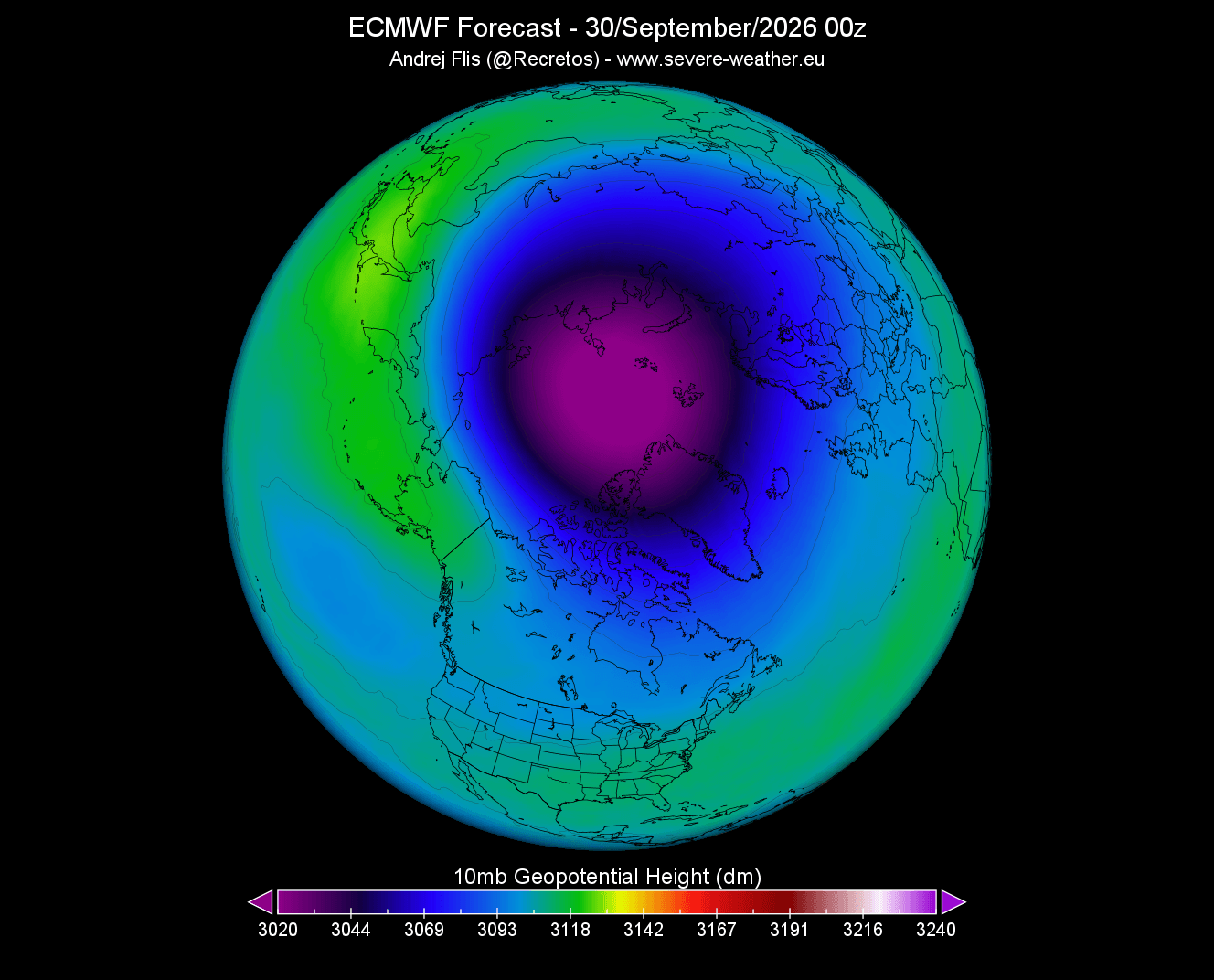
Looking at the late-month forecast, you can see the Polar Vortex becoming more developed and rapidly increasing in size and depth. I used the exact same scale as in the image above, so you can directly see what just 15 days of development means for the Polar Vortex as we head into Fall.
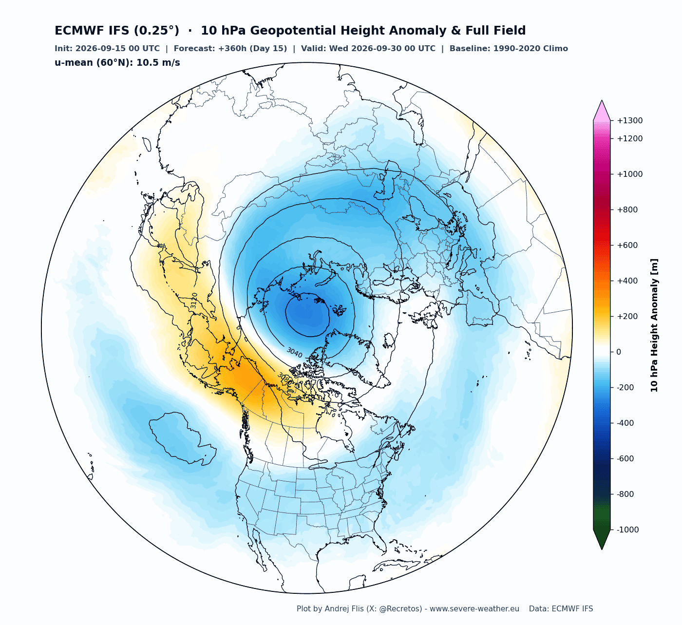
As the pressure drops in the Polar Vortex, it increases its wind speed and depth. In the image below, you can see the height anomaly forecast for the 10mb level (30km/18.5miles altitude), which shows the Polar Vortex core being slightly stronger than usual for late September. It also features a nice circular/cyclonic shape, visible by the height lines.
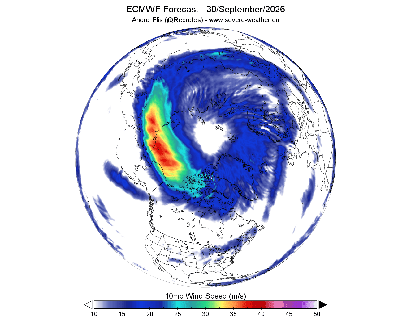
The wind forecast for the mid-stratosphere during this period also shows a clear circular or “donut” shaped wind stream. This shows that the Polar Vortex is organizing properly and trying to form a strong closed circulation.
But while things might look good for the Polar Vortex now, the latest trends show it will likely have a bumpy winter season and lose strength. And its strength really matters for the daily winter weather development.
Polar Vortex Forecast: From a Strong Start to a Mid-Winter Slowdown
When we look at a stratospheric Polar Vortex forecast, we usually try to determine which “mode” it is in. The stratosphere is very sensitive to vertical wave energy coming from below, which usually determines the behavior and strength of the Polar Vortex, and thus its mode:
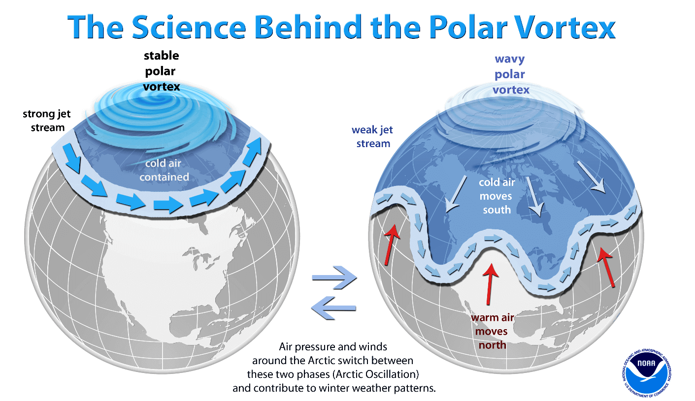
A strong Polar Vortex usually means strong polar circulation and jet stream. This can trap the colder air into the Arctic Circle, creating milder conditions for most of the United States and Europe.
A weak Polar Vortex can create a disrupted jet stream pattern and a strong weather response. As a result, it has a harder time containing the cold air, which can then escape more freely from the polar regions into the United States or other mid-latitude regions. Image by NOAA Climate.
The most common way we monitor the Polar Vortex strength is by looking at wind speeds around the polar circle. Strong positive winds indicate stable conditions or a strong Polar Vortex, but weak or even negative (easterly) winds indicate a complete reversal and a breakdown of the Polar Vortex.
Below is the latest analysis and extended forecast of the mid-stratospheric winds around the Polar Vortex. You can see the absence of a polar vortex during summer. But the winds turn westerly (positive) again as the sun angle reduces and temperatures and pressure drop in the stratosphere.
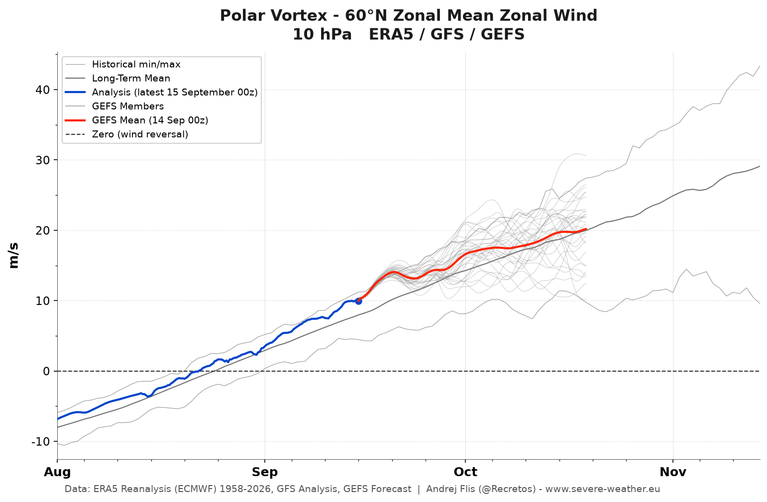
The extended-range forecast (red) shows normal to perhaps above-normal Polar Vortex strength currently, forecast to drop around normal in October. This is fairly normal, as the stratosphere usually shows mostly minor fluctuations in the early Fall season.
But looking at the seasonal forecast, you can see that things are expected to change quite dramatically. The latest seasonal data below shows a stronger Polar Vortex in early winter. But then we can clearly see an interesting deceleration and a potential disruption trend starting in early January.
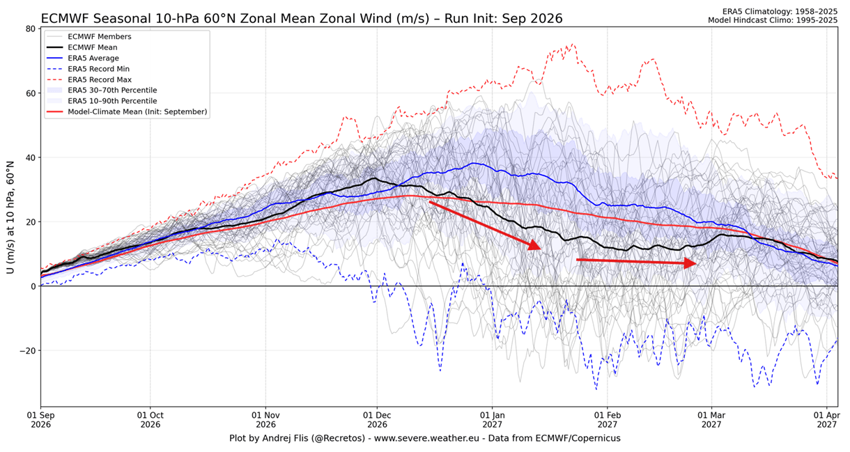
The forecast line (black) goes far below the long-term average line (blue) and the model’s own normal (red). This indicates a power drop or a disruption trend for the Polar Vortex in January/February 2027.
One way to also inspect the state of the winter Polar Vortex is to look at actual pressure anomalies over the Polar regions. Below is the seasonal pressure forecast from the surface up to the mid-stratosphere over the North Pole. You can first see a low-pressure anomaly in early winter, indicating a stronger early Polar Vortex.
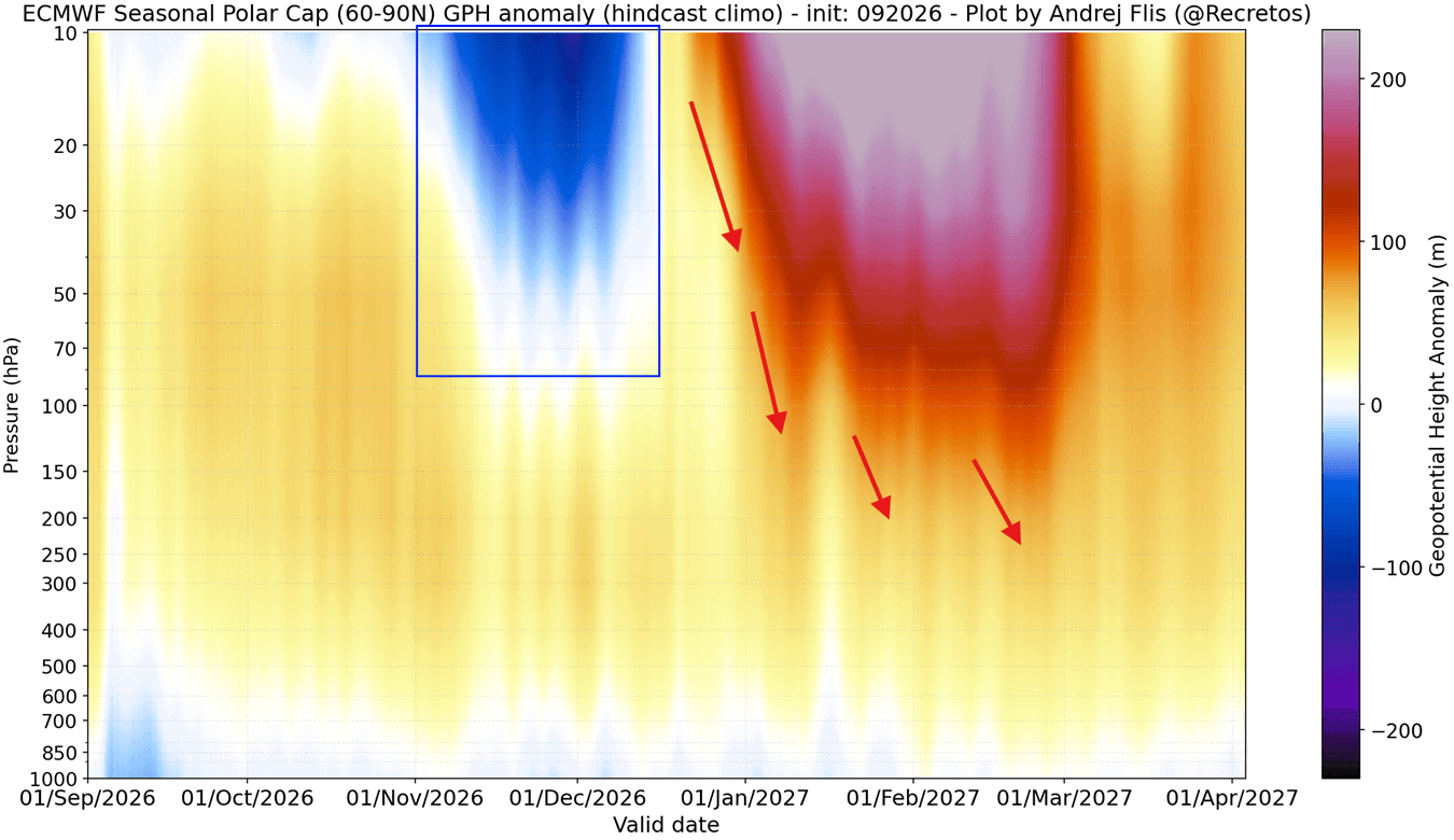
But the main focus is on the strong high-pressure anomaly in the middle and lower stratosphere, extending downward into the lower atmosphere. This clearly indicates a Polar Vortex slowdown and disruption around mid-winter.
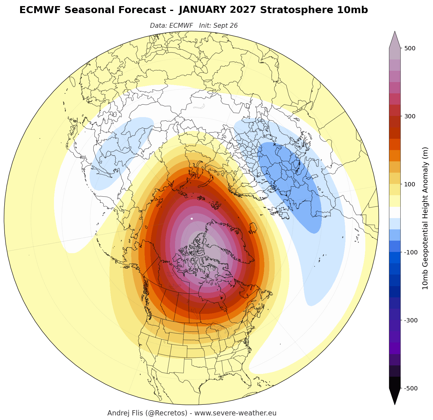
I also decided to look at the actual mid-stratosphere pressure anomaly forecast for January 2027. As you can see below, the forecast calls for a high-pressure anomaly in the stratosphere, indicating a weaker or disrupted Polar Vortex. This is a clearer signal that the Polar Vortex could be weaker this winter.
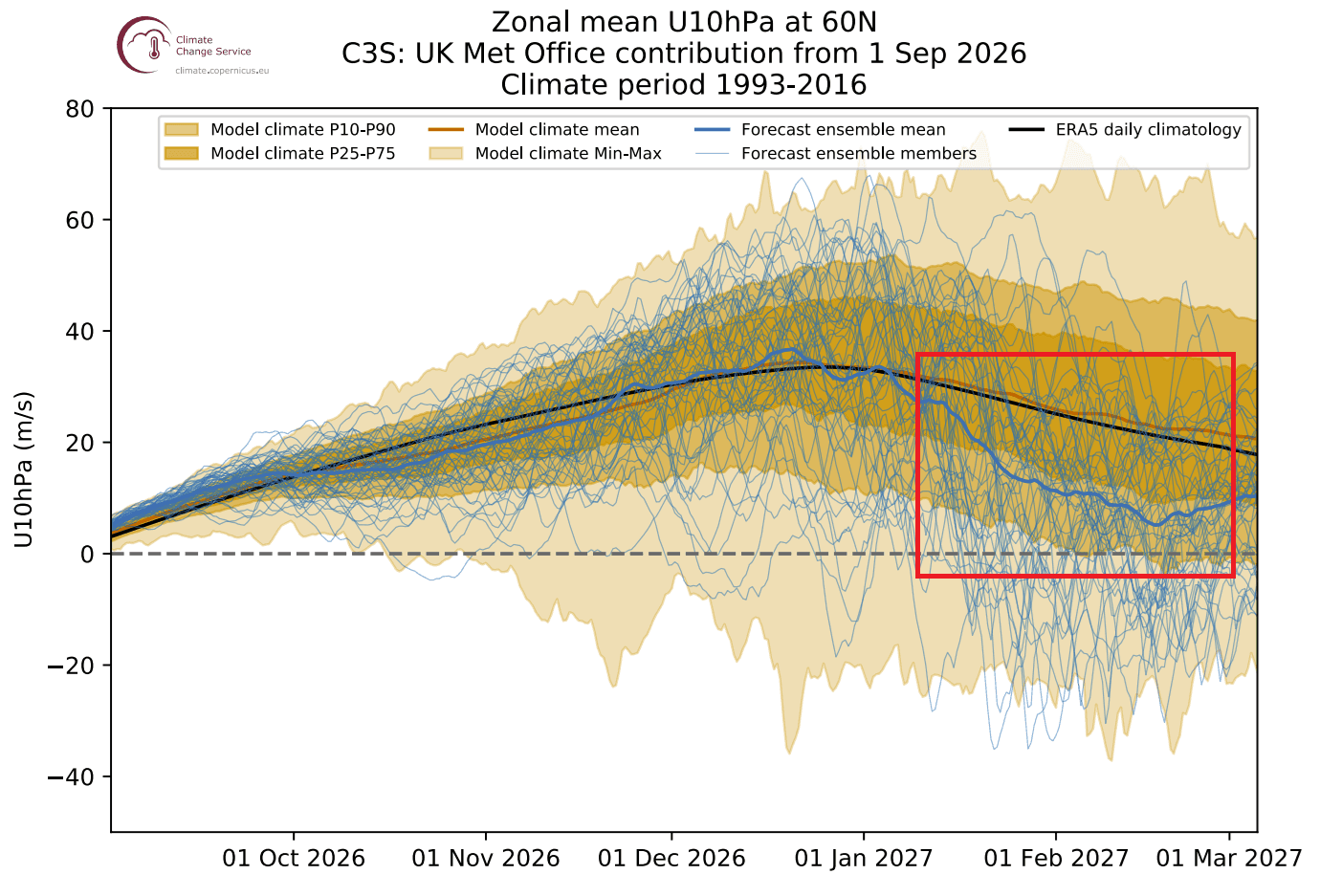
But this model is not the only one forecasting a potential Polar Vortex disruption. Below is the stratospheric wind forecast from the UKMO model, probably the second-best for the stratosphere based on my experience. It also shows a significant Polar Vortex weakening in mid and late winter, which is unusual to see this far out.
Looking at the overall context of these anomalies over the pole, we can start to see a signature of a Sudden Stratospheric Warming event (SSW). These trends really are as good as they can get for a September run, since no actual wind reversal can be accurately forecast this far ahead to the exact week.
But while we can’t forecast an actual SSW event accurately this far out, one major global factor could increase those odds this season: a Super El Niño.
Super El Niño: A Growing Threat to the Polar Vortex
We are currently observing a very strong El Niño event developing in the tropical Pacific. It is forecast to peak as one of the strongest such events in decades, and has a known historical impact on the Polar Vortex.
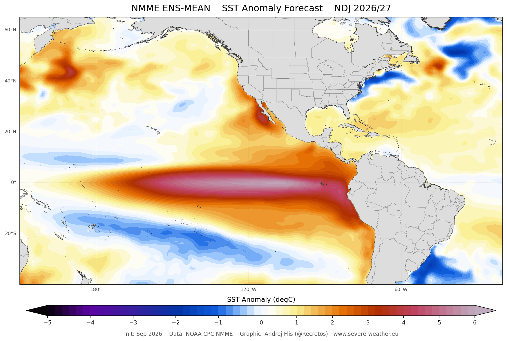
Below is the ocean temperature forecast from late autumn to mid-winter from the NMME model data. You can see a large area of strong warm ocean anomalies, which is the forecasted El Niño event. With peak seasonal anomalies over 5 degrees above normal, this is clearly a strong or Super El Niño in development.
This is reflected in the latest ENSO multi-model forecast seen below. It shows a very strong El Niño developing, exceeding the Super El Niño threshold (+2 degrees), with an immediate impact on the fall and winter patterns. The forecast average calls for this event as one of the strongest in decades, if not longer.
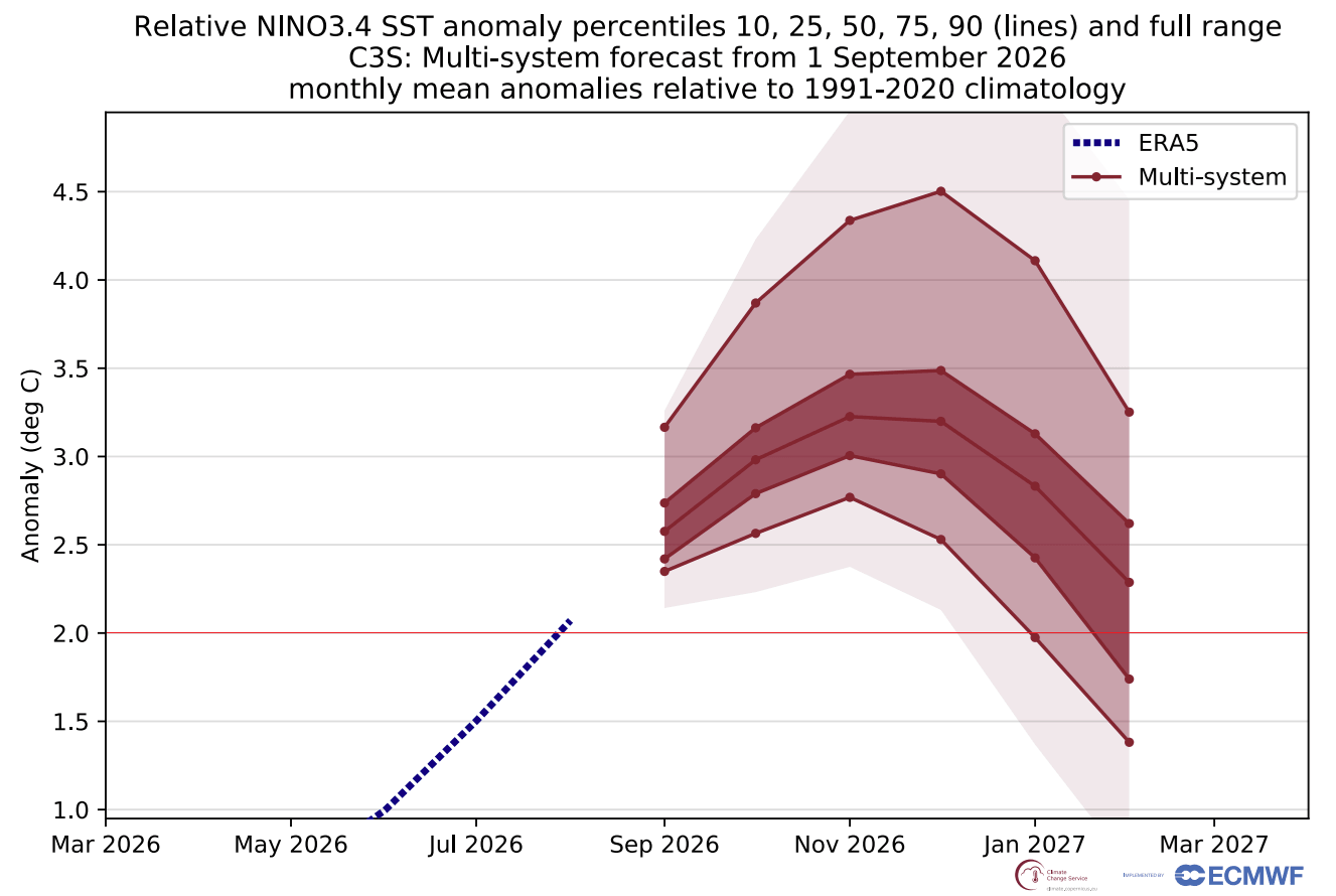
A Super El Niño event usually leads to more extreme weather shifts, amplifying normal seasonal changes into high-impact weather events. But El Niño strength also matters for the Polar Vortex and the Stratosphere.
Below is a winter atmosphere simulation from a recent study (linked below) that compared the Polar Vortex impact of El Niño (EN) across different strengths: weak (W), moderate (M), and strong (S). As you can see in the right panel, a strong El Niño shows a significant stratospheric deceleration of the Polar Vortex.
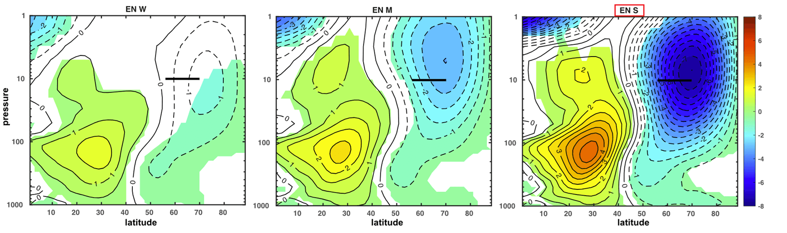
This supports the forecast data above, which shows a significant mid-winter deceleration of the Polar Vortex winds in the stratosphere for 2026/2027. And it also indicates as the Super El Niño as the very likely culprit behind it.
One of the reasons behind this can be seen in the image below. It shows the typical pressure anomaly before the SSW or a Polar Vortex disruption. On the right panel, we can see the mid-winter pressure pattern during an El Niño event. Overall, we can see that the El Niño pattern has some features that work against the Polar Vortex.
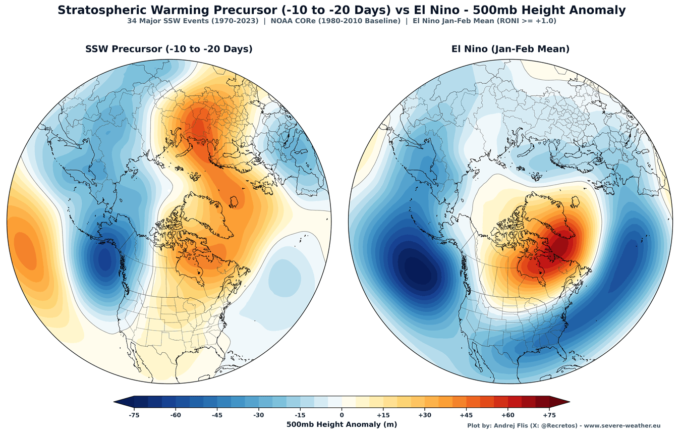
We see a low-pressure anomaly in the North Pacific and Aleutians, and a high-pressure zone over Greenland and north Canada. This planetary pressure-wave setup can send a lot of energy into the stratosphere, initiating an SSW event if it persists.
I mentioned a Sudden Stratospheric Warming event several times now. So it’s time we look at how exactly it can change our daily winter weather at the surface.
Sudden Stratospheric Warming: The Polar Vortex Collapse Event
Below is an example of the mid-stratosphere pressure anomaly for the early March Stratospheric Warming event. It shows an impressive high-pressure anomaly that broke the Polar Vortex into two separate cores, with a high-pressure (and temperature) wave over the polar stratosphere.
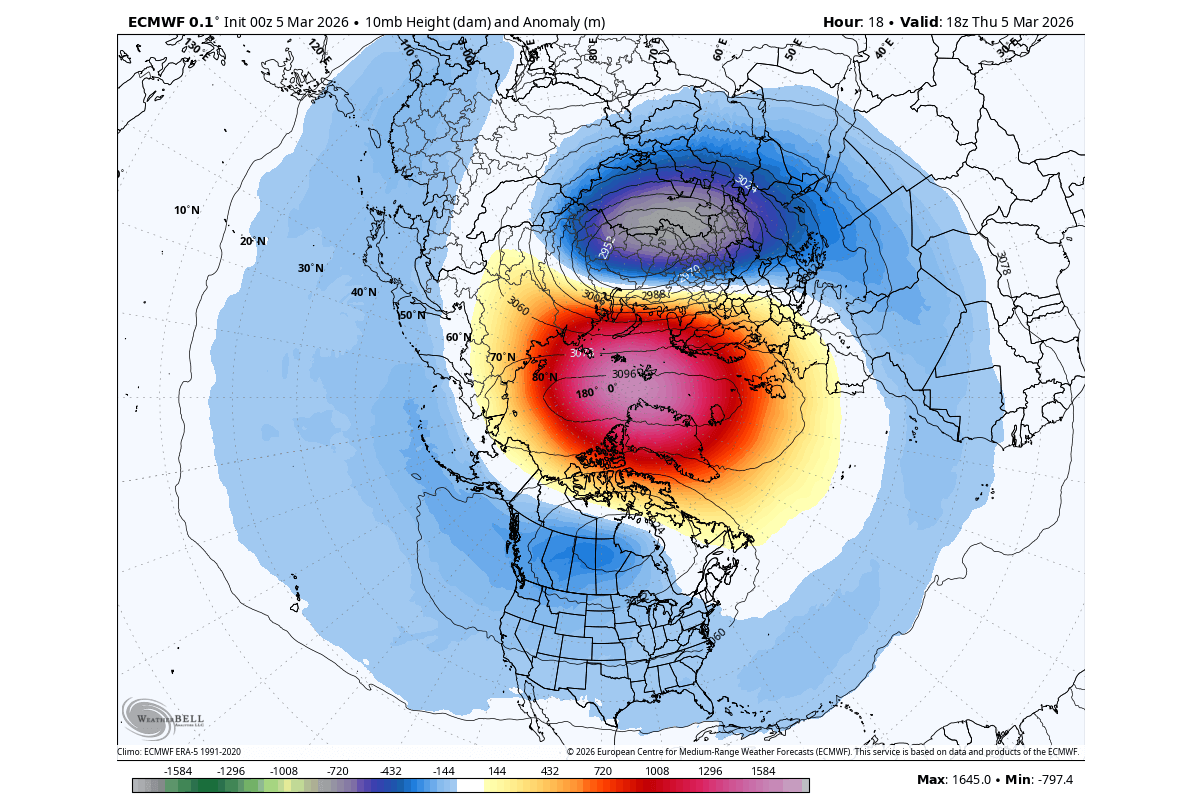
This is a rare but powerful Polar Vortex split event type, which usually has a stronger or faster downward impact on the lower levels. The limiting issue here is that the event unfolded in March, which can usually limit the cold air it can release. But this is a great recent example of a proper Sudden Stratospheric Warming (SSW) event.
Below is another example, but for a displacement event in February 2023. You can see a large warming wave in the mid-stratosphere, spread over the polar regions, along with a stratospheric high (H) covering the North Pacific and western Arctic. This high-pressure wave has displaced the Polar Vortex (L) southward and reversed the stratospheric winds.
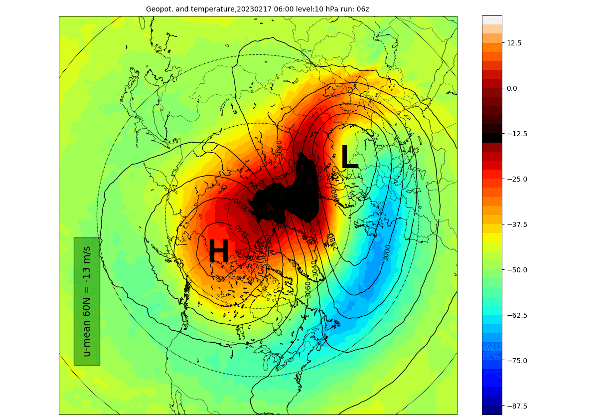
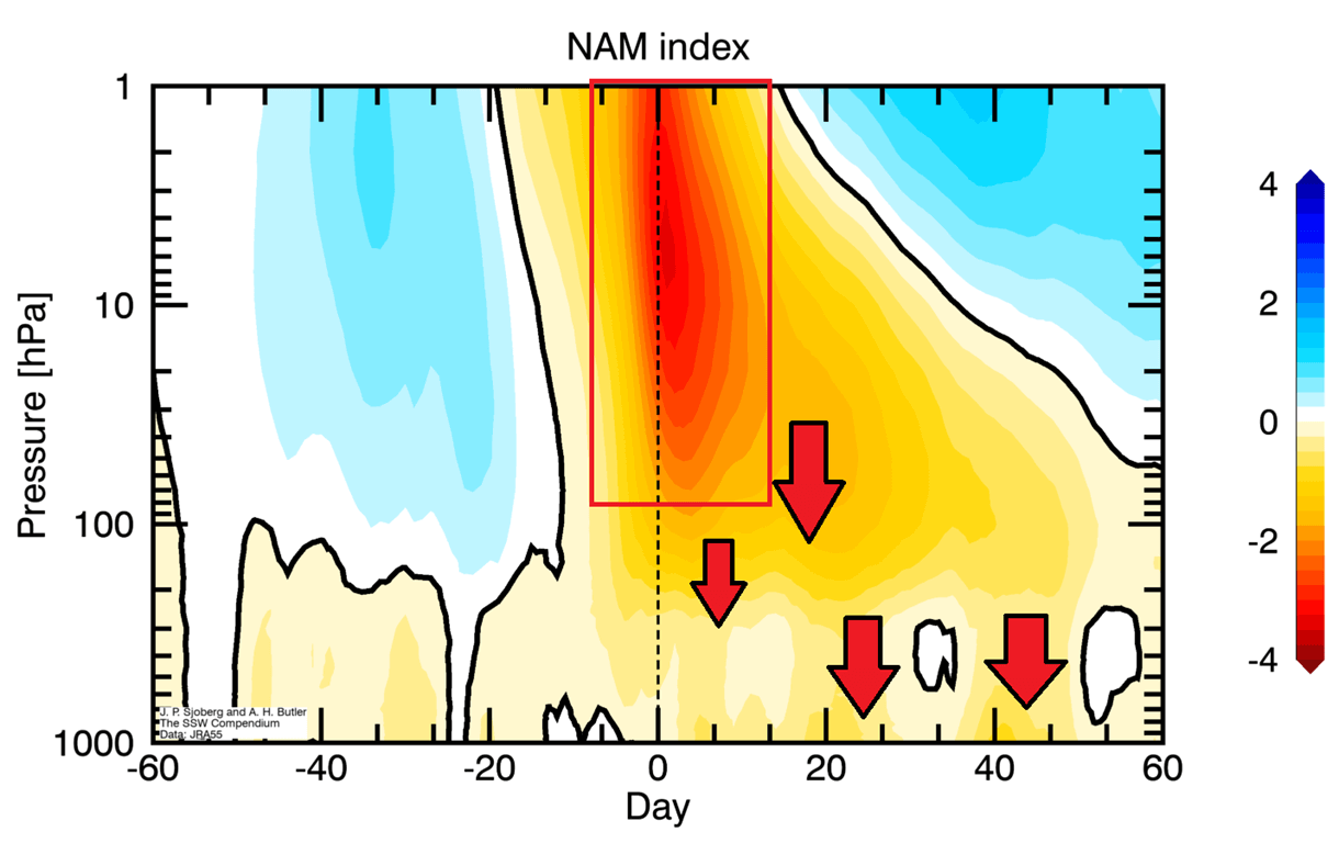
Displacement SSW events can have a slower or less immediate surface impact, while split events often produce an earlier and sometimes more persistent impact. In reality, an SSW response can vary greatly from event to event, depending on existing weather patterns. But how does an SSW event work?
The image shows pressure anomalies across the atmosphere before/after an SSW event, with 0 being the peak day of the event, or the start of wind reversal. You can see how the main event in the stratosphere sends a high-pressure wave downwards, impacting the surface with some delay, usually in the 10-30 day range. Image by NOAA CSL.
A lot happens at the surface after the SSW event. Below is the average temperature 0-30 days after a full Polar Vortex collapse, with combined data from 34 major SSW events. This shows that most of the United States and northern and central Europe are typically colder than normal after a proper Stratospheric Warming event.
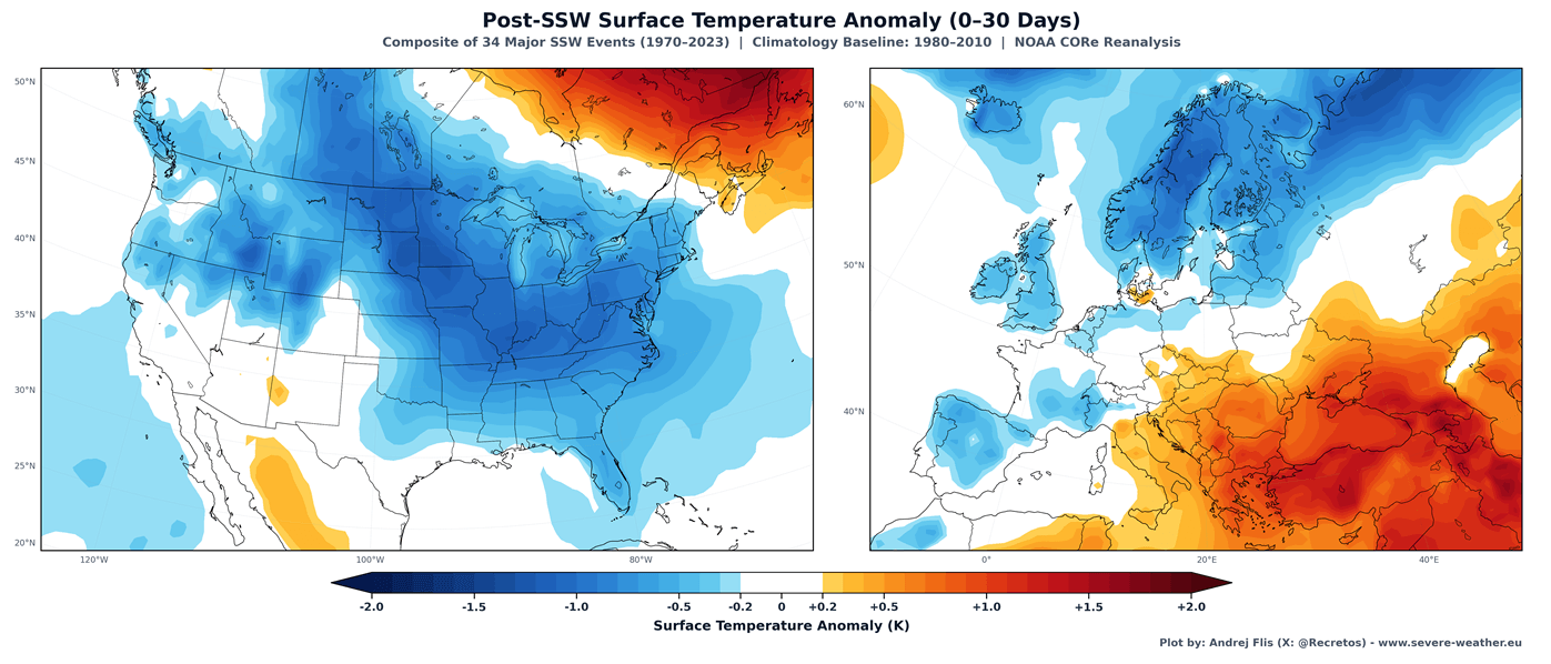
Of course, not every SSW event is exactly the same, and some events tend to cool only North America, only Europe, or only some other part of the Northern Hemisphere. A lot depends on the existing pressure patterns before an SSW strikes down from above.
But in recent seasons, we have seen Polar Vortex disruptions with a warming anomaly but without a full wind reversal or an official major SSW event designation. Yet they still impacted the weather below across the United States, Canada, and Europe.
Polar Vortex Disruptions and Cold Winter Weather
One such event was recorded at the end of January this year. You can see a disruption in the 3D analysis below: high-pressure areas with warming have compressed the Polar Vortex, elongating its structure in the stratosphere and starting a partial breakdown of the stratospheric system.
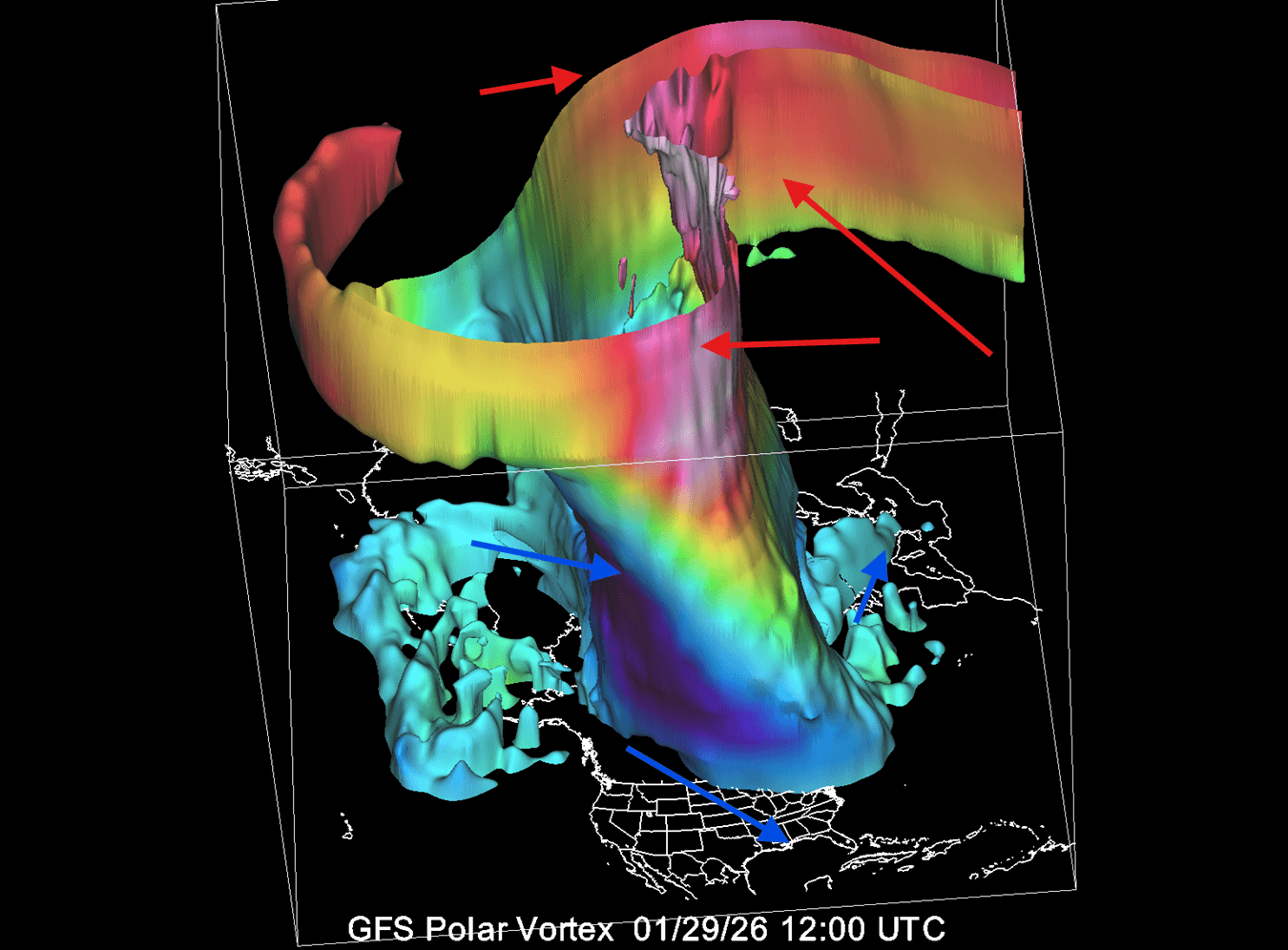
This caused the Polar Vortex to push its lower core into North America, allowing a strong northerly flow of cold air to spill into the eastern United States, Canada, and parts of Europe.
The resulting temperature anomalies from this disruption can be seen below, centered around late January and early February 2026. You can see the cold air outbreak brought down across the central and eastern United States and far southern Canada. It also affected the north-central and northern parts of Europe.
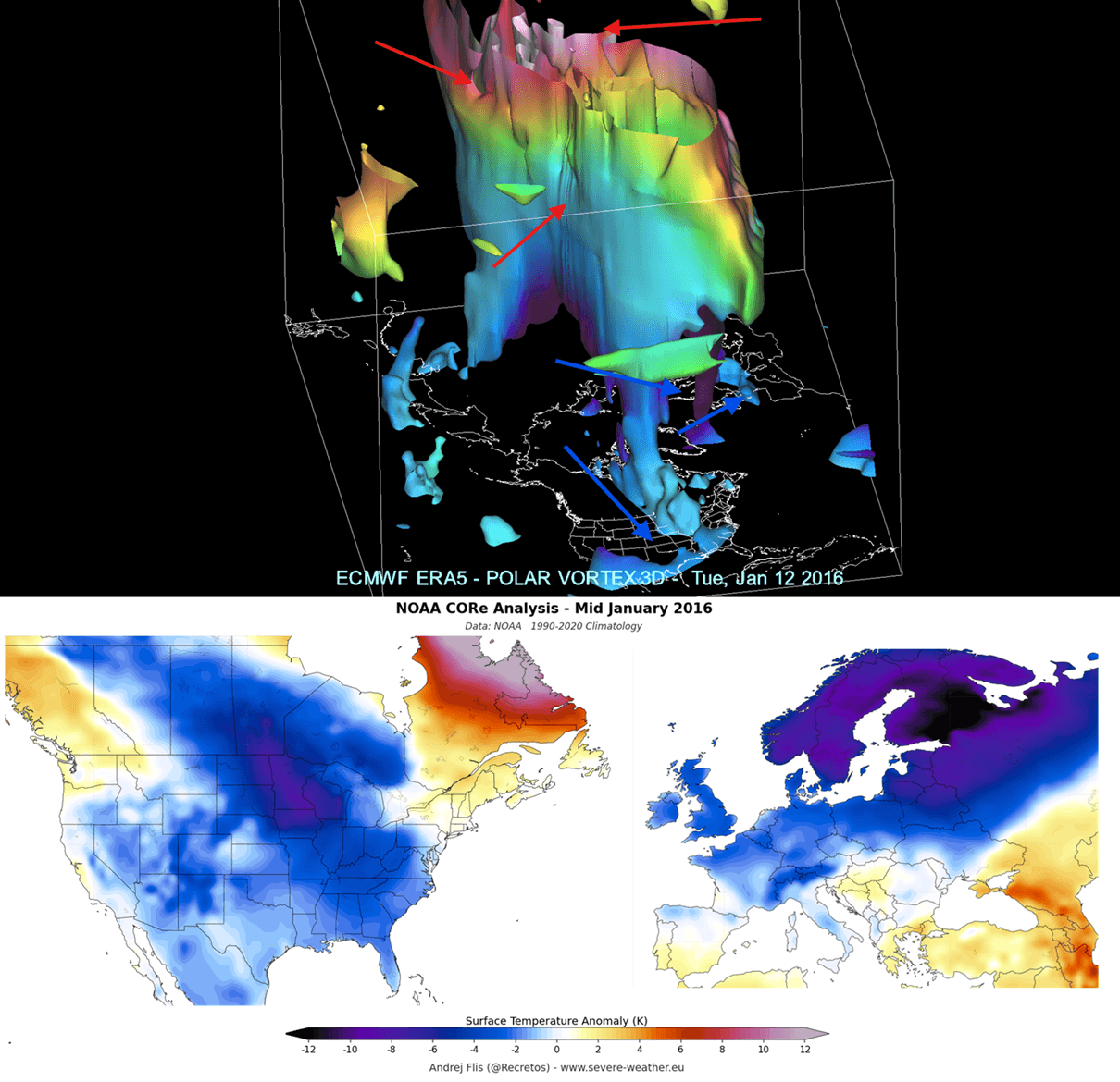
Since we are in a Super El Niño season, below is an example of such a disruption in mid-January 2016, during the last Super El Niño winter. You can see the stretched Polar Vortex with split cores in the lower levels. Pushed into mid-latitudes, these brought a cold outbreak to the United States, Canada, and Europe.
Another very similar event occurred just last December. It also featured a Polar Vortex split in the lower levels and a structure disruption, but no full collapse or wind reversal. It still brought one Polar Vortex core into North America, establishing the “Polar Express” pattern, similar to what we see 0-30 days after a proper SSW event.
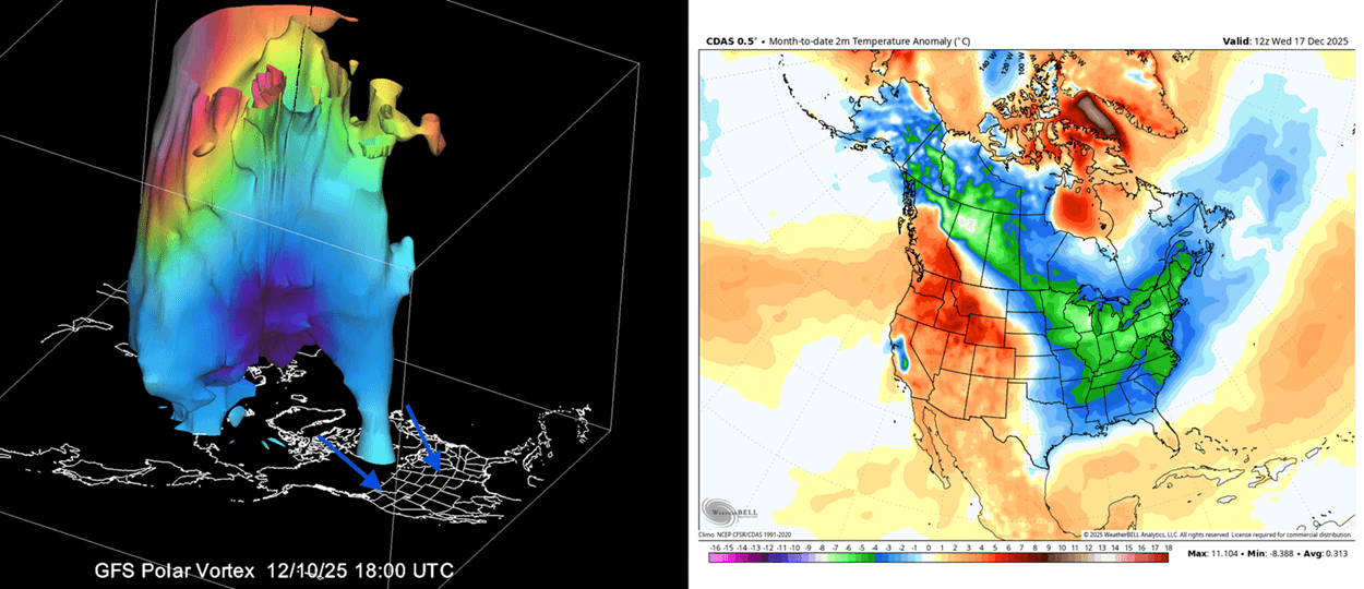
As you can see, even just a disrupted Polar Vortex can significantly change Winter weather across the United States, Canada, and Europe. For this reason, we closely monitor weather patterns and all activity surrounding the Polar Vortex, starting early, to spot the first signals of interest.
With signs emerging for a weaker Polar Vortex in 2026/2027, we will closely monitor all available data as we go forward. If the long-range trends hold, such events can strongly increase the chance for more cold winter days and snowfall over the United States, Canada, and parts of Europe.
Scientific Research Used in this Article
- ENSO–Stratosphere Pathway: Nonlinearity and Asymmetry of the ENSO Stratospheric Pathway to North Atlantic – Manzini et al. (2024).
- Polar Vortex and North American Winter Extremes: Unprecedented North American Snowstorm and East Asian Cold Wave in January 2016: Critical Role of the Arctic Atmospheric Circulation – Si et al. (2021).
Some of the images in this article are also provided by ECMWF, Weatheriscool, and WeatherBell (using a commercial license).
Don’t miss: Winter 2026/2027 Snowfall Predictions: New Data Shows a Strong Super El Niño Snow Pattern
We will keep you updated on the global weather pattern development, so bookmark our page. Also, if you have seen this article in the Google App (Discover) feed, click the like or star button there to see more of our forecasts and our latest articles on weather and nature in general.