Meteorological Spring has now begun with March. But the weather patterns over the Northern Hemisphere are not yet ready for the transition from Winter, with the polar circulation now being impacted by the breakdown of the Polar Vortex.
There are some very strong weather drivers behind these changes, that typically command the weather patterns each winter season and extending into early Spring.
We will look at what is causing these large-scale changes, and how they will play out this month and into the rest of the Spring season.
We always tend to explain the behind-the-scenes processes at work, so you can much easily understand the grand scale of weather and the bigger picture.
WINTER SEASON 2021/2022 ENDS
The meteorological winter season covers the December-January-February period, so meteorological winter officially ended with February.
At this time, we usually take a look at the first (preliminary) temperature anomaly and the pressure pattern analysis for the entire Winter season.
Below we have the Dec-Jan-Feb global pressure pattern. What stands out is the strong semi-permanent high-pressure system in the North Pacific. Also, as a response to that, we have a broad low-pressure area over Canada, covering also the northern United States and Alaska.
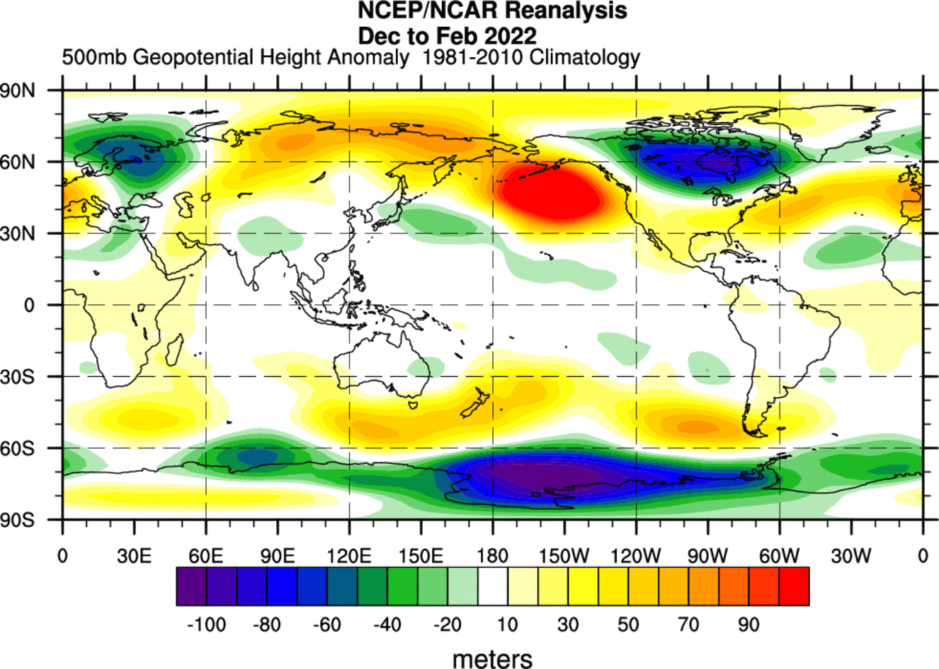
Such a pattern typically pushes the jet stream down into the northwestern United States and onward towards eastern Canada. That helped to bring colder weather to the northern parts of the United States, extending also into the eastern parts.
Over Europe, we have a ridge present over western Europe up into the North Atlantic. That means a low-pressure area is to the east of the ridge, over Scandinavia and also parts of northeastern Europe.
For the first time, we are now also going to compare this analysis to the winter forecasts from November, which is the last month before meteorological winter begins.
We can see a very good forecast from ECMWF over North Pacific and North America. There was a strong high-pressure system in the Pacific and the low-pressure zone over Canada.

The forecast was not as good over Europe, with a low-pressure zone over the North Atlantic instead of Scandinavia.
Looking at temperatures, below we have global temperature anomaly for the same period. We can actually see a lot of warm anomalies in the polar regions, north of the 60N latitude. What stands out is a large and strong cold pool over Canada.
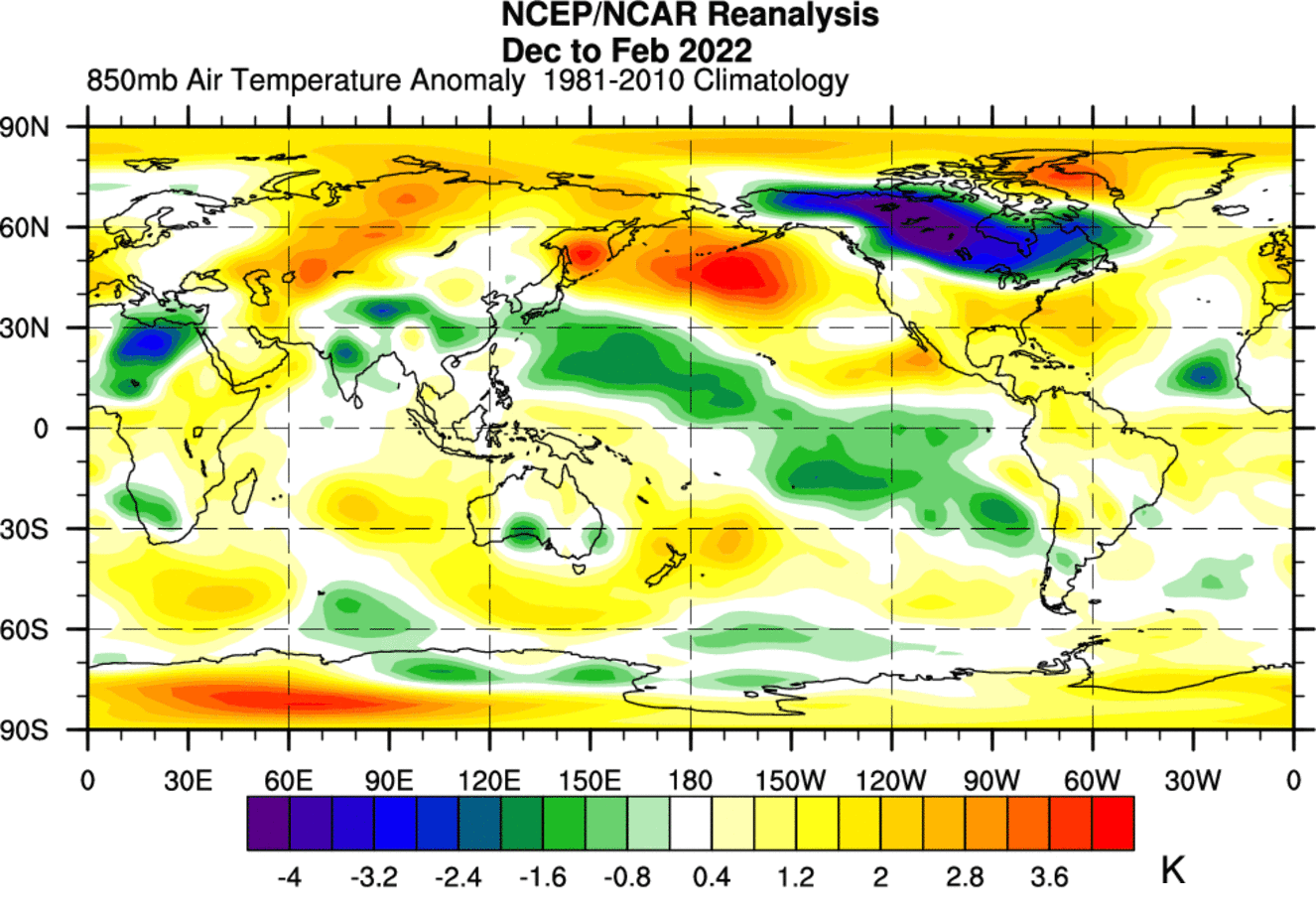
Most of Europe and the United States are under warmer than normal conditions. But the second half of the winter season has featured cold air outbreaks into the eastern half of the United States. In Europe, there were not enough cold air outbreaks to change the warmer average into negative anomalies.
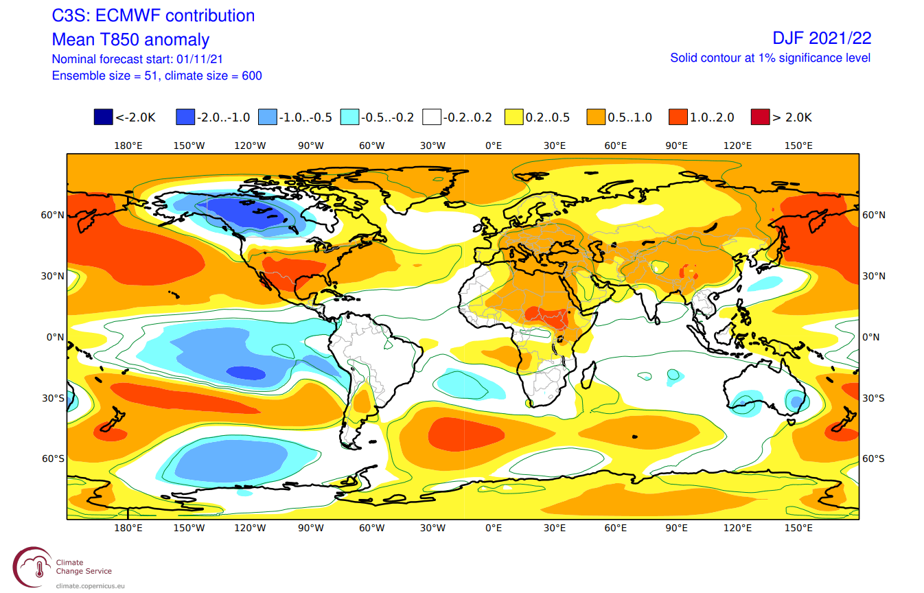
Now looking at the ECMWF global temperature forecast issued in November, we can see the strong cold pool over Canada, and warm anomalies over much of the United States.
In reality, the warm anomalies over the United States were not as strong, and the central and eastern states have seen quite a few cold air outbreaks in the second half of winter.
Over Europe the forecast was not completely off, just the main bulk of warmer anomalies was further over western and central Europe.
LARGE-SCALE WEATHER DRIVERS
When we look at the seasonal forecasts for winter (or any other season) we always look at the large-scale climate drivers first. This season, it was the La Nina in the tropical Pacific Ocean.
But once the season starts, we tend to look more closely at the short-term variability. Besides the La Nina which we will cover later below, we have one other driver of the weather in the Northern Hemisphere. The infamous Polar Vortex.
NORTH HEMISPHERIC POLAR VORTEX
Every year as we head into autumn, the polar regions receive less and less sunlight. This way, cooling begins over the north pole.
But as the polar temperatures drop, the atmosphere further south is still relatively warm as it continues to receive energy from the Sun.
You can see the winter solstice in the image below. The polar regions receive little to zero solar energy, compared to regions further south, which still continue to receive plenty of sunlight and energy.
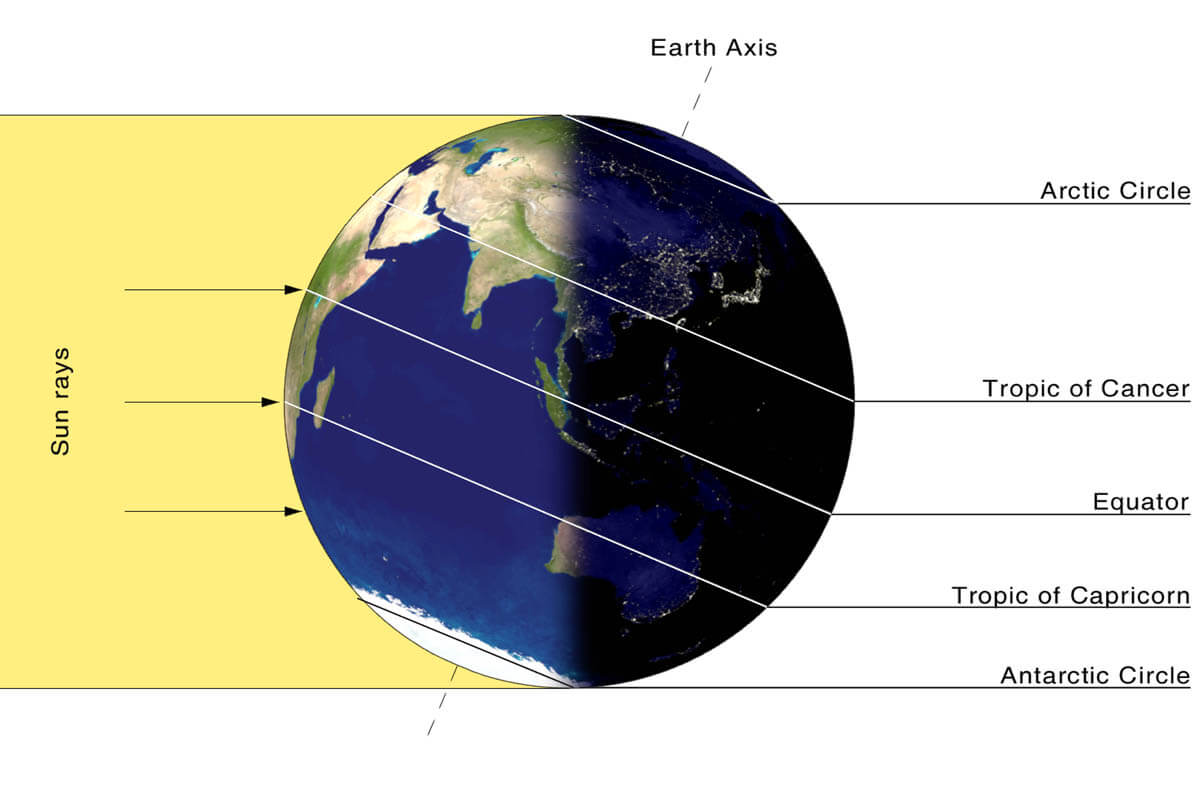
But, as the temperature begins to drop over the polar regions, so does the pressure. With colder temperatures over the pole, the temperature difference towards the south increases.
This also causes a pressure difference as a large low-pressure (cyclonic) circulation starts to develop across the Northern Hemisphere. It extends from the surface layers, far up into the stratosphere. This is known as the Polar Vortex.
The image below shows a typical example of the Polar Vortex at around 30km/18.5miles altitude (10mb level) around the middle stratosphere during the winter season.

It is basically like a very large cyclone, covering the whole north pole, down to the mid-latitudes. It has a strong presence at all levels, from the ground up, but can have different shapes at different altitudes.
In the next image below, we have the polar vortex at a much lower altitude, around 5km/3miles. The closer to the ground we go, the more deformed the polar vortex gets because it has to interact with the mountains and overall terrain and also with the strong weather systems

Be aware of its “arms” extending into the lower latitudes, bringing along colder air and snowfall. These arms also pack a lot of energy and can create strong winter storms, either Noreasters in the United States or powerful wind storms in the North Atlantic.
We are typically focusing more on the Stratospheric Polar Vortex, as it plays a very important role in the weather development throughout the season. It is known for its strong influence down from the stratosphere, in either direction, for a cold or warm winter.
A strong Polar Vortex usually means strong polar circulation. This usually locks the colder air into the Polar regions, creating milder weather for most of the United States and Europe.
As a contrast, a weak (wavy) Polar Vortex can create very dynamic weather. It has a much harder time containing the cold air, which can now escape out of the polar regions, into the United States and/or Europe. Image by NOAA.

Typically, a polar vortex circulation is disrupted due to a rise in temperature in pressure in the stratosphere. That is called a Sudden Stratospheric Warming (SSW) event.
But there can also be smaller warming waves in the stratosphere, that do not collapse the polar vortex. Instead, they can sometimes displace or disrupt the polar vortex enough to weaken its influence on the surface levels. That can allow other drivers to take over more strongly, creating a different weather pattern.
To put the Polar Vortex into a perspective, we produced a high-resolution video, which nicely shows the vortex spinning over the Northern Hemisphere in the stratosphere at the 30mb level, around 23km/14miles altitude.
Video shows the NASA GEOS-5 analysis for late January 2022. Notice how the stratospheric vortex covers a large part of the Northern Hemisphere. It spins over the Northern Hemisphere, driving also the winter weather below with its circulation.
The main takeaway from the video should be that the Polar Vortex is not just one single winter storm or a cold outbreak that moves from the Midwest into the northeastern United States.
It is one large cyclonic area that is spinning over the entire Northern Hemisphere, from the ground up to the top of the stratosphere and beyond, reaching over 50km/31miles in altitude.
The Polar Vortex is important to monitor because every disruption as either a warming or a pressure wave in the stratosphere can mean a change in weather dynamics below.
The next image below shows pressure anomalies from the surface into the upper stratosphere over the winter season.
You can observe the strong low-pressure buildup in the stratosphere in late November. That was a strong polar vortex, connecting down to the surface levels in early December.
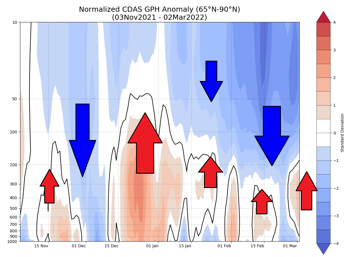
But strong high-pressure anomalies have emerged over the polar circle in December, which pushed back against the stratosphere, “disconnecting” the upper and the lower polar vortex far into February.
As far as the stratosphere and weather connection goes, there is a special graphic that puts that into a simple perspective. We can look at the pressure development from the surface up into the stratosphere over time.
The next image shows also shows the forecast, where we can see strong high-pressure systems in the lower levels which are pushing up against the polar vortex in March.
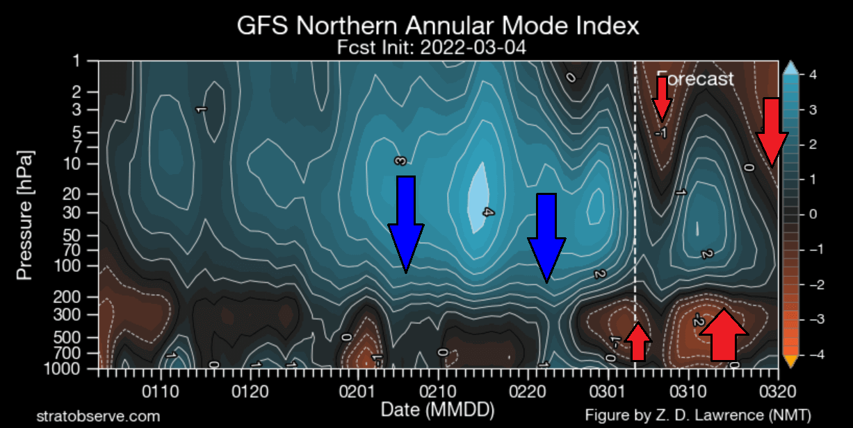
There are also high-pressure systems pressing down on the polar vortex from the very top of the stratosphere. All combined, it is slowly breaking down the polar circulation in the stratosphere, also impacting the weather patterns ahead.
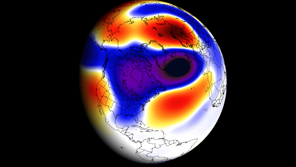
Below we have a 3D structure image of the Polar Vortex. It shows the Polar Vortex being split apart into two separate cores. This is a major development, that will impact the polar circulation. You will find out in the forecast how this happened and what it means for the weather.

But the large-scale culprit behind the low-level blocking and weather dynamics this season was/is the oceanic La Nina. We mentioned it before, and we will quickly look at its current state and its role in the Spring weather ahead.
ENSO AND ITS COLD LA NINA
ENSO is short for “El Niño Southern Oscillation”. This is a region of the tropical Pacific ocean, changing between warm and cold phases on the ocean surface (and in-depth). Typically there is a phase change in around 1-3 years.
ENSO has a major influence on the tropical rainfall patterns (storms) and the complex exchange between the ocean and the atmosphere. Large-scale pressure changes can be observed in the tropics with each new developing phase. With some delay, these changes affect the circulation over the rest of the world.
The cold ENSO phase is called La Nina and the warm phase is called El Nino. Besides the temperatures, one of the main differences between the phases is also in the pressure state.
On the image below you can see the ocean surface temperature and pressure pattern difference between the warm and the cold phase.
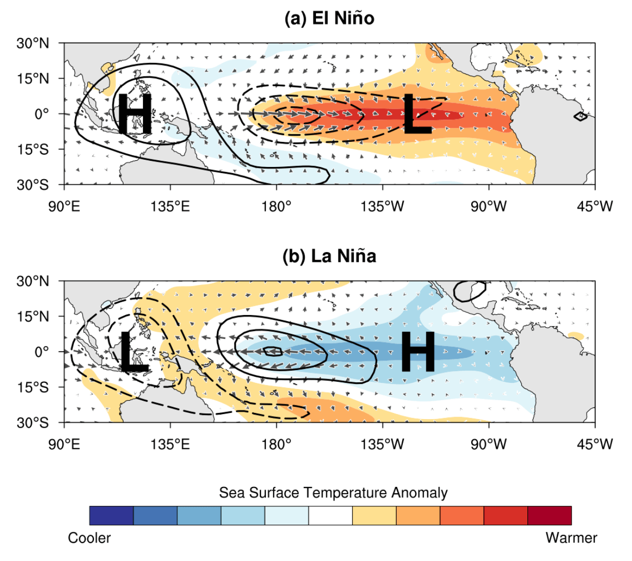
During an El Nino, the pressure over the tropical Pacific is lower, with more rainfall and storms.
But during a La Nina, the pressure over the equatorial Pacific is high, creating stable conditions and less precipitation. This obviously translates into the global circulation, affecting both the Northern and the Southern hemispheres.
Below we have the latest global ocean temperature anomaly analysis from NOAA. We can clearly see the decaying cold anomalies in the tropical Pacific Ocean. That is the current La Nina phase slowly weakening, but still maintaining the cold anomalies within the La Nina threshold.

Combining the strongest 13 cold ENSO events gives us an idea of what their main weather influence is. The main feature, as you can see, is a high-pressure system in the North Pacific and low pressure over Canada.

This is what we have seen in the winter analysis at the beginning of the article. It helps us to confirm the strong presence and influence of the oceanic anomaly.
Over Europe, we see lower pressure over Scandinavia and higher pressure over northwestern Europe, but that cannot be designated as a typical weather response from the La Nina, due to low signal strength.
Knowing what will drive our weather in the coming weeks, we will look at the latest forecasts and how the weather will evolve this month.
POLAR VORTEX BREAKING DOWN
The strength of the polar vortex is most often measured by the power of the winds that it produces. This is done by measuring the zonal (west to east) wind speeds around the polar circle (60°N latitude).
On the image below we have the seasonal average wind speed for the Polar Vortex at 10mb level. The black line is the long-term average, and the blue line is the polar vortex strength in the 2021/22 season.
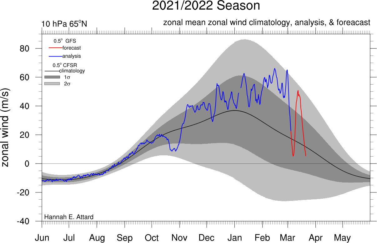
But the red line is actually the forecast, which shows the rapid weakening of the polar vortex is now starting and will continue into the month of March.
Below we have a closer look at the extended ensemble forecast for the 10mb winds. It shows the polar vortex currently weakening and then powering back up again briefly.
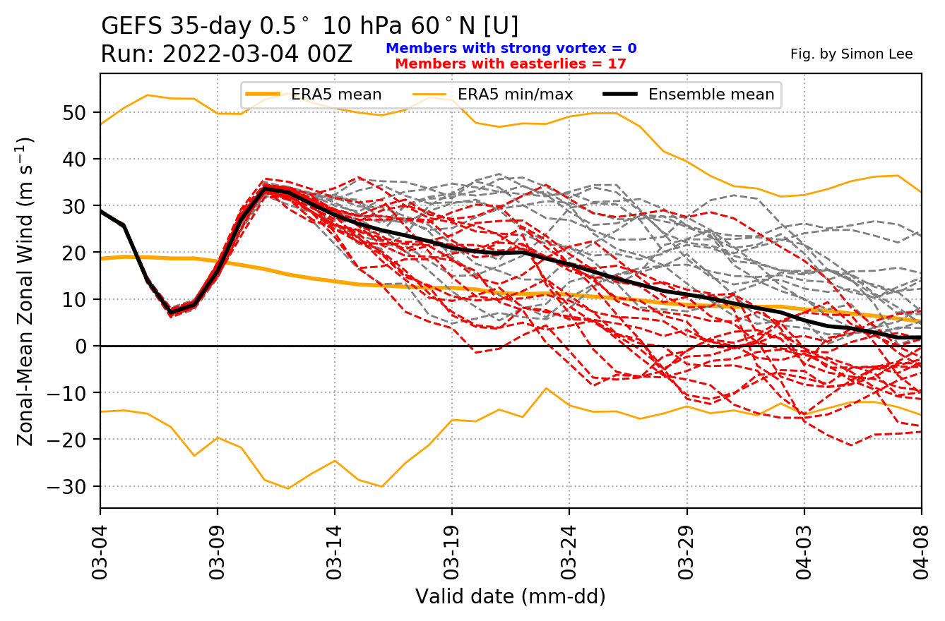
But after the brief power-up, the polar vortex will be under too much pressure. It will slowly weaken and break down, heading going into April.
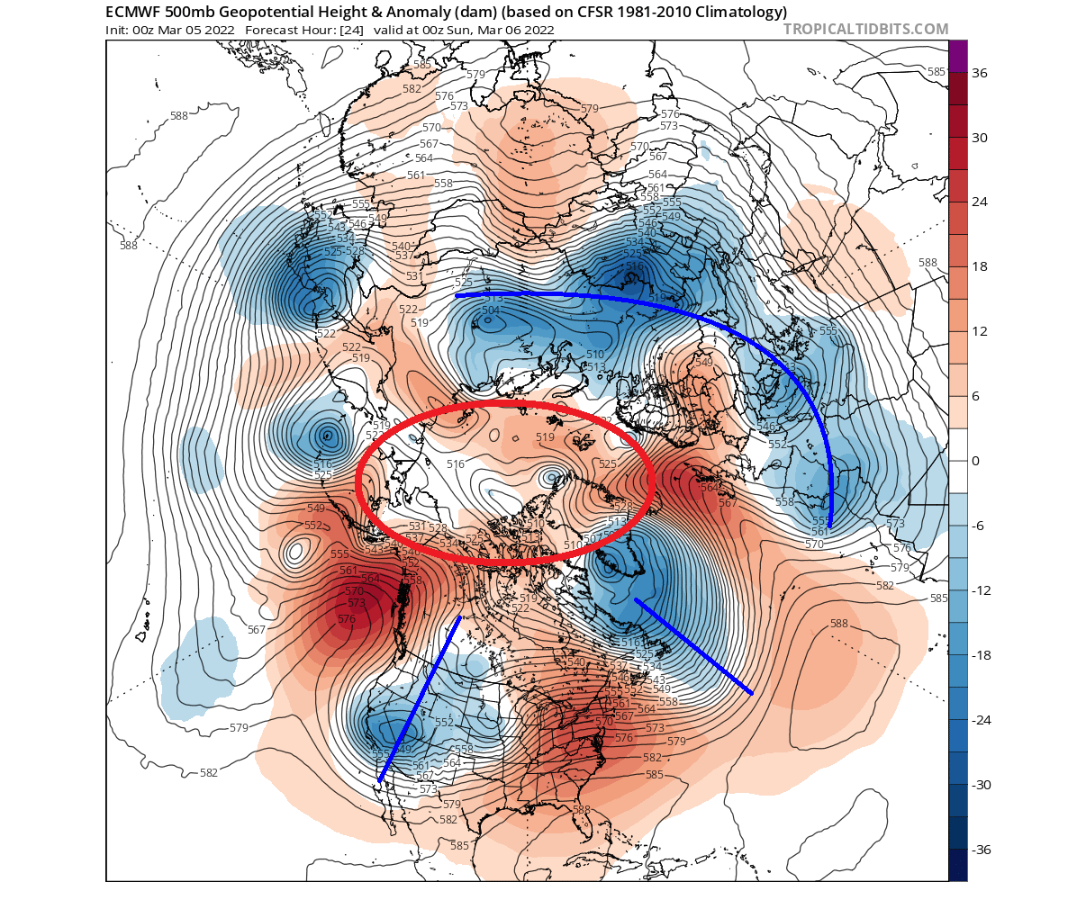
Looking at the current polar vortex development, we can see that the vortex is under heavy pressure from the North Pacific and the Atlantic sector. It has been broken/split into two separate cores, one over east Canada and one over Siberia.
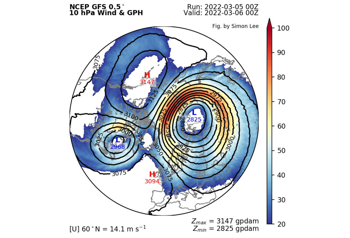
Taking a look at temperatures on the 10mb level (30km/18.5mi), we can see a warming wave engulfing both cores. A weak cold-core remains over Europe. These two low-pressure cores are what we have seen earlier above on the 3D structure.

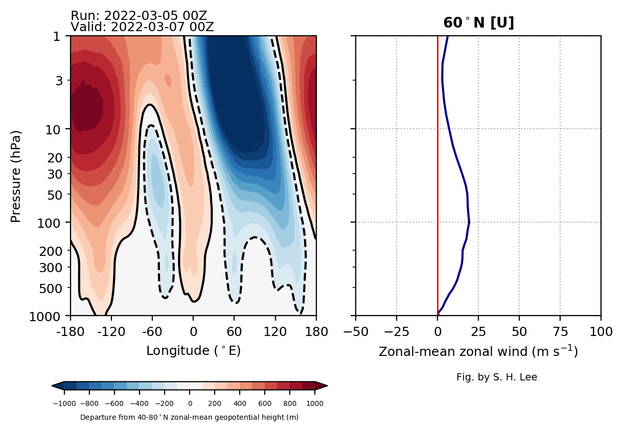
Next up, we have the vertical pressure anomaly profile, revealing a connection between the stratosphere and the lower levels.
We can see the two cores of the split polar vortex. Both are connected down to the lower levels, directly to the weather systems over Canada and one over Eurasia.
This is a unique pattern setting up, called a negative Arctic Oscillation (AO). This is a weather oscillation that describes the atmospheric pressure and circulation around the Arctic circle. Negative AO equals a weak polar vortex and positive AO responds to a strong polar vortex.
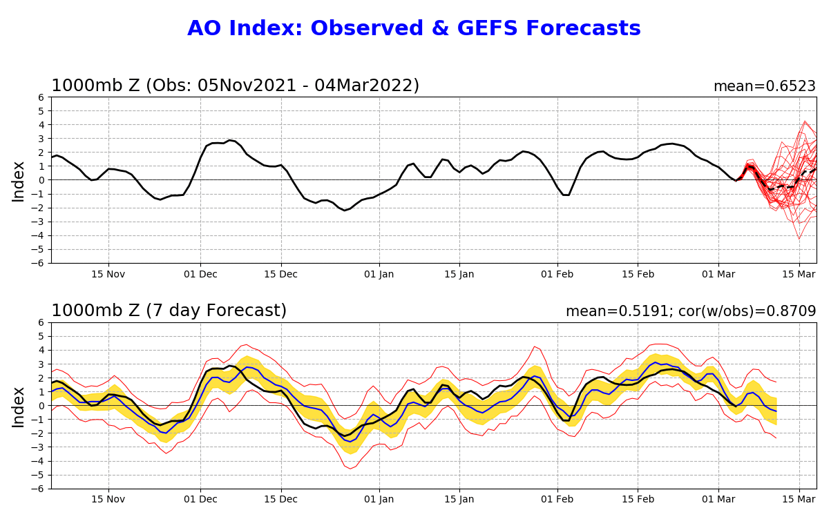
We can nicely see that if we look at the latest state of pressure anomalies across the Northern Hemisphere. The Polar regions are dominated and surrounded by high-pressure anomalies.
Low-pressure systems and colder air is being displaced out of the polar regions, with one lobe over Eurasia and one pair over Greenland and the western United States. Such a pattern can be called “March madness”.
First looking at Europe, we can see the latest conditions being quite colder than normal over much of the continent. The exception is far northern Europe, currently under the influence of a ridge.

Taking a closer look at North America, we see mostly warm anomalies over much of the eastern half United States and Canada. Colder than normal weather is ongoing over most of the western half of the United States.

POLAR CIRCULATION SLOWS
Going further into the mid-month, the polar vortex will make a brief recovery, as the high-pressure systems pull back. We can see the stronger core moving back over the polar regions. The smaller core has faded out. Despite recovering, it is not strong enough to also stabilize the lower level weather circulation.

In the lower levels, we will be witnessing a similar pattern as we have seen before in the stratosphere, which is of course a broken down circulation. We have two main low-pressure zones, one over the Siberian region and one of course over North America.

Here the polar circulation is also “split” apart like in the stratosphere. It is disrupted by the strong high-pressure systems crawling over the Arctic, changing the jet stream and the path of weather systems.
Over Europe, colder weather will prevail in this period. Warmer than normal temperatures will expand over northern Europe, as the strong high-pressure ridge moves into Scandinavia. But that also amplifies the cold air transport from the north/northeast.

Over North America, we can see a strong pattern shift. As one core of the lower polar vortex stabilizes over Canada, it establishes a cold air transport from the north. A cold outbreak is expected in this period, affecting most of the United States to a varying degree.

Looking more closely, the main deterministic weather model shows an example of how this strong cold air outbreak will quickly spread from western Canada into the northwestern United States and down into most of the country. This is a significant cold anomaly for this time of the year.
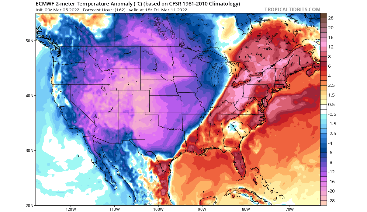
The far eastern half of the United States is expected to have quite warmer than normal weather, in the warm southern flow ahead of the approaching cold outbreak.
SECOND HALF OF MONTH, SECOND BREAKDOWN
Taking a look at the temperature profile at the 10mb level (30km/18.5mi), we see another breaking (split) event in the second half of the month. The culprit is the same, high-pressure systems slicing the polar vortex in half.

One high-pressure system is pressing on the polar vortex from the North Atlantic, and one from the North Pacific. But a decent double temperature wave is also involved, helping to further weaken the main core of the polar vortex, which otherwise thrives on colder temperatures.
The vertical pressure anomaly profile reveals a connection in a similar place as with the first break (split) event. But this time, the two cores are more evenly matched in power, tho connecting to the lower levels in a similar region.

The pressure pattern forecast for the early parts of the second half shows the breakdown event of the polar circulation to also continue in the lower levels. We can see that the high-pressure rising over the Pole is persistent, keeping the low pressure locked over Canada and the Siberian sector.

In Europe, we see the colder air finally moving out, being confined more to western Europe. Warmer air advances further into central Europe, as the strong ridge starts to take over.
Over North America, we can see a strong cold pool remaining over Canada and the northern United States. This, together with the weakened polar circulation does allow for a drop of colder than normal air into the eastern half of the United States.
NOAA also regularly releases their 8-14 day forecast for the United States. Below we have the temperature forecast for mid-March, where NOAA calls for colder weather in much of the northern and eastern United States, with the coldest in the Midwest.
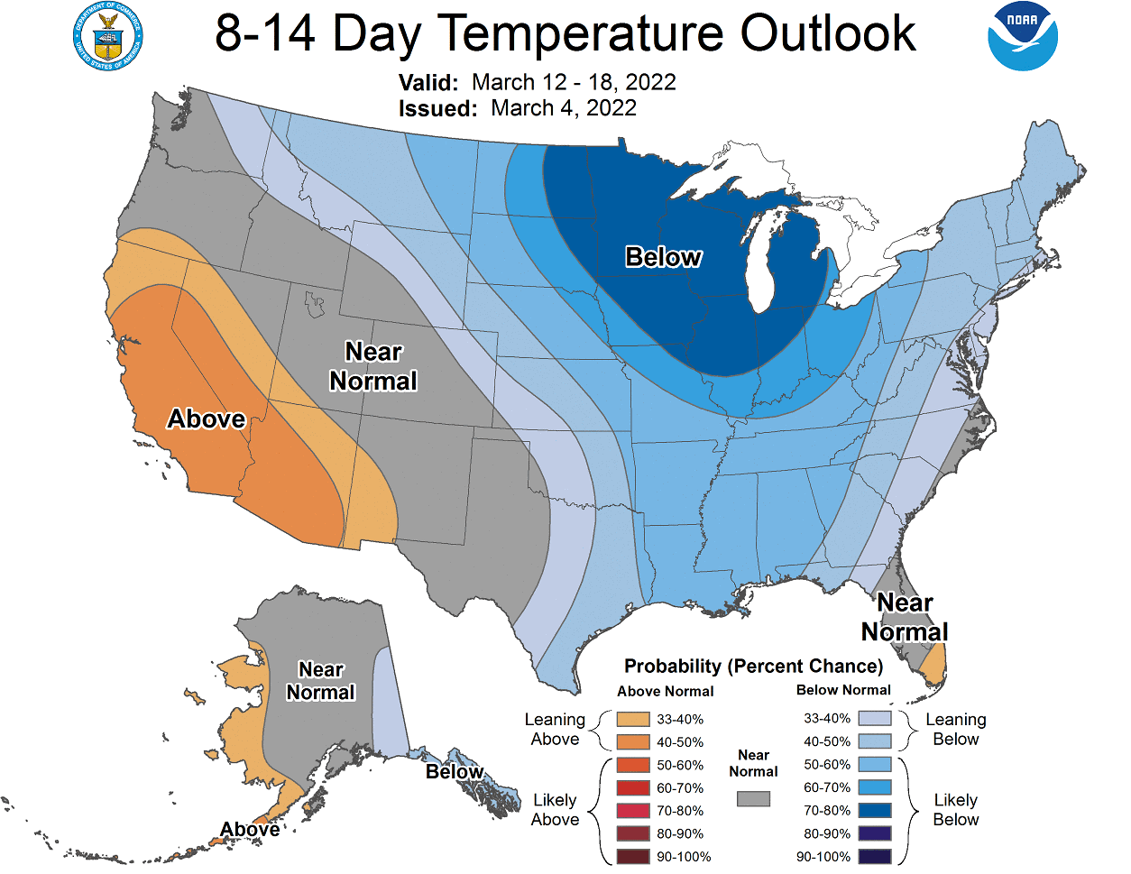
Warmer than normal weather is expected in the southwestern United States, under a high-pressure zone.
We have the precipitation forecast below, which calls for more precipitation in the northwest and in the northeast. The central and southern United States can expect drier than normal conditions in the mid-month.

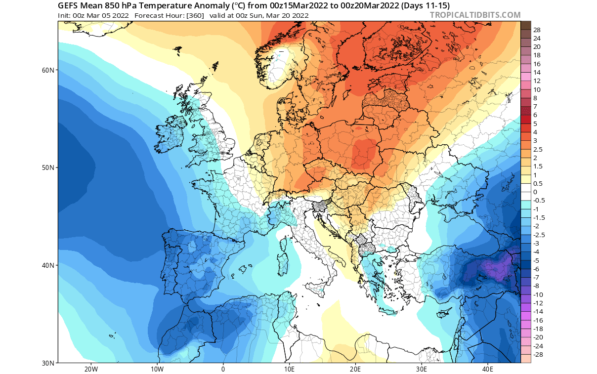
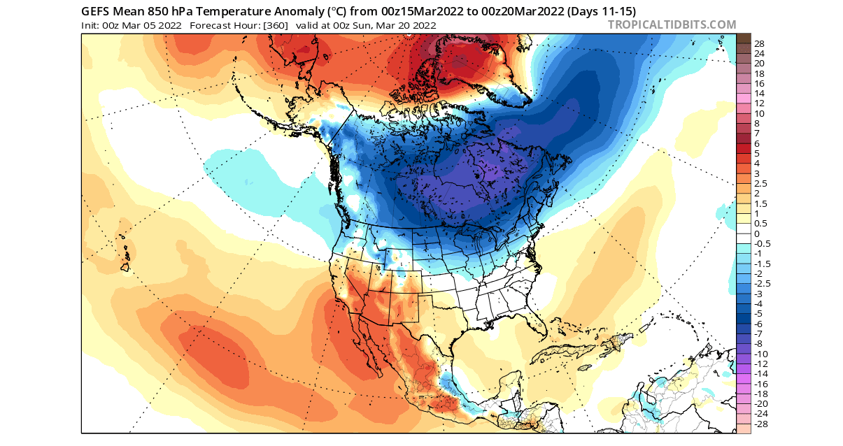
Taking a look at the far second half of the month, requires a different approach, using the extended/weekly forecast from the ECMWF extended ensemble forecast.
LATE MARCH 2022 WEATHER
Looking at the pressure pattern, we see a continuation of the weather pattern. The polar circulation is still broken down, with the main source of power being the core over Canada. A high-pressure system prevails over Europe.
The temperature forecast for Europe suggests colder temperatures in the far southeast. But most of the mainland will see a return of warmer than normal weather, under the expanding high-pressure blocking.
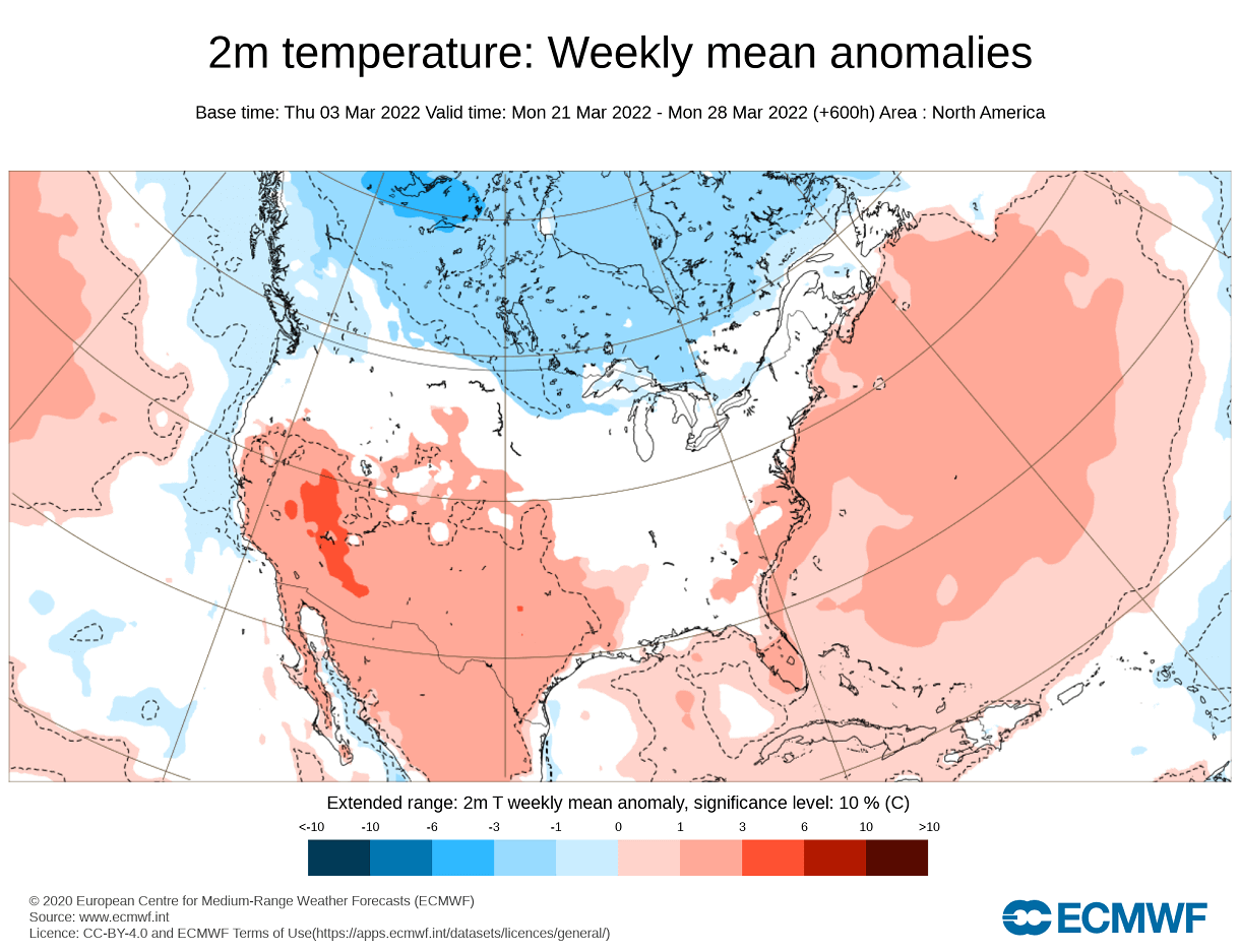
Over North America, the pattern continues from February, with a temperature gap from the northern United States down into the eastern half. This is a likely path of continued colder air outbreaks, as long as the strong cold air anomaly remains up in Canada.
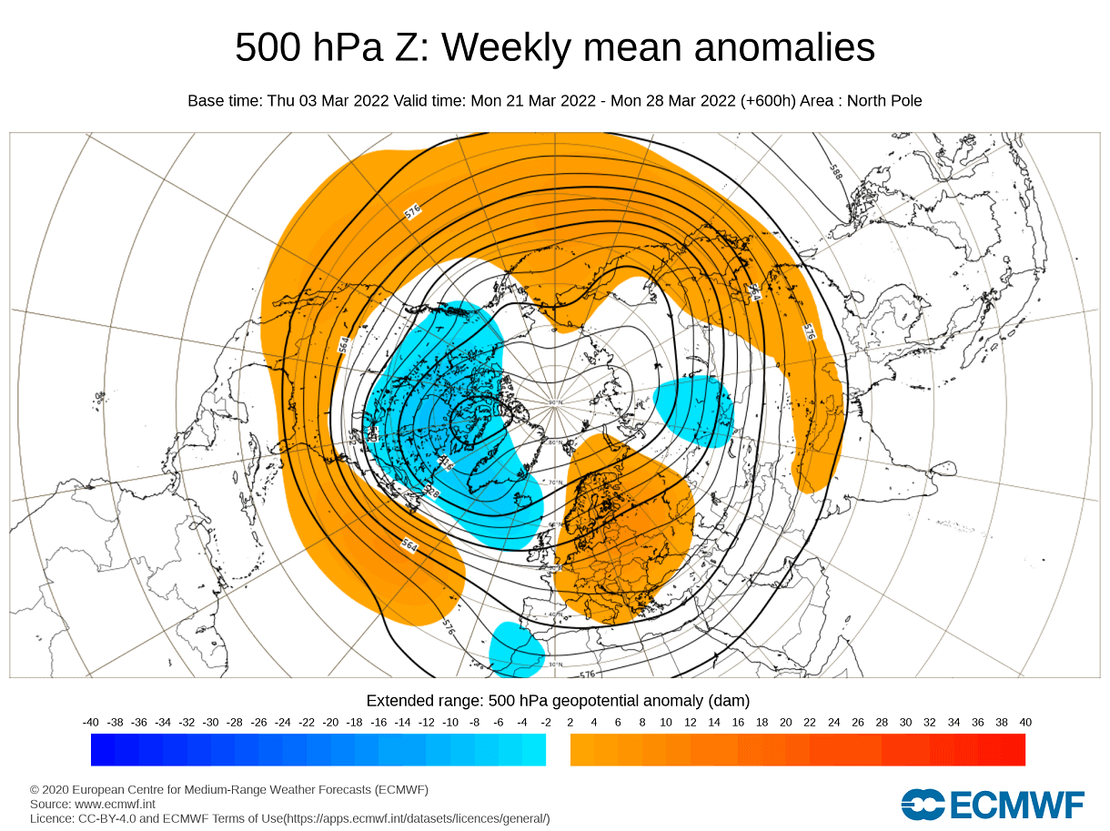
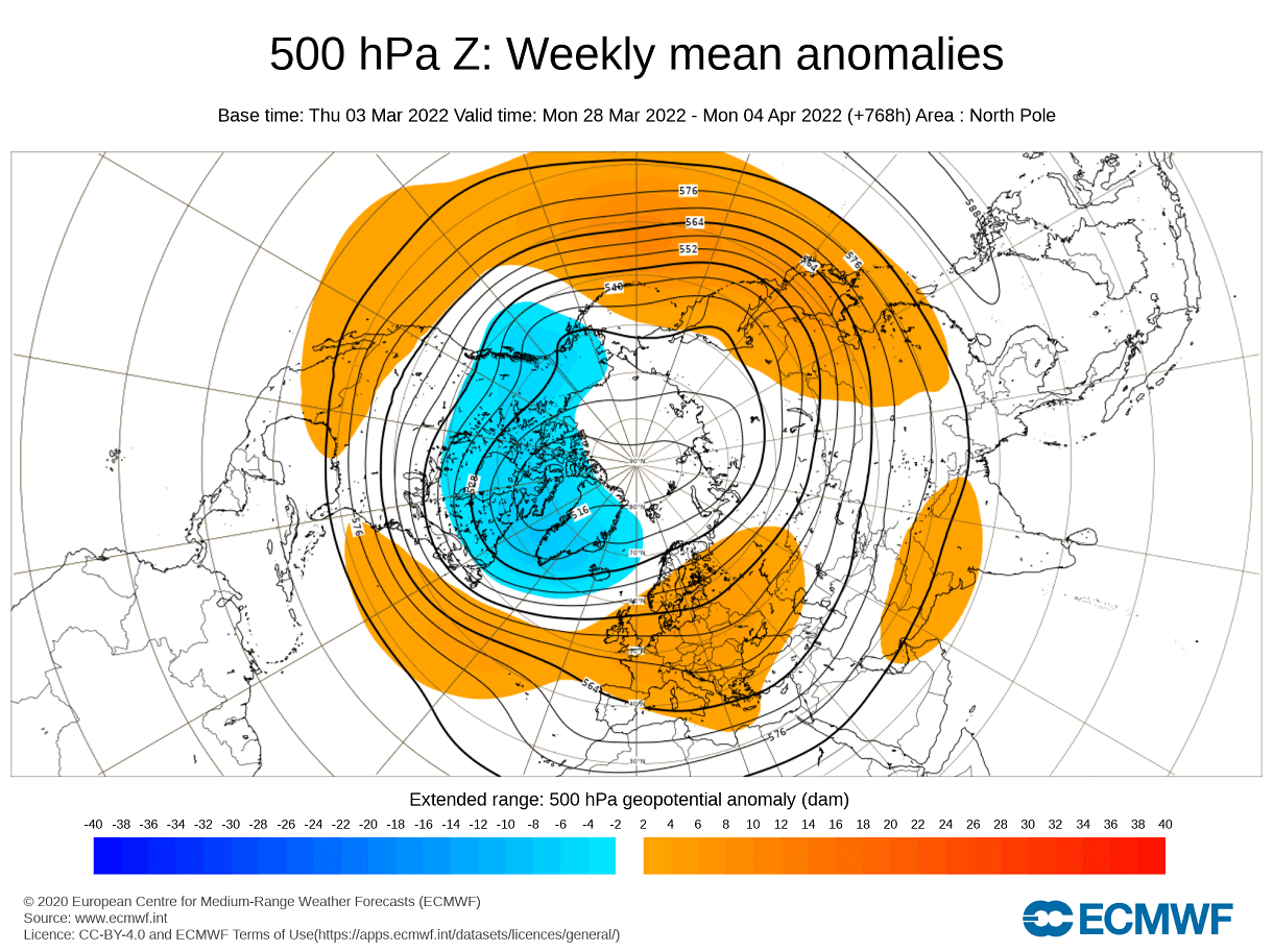
Looking at the pressure pattern going into April, we can see an attempt at a slight recovery in circulation. The strong cross-polar ridging is not really seen at present. The main low-pressure core remains over Canada and Greenland.
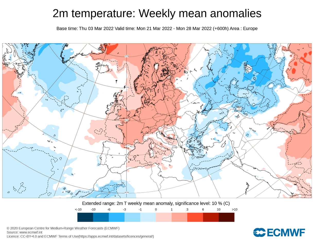
The temperature forecast for Europe suggests the same pattern as in late March, with warmer than normal temperatures taking over most of the continent.

Over North America, the pattern doesn’t change much going into the first days of April. Some of it is due to the stable low-pressure system over Canada. But it can also be due to the forecast just averaging out at this extended time range.

The fact remains that as long as there is a stable low-pressure anomaly over Canada, there will be a cold anomaly region there, allowing colder air outbreaks, which in spring can also lead to severe weather.
MARCH 2022 OFFICIAL NOAA FORECAST
Every month, NOAA also releases the monthly outlook for weather conditions across the United States.
Below is the latest official March 2022 temperature forecast/outlook for the United States by NOAA. It shows the temperature probability, with colder weather being more likely in the northwestern United States.

The southern and eastern United States have a higher probability of warmer than normal weather.
The official precipitation forecast is similar to the model forecast. We see an equal-to-higher probability for more precipitation in the northwestern and the eastern United States. The far southern United States is forecast to have a drier than normal month, especially in the southwest.

A special forecast graphic below shows the drought tendency over the month of March. We can see continued to worsen drought conditions over much of the western half of the United States.

But what are the current drought conditions? Well, most of the western and southern United States is under some level of drought conditions. The driest conditions prevail in the south-central states and in the northwestern United States.

As you will see also below on the outlook for the entire Spring season, the drought conditions in the southwestern United States will prevail for some time. And likely worsen.
SPRING 2022 SEASONAL WEATHER FORECAT
We will look at the ECMWF model, as it is often referred to as “the best” model for long-range forecasting.
In the pressure pattern forecast from ECMWF below, we can see the typical La Nina high-pressure system in the North Pacific. The low-pressure system is present over western Canada and expanding into Greenland and the polar regions.
The jet stream is bending in between the high and low-pressure systems as we have seen in the previous, as during the winter.
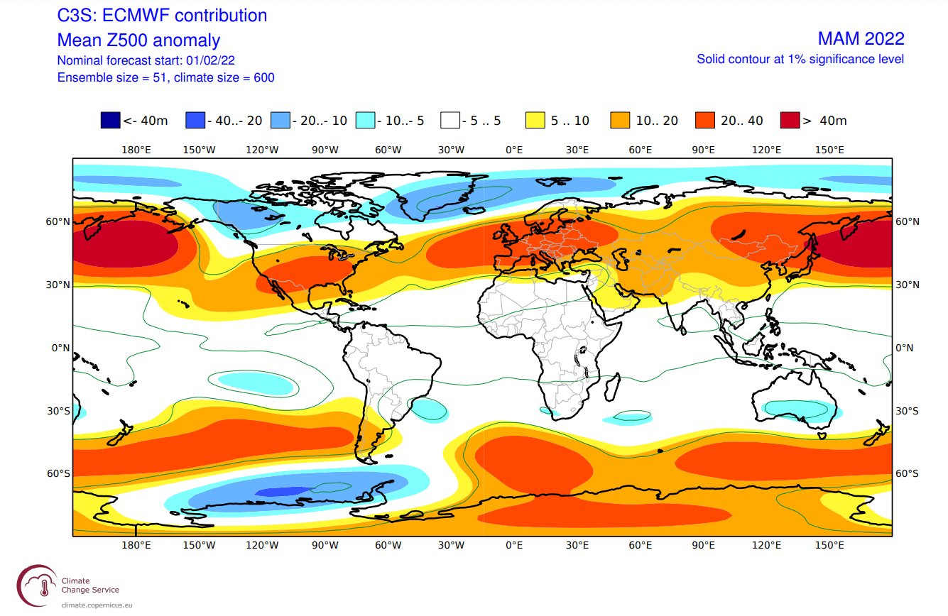
We see the North Atlantic in a positive North Atlantic Oscillation (NAO) mode, which means an amplified jet stream from Iceland and into Scandinavia. A positive NAO generally means mild/warmer conditions for Europe and the southeastern United States.
The global temperature forecast below shows North America divided into two parts. Western Canada is forecast to remain colder than normal, thanks to the jet stream position. There is a high chance of this colder air extending south, into the parts of the northern and eastern United States. The Southern United States is forecast to be warmer than normal.
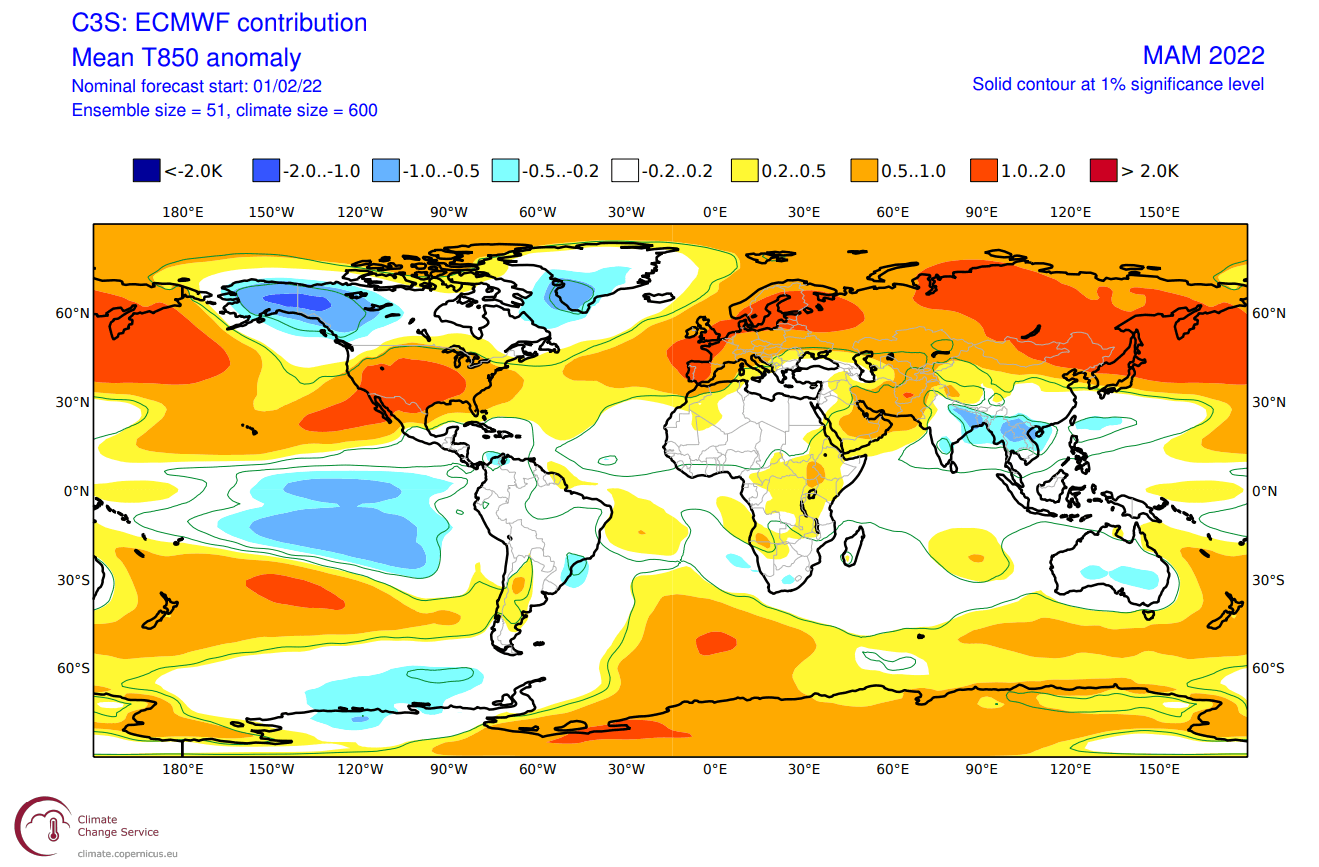
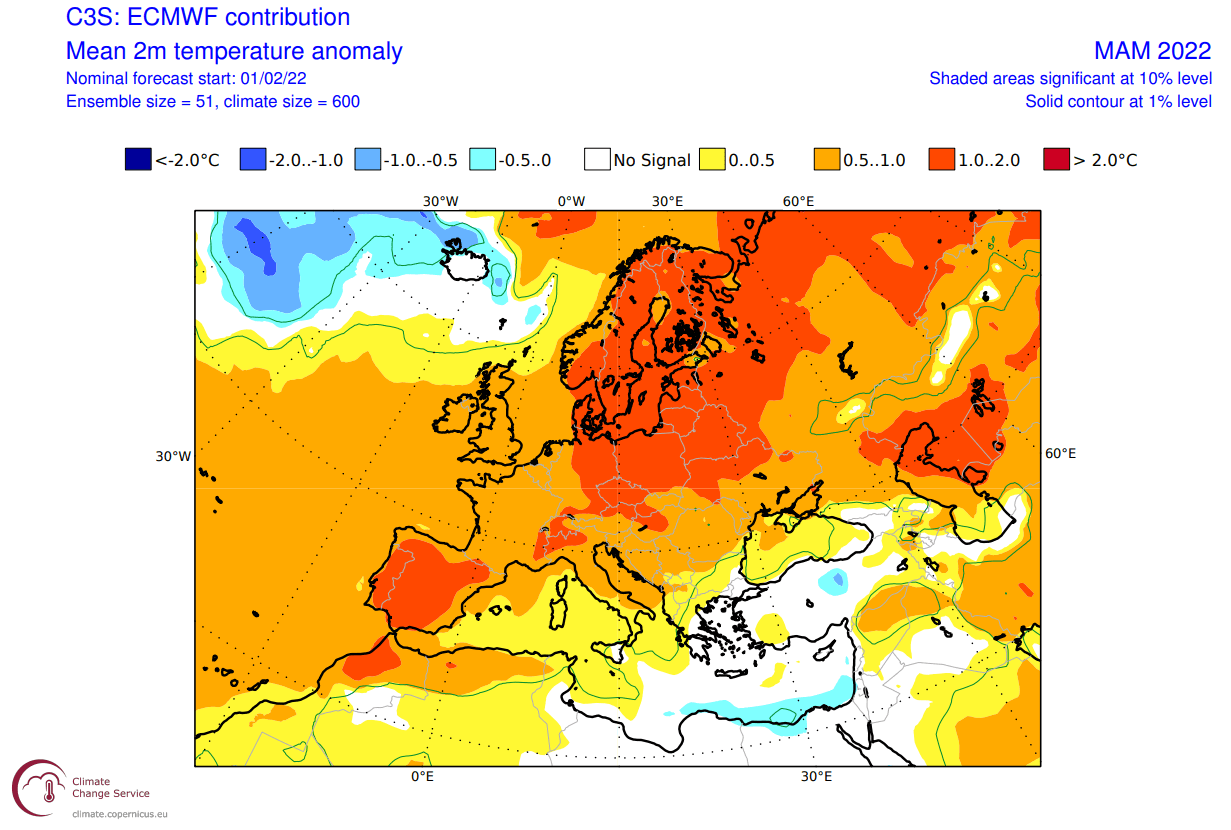
Looking closer at Europe, we see the surface temperatures are mostly above normal. Some colder anomalies are seen in the far North Atlantic, where the low-pressure systems will travel across. Far southeastern Europe is also forecast to be colder than normal, due to a more northerly flow.
Over North America, the ECMWF forecast shows colder than normal surface temperatures in Alaska and western Canada. We see a slight indication of colder air intruding into the northwestern United States. The rest of the country is mostly warmer than normal, especially in the southwest.
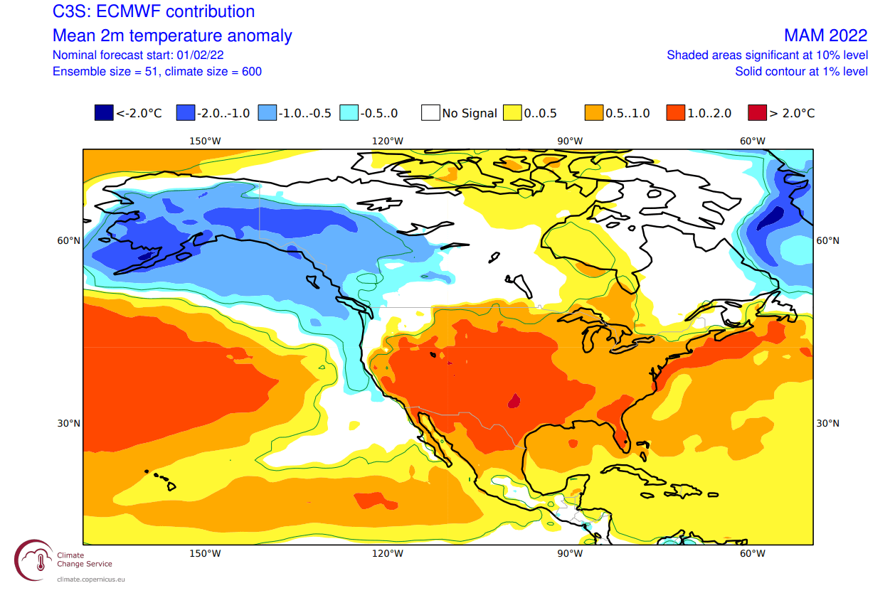
Notice a weaker warm anomaly in the eastern United States. That indicates a window for colder than normal air to spread into parts of the eastern United States. A higher chance for that is in the early part of the spring.
The precipitation anomaly forecast below shows a more normal La Nina type pattern over Canada and the United States. We see the mainland United States with wetter conditions in the northwest and the east, and drier conditions in the southwest and over Florida.
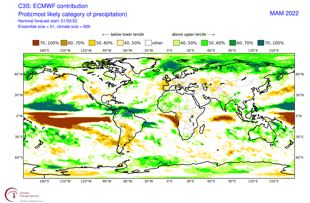
Europe is trending with more precipitation over the northern regions, following the jet stream and low-pressure systems. Drier conditions are forecast for most of western and central Europe, under high-pressure systems.
Below is the latest official Spring temperature forecast for the United States by NOAA. It shows the temperature probability, with colder to equal chances in the northwestern United States. The southern and eastern United States have a high probability of warmer than normal spring weather.

Such a pattern however still allows for strong cold air outbreaks into the Midwest and the northeast. A strong cold pool will be present in western Canada, which can be triggered to send a cold air outbreak into the United States if the pressure pattern shift occurs.
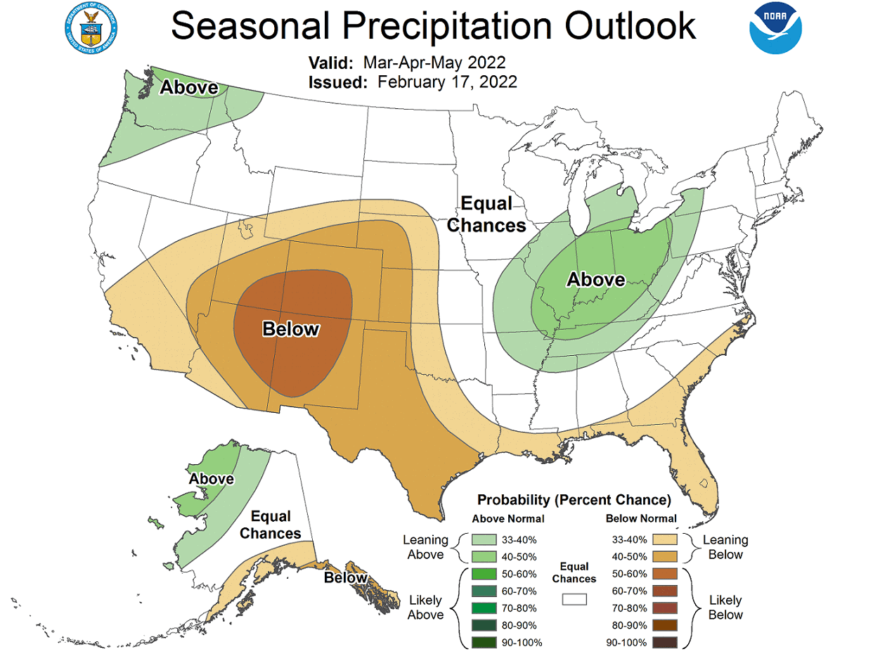
The official precipitation forecast is also quite similar to the model forecast. We see an equal-to-higher probability for more precipitation in the northwestern and the eastern United States. The southern United States is forecast to have a drier than normal spring, especially in the southwest.
We will release regular weekly and monthly updates as fresh forecasts and data are available. So make sure to bookmark our page. Also, if you have seen this article in the Google App (Discover) feed, click the like button (♥) there to see more of our forecasts and our latest articles on weather and nature in general.
SEE ALSO: