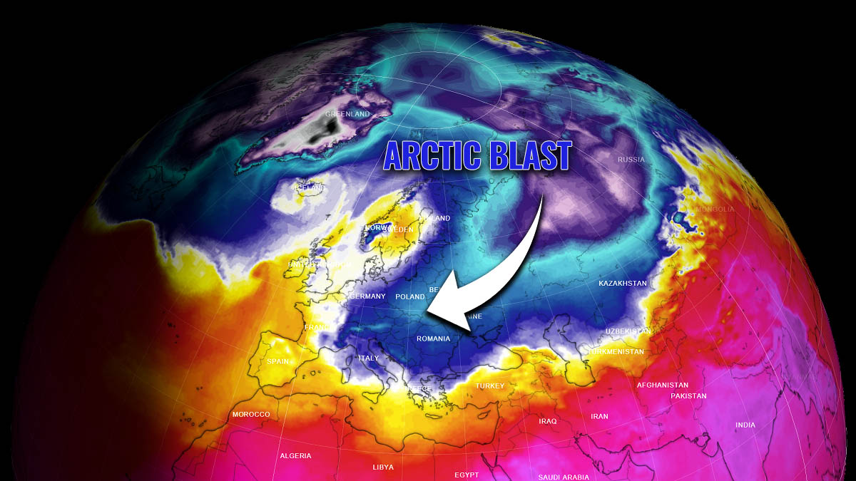
Thanks to the pattern change developing a powerful high-pressure system over northern Europe, an early March Arctic cold blast with temperatures around -15 °C is forecast to spread into eastern Europe in the coming days. The favorable flipped pattern delivers extremely cold weather and snow also farther west into central and southern Europe next week. This is due to the Polar Vortex southern lobe turning towards Russia and Europe after being parked over the United States and Canada for most of the Winter Season 2021/22.
The European continent has been lacking significant impacts of snow and cold this winter, with more or less mild weather for weeks. Contrary, the weather across the Atlantic was harsh, with a frigid cold over Canada and major winter storms across the U.S. Wondering why? That’s the Polar Vortex above us, which has been unusually strong this year.
And this is now about to change. This weekend, the general weather pattern over Europe is expected to make a significant flip, developing a strong blocking High over western and northern parts of Europe. When this occurs, it opens a corridor for the intrusion of very cold, continental air mass from Arctic Russia into Europe.
The weather dynamic over the continent will start worsening over the weekend, with a strengthening high-pressure system over western Europe first, gradually expanding towards the north. With the flow turning into northerly around the blocking High, a huge reservoir of frigid cold air will emerge from the Arctic region of northern Asia towards eastern Europe next week.
Very cold temperatures will stay there for days, spread across western Russia, Ukraine, Belarus, Poland, Slovakia, Moldova, and Romania, also expanding farther west into central and southern Europe, as well as across the Balkan peninsula. The worst cold with temperatures near 15-20 degrees Celsius below freezing is, however, forecast to overspread Ukraine and western Russia from the mid-next week into the weekend.
The weather pattern will set the European continent into a locked-in position, meaning the cold will likely extend for days, lasting into mid-March. Depending on the potential waves interacting with the cold air mass intrusion, frontal systems could also bring some decent amounts of snow across the east, Ukraine, Belarus, Romania, and a large part of the southern Balkans in particular.
The activity of the Polar Vortex is actually the main driving factor behind those major cold outbreaks across continents from the north. Before we head into deeper details regarding the potential evolution of the winter storm across Europe, here is a quick overview of what is it and how it runs our daily weather.
WHAT IS THE POLAR VORTEX?
The atmosphere of the Earth is built of six layers, rounding our planet. The majority of the weather dynamics occur in the lowest two layers. Those two are known as the troposphere and the stratosphere layer.

The most important layer for our lives is the troposphere which is sitting on the Earth’s surface. The troposphere layer is about 12 km deep, extending from the ground up high into the sky. The depth of this layer actually varies from around 8 km to almost 20 km, depending on where you live. The troposphere is the deepest above the equatorial region, and it gets much thinner above the North and South poles.
Above the troposphere, there is a much deeper layer, known as the stratosphere. This layer is near 11-50 km thick and the air in there is also very dry. The stratosphere also contains the Ozone layer, which has a vital role in the protection of our planet’s life against the potential storm impacts from the Sun or outer space.
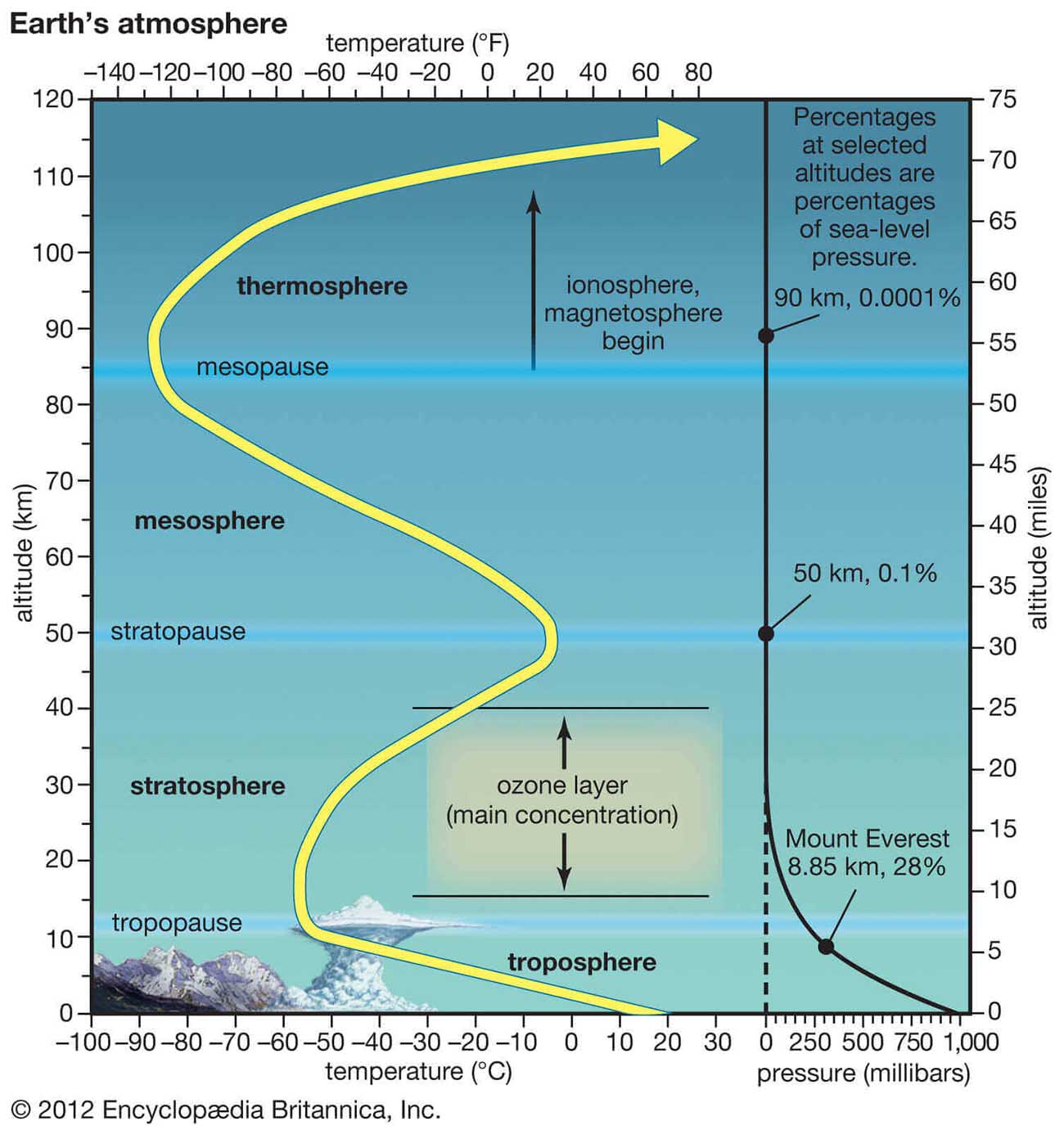
But to make our weather even more variable, there is another important part of the stratosphere that often triggers some significant large-scale weather events. This is the Polar Vortex. An enormous, tri-dimensional (3d) ring of very powerful winds grazing through the sky high above our heads. The polar Vortex is spinning around both the North and South poles, moving through the air at about 20-50 km above the Earth’s surface.
Both the troposphere and the stratosphere layers are also pretty crucial for our climate, as the Polar Vortex actually covers most of the bottom half of the atmosphere. It basically extends from the middle of Earth’s troposphere up into the stratosphere layer. It is known to have the main and major effect on the winter weather across the high and mid-latitudes as we could experience harsh winter weather conditions across North America, Europe, and Asia.

Note, that the Polar Vortex is always the strongest during the winter months in both the Northern and the Southern hemispheres.
Although the Polar Vortex spins well above our heads, it remains close-connected with the lowest parts of the atmosphere. Thus, it leads to our daily weather shape in many ways, it works as one large hemispheric circulation in general.
So all the dynamic systems, from the frigid cold weather to lack of winter weather and snow, have been triggered by the activity of the Polar Vortex above us.
How the Polar Vortex forms?
When autumn arrives, the polar regions begin to receive much less sunlight through time. This way, the cooling over the northern regions takes place and as a result, polar nights also occur for several months, with days without any sunlight following.

While the polar temperatures are dropping into deep freeze, the atmosphere layers farther south are still relatively warm as they continue to receive more energy from the Sun. Layers towards the equatorial regions to the south, therefore, remain much warmer compared to the areas farther north, leading to a high-temperature contrast between them.
The cooling of the polar regions also translates into lowering the ambient surface pressure. A very similar weather process also happens in the stratosphere layer above us, so the temperature difference between the North pole and the equatorial areas increases. Thus, creating a large low-pressure cyclonic circulation across the polar stratosphere. This is why this feature got its name as the Polar Vortex.
Putting all these puzzle pieces together, the Polar Vortex is actually acting as a very large cyclone in our atmosphere. It covers the whole North Pole during winter and becomes very intense, extending south to the regions in the mid-latitudes. Note that it is of course very much the same also in the southern hemisphere during their winter period.
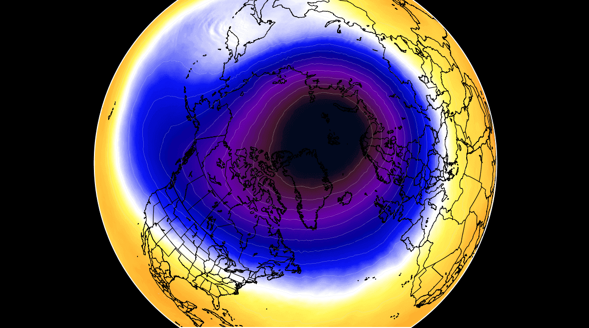
The weather model chart above hints at a very typical example of the Polar Vortex fully established above us, representing the pressure at around 30 km (18 miles) altitude. This is near the top of the stratosphere layer during the winter season.
So, to conclude, the unusually active and strong Polar Vortex this Winter season 2021/22 was the main trigger behind all those cold outbreaks and winter storms we have discussed in recent months. While the most intense part of the vortex was on the North American side for most of the winter, its southern lobe has now shifted towards Europe and northern Asia, parked over Russia this March.
UNUSUALLY INTENSE POLAR VORTEX OF 2022
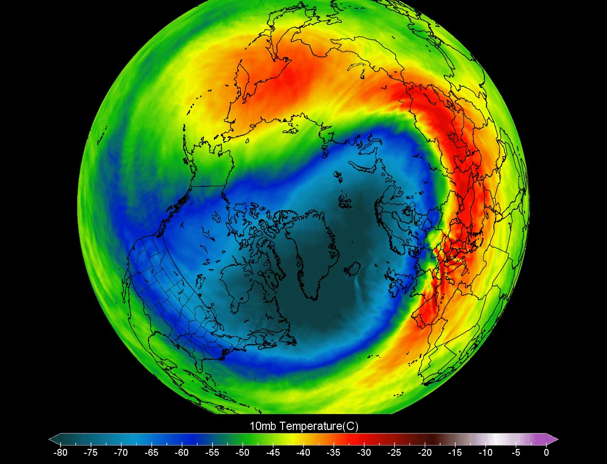
When we are monitoring the current intensity of the Polar Vortex, we look at the temperatures and their anomalies at the 10 hPa pressure level aloft. That is within the stratosphere layer we discussed above, this level is placed at around 30 km altitude.
The Polar Vortex in February and in early March is still very intense and cold, as we can see from the chart below. However, one difference is now seen, the most intense part (southern lobe) has shifted from North America above Asia and Europe.
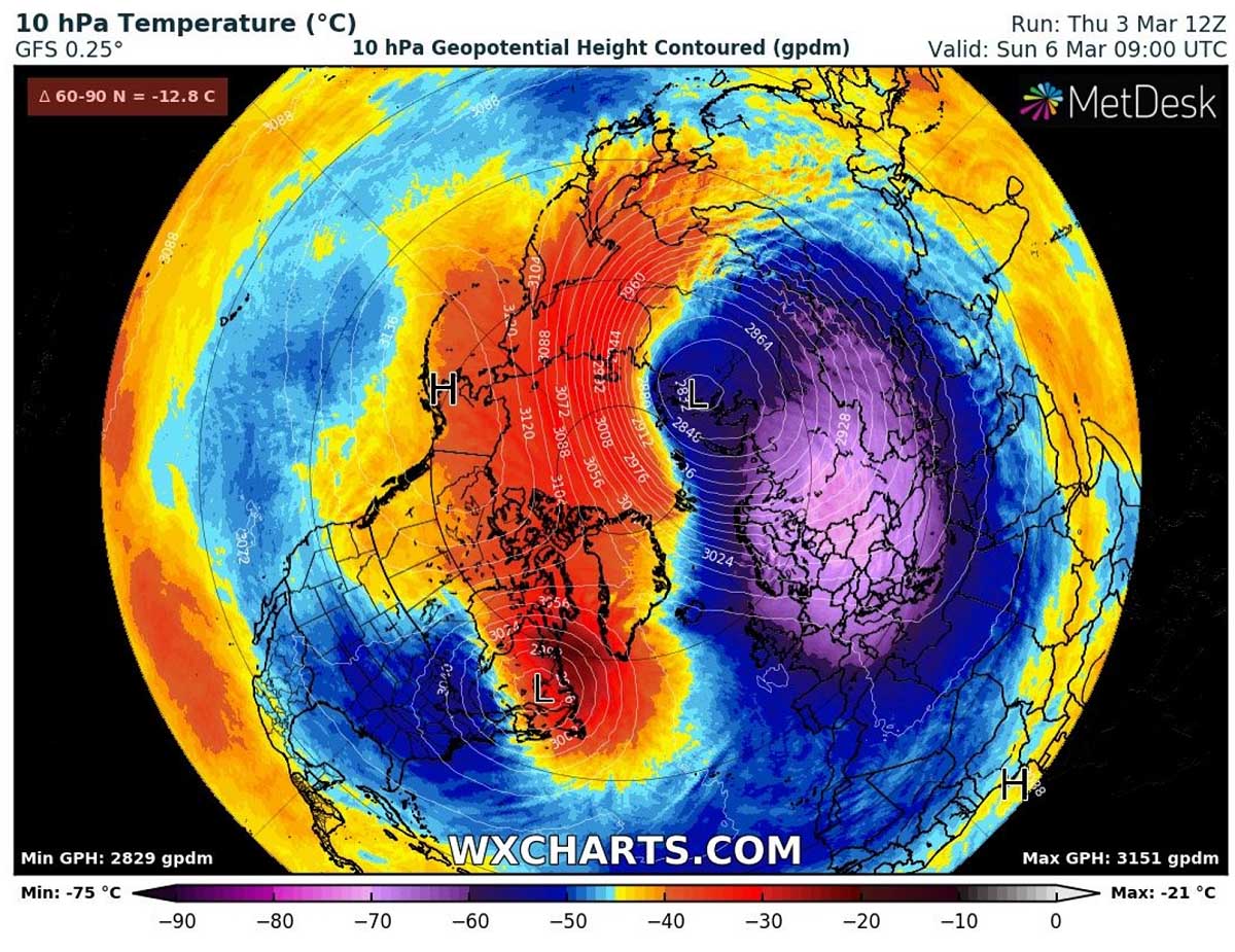
Temperatures in the core of the lobe are from -70 to -75 °C, which is extremely cold even for these levels and especially so late in the winter season or early spring. While it has been so cold over U.S. and Canada last month, the first meteorological spring month arrived, and the temperatures have now flipped. It is much warmer over Canada but particularly colder on the other side of the northern hemisphere.
These temperatures within the Polar Vortex core are nearly 30 °C below normal for this time. And this is now the main reason why the upcoming Arctic cold blast from Russia to Europe will be particularly intense in the coming two weeks. The support from the above is forecast to be significant.
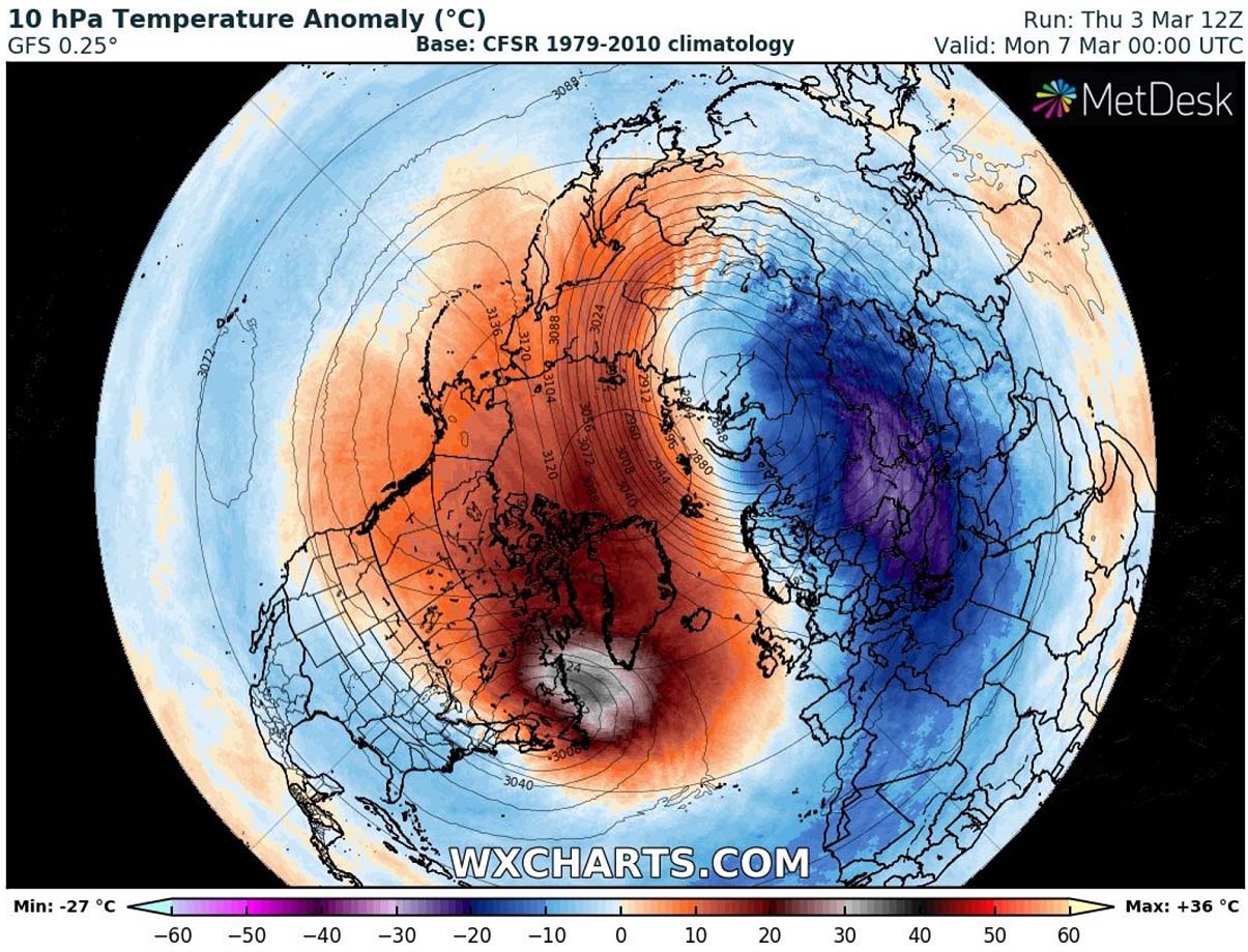
Notice how the temperatures on the other side of the vortex, above Canada and Greenland, are extremely warmer. Those are more than 35 °C above normal for early March which is pretty extreme to say at least. Both together give a combo of a massive dipole pattern.
The result of the temperature difference between air masses has a direct response to winds. Therefore, the intensity of the Polar Vortex circulation is much stronger when the temperatures are so far apart as we see. It currently spins with around 350 km/h or 220 mph up there!

During early spring, we would expect the conditions to finally wind down and begin weakening as the Winter season is coming to an end. But it just doesn’t give up yet this year. Instead of high-level winds weakening, the Polar Vortex made a flip and pushed its intense core on the other side of the northern hemisphere.
Let’s now focus on the upcoming significant weather change and Arctic cold blast from Russia into Belarus and Ukraine first, reaching Poland, Slovakia, and Romania next.
PATTERN FLIP OVER THE WEEKEND, BLOCKING HIGH DEVELOPS
The general weather pattern over the North Atlantic and Europe as we are entering this weekend reveals a somehow complex picture with higher and more stable weather to the north and lower geopotential with cooler weather to the south. But this is also the beginning of the pattern flip we’re expecting in the coming days. After damaging windstorms into western Europe not a while back, the Atlantic has calmed down under the ridge.

With the help of the Polar Vortex shift from the North American side of the hemisphere towards Europe and Asia, more cold is spread into the Atlantic Ocean. Thus, triggering more deep storms grazing towards western Europe, Iceland, and Greenland in the coming days. Ahead of these waves, an upper-level blocking pattern starts building up towards northern Europe.
The surface pressure begins rising over the northern half of Europe after Monday and strengthening through the next week. It creates a strong pressure gradient between the Low over the Atlantic and High over Scandinavia, southerly flow establishes across western Europe.

But the strength and position of the High also develop an open channel for the intrusion of cold northeasterly winds from Arctic Russia into eastern Europe. The flow keeps progressing farther west throughout the whole next week as the strength of the upper High and surface high-pressure system becomes pretty significant.
The pressure should rise above 1040 mbar over much of northern Europe and such a pattern is forecast to extend towards mid-March.
POLAR VORTEX DRAGS COLD FROM RUSSIA INTO EASTERN EUROPE NEXT WEEK
As we have discussed above, the Polar Vortex core has finally shifted its southern lobe off North America towards Russia, developing much colder high-level parts of the atmosphere over that of the world. Significantly colder weather also develops beneath the vortex, closer to the ground. Over the European continent, the locked-in pattern is becoming charted on the weather models.
A strengthening High, first emerging as an Omega blocking pattern but transforming into a Rex block later next week. We can see this strong High development through early next week on the following chart. It becomes very warm under it in the high levels.

So, through early days next week, a major pool of very cold weather first expands into western and northwestern Russia.
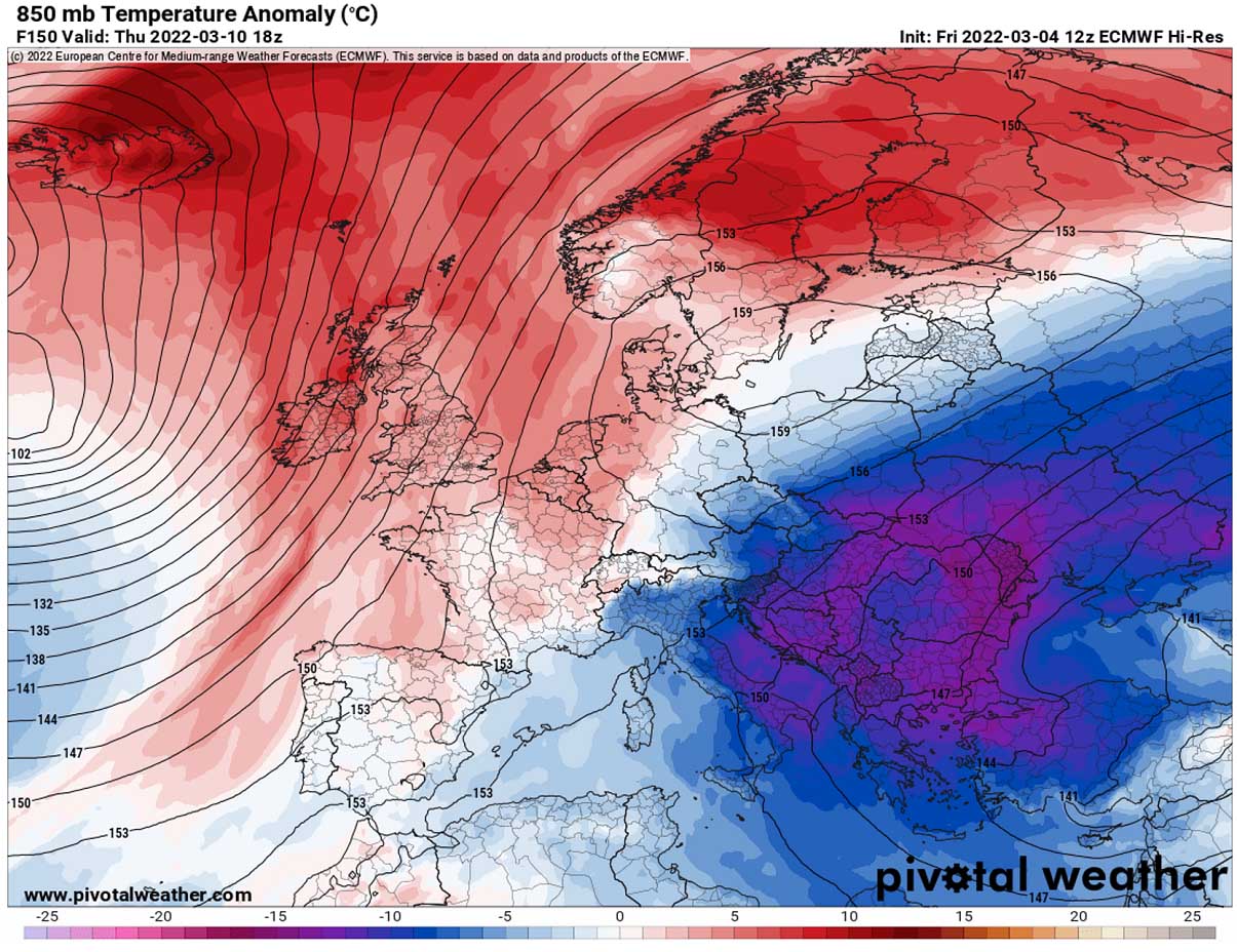
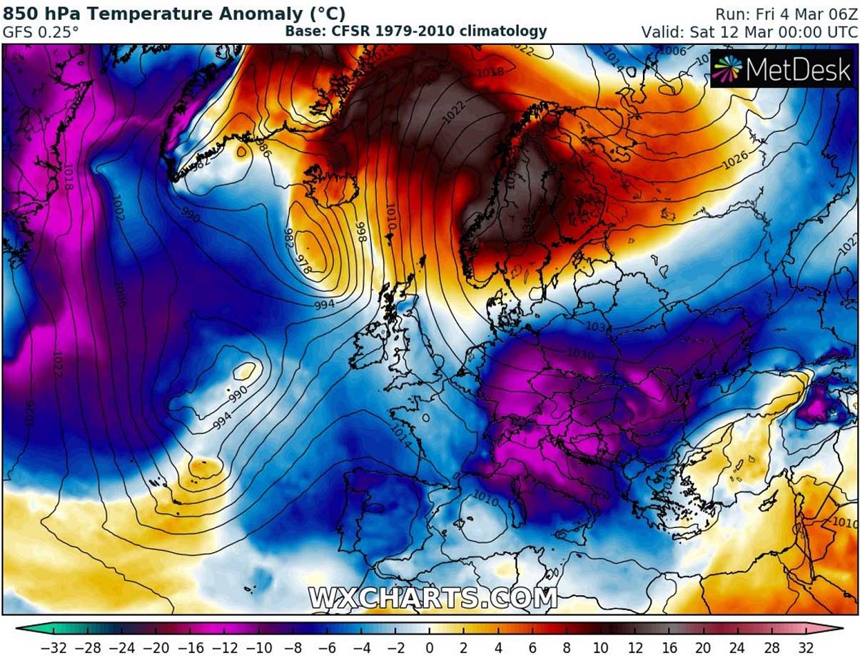
Then, it gradually continues spreading towards eastern Europe, with Belarus, Ukraine, Poland, Slovakia, Moldova, and Romania from Thursday into the weekend being the most impacted. Temperatures of even lower than 15 °C below zero at the 850 mbar level, approximately 1200 m above sea level, are forecast.

The attached chart below is the 850 mbar temperature anomaly for Thursday next week. The whole Balkan peninsula and including Moldova, Ukraine, eastern Slovakia, and southern Poland will see extremely anomalous temperatures with daytime hours being 12-15 °C below normal.
This is extremely cold for mid-March! And some areas will likely experience the coldest days so far for the Winter Season 2021/22, although we’re actually already at the beginning of the meteorological spring 2022.
The Arctic cold air mass arriving next week will also be very cold in the lowest levels. Especially from Wednesday through the next weekend. As we can see in the 2m temperature chart on Friday morning below, deep freezing temperatures will spread as far west and south as to eastern and southern France, Italy, and Greece.
Becoming particularly extreme across central Europe, and the Balkans, with potentially sliding even below -10°C in some areas on Friday morning. Farther east, across Belarus and Ukraine, temperatures will plunge well below -10 °C, possibly even below -15 °C in places!
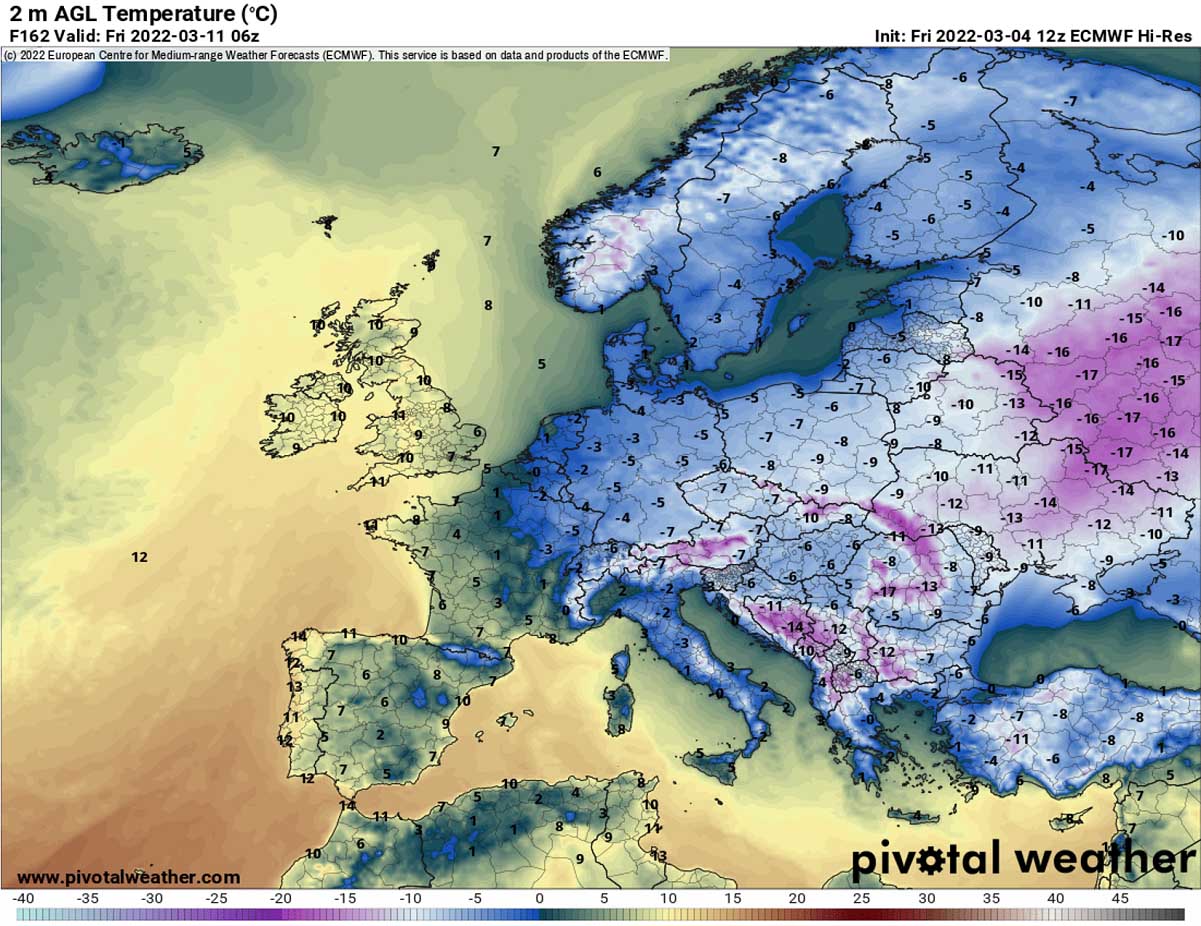
Very similar conditions are also expected on Saturday and possibly Sunday, with both mornings again with very low March temperatures in many areas.
EXTREME TEMPERATURE CONTRAST BETWEEN THE NORTH AND SOUTH THROUGH MID-MARCHK
Farther north and west of the Arctic cold outbreak over Ukraine and western Russia, much warmer weather develop under the powerful blocking High dominating most of the northern half of Europe. The high-pressure system is so strong that it does not move much for about a week. Therefore, helping to maintain stable weather for days.
The subsiding air within the strong dome of high pressure normally results in significantly warmer weather than normal. Comparison chart of pressure and 500 mbar (5 km) heights below.
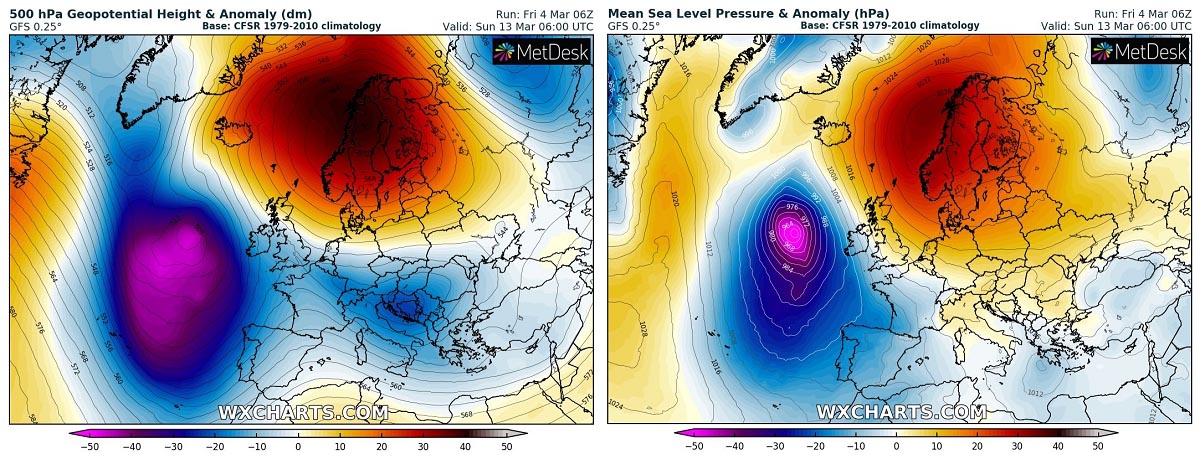
And this becomes a particularly strong temperature gradient/contrast between the north and south Europe towards the next weekend. While the temperatures across Scandinavia and the Arctic region will be more than 15 °C above normal, temperatures across central Europe will be 10-15 °C below normal.
That’s a really impressive contrast developing, leading to early spring temperatures for the north, but freezing cold across the Alpine region, Italy, and most of the Balkan peninsula. Surely far from the early spring weather to say at least.
During the second half of the week, a winter storm with heavy snowfall is also increasingly likely to develop across southern portions of the Balkan peninsula. Bringing decent amounts of snow for Serbia, Bosnia, Northern Macedonia, Bulgaria and Greece. While strong breezy winds will bring back winter feel across the northern parts of the peninsula.
Portions of the southern Balkans could see even up to around 50 cm of fresh snow next week through March 14th, similar across some parts of Turkey. Southern Italy and Greece as well, as temperatures will be very cold for March. Some new snow is also forecast across Ukraine, Georgia, and indeed the High Tatras and Carpathian mountains.

The Arctic outbreak will be gradually losing its stream towards mid-March, as the blocking High over northern Europe begins collapsing, therefore weakening the cold air mass transport through the corridor from northern Russia into eastern Europe.
Images used in this article were provided by Windy, Wxcharts and Pivotalweather.