After a record-breaking warmth recently, the weather is going to significantly flip across Canada and the United States in the coming days. A major winter storm Quinlan will blast far south across the CONUS, reaching Gulf Coast, Florida, and East Coast through Friday. Snow is forecast to spread across the South before the system becomes the next Nor’Easter bomb cyclone for the Northeast on Saturday. Meanwhile, the Polar Vortex aloft is *finally* weakening its strength and moving away from North America.
A potentially significant impact of a new winter storm Quinlan is shaping up for a large portion of the country in the next few days, with snow also for the South. The system will emerge over the Rockies on Thursday, blanket the central and southern Plains with fresh snow, from northern Texas and Oklahoma to Ohio, Kentucky, and Tennessee, and also the northern parts of Mississippi and Alabama on Friday.
DON’T MISS:
Then, the low is forecast to considerably deepen while moving across the Southeast and rapidly intensify as it turns towards the Northeast on Saturday. A major cold blast with temperatures 40-50 °F colder than just recently will follow behind the storm, putting central and northern U.S. into a deep freeze. Bringing near-freezing temperatures and unseasonably cold air also far south along the Gulf Coast of Texas, Louisiana, and Mississippi before the system ejects farther east.
With the interaction of the Arctic cold air with the warm subtropical air mass spread across the Southeast, the system will begin strengthening through Friday night, becoming the next bomb cyclone as it grazes across the East Coast, reaching New England late Saturday as a violent Nor’Easter storm. A major snowstorm is likely to develop along the low, with severe winds and potentially blizzard conditions affecting millions across the Northeast.
The cold front advancing into the warm and moist air spread across the Southeast, with Alabama, Georgia, South Carolina, and northern Florida in particular, will also enhance chances for severe thunderstorms. Severe winds, heavy soaking rain with floods, and a couple of tornadoes will be possible on Friday.
The background behind these significant cold outbreaks across the North American continent is found in the activity of the Polar Vortex aloft. It has been very active through the whole winter season, now finally losing its strength.
So, before we head into deeper details regarding the potential evolution of the winter storm Quinlan in the coming days, here is a quick overview of what the Polar Vortex is and why is it important to know when we track our daily weather.
WHAT IS THE POLAR VORTEX
The Earth’s atmosphere is built of six layers, rounding our planet. The majority of the dynamics for our daily weather occurs in the lowest two layers. Those two are known as the troposphere and the stratosphere layers.
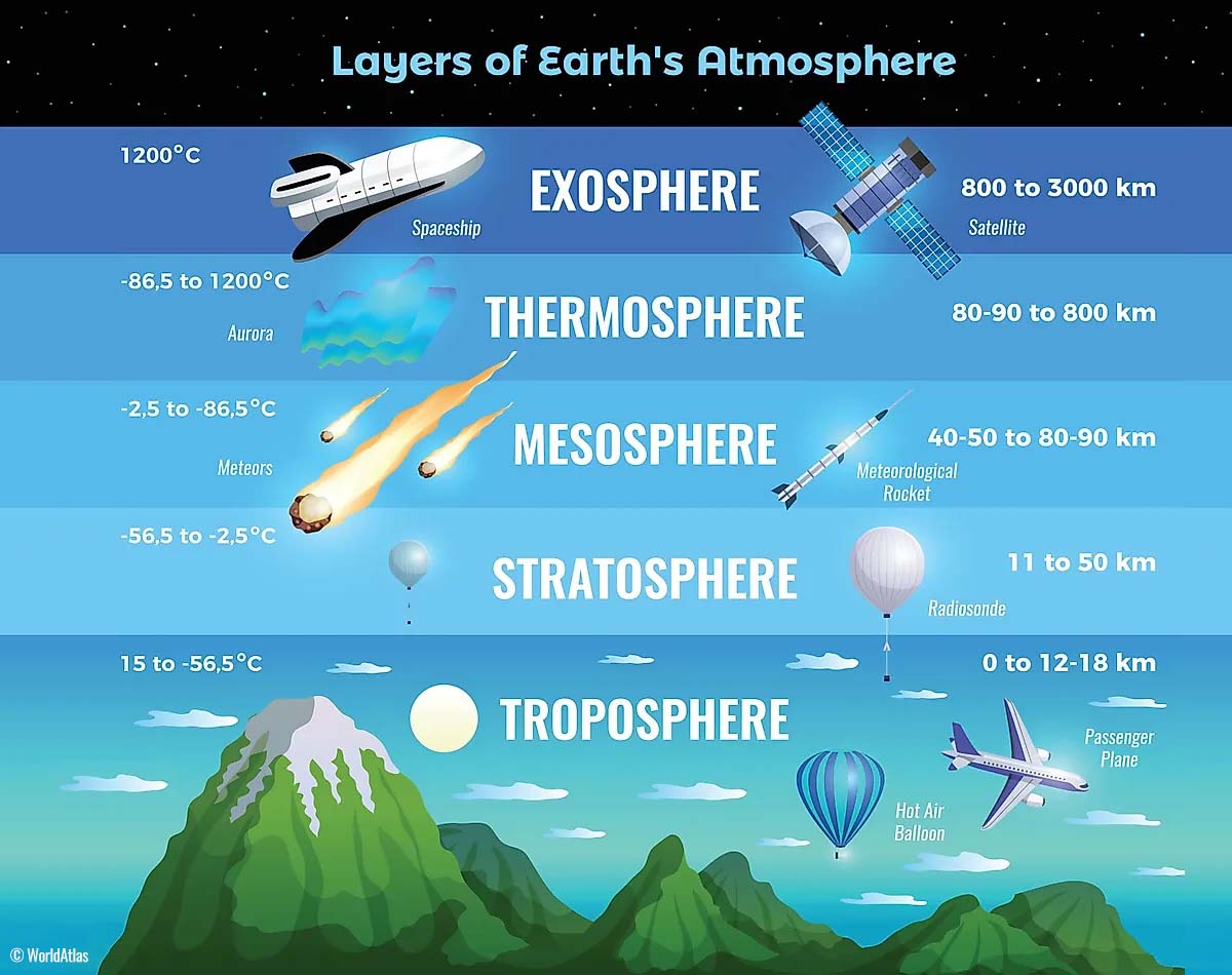
The layer close to the Earth’s surface is the troposphere. It is about 12 km deep, extending from the ground up high into the sky. The depth of it varies from around 8 km to almost 20 km, depending on where you live. The troposphere is the deepest above the equatorial region. It gets much thinner above the North and South poles.
Above this layer, there is a much deeper one, known as the stratosphere. It is an 11-50 km thick layer and the air there is also very dry. The stratosphere also has the Ozone layer, which has a vital role in the protection of our planet’s life against the potential storm impacts from the Sun or outer space.
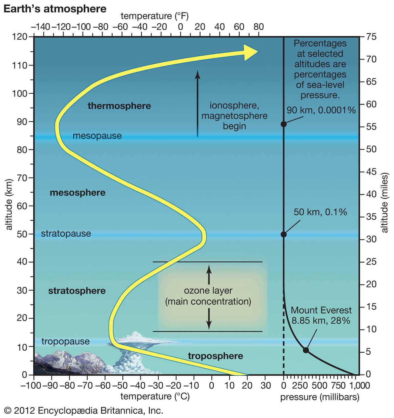
Another thing in the stratosphere, which is making our weather even more variable, often triggers some significant large-scale weather events. This is the Polar Vortex, an enormous, tri-dimensional ring of very powerful winds moving through the sky high above us. The Polar Vortex is spinning around the North Pole, grazing through the air at about 20-50 km above the Earth’s surface.
Both the troposphere and the stratosphere are actually pretty crucial for our climate, as the Polar Vortex covers most of the bottom half of the atmosphere. The vortex extends from the middle of Earth’s troposphere up into the stratosphere layer. It has the main and major effect on the winter weather across the high and mid-latitudes every year.
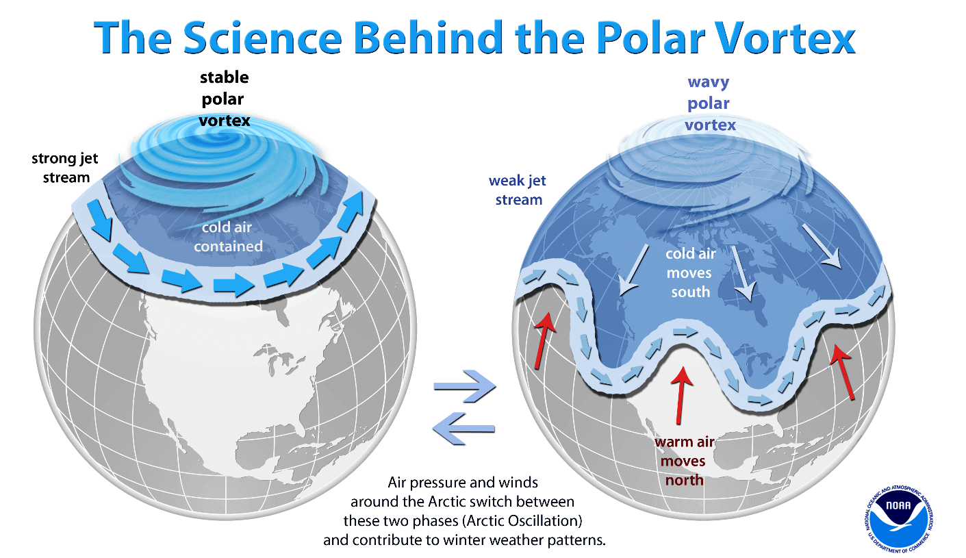
We could experience this quite a lot in Canada, the U.S. and recently also in Europe and Asia as the vortex shifted on the other side of the northern hemisphere.
The Polar Vortex is the strongest during the winter months in both the Northern and the Southern hemispheres. And although the Polar Vortex spins well above our heads, it remains close-connected with the lowest parts of the atmosphere we live in. Thus, it leads to our daily weather shape in many different ways, as it works as one large hemispheric circulation in general.

Mainly all the dynamic weather systems, from the frigid cold outbreaks in Canada and the United States to the lack of winter weather and snow in Europe this past season, have been triggered by the activity of the Polar Vortex above us.
How and when the Polar Vortex forms?
During the fall months, the polar regions begin to receive much less energy from the sun over time. This way, the cooling over the northern regions becomes strong and as a result, polar nights also occur for several consecutive months, with days without any sunlight following.

While the polar region temperatures are dropping into deep freeze, the atmosphere layers farther to the south are still relatively warm as they continue to receive more Sun’s energy. The equatorial layers to the south, therefore, remain much warmer compared to the areas farther north. So this leads to a high-temperature contrast between them.
The cooling of the polar regions also leads to lowering the ambient surface pressure, with a similar weather process also happening in the stratosphere layer. The temperature difference between the North pole and the equatorial areas increases across both layers. Thus, creating a large low-pressure cyclonic circulation across the polar stratosphere and hence where this feature got its famous name – the Polar Vortex.
Putting all these pieces of the puzzle together, the Polar Vortex is acting as a very large cyclone in our atmosphere. It expands across the whole North Pole during winter months and becomes very intense at times, extending south to the mid-latitude regions. The same is also happening in the southern hemisphere during their winter period as Polar Vortex intensifies around the South Pole.
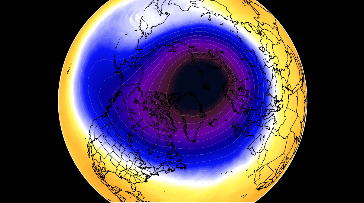
The weather model chart above hints at a very typical situation of the Polar Vortex fully established above us, representing the pressure at around 30 km (18 miles) altitude. This area is near the top of the stratosphere layer during the winter season.
To conclude, the unusually active and strong Polar Vortex during the Winter season 2021/22 was the main trigger behind all the cold outbreaks and winter storms over North America in recent months. While the most intense part of the vortex, its southern lobe, was on the North American side for most of the winter, this feature has now shifted towards Europe and northern Asia this March. The upcoming cold blast could be one of its final pushes this far south.
INTENSE POLAR VORTEX OF 2022 WAS UNUSUALLY INTENSE
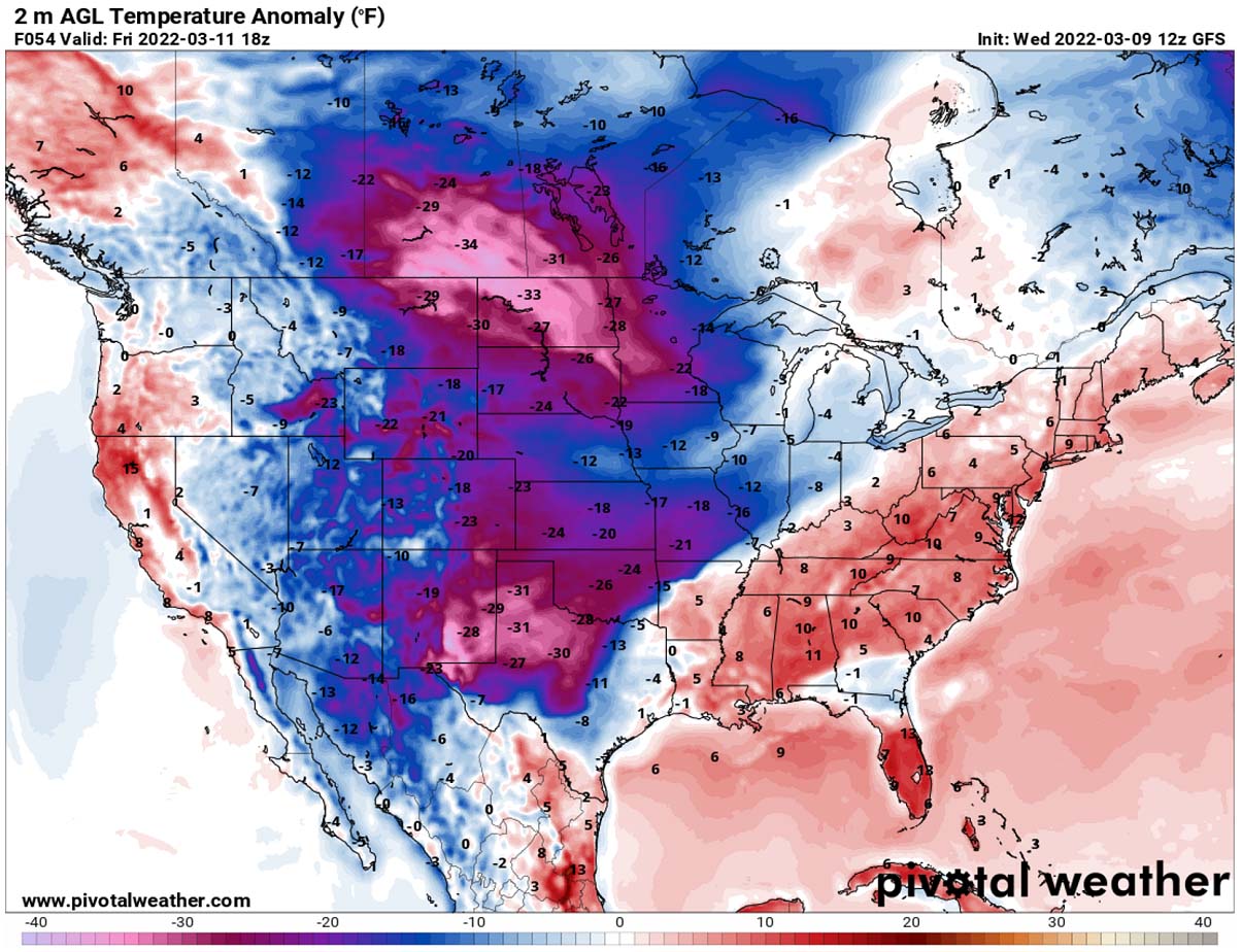
When we are monitoring the intensity of the Polar Vortex, we look at the temperatures and their anomalies at the 10 hPa pressure level. That is directly within the stratosphere layer we discussed above. This level is placed at around 30 km altitude.
The Polar Vortex during February and in early March is very intense and cold, as we can see from the following chart below. However, one difference is now seen, the most intense part of its southern lobe has shifted from North America towards Asia and Europe.
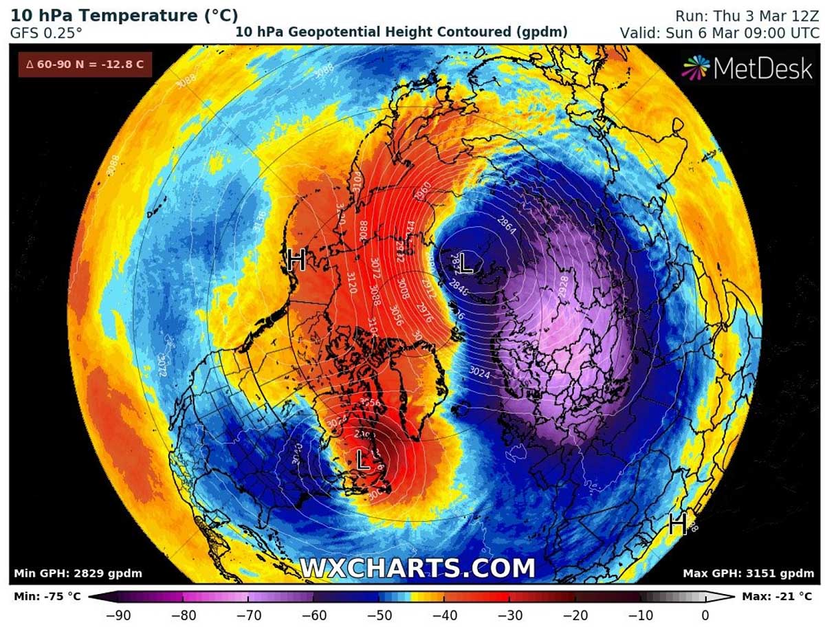
Temperatures in the core of the lobe are from -65 to -75 °C, which is extremely cold even for these levels and especially for early spring. The temperatures within the Polar Vortex core are nearly 30 °C below normal for this time as it shifted on the other side of the hemisphere. Notice how the temperatures on the other side of the vortex, precisely above Canada and Greenland, are extremely warmer.
The temperature anomaly there is around 30 °C above normal for mid-March which is pretty extreme to say at least. Both together give a combo of a massive dipole pattern over the northern hemisphere.

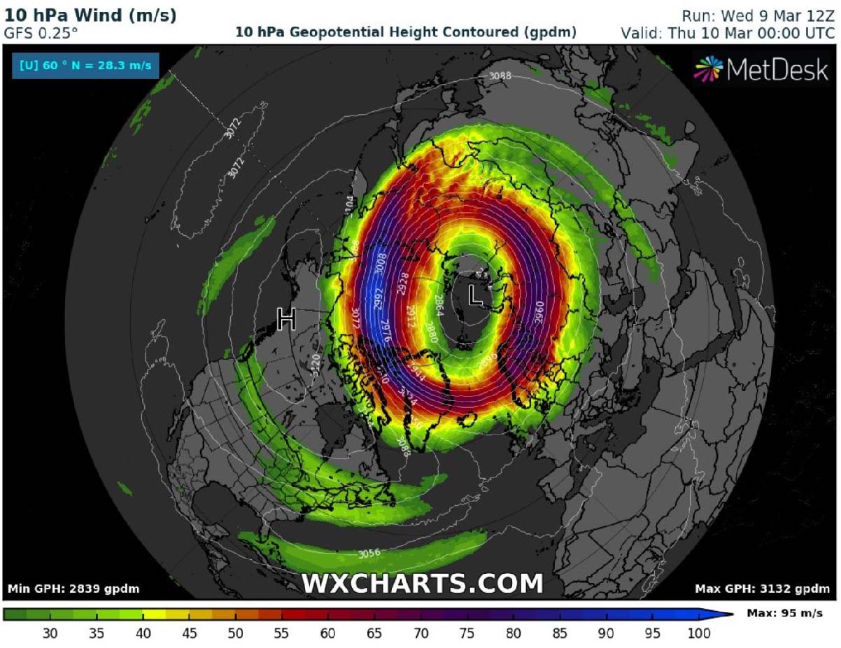
The result of the temperature difference between air masses has a direct response to intense winds. Therefore, the intensity of the Polar Vortex circulation is much stronger when the temperatures are so far apart from each other as we can see. The vortex is currently still spinning with around 220 mph (350 km/h) up there!
During early spring, we normally expect the conditions to finally wind down and begin weakening as the Winter season is coming to an end. But the Polar Vortex just doesn’t give up yet this year. Instead of high-level winds weakening, it made a flip and pushed its intense core on the other side of the northern hemisphere.
At the same time, released another cold blast towards the ground across Canada and the United States this week. Let’s now focus on the upcoming major Winter Storm Quinlan across the continent in the coming days.
POLAR VORTEX TRIGGERS NEW WINTER STORM QUINLAN ACROSS THE U.S.
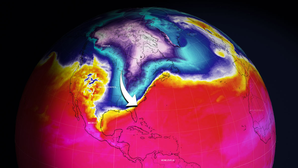
The upcoming winter storm Quinlan will affect tens of millions across the eastern third of the United States. From the deep South along the central Gulf Coast as frigid Arctic air meets the warm air, leading to a surface depression turning towards the Northeast and literally exploding into a bomb cyclone on Saturday.

It is actually a quite typical occurrence for March, as parts of the Midwest receive snow while Southeast parts of the country get severe thunderstorms and tornadoes. Just like it happened the past weekend with deadly twisters in Iowa. More tornadoes will be possible across the Southeast before the cold air arrives late Friday.
The impact of this new system will start with a frigid Arctic cold blast, surging south out of Canada into the Great Plains and Rockies through Friday, pushing towards East over the weekend. It will be pretty extreme for mid-March, so likely to set new daily records across many areas from North to the East U.S.

Ahead of the cold pool system, the Arctic front will be surging south, leaving several inches of snow from the Rockies to Nebraska and Iowa through Thursday night. Favorable wind patterns should bring a lot of snow for the eastern Colorado foothills, including the Denver metro eastward into the Plains from Wednesday night into Thursday morning.
With the front progress towards the east-southeast, snow is forecast to spread east and south into Kansas, parts of Oklahoma, and possibly also into far north Texas by Thursday night. Continuing into the Ozarks, extending northeastward across Illinois towards the Great Lakes. Roads will be slippery, with travels disrupted and delays in some areas.

Farther south, ahead of the Arctic front, the very warm and moist air mass will lead to heavy rain and downpours, including severe thunderstorms from the Gulf Coast into the Southeast coast, from midday Friday through early Saturday.
The Storm Prediction Center (SPC) has issued a Slight Risk for severe thunderstorms as marked below.

Southern Alabama, northern Florida, and southern and central Georgia into middle and coastal South Carolina and eastern North Carolina will be in the main spot for some damaging storms.
A couple of supercell thunderstorms with tornadoes will be possible as well.
THE ARCTIC BLAST WILL REACH DEEP SOUTH
With the southern lobe of the Polar Vortex shifting from North America towards Europe and Asia, its delayed effect is coming into the U.S. this week. A strong blocking High is strengthening over Canada, gradually expanding towards the United States from Thursday into the weekend.
This is a quite typical occurrence before the massive continental Arctic airmass intrusion turns towards the south.
Normally, a high surface pressure develops under a powerful High in the upper levels. It will again be very high atmospheric pressure with nearly 1040 mbar in its center Thursday night across the northern and western U.S.

The surface High will cause the northerly winds to transport a much colder, frigid cold Arctic air mass from central Canada towards the central and southern Great Plains. The meridional flow will drag the temperatures down significantly through time, starting Thursday and intensifying on Friday and Saturday.
As we can see from the chart below, the much colder air mass in the wake of the Arctic front will be the strongest across the North on Friday, spreading deep south into the central U.S. on Saturday, then moving towards the east as the front advances further through late Saturday. The 850 mbar (approximately 1200 m ASL = 4000 ft) will bring temperatures about 25 degrees C below normal on Friday.

Saturday will bring the core of the Arctic cold pool across the Midwest, central Mississippi Valley to Ohio Valley. With temperatures again about 15-20 °C below normal in the lowest levels.
The extremely cold air at the ground will first spread from southern Canada into the Northern Plains and Rockies through Thursday morning, spreading into the Upper Midwest during the day on Thursday. Air mass will be nearly 35 °F below normal across parts of North Dakota and northern Minnesota on Thursday, which is pretty intense even for these areas that are used to the frigid cold. This will put this region back into a deep winter freeze.
Notice also southern High Plains will be pushed into a deep freeze. With temperatures around 30 °F below normal across eastern New Mexico, West Texas, and OK/TX Panhandles. We can see the air mass across the Southeast will still be warm, but the sharp Arctic front will be racing east pretty fast.
Saturday morning will be extremely cold for the central portions of the U.S., from the Upper Midwest down to the Gulf Coast. While temperatures will be nearly 40 °F below normal in Minnesota, it will be just a shy warmer across eastern Kansas, Oklahoma, Missouri, and northern Arkansas. With about 25-35 °F colder than normal in the morning. Also, daytime temperatures will not be much warmer, thanks to fresh snow on the ground as well.

It will be 20-25 °F colder than normal also across central Texas, around 20 degrees along the deep south Gulf Coast. The pretty cold morning also along the central Gulf Coast, from southeast Texas to western Florida Panhandle.
The attached chart below is a forecast of morning lows on Saturday. Even below -10 °F across eastern North Dakota and parts of Minnesota, in the single digits across Nebraska, Iowa, Wisconsin to northern Missouri and Illinois. Near or slightly below freezing also almost down to the Gulf Coast in Texas, central Louisiana. Below freezing across most of Mississippi, northern Alabama, and northwest Georgia.

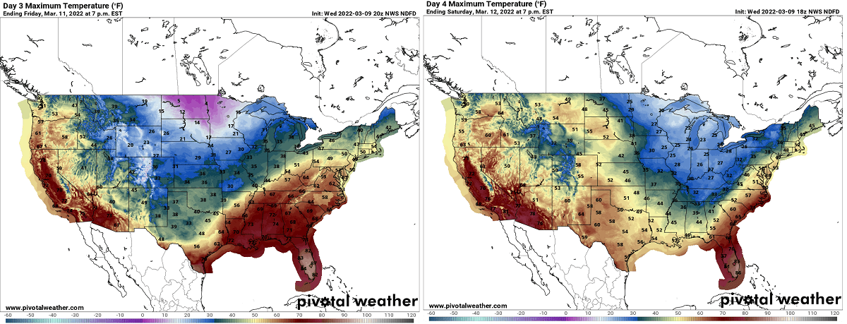
On Friday, daytime temperatures will stay below freezing north of the line from Colorado to Kansas and Illinois, in the low 70s across the far Southeast.
On Saturday, temperatures will be warmer across the Plains but remain below 32 °F from eastern Dakotas to central Midwest, Ohio Valley to the Northeast. The Northeast U.S. will be especially cold due to strong winds ongoing closer to the winter storm Quinlan emerging from the East Coast.
While the cold will be pretty intense for mid-March across many areas, the highest concern over the weekend is the rapidly developing low that will emerge from the interaction of the Arctic cold and the tropical air, clashing together off the Southeast U.S. on late Friday.
This will lead to explosive development and a rapidly deepening system tracking the classic path along the East Coast into New England and southeast Canada.

It will turn towards the Northeast through Friday night first, becoming the next Nor’Easter bomb cyclone this year. Deep snow, blizzard conditions, and severe winds will follow for millions, disrupting travels and causing delays.
A BOMB CYCLONE, WHAT IS IT AND HOW SUCH POWERFUL STORM ACTUALLY FORMS?
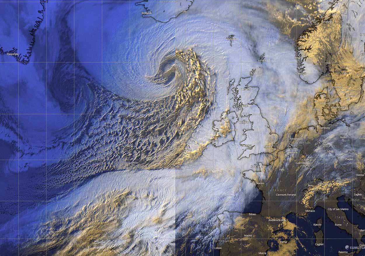
Along the East Coast and over a portion of the North Atlantic, some very powerful storms look really impressive on the satellite. But those are very dangerous systems, and meteorologically speaking, also very didactic and outstanding with their development. When we see a very strong pressure drop within a period of 24 to 36 hours, we could classify the storm as a bomb cyclone.
In other words, this means that the surface low intensifies so fast that its central pressure is falling very (or often extremely) rapidly. A bomb storm occurs when so-called explosive cyclogenesis with the extremely rapid deepening of its barometric pressure is forecast. This process is known as bombogenesis.
Such systems are the classic Nor’Easter storms during winter months.

Technically speaking, a pressure fall of at least 24 millibars within 24 hours is the minimum criteria that the cyclonic system needs to meet to be officially classified as a bomb cyclone. This is a non-tropical storm, also known as an extratropical low, and develops extremely rapidly from a classic low-pressure system. An example of such bomb cyclones is seen above, the typical Nor’Easter storm along the U.S. coast, very similar to the system we are expecting to face this weekend.
This kind of storm normally grows very large, dominating a large portion of the Atlantic ocean of Northeast U.S, their general movement is towards the northeast. The cyclone’s large size produces very intense and often extremely severe, even hurricane-force destructive winds, associated with the sting jet phenomenon. Being so large, it also generates major waves and swells, which leads to beach erosion and damages the coastal areas.
So, quite similar to the classic extratropical cyclone, bombs are fueled by variations in the temperature. Mainly between the warmer temperatures over the Atlantic, originating from the tropical region, Gulf of Mexico or Caribbean, mixing with much colder temperatures coming from the Arctic region. This also occurs vertically throughout the atmosphere and is exactly the case we will be seeing these days.
These types of cyclones are completely different from tropical cyclones that we normally see during the Atlantic hurricane season. Those systems receive their fuel/energy from extremely warm sea surface temperatures found in the tropical region. Below is an example of both, a tropical storm (hurricane Epsilon) and an extratropical storm simultaneously ongoing in the North Atlantic in October 2020.

Typically, the eastern coasts of the North American continent and Northwest Atlantic Ocean are the perfect breeding grounds for these types of cyclones, normally from the late fall and winter months into early spring. Here, an interaction of the Arctic cold continental air mass and warmer, moist ocean tropical air mass provides a lot of energy for these systems to rapidly develop.
Very often Nor’easter storms literally explode over the Atlantic coast.
Bomb cyclones are actually a pretty common occurrence during the winter months in the North and Northwest Atlantic, although they can occur all year round. These, so-called ‘cyclonic bombs’ also include post-tropical systems that sometimes rapidly reform from a decaying tropical cyclone when they travel far north towards Iceland, Greenland, or even west-northwest Europe.

Annually, there are about 60-70 such cyclone-type formations on Earth, and about two-thirds of them occur in the Northern Hemisphere. Particularly off the east coasts of the U.S. and the North Atlantic, with some of those becoming violent Nor’Easter storms.
A NOR’EASTER DEVELOPS TOWARDS THE NORTHEAST AND NEW ENGLAND ON SATURDAY
The surface low begins rapidly strengthening after ejecting the Southeast U.S., interacting with the influx of very warm and moist air from the south through early Saturday. Then, the further push of the Arctic front from the west, drags the low towards the East Coast, while being explosively deepening into a powerful Nor’Easter.
Weather conditions will rapidly worsen, with heavy rain and winds along the coastal areas and rain turning to heavy snow behind the front. Whiteout conditions are expected from Ohio Valley to New England during the most intense snowfall from Saturday morning into the evening as the system advances northeast.
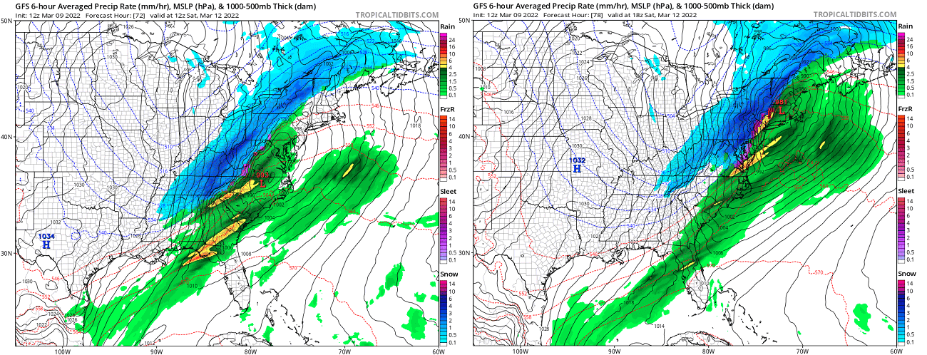
The surface chart below reveals the strong pressure difference between the deep Nor’Easter bomb cyclone again the High to the west. More than 60 mbar of pressure difference will be between New England (Low) and the Gulf Coast (High) on Saturday evening.
Just by looking at the pressure lines (isobars), we can judge that the cold, breezy northerly winds will be intense between both systems. Delivering Arctic cold air mass into the eastern half of the U.S. on both Saturday and Sunday as we discussed earlier.

The Nor’Easter will likely reach its peak intensity somewhere near or very near the coast of the New England coast on Saturday, possibly with pressure in the 960s before deepening further while ejecting into southeast Canada near Newfoundland.
At the time the developing system emerges across the Mid-Atlantic, its pressure gradient considerably tightens against the higher pressure building up beneath the Arctic cold pool over the land. A typical occurrence when we face a powerful Nor’Easter storm. This will then introduce locally severe winds along the East Coast and New England in particular.

Winds will be the strongest there, causing coastal flooding and erosion as well, thanks to high sea waves that will result from the winds as a result of a strong pressure gradient in place. High winds in some coastal areas could be damaging and strong enough to knock out power by fallen trees.
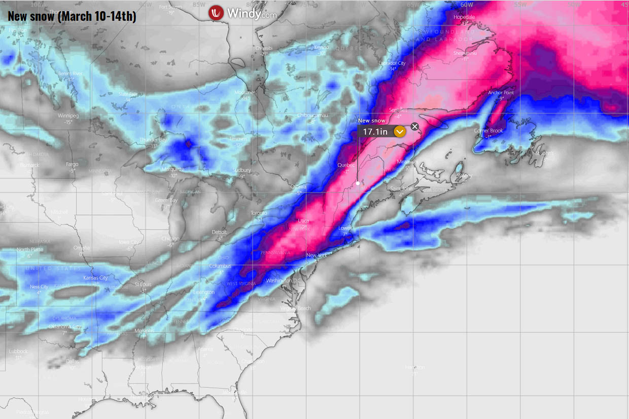
Significant snow amount will develop across much of the mid-Atlantic and Northeast, with a deep snowpack swath from Ohio Valley into New England and farther northeast into eastern Canada. Snowfall will be heavy in many areas, all depending on how north the bomb cyclone will track. Around 10-20 inches will locally be possible.
Strong to severe winds, combined with heavy snowfall, becoming dry snow once the Arctic air spreads from the north, will also lead to blizzard conditions. Thus, reducing visibility and leading to travel disruptions, delays, and also flight cancelations. Snowdrifts could lead to road closures in some areas from New York state to Maine.
Stay safe and follow your national weather service for the latest warning and local details.
Images used in this article were provided by Windy, TropicalTidbits, and PivotalWeather.