Meteorological Fall is here. Looking ahead, we can already see clear signs emerging of the new La Nina influence on the Fall weather patterns across the Northern Hemisphere, especially North America, which will continue into Winter 2022/2023.
The meteorological Fall covers three months, from September to November. This is the transition season from the warmest part of the year to the coldest part. So, for this reason, it can be quite dynamic.
As mentioned many times, an important player for Fall weather this year will be the La Nina, with a known history of its seasonal weather impacts. So before going into the forecast, we will quickly look at how La Nina works and what its history of impacts can show us for the future.
OCEANS AND WEATHER
La Nina is a cold phase of the large and powerful oceanic ENSO oscillation. ENSO is short for “El Niño Southern Oscillation.” This is a region of the tropical Pacific Ocean, which shifts between cold and warm phases.
The tropical trade winds (winds that circle the Earth near the equator) usually initiate or stop a certain phase, as they mix the ocean surface and can change the ocean currents.
The image below from NOAA Climate shows the typical circulation during a negative ENSO event (La Nina). Air is descending in the eastern Pacific, creating stable and dry weather conditions, while rising air in the western Pacific causes frequent thunderstorms and plenty of rainfall.

This way, ENSO significantly impacts the tropical rainfall and pressure patterns, impacting the delicate ocean-atmosphere weather system. This ocean-atmosphere interaction system distributes the ENSO influence globally over our weather seasons.
We usually observe a global change in pressure patterns during the emergence and duration of an ENSO phase. Each phase has a unique impact on the tropics and, with some delay, also on our weather.
The cold ENSO phase is called La Nina, and the warm phase is called El Nino. The temperature anomalies (warmer/colder) in the tropical Pacific region determine the ENSO phase.
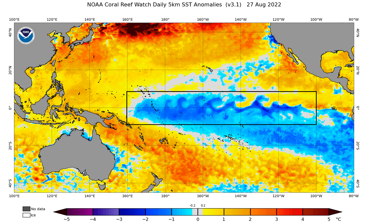
Below we have a zoom-in on the tropical Pacific, with the ENSO region marked. You can see the cold anomalies, which is the currently active La Nina.
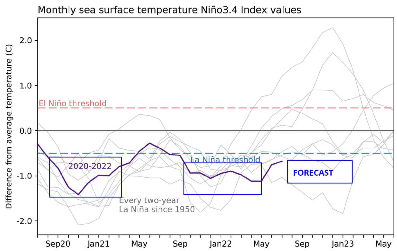
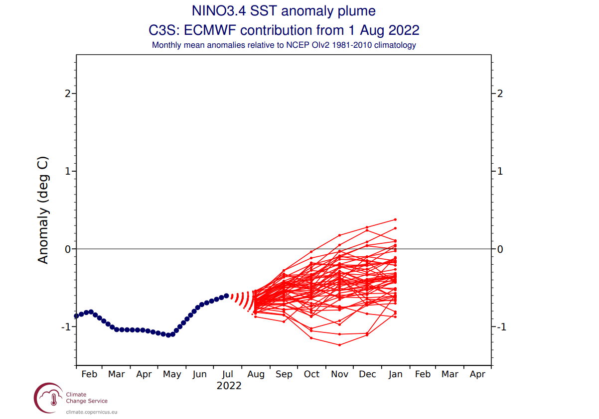
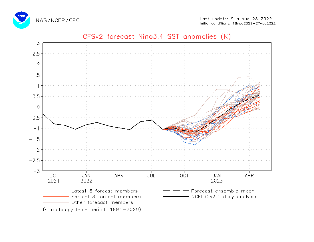
Below, you can see the last two years of ocean anomalies in the ENSO region. You can see the first La Nina event in 2020 and a second-year La Nina in late 2021. A third-year event is forecast to develop over the Fall and Winter 2022/2023.
To better understand the ENSO development, we produced a video showing the La Nina anomalies from late Spring over the summer. The video below shows the cold ocean anomalies in the equatorial Pacific. Notice the “waveforms” across the region as trade winds push the surface waters west..
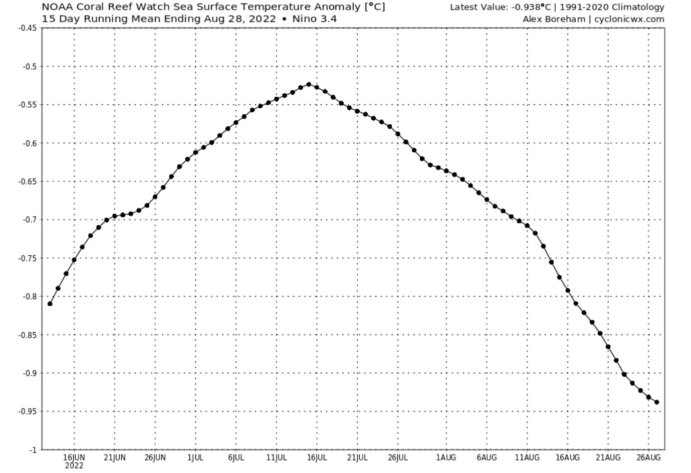
Looking at the image below, we can see the temperature progression across the main ENSO region. La Nina has weakened in the first half of Summer. But since mid-July, the La Nina has been strengthening (cooling) again.
A specific phase (warm/cold) usually develops around late summer or early Autumn. So a re-strengthening of an ENSO phase is expected in this period.
ENSO FALL/WINTER FORECAST
Below is an analysis/forecast graphic by ECMWF, which shows the forecast of the main ENSO 3.4 region. We can see the continued negative anomalies and cooling into Fall and also Winter 2022/2023. However, the forecast average stays within the La Nina phase threshold going into Winter.
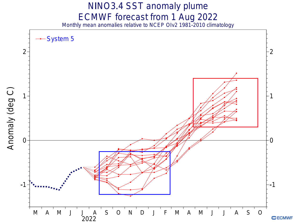
The ECMWF global ocean temperature forecast shows that La Nina is present across the entire equatorial Pacific Ocean during Fall. Based on the anomalies, this looks like a moderate La Nina event.
Below we have an analysis/forecast graphic by ECMWF, which shows the long-range forecast of the main ENSO region. The La Nina conditions will prevail over the Fall and Winter. But a weakening of the La Nina is expected for early next year, with an El Nino possible later in the year.
LA NINA AUTUMN WEATHER PATTERN
Several Fall/Winter seasons have had an active La Nina phase. If we count last year, there were 10 such seasons in the past 25 years.
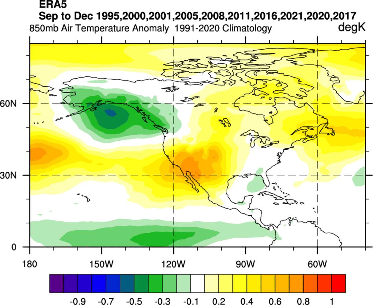
A more direct ENSO influence can be found in North America. For this reason, we produced special graphics that combine 10 of the last La Nina Fall seasons. They reveal the average weather pattern during a La Nina Fall season.
First, we have the pressure anomaly pattern, covering the September-December period. We see three areas of high-pressure anomalies and a low-pressure zone over Alaska and western Canada.

A high-pressure anomaly in the North Pacific is a typical La Nina signature in all seasons. But in Autumn, a high-pressure area over is common in the western United States. There is also a high-pressure anomaly in the North Atlantic.
Looking at the temperature patterns, we see a cold anomaly over Alaska and the Pacific Northwest, under the influence of the low-pressure zone. Warmer temperatures are prevalent in the western and southern United States.
A neutral to cool anomaly is present over the southeastern United States. There are indications that some La Nina seasons favor lower than normal temperatures over this part of the country.
The precipitation analysis shows a drier than normal pattern over most of the southern and central United States. More precipitation is over the Pacific Northwest, parts of the northeastern United States, and eastern Canada.

Knowing what La Nina is and how it can change our weather, we will now look at the actual forecasts to see if we can find its influence in the coming Fall 2022 weather season.
OCEAN DIPOLE MODE
But ENSO is not the only anomaly that will influence the upcoming months. Another such oceanic region can be found in the Indian Ocean.
There we have the Indian Ocean Dipole (IOD), also called the Dipole Mode Index. It consists of two poles, hence the name “dipole.” The east part is located around Indonesia, and the west part covers the western Indian Ocean.
The IOD is an imbalance in ocean temperatures between these two regions. Changes in temperatures between the teo areas occur due to the change in trade wind patterns. Thus, the IOD has two phases, positive and negative.
Below is the latest ocean analysis, which shows a temperature difference between the eastern and western regions of the Indian Ocean. You can see warmer anomalies in the east, but colder anomalies prevail in the west.
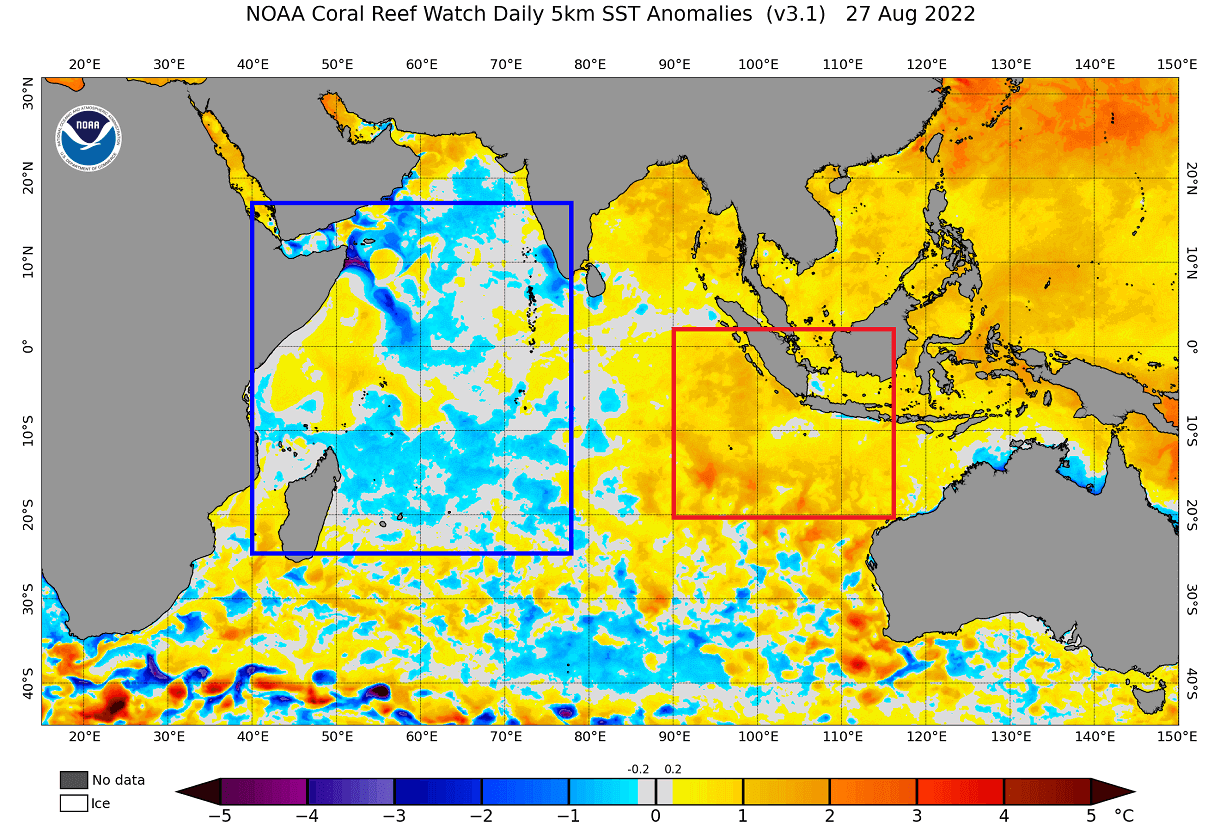
We now know that when the eastern regions are warmer, that signals a negative IOD phase. So more warming in the east and cooling in the west is expected.
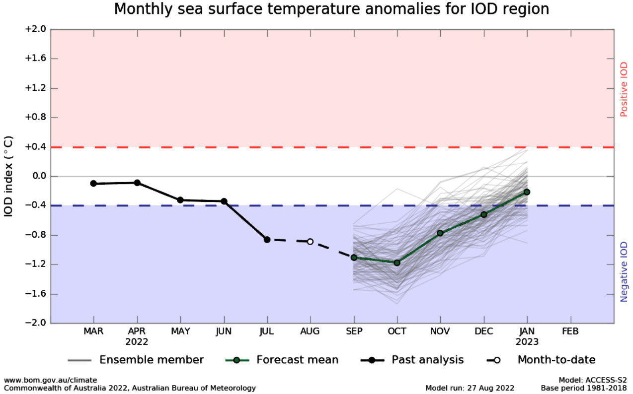
You can see this development in the BOM seasonal forecast below. A strong negative IOD phase is expected going into Fall, with the atmospheric interference expected to last into Winter 2022/2023.
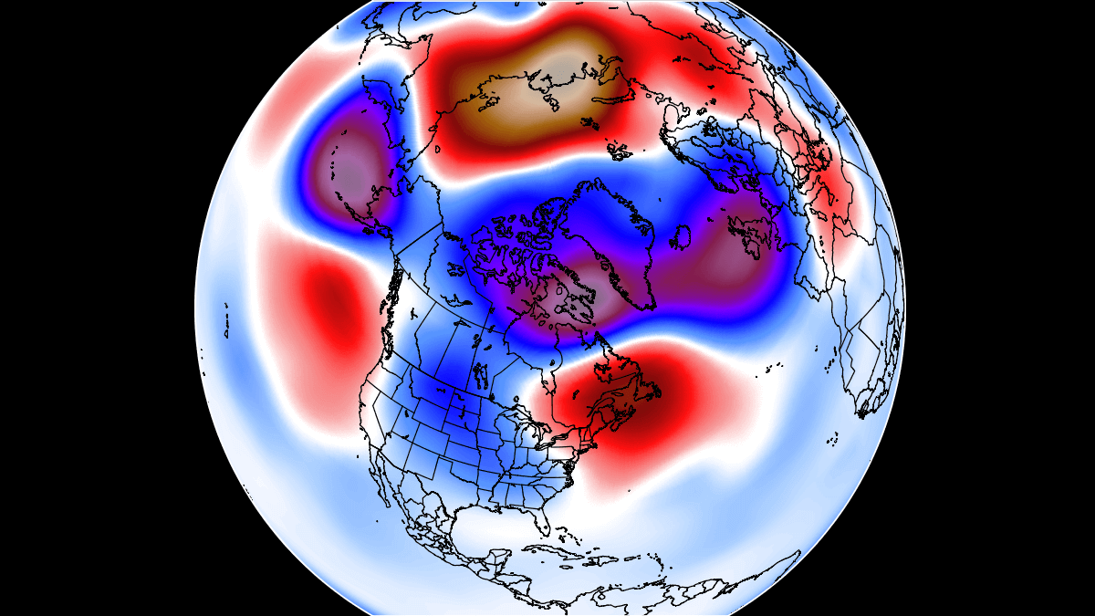
But what does a negative do to the atmosphere? Below we have a 40-year correlation between IOD and the 500mb geopotential height pattern in the winter season.
We can see a high-pressure area in the North Pacific and a low-pressure zone over Canada and the northern United States. This is somewhat similar to a negative ENSO pattern in the North Pacific.
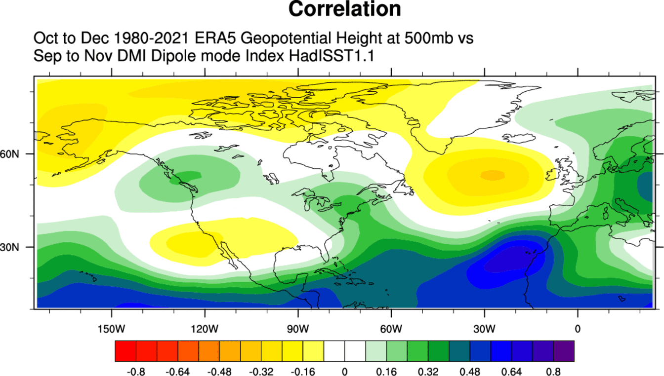
We can also see a high-pressure zone appearing in the North Atlantic, showing a more negative NAO setup. This pattern is close to negative PDO and ENSO (La Nina). Overall they all interfere with each other and together impact the cold season climate.
The negative IOD usually co-exists with a negative ENSO phase (La Nina). That means their historical pattern can look similar and supports each other in producing a stronger signal.
FALL 2022 LONG-RANGE FORECAST
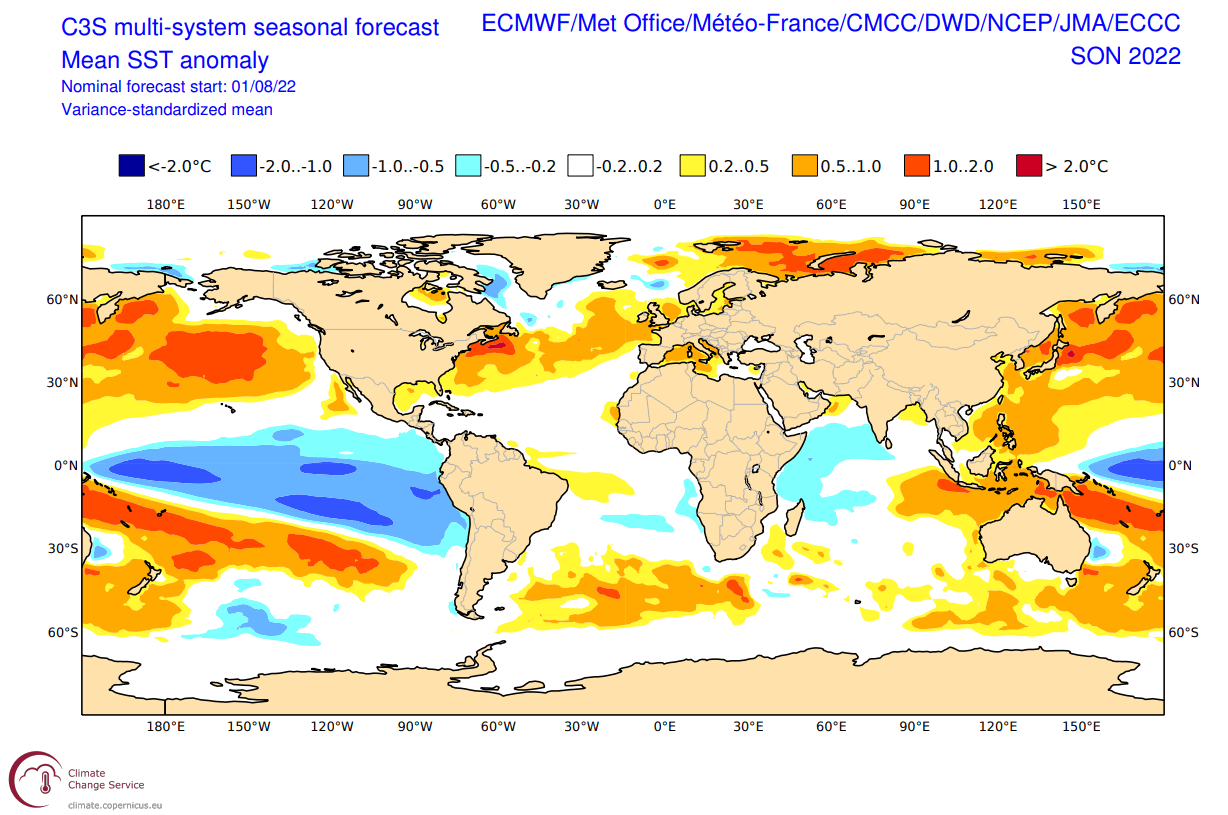
For the final Fall 2022 forecast, we focused on the two main (or most used) seasonal models. The ECMWF model from Europe and the CFSv2 from NOAA/NCEP in the United States. Graphics are from the Copernicus Climate EU project and the CPC/NCEP.
All these forecasts are an average picture over the course of 3 months (September-October-November) and show the prevailing weather pattern forecast for the meteorological Fall. This only shows/implies how the weather patterns might look 40-60% of the time during the weather season.
ECMWF FALL 2022 FORECAST UPDATE
Generally, the ECMWF model is at the top of the chart regarding reliability. But no long-range/seasonal forecast can ever be deemed “reliable.” We are only looking at trends and how the weather patterns might evolve on a large scale.
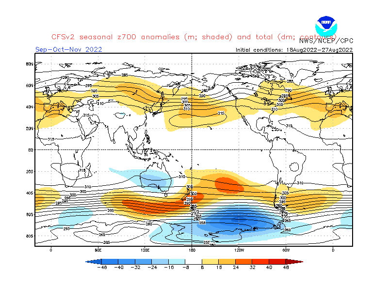
The forecast shows the signature La Nina high-pressure system in the North Pacific, with positive anomalies over the western United States and the North Atlantic. This is very similar to the historical analysis we have done above. It also has a low-pressure zone hinted over Alaska and western Canada.
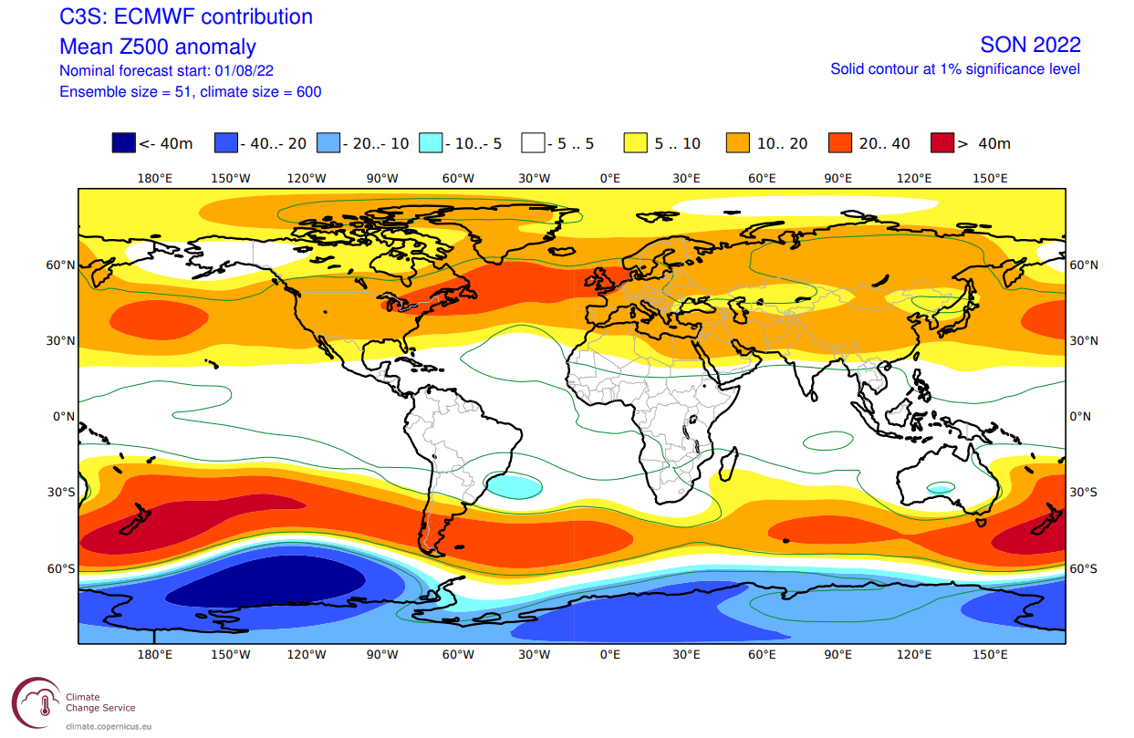
Looking at the European sector, we have a high-pressure zone extending from the Atlantic into Europe. As a response, the low-pressure zone is moved further up to the north.
When we look at the global air temperature anomaly distribution, we can see the warmer temperatures over much of the United States and northern Europe. The same goes for southern and eastern Canada.
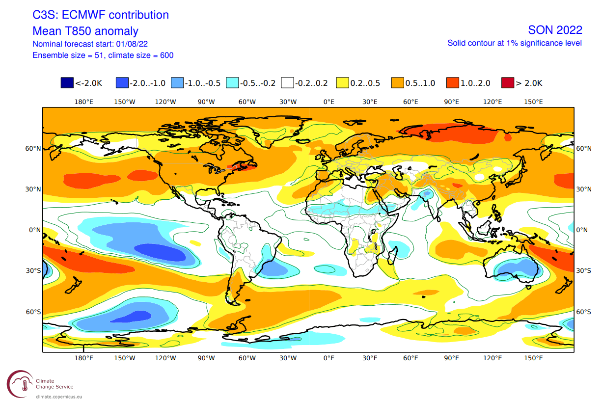
Weaker warm anomalies are hinted at across the far southern United States, as seen in the historical analysis as well. But, this seems to be quite a typical La Nina pattern overall, confirming its presence in jet stream circulation.
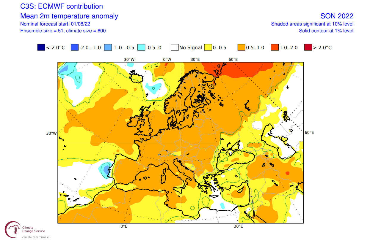
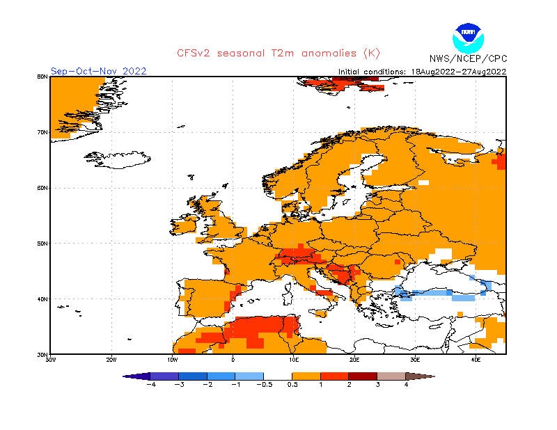
Looking closer at Europe, we can see warmer than normal surface temperatures over much of the continent. This is due to a high-pressure area over the North Atlantic and extending into Europe.
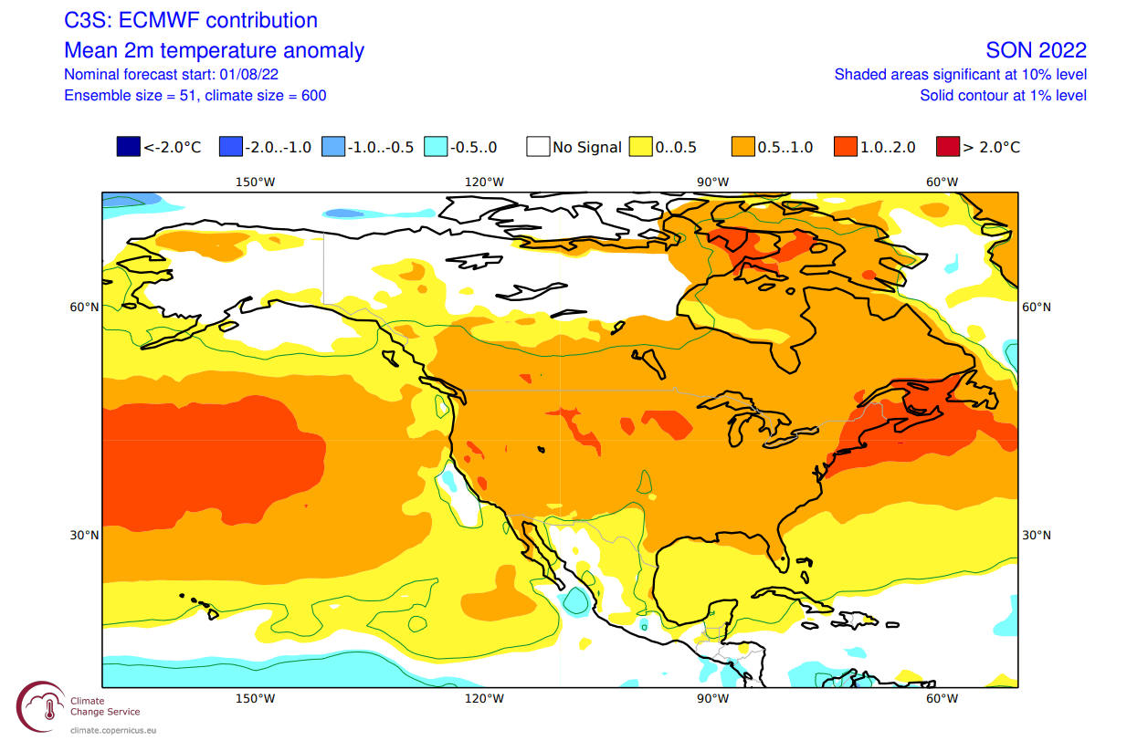
Over North America, we see warmer than normal temperatures under a high-pressure anomaly over the United States. Warm anomalies extend into the far northeastern United States and southern and eastern Canada. But Alaska and northwestern Canada remain neutral to cool under the influence of the returning polar jet stream.
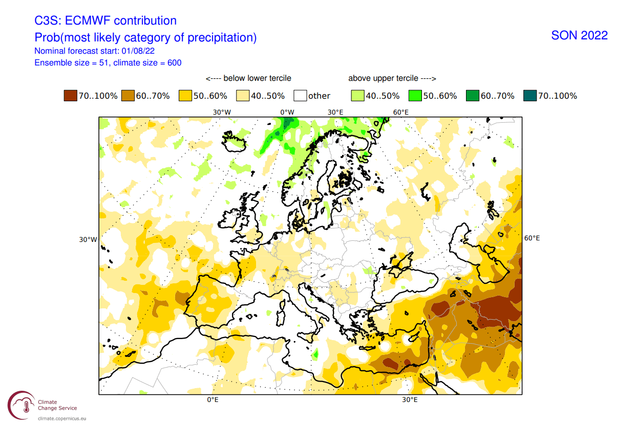
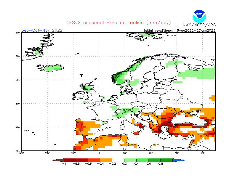
Precipitation-wise, we can see mostly drier conditions over Europe. More precipitation is forecast over northern Europe, under the influence of a nearby low-pressure zone.
Over North America, we have wetter conditions hinted over the western United States, also covering most of western and northeastern Canada. The Midwest and the eastern United States show a dry signal, along with southern Canada.

The precipitation pattern tends to reveal the path of low-pressure systems. This forecast shows a precipitation trail from the North Pacific into western Canada and northeastern Canada.
This tells us that the low-pressure systems will travel from North Pacific across the Pacific northwest into northeastern Canada.
CFS FALL 2022 FORECAST UPDATE
We also tend to use the main North American long-range model, the CFS version 2 from the NOAA/NCEP in the United States. We will use the latest forecast update from late August.
The CFS also has a proper La Nina developing over Autumn and into early Winter. Again, the intensity is similar to the ECMWF forecast, showing a moderate negative ENSO event.
The global pressure pattern has similar features to the ECMWF. High pressure is present over the central North Pacific and North Atlantic, belting over the United States. A low-pressure area is most likely over western Canada and Alaska, as in the historical pattern.
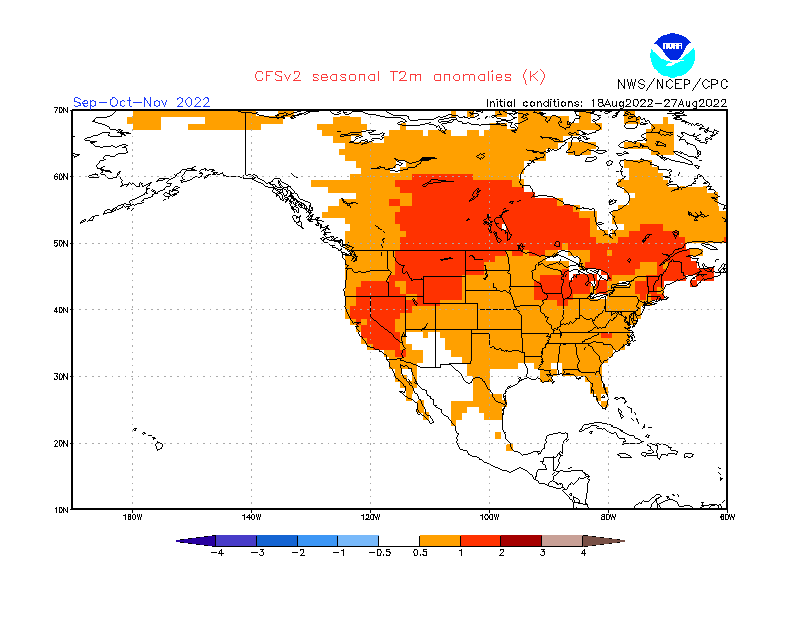
Temperature-wise, we have a clear warm signal over much of the northern United States and southern Canada. Most of far western Canada and Alaska are forecast as neutral, also hinted by the ECMWF. Warmer anomalies are also present over western and southern Europe.
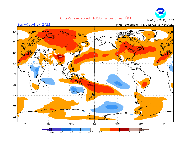
Looking closer at Europe, we see warmer temperatures over much of the continent. In addition, stronger warm anomalies are forecast for parts of central Europe.
But the pressure difference is more impactful in the precipitation forecast. We see normal to wetter conditions over central, northwestern, and northern Europe. At the same time, we have drier conditions over far southwestern and southeastern Europe.
Temperature anomalies over North America show warmer than normal Fall over western and northern United States. We also see most of Alaska and northwestern Canada with normal temperatures under a low-pressure area.
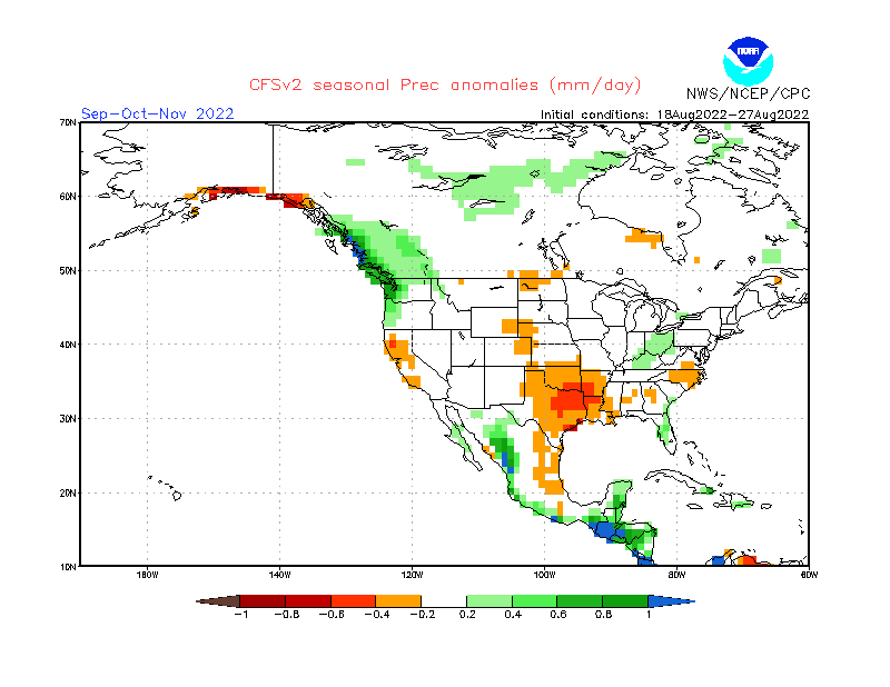
The more westerly flow also means wetter conditions for the Pacific Northwest, thanks to the low-pressure systems passing by. Drier conditions prevail over much of the central parts of the United States, influenced by the stable conditions of a high-pressure system. More precipitation is also seen over the Ohio River Valley.
FALL 2022 FINAL FORECAST SUMMARY
Reading images and descriptions can be confusing sometimes. So to summarize, here is what the model forecasts suggest for the Fall 2022 season:
Europe is expected to have warmer than average temperatures over most continents. A high-pressure system prevails in Autumn over much of western and central Europe.
Northern Europe will likely be under the influence of a low-pressure system, while weather over the British Isles will depend on the positioning of high pressure in the North Atlantic.
No big precipitation anomalies are expected over the mainland, except for likely drought conditions in Autumn over southern Europe and the Mediterranean. However, Scandinavia could see more precipitation in the Autumn season.
North America Fall forecast shows a high-pressure area is favored over the western United States and the far northeastern United States. A low-pressure is set to develop over western Canada and Alaska.
Most of the western and southwestern United States can expect to see warmer than normal and drier conditions. But the southeastern United States is expected to see a normal Fall, with a chance of more precipitation than normal over Florida.
Northern United states will likely see warmer temperatures and drier conditions over the Midwest. Later in the season, earlier snowfall can be expected over the upper Midwest as the pattern evolves toward the winter configuration with the La Nina influence growing.
Above normal temperatures are also expected over eastern Canada, while western Canada and Alaska should see normal to colder conditions and a higher chance of an earlier winter season.
The La Nina influence is expected to grow later in the season so that a low-pressure area will be further established over western Canada. This could mean early snowfall is also likely for parts of the northwestern United States.
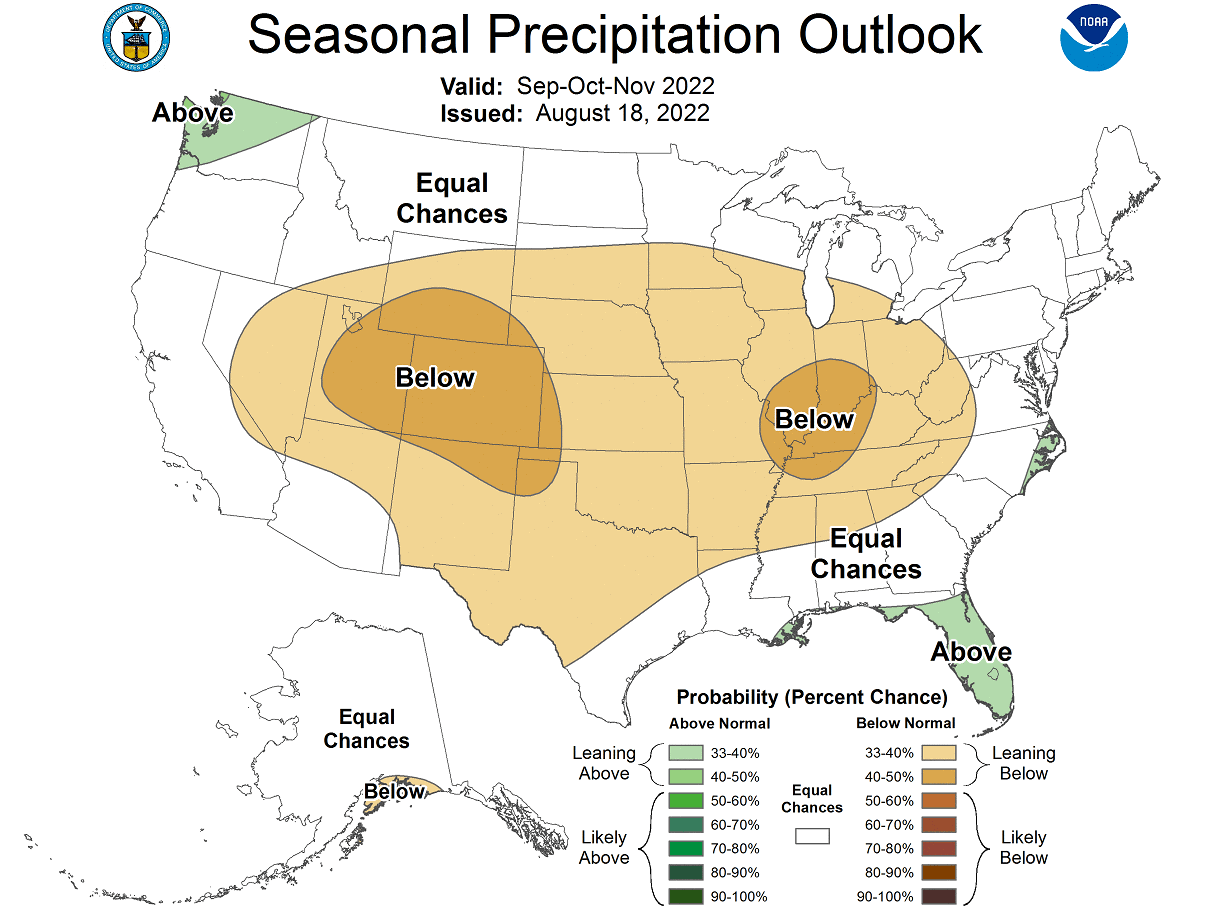
Below is the official Fall 2022 outlook from NOAA/CPC for the United States. Temperature-wise, we see the warm west and far northeast standing out.
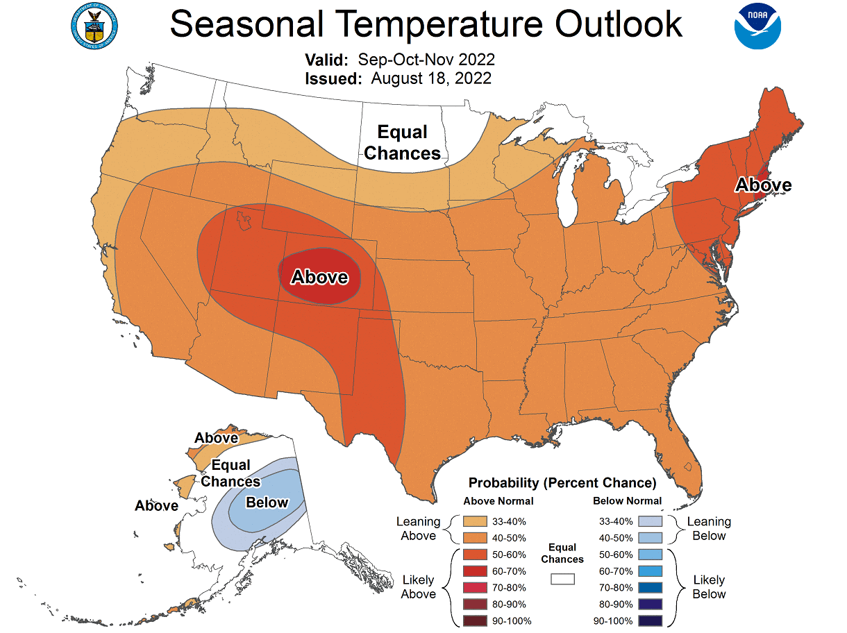
We can also see a neutral temperature zone in the upper Midwest. That does indicate a chance of more cold fronts coming down from the northwestern United States and western Canada towards the central regions. It could mean earlier snowfall than normal over the northern United States.
Precipitation-wise, the NOAA Fall 2022 outlook shows drier conditions in the western and central United States. Wetter conditions are expected mostly over the east coast of the United States and the Pacific Northwest.
The problem with precipitation in a La Nina winter is usually the persistence of drought conditions in the south and southwest. Below we have the latest drought graphic from NOAA, which shows the current drought conditions in the United States.
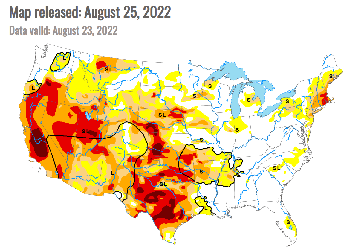
Strong drought conditions prevail over the south-central and western United States. We can see some recovery over the southwest, especially in Arizona. That is thanks to the summer monsoon bringing a decent amount of precipitation.
But the drought conditions in the south are expected to continue and can worsen in a La Nina Winter. The same goes for the southwest and parts of the western United States, like California.
There is no certainty in the long-range forecasts at this lead time. But one very important factor also appears in Fall and plays a role all the way into Spring. That is the Stratospheric Polar Vortex.
POLAR VORTEX RETURN
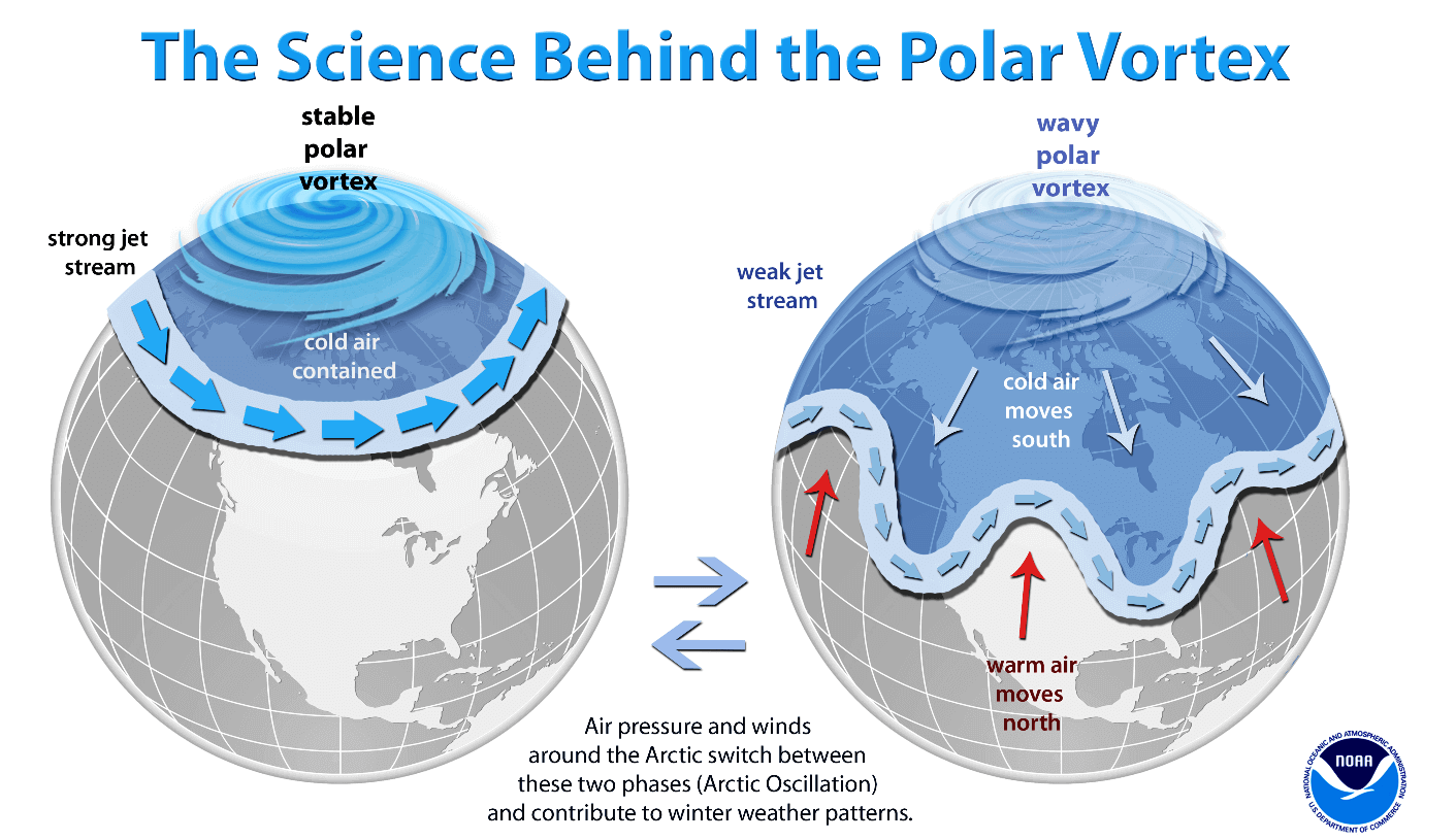
We cannot talk about Fall without also mentioning the Polar Vortex. The Polar Vortex re-emerges every Fall and plays a very important role in weather development in late Fall, over the Winter, and into Spring.
The Polar Vortex is a large cyclonic area that is spinning over the entire Northern Hemisphere, from the ground up to the top of the stratosphere, reaching over 50km/31miles in altitude.
We produced a 3-dimensional model of the Polar Vortex, extending from the lower levels up into the stratosphere. The vertical axis is greatly enhanced for better visual purposes. You can see in the image below what the actual structure of the Polar Vortex looks like.

In the example above, the Polar Vortex underwent a temporary warming event. These events can disrupt the Polar Vortex, weakening its circulation and changing the weather patterns below.
A strong Polar Vortex usually means strong polar circulation. This usually locks the colder air into the Polar regions, resulting in milder seasonal conditions for most of the United States and Europe.
In contrast, a weak Polar Vortex can create a disrupted jet stream pattern. As a result, it has a harder time containing the cold air, which can now escape from the polar regions into the United States or Europe.
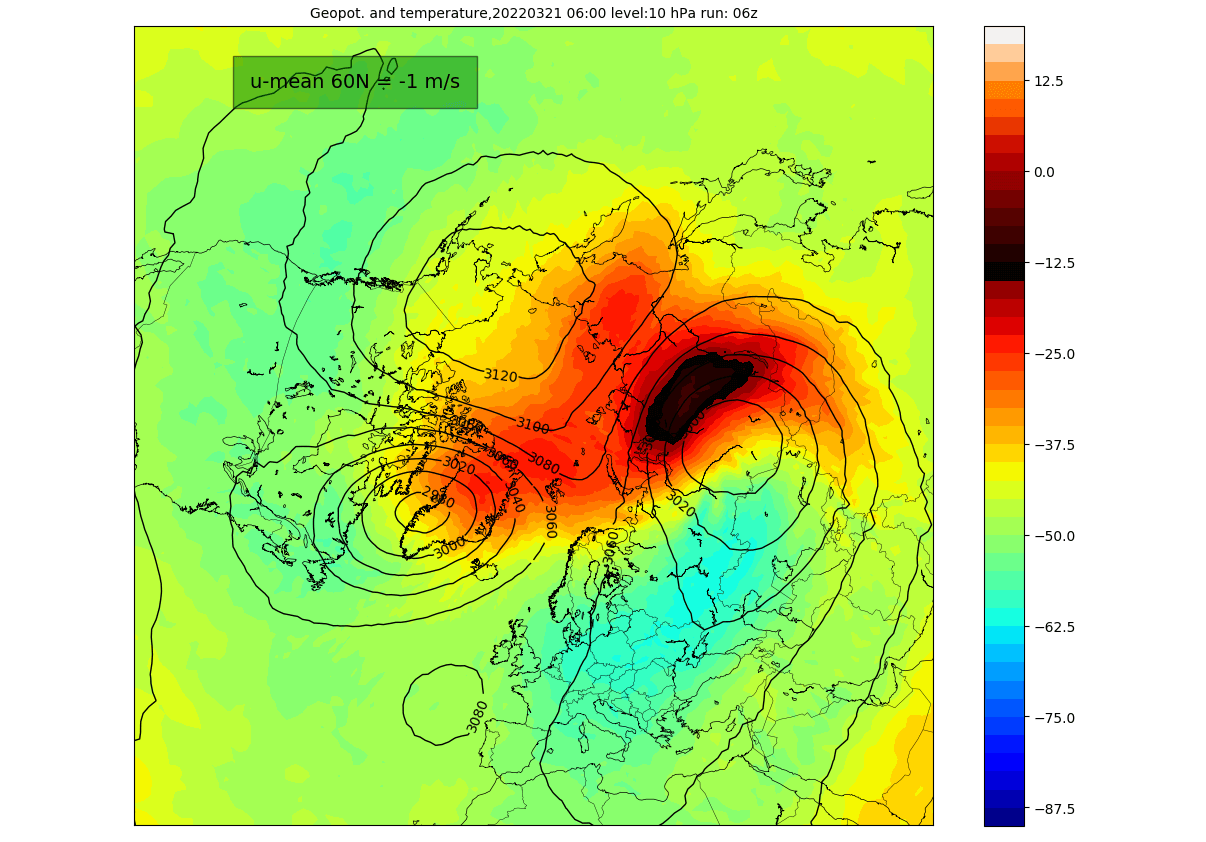
The most recent stratospheric warming event actually occurred this year, in late March. It was strong enough to influence the early Spring pressure patterns over the Northern Hemisphere.
Looking at the temperature profile at the 10mb level (30km/18.5mi), we can see a warming wave developing over eastern Siberia in late March. Here we can also see the separation of the core into two separate entities, as a stratospheric high-pressure system was pushing in from the North Pacific.
The image below shows the vertical pressure anomaly from the surface up into the upper stratosphere over the North Pole. It gives us a better idea of the pressure anomalies changing with time and altitude. The red square marks the polar vortex collapse event.
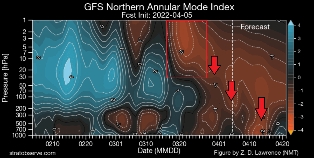
We can see by the arrows that the high-pressure anomaly resulting from the warming event was propagating down. It then connected to weather patterns in late March and early April.
We have an interesting picture now of the forecast for the upcoming seasons. The ECMWF forecast for the 10mb stratospheric zonal winds shows a reduction in the power of the stratospheric winds in late Fall and early Winter.
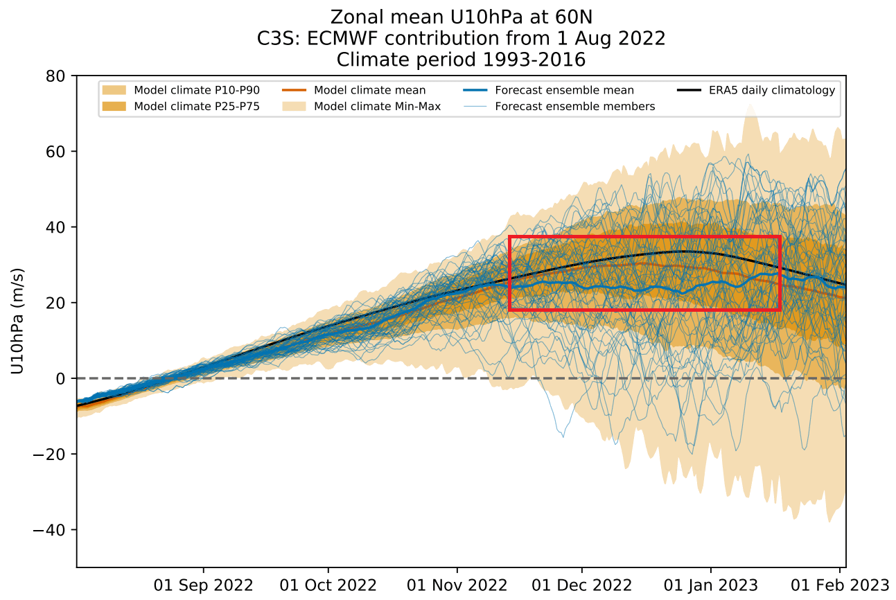
As winds are directly related to the strength of the Polar Vortex, we can see this as a signal for a weakening of the Polar Vortex. This would imply a more disrupted pattern and a chance of high-latitude blocking, thus more cold air in the United States and Europe.
It gives us a signal to keep an eye on, as these dynamics can have a large-scale and long-lasting impact on the weather pattern during Winter.
We will keep you updated on the global weather pattern development for the coming seasons, so make sure to bookmark our page. Also, if you have seen this article in the Google App (Discover) feed, click the like button (♥) there to see more of our forecasts and our latest articles on weather and nature in general.
SEE ALSO: