Dramatic winter weather conditions are forecast across western Europe into Scandinavia from Sunday into Tuesday, thanks to a deep winter storm crossing Ireland and the UK while rapidly strengthening. Significant snowstorms with deep snow accumulations are forecast across Ireland to the northern UK on Sunday. Monday will bring more heavy snow blizzards into southern Norway as the cyclone intensies over the North Sea Sunday night.
The new year continues with dynamic and progressive weather patterns across the North Atlantic and Europe. Thus, more winter storms are forecasted to graze the continent in the coming days.
We are tracking the first storm, which will blast into Ireland and the UK on Sunday and then move into Scandinavia on Monday.
Heavy snowfall is forecast to occur along the strengthening Atlantic storm as it moves across Ireland early Sunday morning. During the day, it will continue northeast across north-central England.
Then, over the North Sea, the cyclone intensifies further before blasting southern Norway and Sweden with a heavy snow blizzard on Monday.
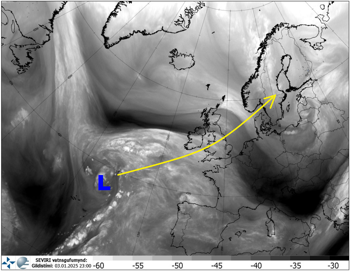
Early this Saturday, a water vapor satellite image across the Atlantic indicated a developing storm north of the Azores. The storm gradually organized into an extensive system while accelerating toward Western Europe.
The storm will track northeast across southern Ireland and central England on Sunday, reach the North Sea on Monday, and mature over southern Scandinavia on Tuesday.
The attached video represents a quick overview of the rapidly deteriorating winter storm conditions across western and northern Europe from Saturday into Tuesday.
A sharp temperature gradient will bring snow to the northern side of the frontal boundary and heavy rain to its south. Strong warm advection results in heavy precipitation.
Heavy snow will develop across southern Ireland, Wales, and north-central England on Saturday night and continue on Sunday.
The winter storm will track into the North Sea by Monday.
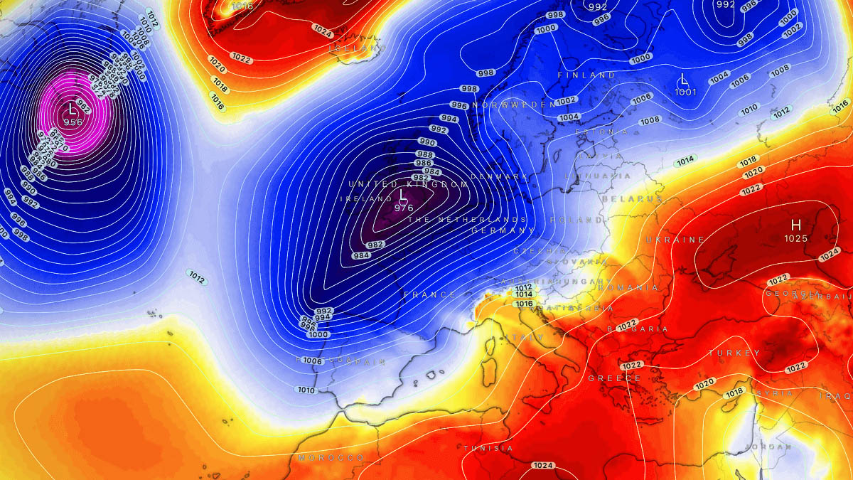
Deep trough emerges into western Europe on Sunday, winter storm blasts across Ireland and UK
The general weather picture across Europe on Sunday indicates a deep upper-level wave emerging from the Atlantic into Western Europe, paired with a blocking High over southern and eastern Europe. This will allow strong surface frontogenesis and form a significant winter storm over the UK.
The strength of the High further east over the continent will drag the disturbance towards Scandinavia early next week.

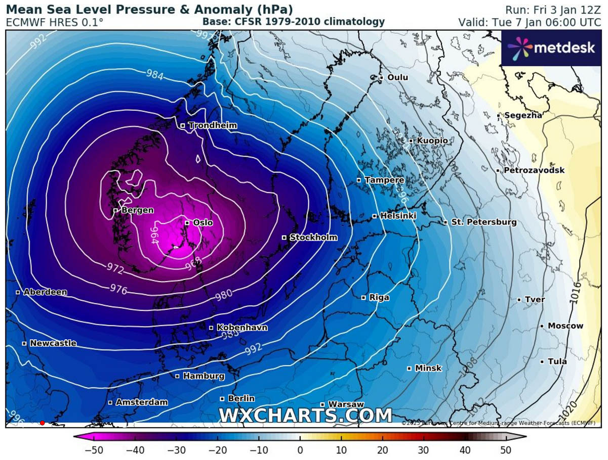
This is a significant disturbance in the upper levels, leading to a strong winter storm. The central pressure will continuously fall while the system crosses the UK, from the mid-980s Saturday night into the low-960s over the North Sea on Monday.
The rapidly deepening low will pump vast amounts of moisture from the southwest toward the surface frontal system and simultaneously bring a much colder air mass from the north. This will result in heavy precipitation, snow in the north, and rain in the south.

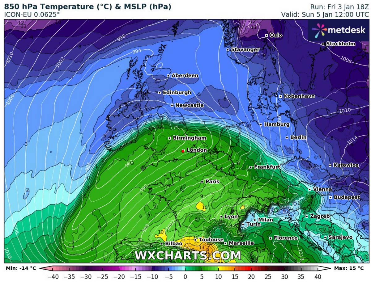
The following 850 mbar (approximately 1250m above sea level) temperature chart represents a sharp temperature gradient along the frontal zone, stretching from southern Ireland across central England to the Netherlands on Sunday afternoon.
Strong, warm advection is seen south of the front, while a cold air mass remains north of the system’s core. This will support heavy winter precipitation and could temporarily bring freezing rain besides the heavy snow.
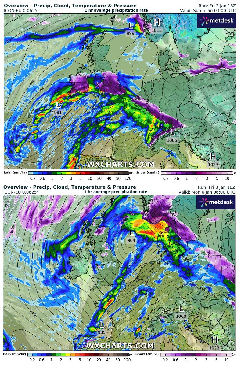
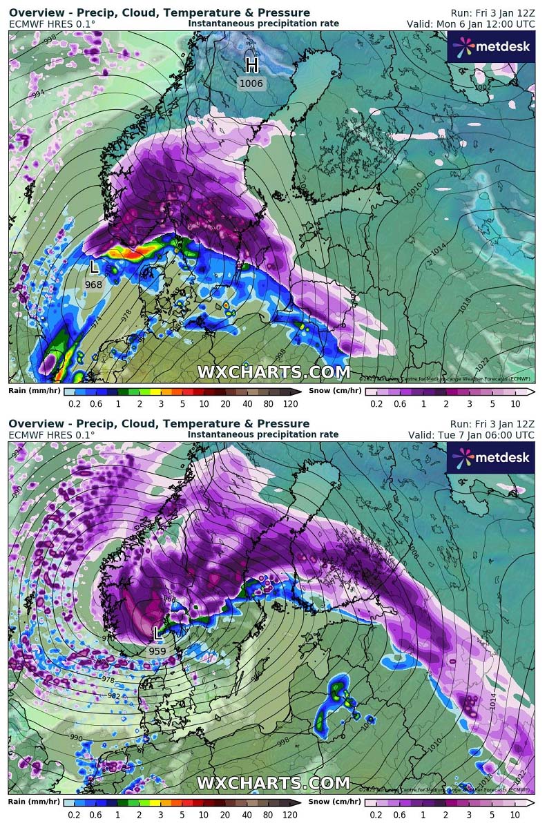
The Atlantic storm will continue deepening its central pressure as it emerges into Ireland and the UK on Saturday night. Heavy snow will develop north of the warm front. Southern England will see heavy rain, as warmer air mass advection will be strong.
The cyclone will quickly move northeast into the North Sea, reaching southern Norway and Denmark by Monday morning. Heavy snow will spread into Norway and Sweden, while heavy rain will occur over Denmark and coastal areas of south Scandinavia.
Freezing rain will locally be possible where the cold pool will remain trapped.
The highest amounts of snow across western Europe are forecast to accumulate to the immediate north of the frontal boundary and storm’s core. The latest model guidance agrees that south-central Ireland, parts of Wales, and north-central England will see the highest amounts.
A combination of substantial air mass frontal forcing with enough cold temperatures will lead to heavy, wet snow. Some areas could see 10-30 cm of fresh snow within 24 hours. Even more snow is likely in higher elevations of Wales and northern England. Southern Scotland should also expect deep snow accumulation on Sunday.
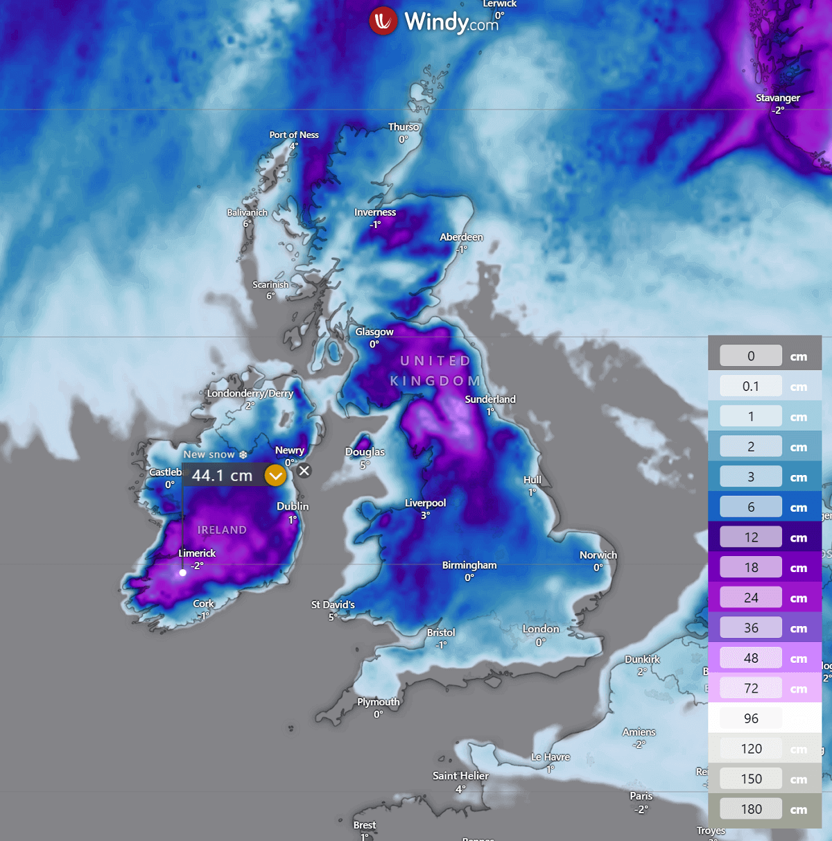
Overall precipitation during the winter storm will be high across southern Ireland and central England. By Tuesday morning, 70-120 mm will locally be possible.
This could worsen the ongoing soaked ground locally and lead to additional flooding in some areas.

Snowfall over Ireland and the UK will gradually vanish Sunday night into Monday morning as the system tracks into the North Sea.
Cold maritime air mass will spread behind the low, therefore wintry showers are expected across the UK and Ireland on Monday.
Another intense storm with heavy snow blizzard for Norway and Sweden on Monday
Thanks to a blocking ridge over Eastern Europe, the deep wave over Western Europe tracks into Scandinavia early next week. A deep core will be parked over Norway and Sweden on Monday and Tuesday.

This will support further strengthening of the UK winter storm as it tracks across the North Sea, rapidly deepening its central pressure into low 960s mbar by Monday night as the system reaches southern Norway.
Strong warm advection will bring heavy precipitation, mostly heavy snow, and strong to severe winds to its north.
Through Monday morning, heavy snow will spread across south-central Norway and central Sweden, while extreme southern Sweden and Denmark will already change from snow to rain due to a much warmer air mass arriving with the low.
To the north of the stalled surface low, heavy snow blizzard is expected to continue throughout Monday and Monday night across most of southern Norway and central Sweden. A snow band along the front will also spread across south Finland on Monday night.
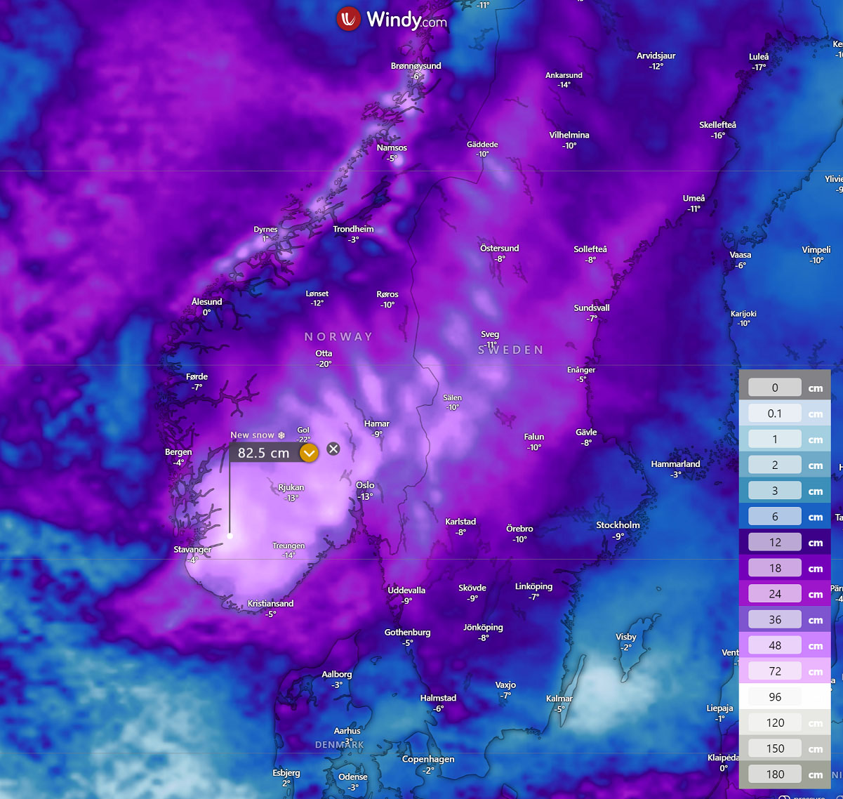
While most of Norway is already experiencing heavy snowfall this winter, this system is expected to bring additional abundant snow.
The highest amounts of snow are forecasted to accumulate across southern Norway and central Sweden. Locally, 40-80 cm of fresh snow will be possible in about 36 hours from Monday morning through Tuesday evening.
Avalanche risk will significantly increase.
Heavy snow will spread northeast across Norway, Sweden, and Finland on Tuesday while the system gradually diminishes.
Dynamic weather with wintry conditions and snow events will likely continue in the coming weeks, and progressive patterns across the North Atlantic and Europe are forecast to remain.
Stay alert for dangerous driving conditions on Sunday, when a winter storm will affect Ireland and the UK. On Monday, a heavy snow blizzard will affect Norway.
Wxcharts, Windy, and Pivotalweather provided images used in this article.
See also: