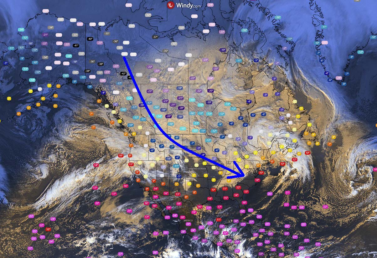
January 2025 starts with a progressive weather pattern across North America. A huge reservoir of Arctic cold air mass has accumulated over Canada and will spread south into the United States in the coming days. First, a major winter storm, Blair, will bring deep snow and ice storms from the Plains to the East Coast Sunday into Monday, followed by an intense Arctic cold outbreak next week.
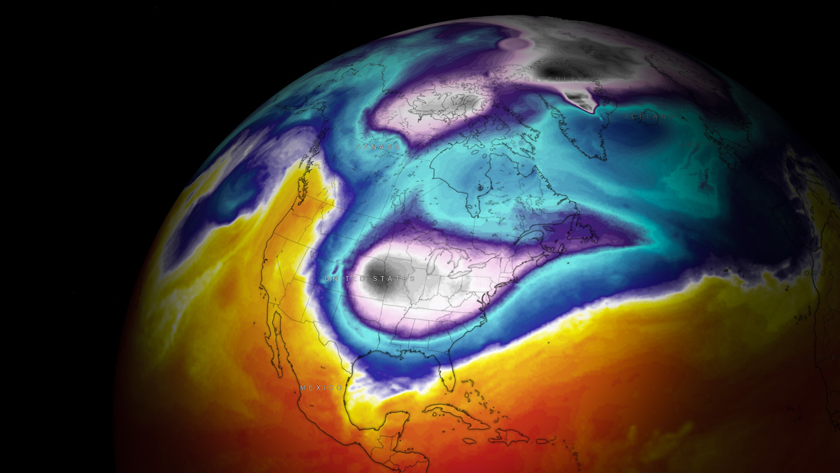
The new year continues with the disturbance of the Polar Vortex aloft. Its southern lobe is forecast to dig deep south across the North American continent, dragging significantly colder air mass from Arctic Canada towards the eastern half of the United States. The frigid cold will also reach the Gulf Coast next week.
The first change in the weather pattern will be a major winter storm Blair, which is expected to occur on Sunday. The storm is forecast to spread deep snow and ice storms from the central Great Plains across the Mississippi and Ohio Valley to the East Coast through Monday.
Accompanied by strong winds, the blowing snow will reduce visibility and make travel difficult. Snow blizzards and whiteout conditions along the storm’s path will be possible. Conditions will deteriorate rapidly from Sunday morning into Monday as the winter storm intensifies and tracks eastward.
The current weather picture across North America reveals an impressive Arctic cold air mass reservoir accumulating over Alaska and Canada, gradually turning towards the south. Temperatures are below -40 °C / °F in Northern Canada.
The attached video represents a quick overview of the rapidly deteriorating winter storm conditions across the Great Plains towards the East Coast on Sunday.
This will be followed by an intense Arctic cold outbreak from Canada into a large part of the Contiguous U.S. throughout next week.
Before we discuss the evolution of winter storm Blair over the weekend and the frigid cold next week in more depth, let’s have a quick overview of the Polar Vortex. The Polar Vortex is often responsible for significant winter weather events in the northern hemisphere, so it is essential to know about it when we track our daily weather.
What is the Polar Vortex?
The Earth’s atmosphere is built of six layers rounding our planet. The majority of the dynamics for our daily weather occur in the lowest two layers. Those two are known as the troposphere and the stratosphere layers.
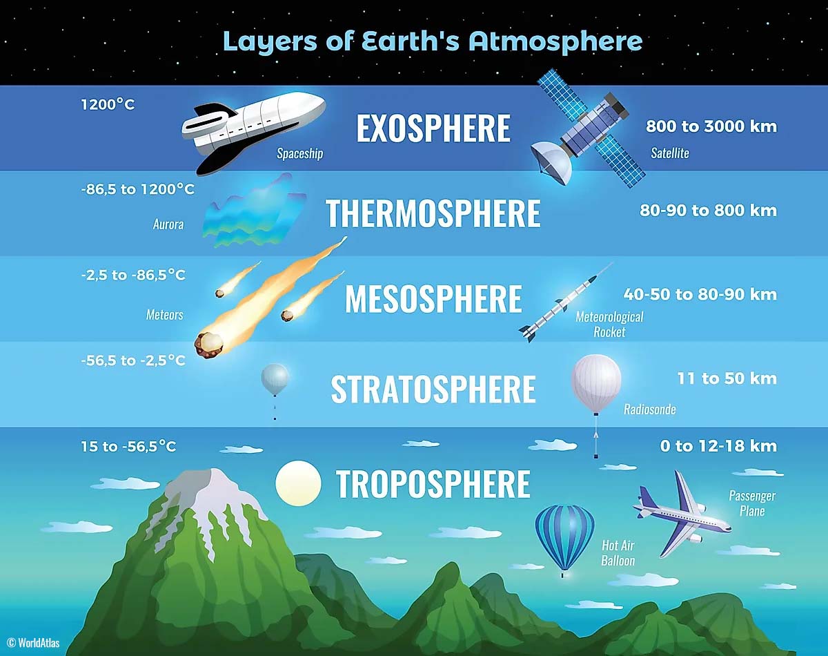
The troposphere is the layer closest to the Earth’s surface. It is about 12 km deep and extends from the ground up high into the sky. Depending on where you live, the troposphere’s depth varies from around 8 km to almost 20 km. The troposphere is the deepest above the equatorial region but gets much thinner above the North and South poles.
Above this layer is a much deeper one known as the Stratosphere. It is an 11-50 km thick layer with very dry air. The stratosphere also has the Ozone layer, which is vital in protecting our planet’s life against the potential solar storm impacts from the Sun or outer space.

Another essential feature in the stratosphere, which makes our weather even more variable, often triggers significant large-scale weather events. This is the Polar Vortex, an enormous, tri-dimensional ring of powerful winds moving through the sky above us. The Polar Vortex is spinning around the North Pole, grazing through the air at about 20-50 km above the Earth’s surface with violent wind speed.
The troposphere and the stratosphere are crucial for our climate, as the Polar Vortex covers most of the bottom half of the atmosphere. Since the vortex extends from the middle of Earth’s troposphere up into the stratosphere layer, it has a major effect on winter weather across high and mid-latitudes yearly.

We could experience this in Canada, the U.S., and recently in northern Europe and Asia as the vortex has been disrupted and shifted on the other side of the north hemisphere.
The Polar Vortex is most substantial during winter in the Northern and Southern Hemispheres. Although it spins well above our heads, it remains closely connected with the lowest parts of our atmosphere. Thus, it influences our daily weather in many ways, as it generally functions as one sizeable hemispheric circulation.

The Polar Vortex above us has triggered all the dynamic weather systems, from the frigid cold outbreaks and winter storms in Canada and the United States to the lack of winter weather and snow in other parts of the northern hemisphere.
How and when the Polar Vortex forms?
During the fall months, the polar regions receive much less energy from the Sun. This causes the cooling over the northern areas to become more robust. As a result, polar nights occur for several consecutive months, followed by days without sunlight.

While the temperatures in the polar region are dropping into a deep freeze, the atmosphere layers farther to the south are still relatively warm, as they receive more of the sun’s energy simultaneously. Therefore, the south’s equatorial layers remain much warmer than the areas farther north, leading to a high-temperature contrast.
Cooling the polar regions also lowers the ambient surface pressure, with a similar weather process also happening in the stratosphere layer. Therefore, the temperature difference between the North Pole and the equatorial areas increases across both layers. This creates a large low-pressure cyclonic circulation across the polar stratosphere, where this feature became famous – the Polar Vortex.

Putting all these puzzle pieces together, the Polar Vortex is an enormous cyclone in our atmosphere. During winter, it expands across the North Pole and sometimes becomes very intense, extending south to the mid-latitude regions. The same is also happening in the southern hemisphere during winter, as the Polar Vortex intensifies around the South Pole.
The weather model chart above hints at a typical situation of the Polar Vortex fully established above us. It represents the pressure at around 30 km (18 miles) altitude, near the top of the stratosphere layer during winter.
The active and strong Polar Vortex during the start of the Winter season 2024/25 has been the main trigger behind the recent frigid cold outbreaks over Siberia, where temperatures below -55 °C have been observed.
Recently, the most intense part of the vortex, its southern lobe, has gradually been shifting and strengthening over the North American side of the northern hemisphere.
Major Winter Storm with heavy snow, ice, and blizzard from Plains across Ohio Valley to East Coast on Sunday
In the coming days, the general weather picture across North America indicates an upper-level wave emerging over the Pacific Northwest on Saturday, moving into the central U.S. by Sunday, and deepening.
By early Sunday, the wave gradually develops a winter storm Blair over the central Great Plains, tracking east across the Mississippi and Ohio Valley towards the East Coast by Monday.

This is a significant disturbance in the upper levels, leading to a major winter storm. The low will pump vast amounts of moisture from the Gulf toward the surface frontal system, bringing a much colder air mass from the northern Plains and Rockies. This will result in heavy precipitation.
A surface depression will form over Oklahoma and Kansas early Sunday, bringing heavy snow to eastern Kansas Sunday morning. The storm intensifies throughout the day and tracks eastward Sunday night. Heavy snow, blowing snow, and difficult travel conditions will develop.

Heavy rain will develop across the south, with wintry conditions further north along the center of the surface low tracking east across Mississippi and Ohio Valley Sunday through Sunday night.
Severe thunderstorms will also be possible across the southern states, while the most significant concern is the high potential for freezing rain along the warm front.

A thick layer of freezing rain is forecast to spread from southern Missouri to extreme south Illinois and across Kentucky from Sunday morning through early Monday morning.
A swath of 0.5 – 1″ of ice thickness is locally possible, potentially leading to widespread power outages and tree damage along the storm Blair’s path.

Once the cold from the storm’s wake overspreads the region, heavy snow will take place and continue through Monday as the storm tracks towards the East Coast.
Around 8-12″ of snow is forecast along the swath from central Kansas across northern Missouri to central Illinois and Indiana, southern Ohio, and northern Kentucky to the East Coast. Some areas could receive more than 15 inches of snow by Monday, especially along the Appalachians.
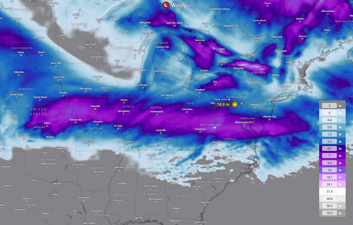
Washington, D.C., is also forecast to receive deep snow, with around 10 inches of fresh snow by Monday afternoon.
The most significant snowfall will be along the northern edge of the strengthening surface low as it tracks east. Blizzard conditions will develop with strong to severe winds in sharp pressure and temperature contrast. Significantly reducing visibility with whiteout conditions is likely to be expected.
Roads within the narrow swath of deep snow may become impassable, with significant travel disruptions on Sunday into Monday morning.
Significantly colder air mass spreads behind the winter storm Blair early next week, temps 30 degrees below normal
Winter Storm Blair ejects the East Coast onto the Atlantic late Monday, while a major cold air mass outbreak will occur from Canada into the northern U.S. on Sunday. Rapidly spread south and east through Monday and mid-week.
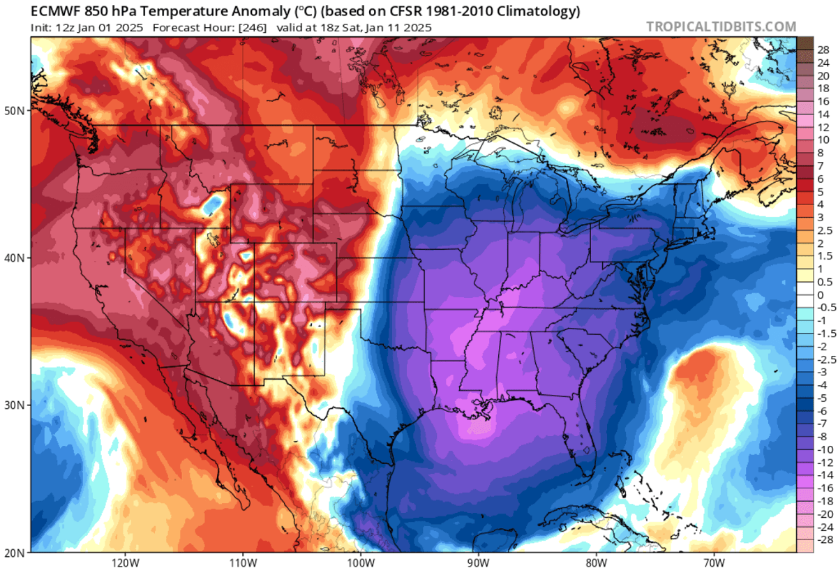
A frigid pool of Arctic air mass will overspread the eastern two-thirds of the Contiguous U.S., with the most significant temperature anomaly expected from central Plains across the Missisippi and Ohio Valley to the East Coast and aligned with the swath of fresh snow left from the winter storm Blair.
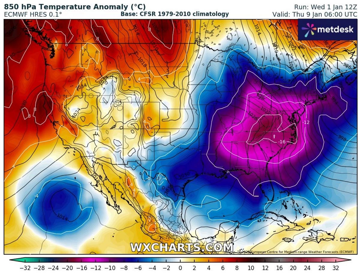
On Tuesday, morning temperatures across the Midwest and Northern Plains will plunge to -5 to -10 °F. Similar conditions will occur across Illinois, Indiana, and Ohio on Wednesday and Thursday.
Near or below-freezing temperatures will also reach the deep southern States, including the Gulf Coast from Louisiana to central Florida, by mid-week.

This means temperatures will be extremely low for these states, 20 to 30 degrees below normal from the central Plains across the Mississippi and Ohio Valley from Tuesday through Thursday next week.
Temperatures along the Gulf Coast will also be 10 to 20 °F colder than usual. The following two charts (upper: Tuesday, bottom: Thursday) hint at how intense, anomalous and extensive the cold pool is forecast behind the winter storm Blair.

Conditions will temporarily improve from west to east after Thursday, but additional cold will likely follow later.
Trends: Frigid cold air mass may extend through mid-January
There is a high potential that more winter storms could follow through mid-January, along with additional Arctic cold outbreaks. The NOAA outlook hints that the eastern United States will remain much below normal until January 15th, based on the fresh forecast from this Wednesday.

This perfectly aligns with the general weather model consensus that the pattern will establish a significant blocking High over the North Pacific and western CONUS. At the same time, significantly deep troughs would follow across the eastern U.S.
This classic “Polar Express” weather pattern indicates continuous waves of frigid cold Arctic air mass spread from Canada into the U.S. The 500 mbar forecast anomaly for Saturday next weekend is extreme.

The upper-level winds forecast indicates this locked-in pattern well. A powerful polar jet stream is rounding the Pacific High, resulting in meridional northerly flow into the U.S.
Then, turning around the deep low across the Southeast U.S., establishing intense winds high in the atmosphere.

Underneath the changing pattern, the surface high-pressure systems spread from Canada into the U.S. from mid-next week into the weekend. This is a classic occurrence with Arctic cold outbreaks, pushing surface pressure into the 1040 to 1050 mbar range or even higher.
As we can see from the chart below, high pressure will dominate most of the Contiguous United States.

The most extreme temperature anomalies will be aligned with the position of the upper wave, so they will most likely occur across the central and eastern U.S., the south, and the Gulf Coast.
How intense and where the most frigid conditions will occur is still a bit uncertain due to the forecast being nearly 10 days ahead, but general weather model consensus is in good agreement that Arctic cold will continue well into mid-January.
Proper wintry conditions with snow and extreme cold will likely continue in the coming weeks.
Stay alert for the dangerous weather conditions associated with winter storm Blair, followed by the most significant Arctic air mass of the winter season 2024/25 across North America.
Wxcharts, Windy, Tropical Tidbits, and Pivotalweather, provided images for use in this article.
See also: