We are tracking another significant winter storm, Cora, that will blanket parts of Texas on Friday, then head east across the southern states to the East Coast through Saturday. Some icy conditions are also expected from Texas to Virginia. The storm will impact major cities Dallas-Ft. Worth, Little Rock, Memphis, and Atlanta.
Behind the recent Winter Storm Blair, an Arctic outbreak air mass has engulfed a large part of the Contiguous U.S. and spread into the deep South, reaching the southwestern U.S., Texas, and Mexico. Thus, it established a solid cold pool across the region.
At the same time, a large upper wave is moving across the desert Southwest and is forecast to track east across the southern U.S. in the coming days. By early Friday, the wave will develop a surface low over Texas and become a Winter Storm Cora. It will be the main focus for significant winter weather through Friday and Saturday.
A swath of deep snow is forecast to blanket millions from Texas across the lower Mississippi Valley to the Appalachians on Friday into early Saturday. Icy road conditions could also be possible.

Below, Tuesday’s satellite analysis reveals a sizeable upper wave parked over the southwestern U.S., with a broad Arctic air mass cold pool dominating much of the United States and Canada on the surface.
The arctic air mass is forecast to maintain these cold temperatures throughout the week while the western wave gradually moves into the southern U.S. by Friday. And develop the winter storm.

The animation below provides a quick overview of the upcoming winter weather across the southern US from late Thursday through Sunday. A snowstorm will be moving from Texas to Virginia.
The cold air mass is spread behind the frontal system, further engulfing deep south Texas, including the western Gulf Coast and Mexico.
There has already been a winter storm watch for the threat of snow, sleet, and freezing rain in parts of northern Texas, southeast Oklahoma, Arkansas, and northern Louisiana, related to storm Cora. These include Dallas-Ft. Worth, Little Rock, Shreveport, and Memphis.
Let’s discuss the ongoing weather pattern and evolution of the potential significant winter storm for the upcoming weekend.
An upper wave emerges into the Southern Plains, develops a Winter Storm Cora
The upper wave, currently over the West Coast and desert Southwest U.S., will gradually move east across Arizona and New Mexico to Texas by Friday morning and deepen.
Underneath the wave, the surface low will intensify into a frontal system, resulting in a Winter Storm (it was named Cora by the Weather Channel).

The upper wave will first be nearly a closed low over northern Mexico and western Texas and become an elongated trough on Friday. This will accelerate the storm’s northeastern from Texas into the Mississippi Valley and Southeast states.
The deep wave and surface low will push the Arctic cold air mass further south across the southwestern U.S., reaching central Mexico and western and north-central Texas. Thus, it induces chilly temperatures, allowing rain to change to snow as Cora progresses across Texas on Friday.
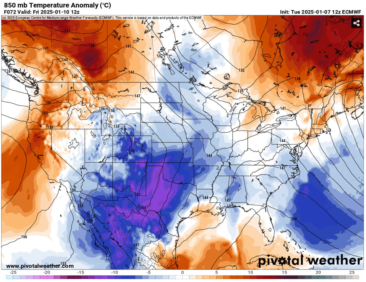
Strong temperature anomalies will support heavy wintry precipitation in the areas beneath.
Deep snow cover from northern Texas across the lower Mississippi Valley is forecast
By Friday morning, winter weather will occur across West and North Texas, southern Oklahoma, and Arkansas. Heavy snow will develop. This includes Dallas-Ft. Worth, Little Rock, and Shreveport.
Heavy rain will continue South of the freezing line, most intense across East Texas and Louisiana in the morning and later on further east across Mississippi, Alabama, and Georgia. Heavy rain, including some severe storms, will spread along the Gulf Coast from Texas to the Florida Panhandle.
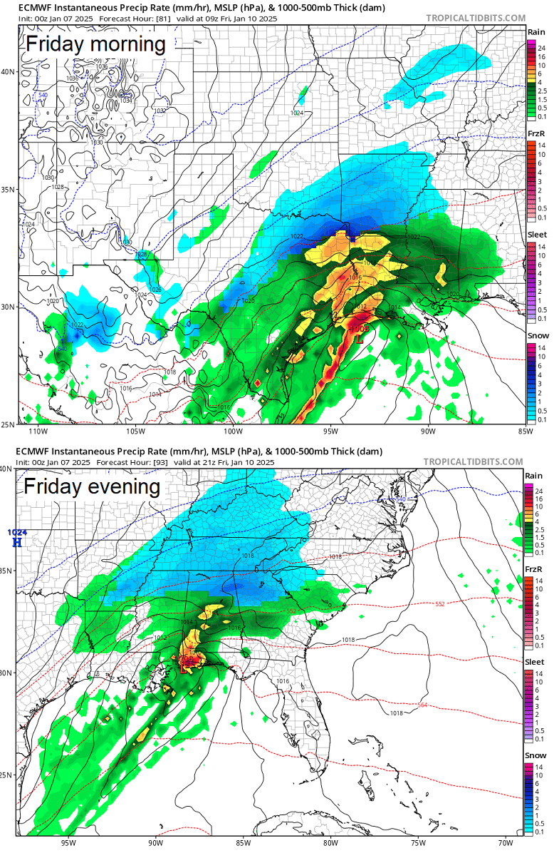
According to the general high-resolution weather model consensus, there are good chances for snow in northern Missisippi, Alabama, and Georgia, including Atlanta.
A narrow corridor between the heavy rain and snow will also support sleet, freezing rain, and icy roads due to strong warm air mass advection aloft, while lower layers temperatures will be below freezing.
This will most likely form from central Texas across southern Arkansas to northern Mississippi. Up to 0.5″ of black ice could accumulate in part of Texas early Friday.

The latest weather model forecast suggests a swath of deep snow is expected from central Texas across central Arkansas to Tennessee. 8-14″ will likely accumulate in less than 24 hours as storm tracks across the southern states. Up to 10″ of snow will be possible over Dallas-Ft. Worth, TX, area has a similar amount of snow to Little Rock, AR.
A couple of inches of snow is forecast across Oklahoma, with up to 10″ in the far southeast part of the state. 3-8″ are expected surrounding the narrow, deep snow swath across Missouri, southern Illinois, Indiana, Ohio, and Kentucky.
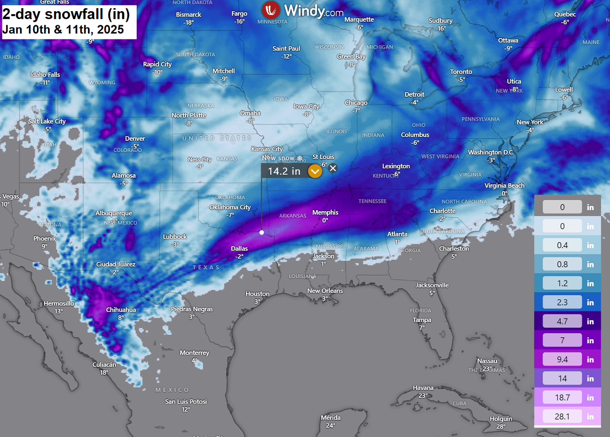
Northern Mississippi and Alabama could also see snow from 4-10″ on Friday. Snow amounts will diminish towards the East Coast as winter storms vanish with time towards Saturday morning.
Heavy rain will spread along the Gulf Coast further south, with 2-4 inches expected from the Texas coast to southern Alabama. The highest amounts of rain are forecast from Houston, TX, to Lake Charles, LA, and Jackson, MS.

Conditions will gradually improve into the weekend as the winter storm vanishes while tracking towards the East Coast Friday night and Saturday morning. Chilly days are forecast over the weekend, as the cold pool over the Plains and eastern U.S. remains in place.
Stay alert for rapidly deteorating driving conditions across Texas and Arkansas on Friday, some roads may become impassable due to deep snow and freezing rain.
Wxcharts, Windy, and Pivotalweather provided images used in this article.
See also:
Details of storm Blair that brought havoc from Kansas to Washington D.C. on Friday, January 3rd