This January, a progressive weather pattern has developed across the United States; storm Ember is underway with snow and winds for the Northeast this weekend. But a much more significant winter storm Finn, is forecast to travel across the nation from west to east next week. Dumping massive amounts of snow and blasting tens of millions with blizzard conditions.
The new system has developed into the Pacific Northwest along the polar westerly jet streak, emerging from the Pacific Ocean south of Alaska. It will dig southeast into the Desert Southwest region over the weekend and intensify into a winter storm Finn early next week. Then, it intensifies while traveling toward the Northeast U.S. throughout the week.
A major winter storm development is expected across the Great Plains and Midwest. As the strong winds will accompany the snowfall, many areas of blowing snow will reduce visibility. Travel will be difficult because of the combination of snow and winds, leading to blizzard conditions and High Wind potential with heavy snowfall.
Conditions will deteriorate rapidly and become dangerous Monday afternoon into Tuesday as Finn intensifies further and tracks east.
Major heavy rain and flooding impacts become increasingly likely for the South and Southeast U.S., including severe thunderstorms, tornadoes, and damaging winds. As the Winter Storm Finn tracks towards the Northeast U.S. mid-week, flooding and severe winds will also spread across the East Coast and Mid-Atlantic States.
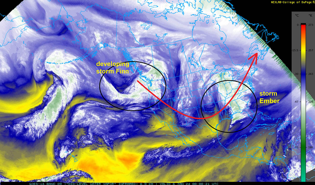
This weekend, the satellite across North America reveals an impressive atmospheric train of waves crossing from west to east, entering the United States and Canada from the Pacific Ocean.
This weekend’s storm Ember is underway across the East, while the new developing storm Finn is already organizing across the Pacific Northwest, moving southeast into western CONUS.
The attached video represents a quick overview of the rapidly deteriorating winter storm conditions across the Great Plains and Midwest next week. At the same time, the surface low continues deepening, and major snow and blizzard impact spreads towards the Great Lakes.
As Finn tracks towards the Northeast, the cold front brings significant weather and severe thunderstorms for the Southeast U.S. and East Coast.
But, before we head into deeper details regarding the potential evolution of the winter storm Finn next week, let’s have a quick overview of the Polar Vortex responsible for significant winter weather events in the northern hemisphere. And why it is essential to know when we track our daily weather.
WHAT IS THE POLAR VORTEX
The Earth’s atmosphere is built of six layers rounding our planet. The majority of the dynamics for our daily weather occur in the lowest two layers. Those two are known as the troposphere and the stratosphere layers.
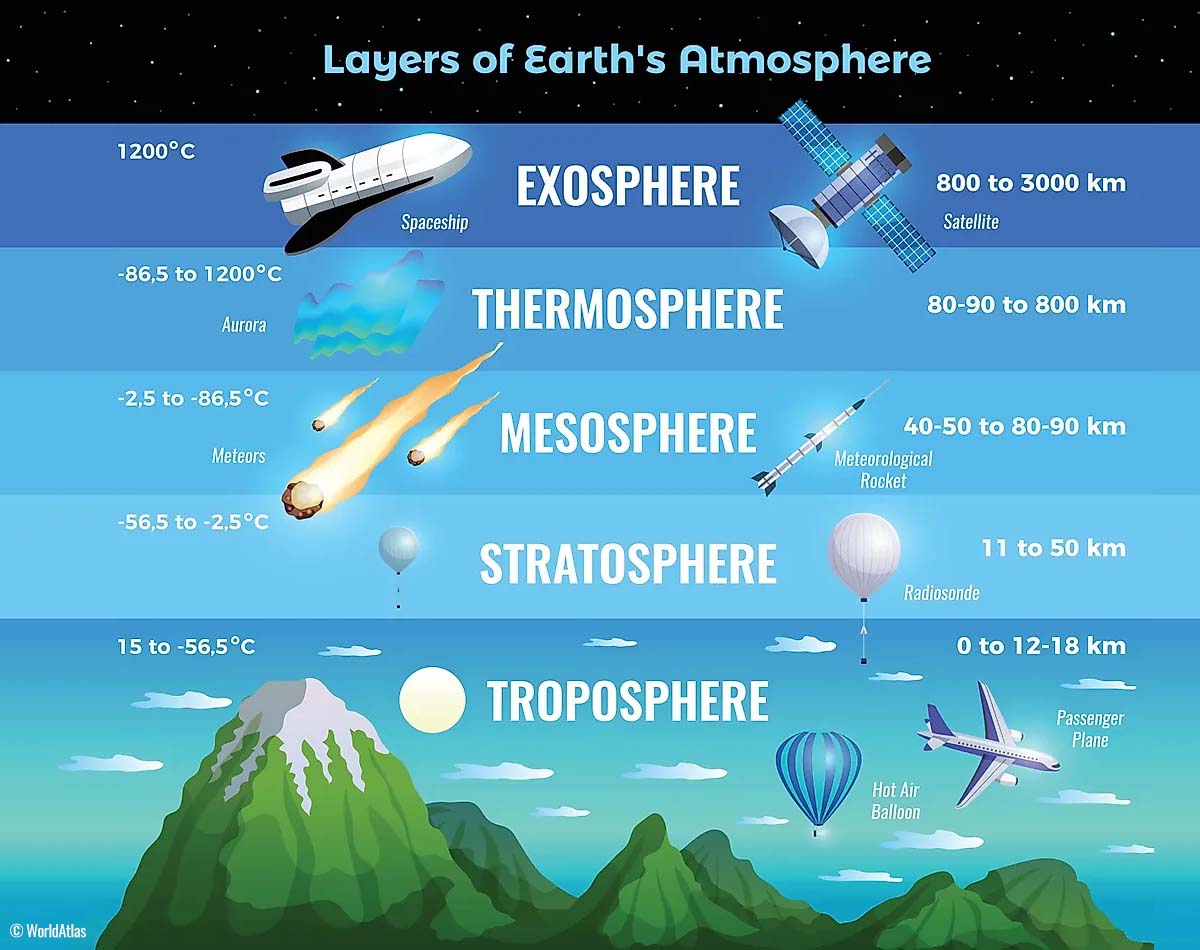
The layer that is the closest to the Earth’s surface is the troposphere. It is about 12 km deep layer, extending from the ground up high into the sky. The depth of it varies from around 8 km to almost 20 km, depending on where you live. The troposphere is the deepest above the equatorial region but gets much thinner above the North and South poles.
Above this layer is a much deeper one known as the Stratosphere. It is an 11-50 km thick layer with very dry air. The stratosphere also has the Ozone layer, vital in protecting our planet’s life against the potential solar storm impacts from the Sun or outer space.
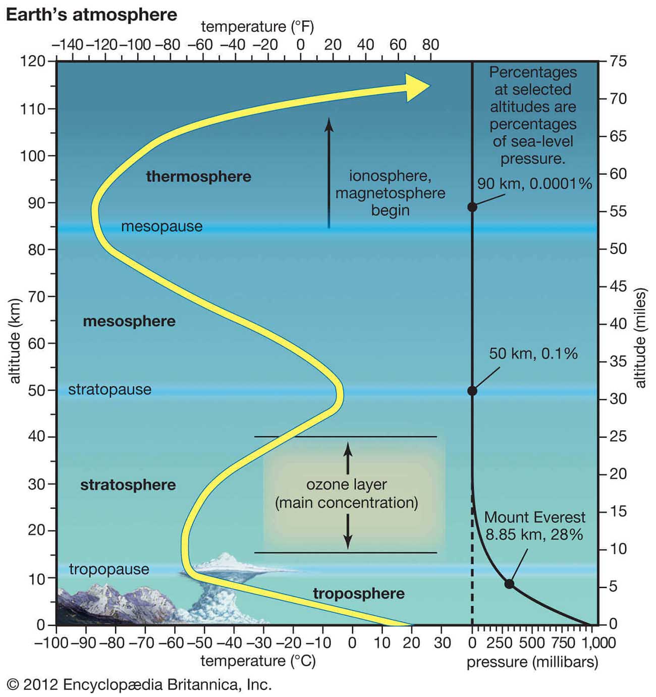
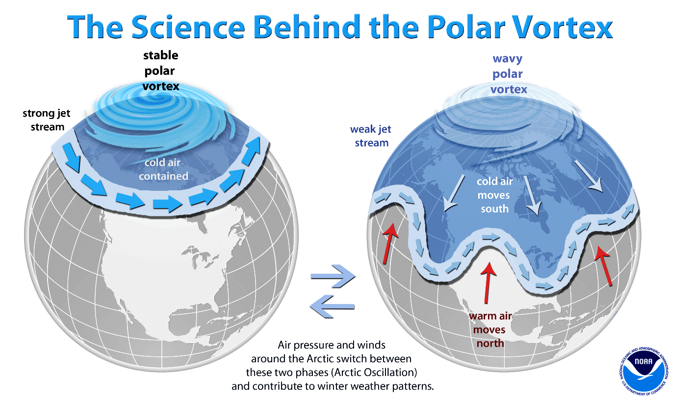
Another essential feature in the stratosphere, which makes our weather even more variable, often triggers significant large-scale weather events. This is the Polar Vortex, an enormous, tri-dimensional ring of powerful winds moving through the sky above us. The Polar Vortex is spinning around the North Pole, grazing through the air at about 20-50 km above the Earth’s surface with violent wind speed.
The troposphere and the stratosphere are crucial for our climate, as the Polar Vortex covers most of the bottom half of the atmosphere. Since the vortex extends from the middle of Earth’s troposphere up into the stratosphere layer, it has the main major effect on the winter weather across the high and mid-latitudes yearly.
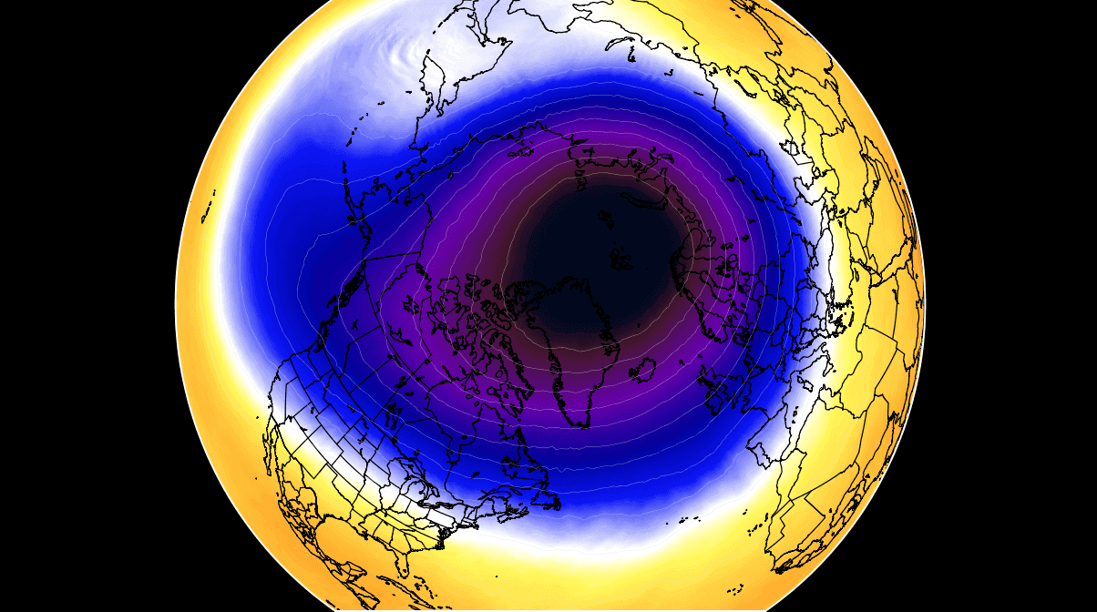
We could experience this in Canada, the U.S., and recently in northern Europe and Asia as the vortex has been disrupted and shifted on the other side of the northern hemisphere.
The Polar Vortex is the strongest during winter in both the Northern and Southern hemispheres. Although it spins well above our heads, it remains closely connected with the lowest parts of our atmosphere. Thus, it leads to our daily weather shape in many different ways, as it generally works as one sizeable hemispheric circulation.
Mainly, the Polar Vortex above us has triggered all the dynamic weather systems, from the frigid cold outbreaks and winter storms in Canada and the United States to the lack of winter weather and snow in other parts of the northern hemisphere.
How and when the Polar Vortex forms?
During the fall months, the polar regions receive much less energy from the Sun. This way, the cooling over the northern regions becomes more robust, and as a result, polar nights also occur for several consecutive months, with days without any sunlight following.
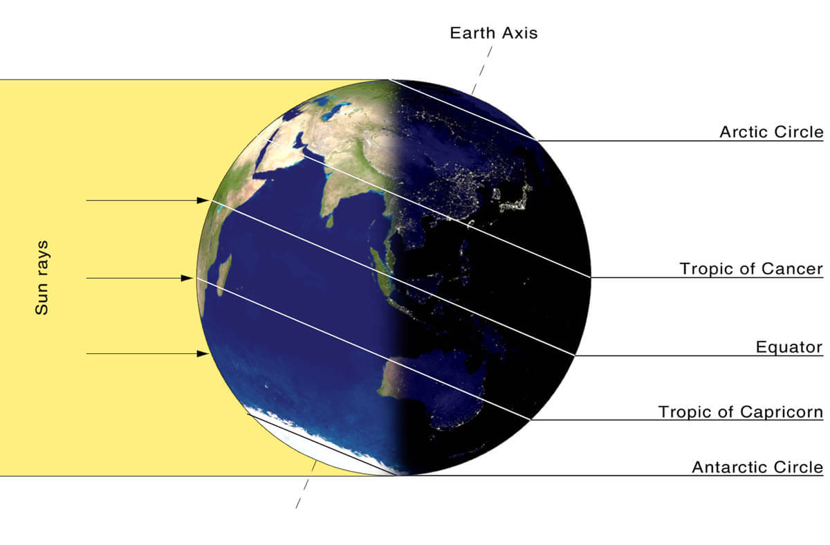
While the temperatures in the polar region are dropping into deep freeze, the atmosphere layers farther to the south are still relatively warm as they receive more of the sun’s energy simultaneously. Therefore, the south’s equatorial layers remain much warmer than the areas farther north. So this leads to a high-temperature contrast between them.
Cooling the polar regions also lowers the ambient surface pressure, with a similar weather process also happening in the stratosphere layer. Therefore, the temperature difference between the North Pole and the equatorial areas increases across both layers. This creates a large low-pressure cyclonic circulation across the polar stratosphere, where this feature became famous – the Polar Vortex.
Putting all these puzzle pieces together, the Polar Vortex is an enormous cyclone in our atmosphere. It expands across the North Pole during winter and sometimes becomes very intense, extending south to the mid-latitude regions. The same is also happening in the southern hemisphere during their winter period as the Polar Vortex intensifies around the South Pole.
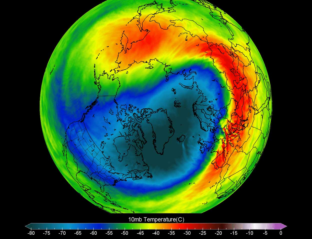
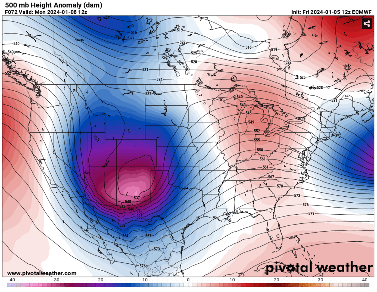
The weather model chart above hints at a very typical situation of the Polar Vortex fully established above us, representing the pressure at around 30 km (18 miles) altitude. This area is near the top of the stratosphere layer during winter.
The active and strong Polar Vortex during the Winter season 2023/24 has been the main trigger behind the frigid cold outbreaks over Siberia and recently across Lapland in northern Europe. Meanwhile, the most intense part of the vortex, its southern lobe, is gradually shifting towards the North American side of the northern hemisphere.
Deep Wave Emerges Across the United States Next Week
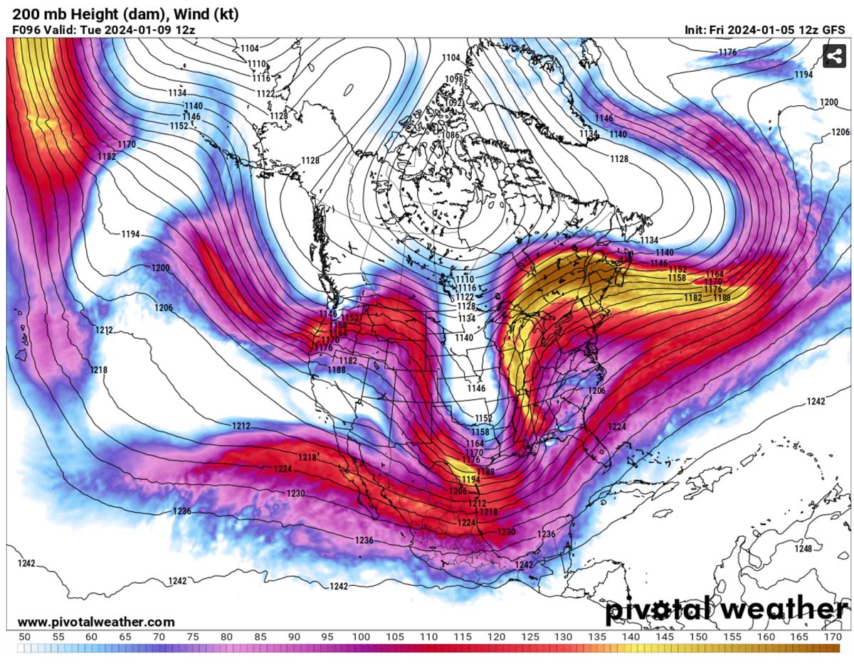
The general weather picture shaping up across North America in the coming days indicates a major and deep upper-level wave digging far south from Canada into the U.S.
By early next week, the wave gradually transforms into an upper low and reaches deep South.

This is a significant disturbance in the upper levels, leading to a major winter storm across the Contiguous U.S. It drags colder air mass in its wake, clashing with moist and warm air from the Gulf region.
Thus resulting in significant winter weather on the side of the storm and dangerous storms on the front side. The following chart represents the upper-level winds where a deep wave disturbance leads to the wave cutting off into the southern CONUS.
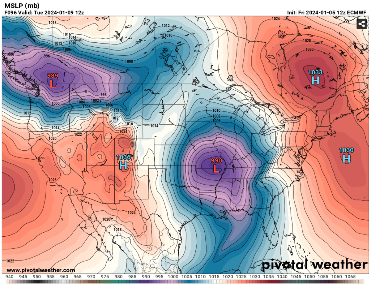
In response to significant high falls in the upper levels as the low digs this far south, the pressure falls will lead to surface cyclogenesis from the southern Rockies towards the Great Plains Monday, strengthening further east towards Mississippi Valley early Tuesday.
The low will be pumping vast amounts of moisture from the Gulf towards the surface frontal system and, simultaneously, a much colder air mass in its wake from the northern Plains and Rockies. Thus, the front will intensify with significant severe weather Monday night into Tuesday.
Heavy snow with developing blizzard conditions will follow across the central Plains in the wake of the storm across parts of Oklahoma, Kansas, Nebraska, Iowa, and Missouri.
Conditions will deteriorate with time as the system continues deepening its central pressure and intensifying further on Tuesday.
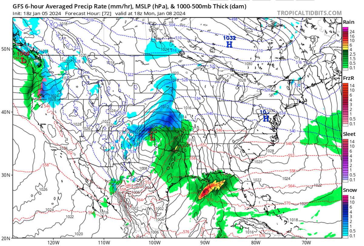
Ahead of the cold front, a large unstable warm sector will produce thunderstorms with potential tornadoes, damaging winds, and flooding for the South and Southeast U.S., quite rapidly moving east.
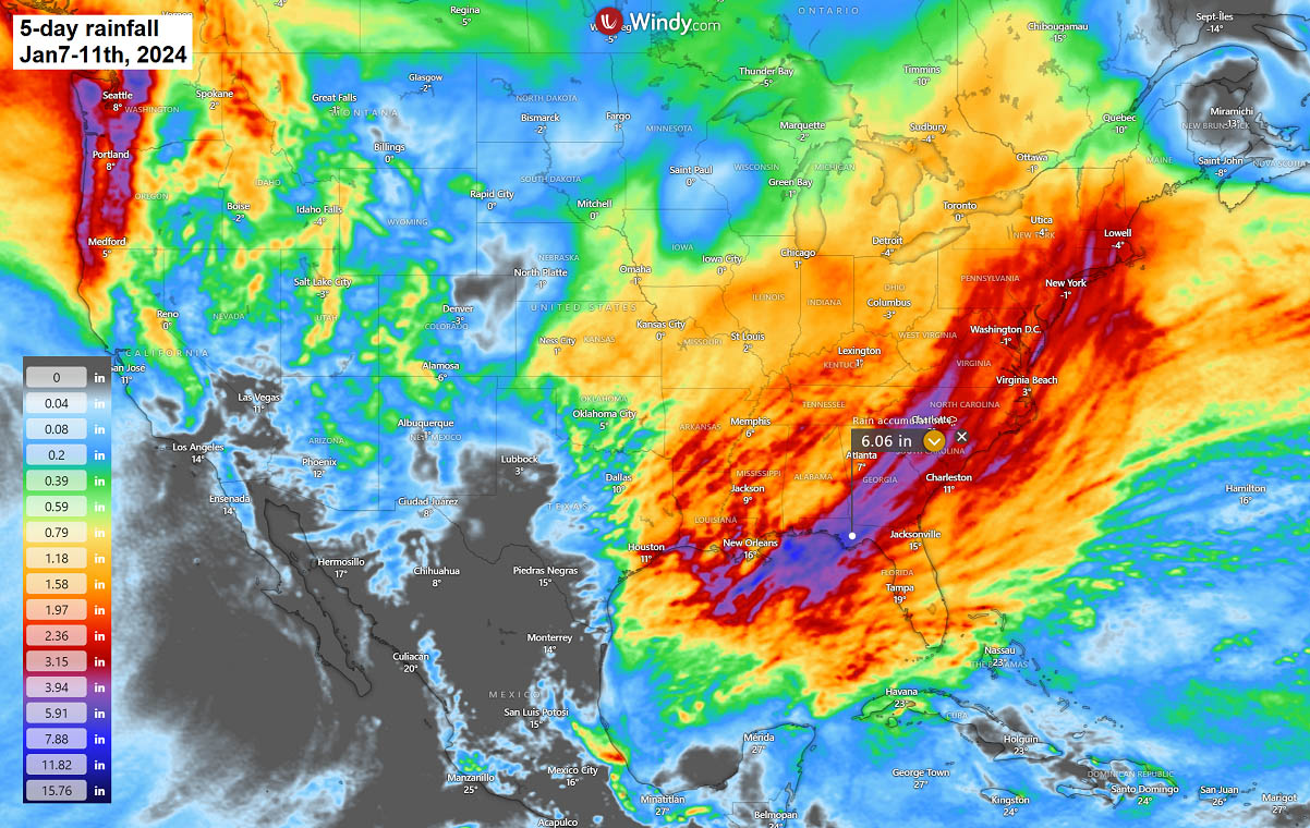
A swath of multiple rounds of storms will result in vast amounts of rainfall along the Gulf Coast and the Southeast U.S., with high amounts of rain likely to expand across the East Coast and Mid-Atlantic mid-week as storm Finn progresses further northeast.
Around 6-10 inches could accumulate in some areas, leading to flooding potential, precisely along the northeast Gulf Coast from the Florida Panhandle across southern Alabama and Georgia and further northeast towards Carolinas.
Heavy thunderstorms will also produce flash floods potential during the main cold front passage from Tuesday night into early Wednesday, besides the other potential threats, such as tornadoes and damaging winds.
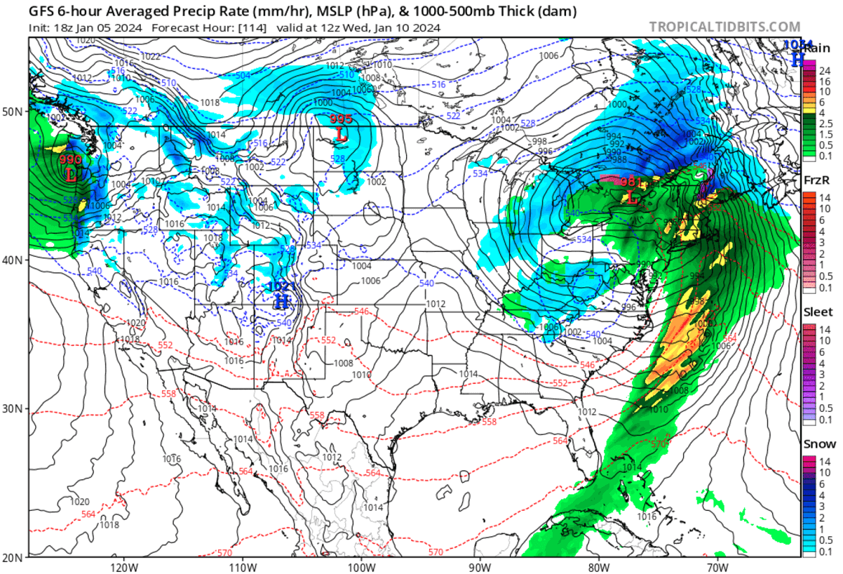
Major Winter Storm with Heavy Snow and Blizzard across the Midwest
Once the deep upper wave digs far south into the southwestern U.S. and the southern Rockies, it intensifies the surface low that ejects into the Great Plains. With a strong jet stream rounding the base of the upper core, the development of the surface disturbance will be pretty rapid.
The following charts indicate the position of the frontal system on Tuesday (left) and Wednesday (right). The swath of heavy snowfall and blizzard conditions is well seen across the Midwest on Tuesday, becoming more widespread and intense on Wednesday towards the Upper Midwest and the Great Lakes.
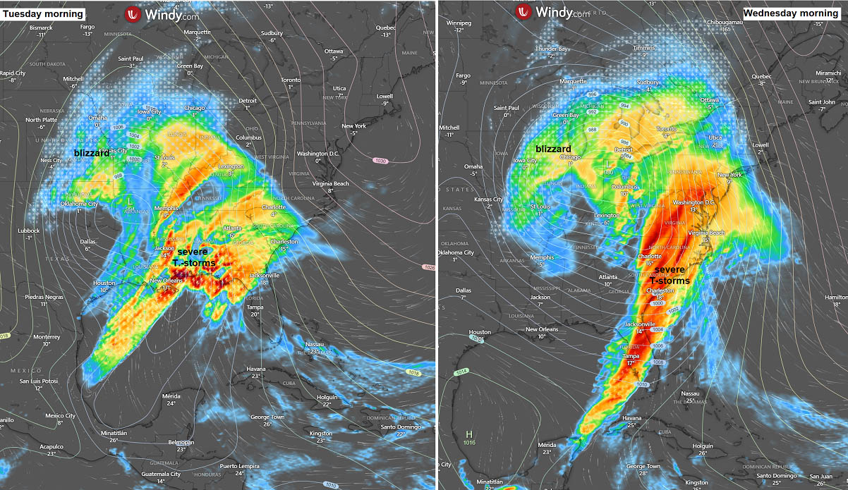
Also, there will be an intense swath of severe thunderstorms along the leading front across the Southeast and towards the East Coast Tuesday night into Wednesday morning.
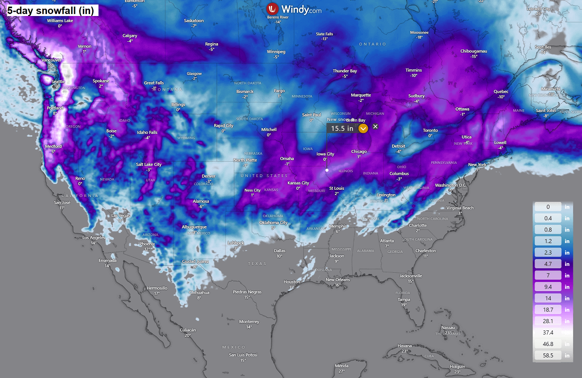
The amounts of snow will be significant, as the interaction of the moist southerly air mass and cold Arctic air mass from the north will be sharp. A swath of snow with 10 to 20 inches accumulated will be possible from Kansas and northern Oklahoma across Iowa and Missouri to Illinois and Michigan over around 36 hours.
The most significant snowfall will be along the northern edge of the strengthening surface low as it tracks northeast Tuesday into Wednesday. Blizzard conditions will develop with strong to severe winds in sharp pressure and temperature contrast. Significantly reducing visibility with whiteout conditions is likely to be expected.
Roads across the Midwest may become impassable with major travel disruptions on Tuesday into Tuesday night.
The following chart of peak winds from Monday through Tuesday indicates strong to severe winds will develop across the High Plains over Colorado, western Kansas, and Oklahoma/Texas Panhandle during the developing low and its cold air intrusion in the wake.
More significant, potentially severe damaging winds are forecasted across the Southeast U.S. and the East Coast, where thunderstorms will be ongoing. Peak gusts could reach 70-80 mph.
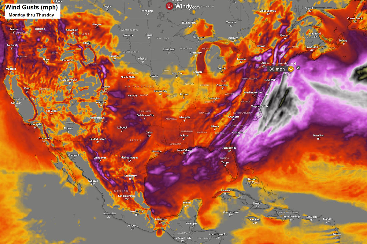
On Wednesday, the highest impact with the most severe winds will stay on the front end of the moving surface low, from the Gulf Coast to the Atlantic Coast and New England.
Explosive Development of the Surface Low and Winter Storm Towards the Northeast U.S. on Wednesday
With the progress of the upper-level wave through mid-week, the jet will become negatively tilted as it emerges into the Southeast U.S. on Tuesday night. This helps the surface pressure deepen further as the winter storm Finn tracks northeast significantly.
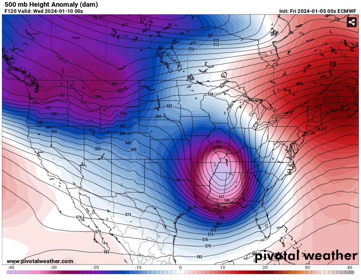
The surface low will become very large, dominating the eastern two-thirds of the country on Wednesday. The central pressure is forecast to deepen from around 995 mbar on Tuesday to around 972-973 mbar by midday on Wednesday, so more than 20 mbar within 24 hours.
The core of the low on Wednesday will be over the Great Lakes, moving northeast into eastern Canada Wednesday night. It will be a very windy day across the East Coast and Mid-Atlantic, as well as across New England, with significant waves into the coast. Combined with heavy rain.
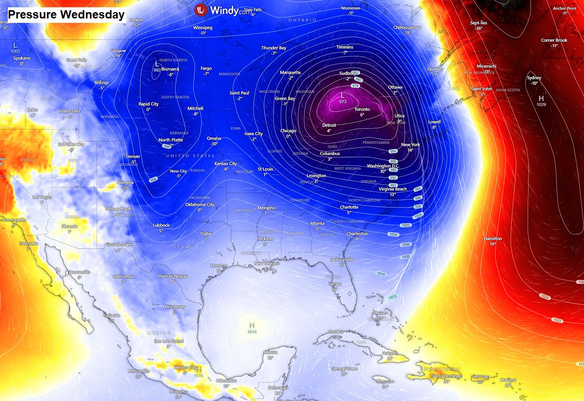
The attached chart indicates the frontal system position on Wednesday morning. We can see a solid and robust cold frontal boundary extending from New England towards the southwest off the Atlantic Coast.
Snowfall will be limited to the far western edge of the surface low, across Ohio Valley and central Great Lakes. But the amount of snow will only be moderate.
As we have seen on the snow forecast above, there is a 10-20″ snow forecast for the Appalachians and Northeast U.S. over the next 5 days. This snowfall will be dumped by the ongoing storm Ember this weekend.
Winter Storm Finn is not expected to deliver more snow into this region, as it will be placed under a much warmer air mass, with the cold air staying farther west until the following weekend.
This will also increase flooding potential as any fresh snow from storm Ember will melt fast once the much warmer air mass associated with Finn overspreads the East Coast.
Potential Increases for a Major Arctic Outbreak with Frigid Cold Air Mass Next Weekend
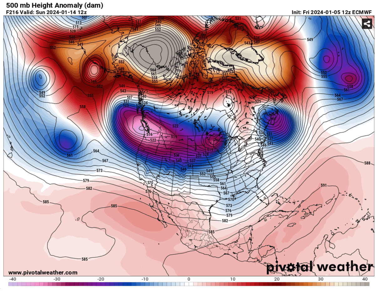
The Winter Storm Finn will be rapidly ejecting off the United States and Eastern Canada late next week when a new large wave is forecast to follow from Arctic Canada and the Pacific Northwest. The general weather model consensus is in good agreement for a major Arctic outbreak from the north next weekend.
The following chart for North America hints at this large upper wave/low developing on Saturday and Sunday, with a significantly deep low again. This is usually a sign that a mighty cold will likely be expected.
The cold outbreak is forecast to develop over the weekend, with a significantly colder Arctic air mass spreading into Western Canada first, then into North and Northwest United States from the weekend into mid-January.
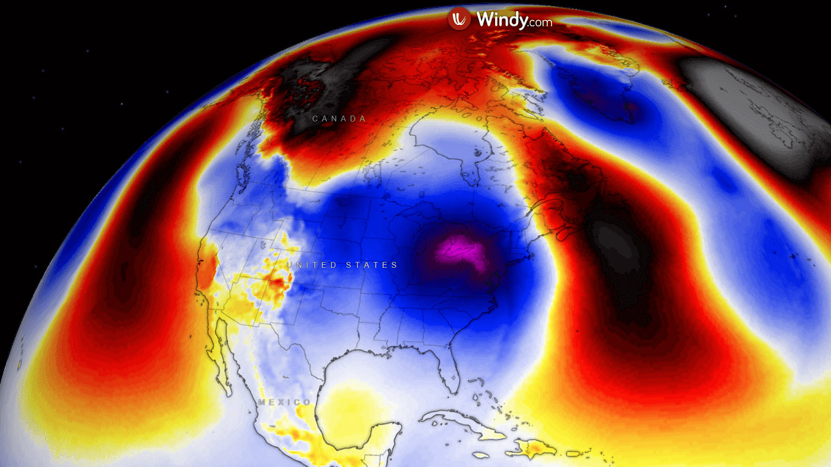
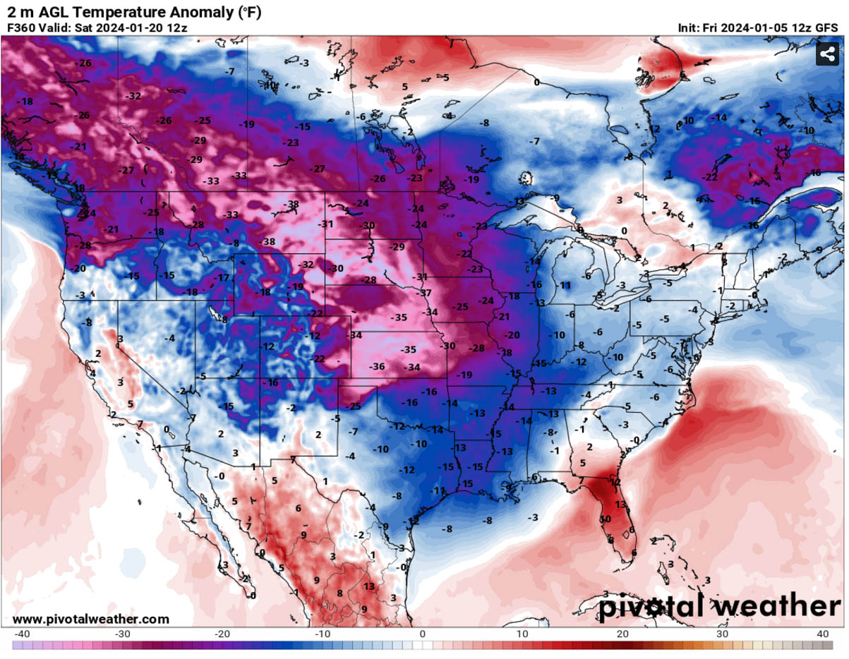
The mid-range weather charts indicate an impressive temperature anomaly across the Northern Rockies and Canadian Prairies on Saturday through Monday and Tuesday, with an ‘off the charts’ anomaly, spiking even more than 25 °C below average at the 850 mbar level.
The cold is also gradually spreading east and south into north-central U.S.

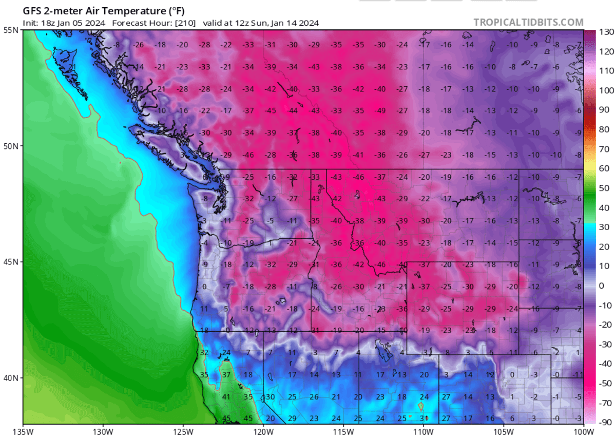
As we can see on the 2m temperature anomaly for Monday morning, Jan 15th, the temperatures are forecast to be extremely low. About 50 to 65 degrees F below normal.
This results in dangerous, frigid cold conditions for southern Canada and the northwestern U.S. states.

Temperatures on Saturday and Sunday through Tuesday will be extreme. Some areas have daily low temperatures into mid-40s to nearly -50 °F (-45 °C).
Temperatures will remain far below freezing, into 20-30 °F below during the daytime hours.
While the south and central U.S. might initially stay in relatively mild conditions, the Arctic cold pool will likely spread east and south through mid-January days, as the weather model forecasts suggested.
The long-term projections hint that the Arctic cold could persist well into the week after, through mid-January, and gradually expand across large parts of Canada and the United States.
How far south and intense the cold would be is yet to be determined as these charts show more than 10 days ahead of now. But the consensus is entirely aligned that a major cold is shaping up.
There are also hints that more winter storms could follow ahead of this large Arctic cold pool so that conditions will be monitored for potential impacts. Stay tuned.
Wxcharts, Windy, and Pivotalweather provided images used in this article.
See also: