A Stratospheric Warming event has now begun, and is expected to play its role in the large-scale weather pattern change in the first half of January. With snow events over the United States and cold air periods over Europe, the second winter month finally delivers proper weather.
We first discussed a major January weather pattern exactly a month ago. Then, the new long-range indicators showed a shift in the pressure anomalies for January. The main culprit at that time was El Niño, as the stratospheric warming was not yet properly resolved.
But, as you will see, both the El Niño and the stratospheric warming event will join forces, helping to create very dynamic weather patterns over the entire month of January, with indications of winter weather extending into February with a small break in between months.
AS WEATHER PATTERNS CHANGE
The first month of the meteorological winter is now behind us. It did not bring much winter weather across the mid-latitudes of the Northern Hemisphere. The case was especially unusual across the United States and Canada.
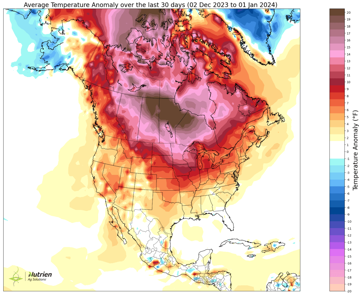
Below, you can see the temperature analysis for the past 30 days, covering the month of December. It shows unusual high-temperature anomalies across Canada and the United States. This was the result of a strong jet stream pattern from the Pacific.
As the peak of this warm weather pattern was just starting in mid-month, we were already looking ahead into January, as a significant pattern change was looming.
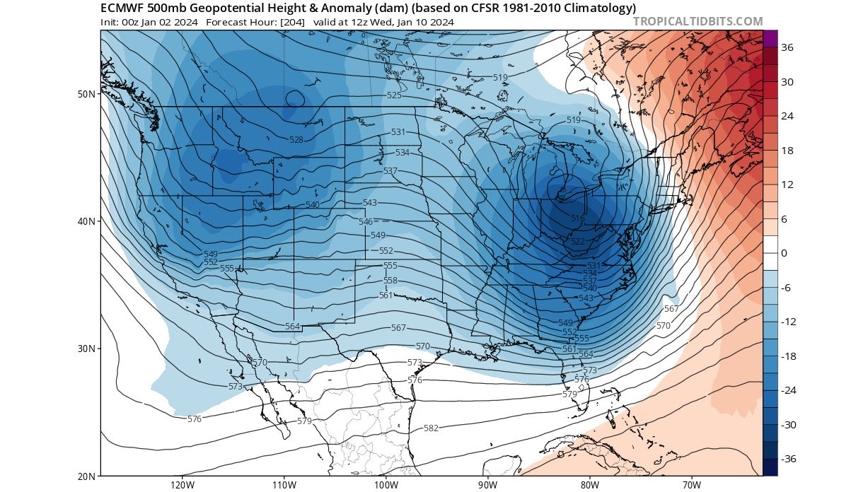
Below is an old forecast by ECMWF, issued in mid-December. It shows the pressure anomaly for the second week of January 2024, almost a month ahead. At that time, when warm anomalies were spreading across the United States, it seemed more like fiction than reality.
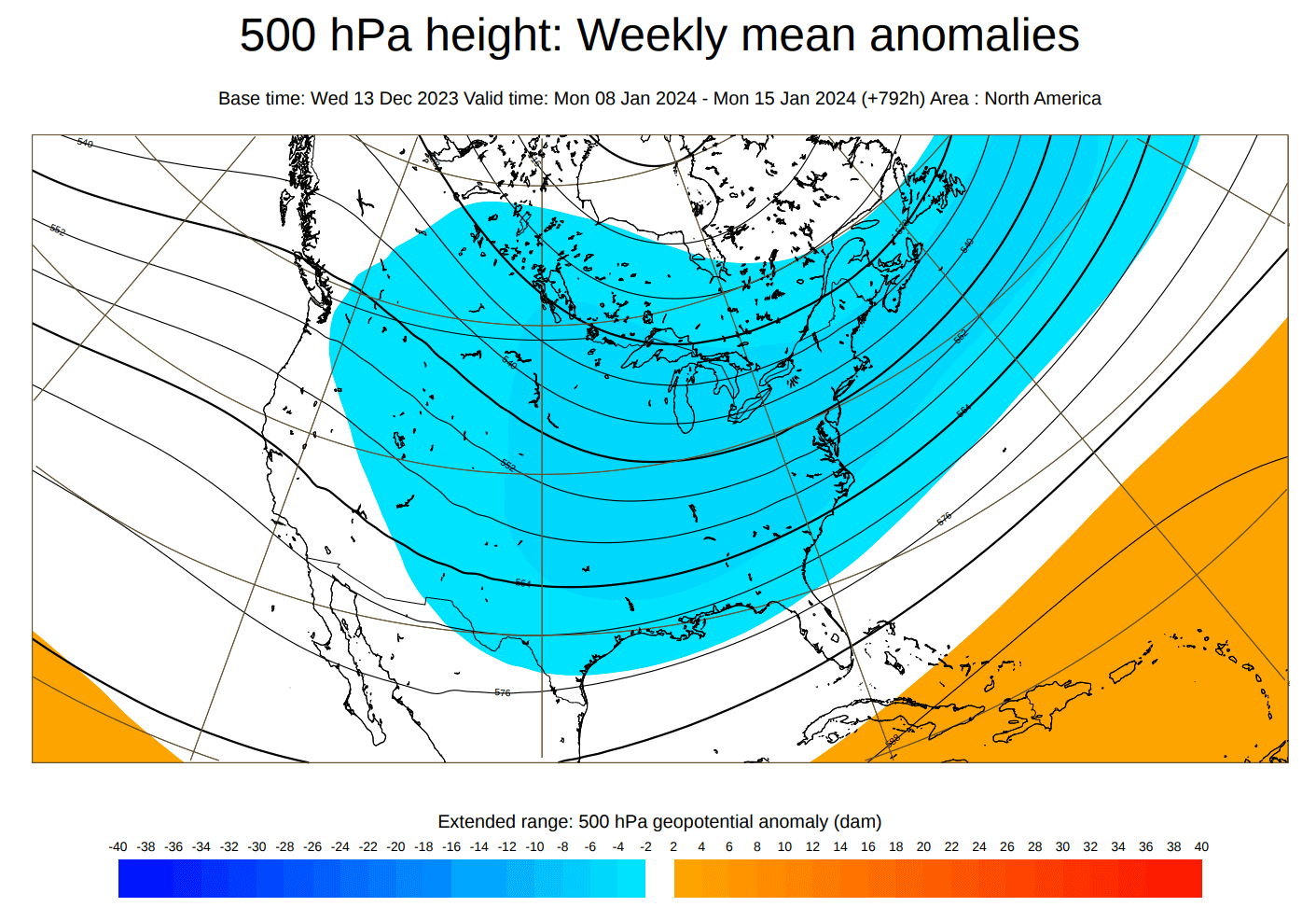
But in most cases, looking this far ahead, even if only at trends, is really more fictional than real. But this case was different. It had support from different weather models and support from the large-scale weather drivers.
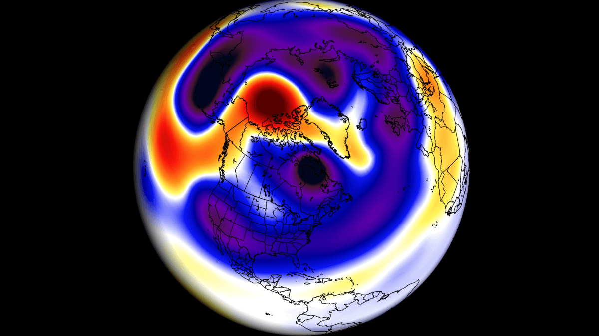
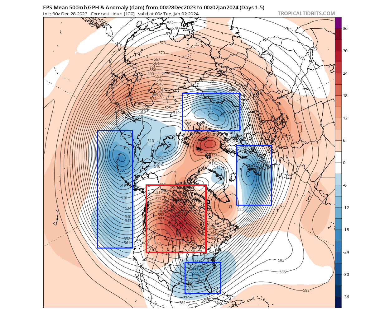
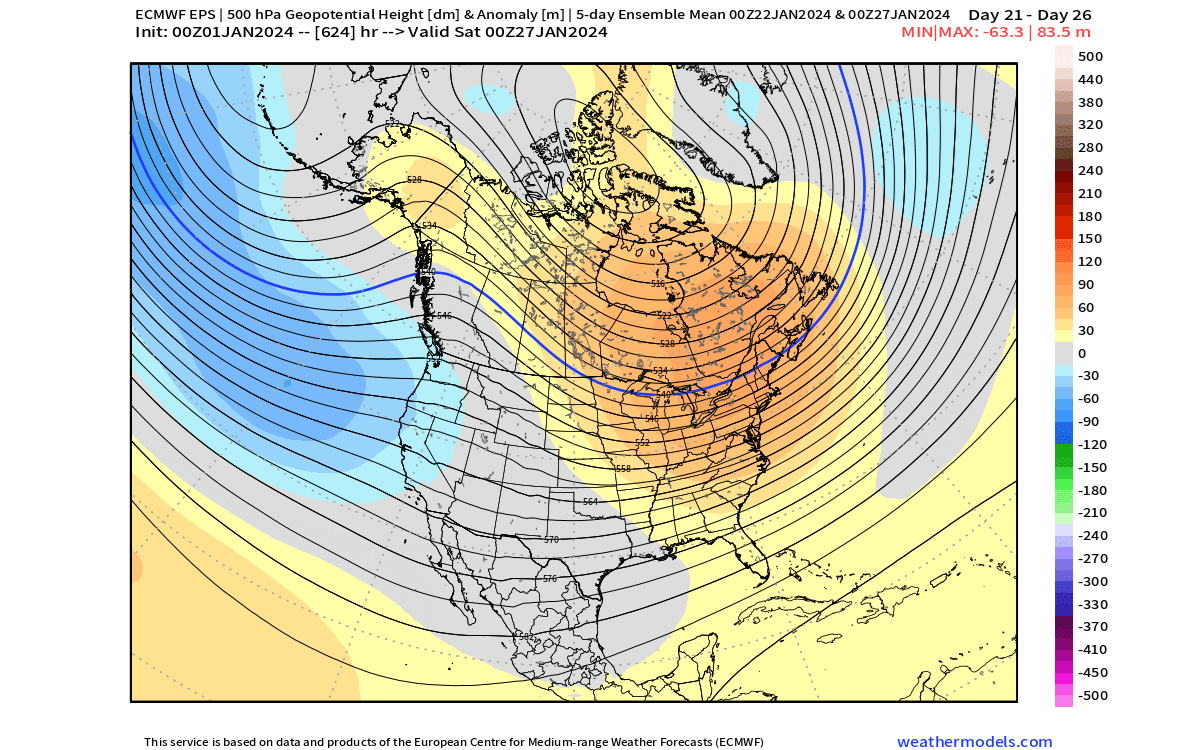
So now we can look at the latest forecast for the same period. You can see the pressure pattern forecast below for the second week of January. Notice the remarkable high-pressure system rising over Greenland, displacing the low-pressure systems and cold air along with it.
This low-pressure anomaly over the United States looks pretty much the same as in the old forecast, looking a month in advance.
The reason we decided to show you this is because it is a great example of how looking weeks in advance can be helpful if it is done with the right approach. It also serves as a reminder of how no weather pattern lasts forever.
But where did this pattern change come from, and how long might it last?
WINTER WEATHER STARTS TO RETURN
Looking at the latest pressure anomalies, we can see a very disrupted weather pattern. A high-pressure anomaly still persists over Canada and the northern United States. Low-pressure systems are displaced a bit more to the south than usual.
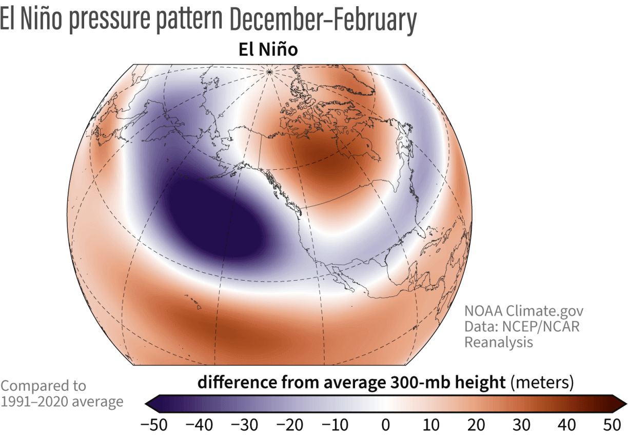
The main driver behind the weather patterns so far this winter is the El Niño in the Pacific Ocean. It began developing during summer. You can see its onset in the video below, showing a quite rapid ocean temperature change in a short period of time.
Below, you can see the average El Niño winter pressure anomalies. Notice the strong low-pressure anomaly in the North Pacific, exactly like we have seen in the past weeks. Also, you can see the high-pressure area over Canada and the polar regions, a constant feature in the future forecasts.
What we currently see is the expected progression of the El Niño pattern, which usually turns colder in January. Below, you can see the pressure anomaly across the United States and southern Canada for early next week.
Compared to December, we now see a very different picture, with low-pressure anomalies spreading across the United States, bringing cooler weather and slowly increasing the snowfall potential.
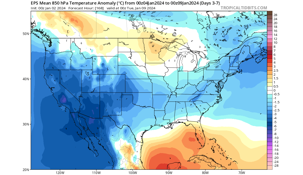
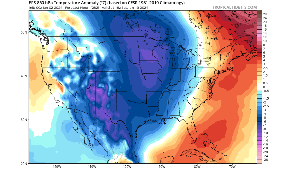
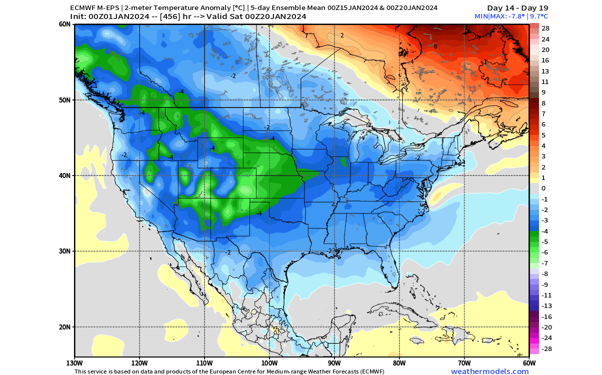
In the next image below, you can see the temperature anomalies for later this week and early next week. While we don’t see strong cold areas, we do see a temperature drop across much of the United States compared to late December.
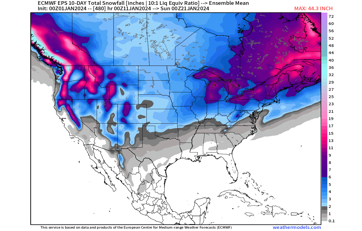
As we have mentioned snowfall, you can see the snow forecast below, which shows total snowfall by early next week. You can see snowfall across the western United States, but also a snow swath across the Plains, reaching across the Midwest up into southeastern Canada.
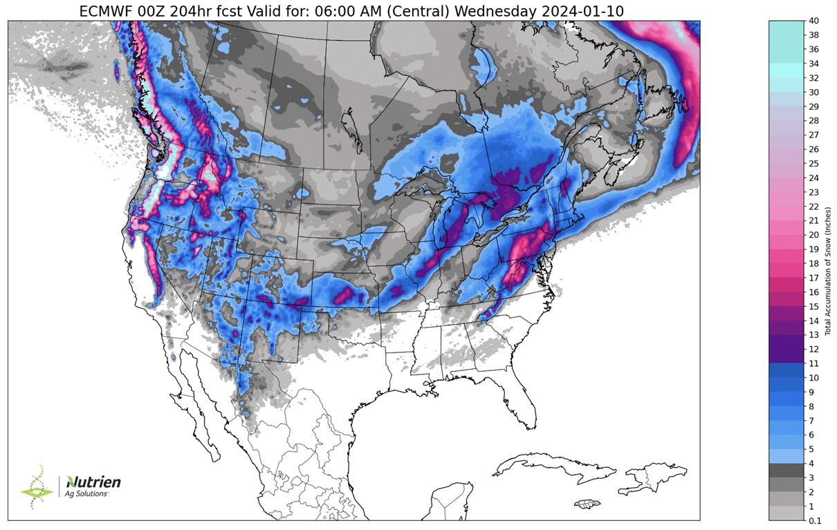
Also, notice the increased snowfall area over the northeastern United States, which is expected to get hit by a snow event early next week. This is a significant improvement over December, which saw record-low snowfall across the central and eastern United States.
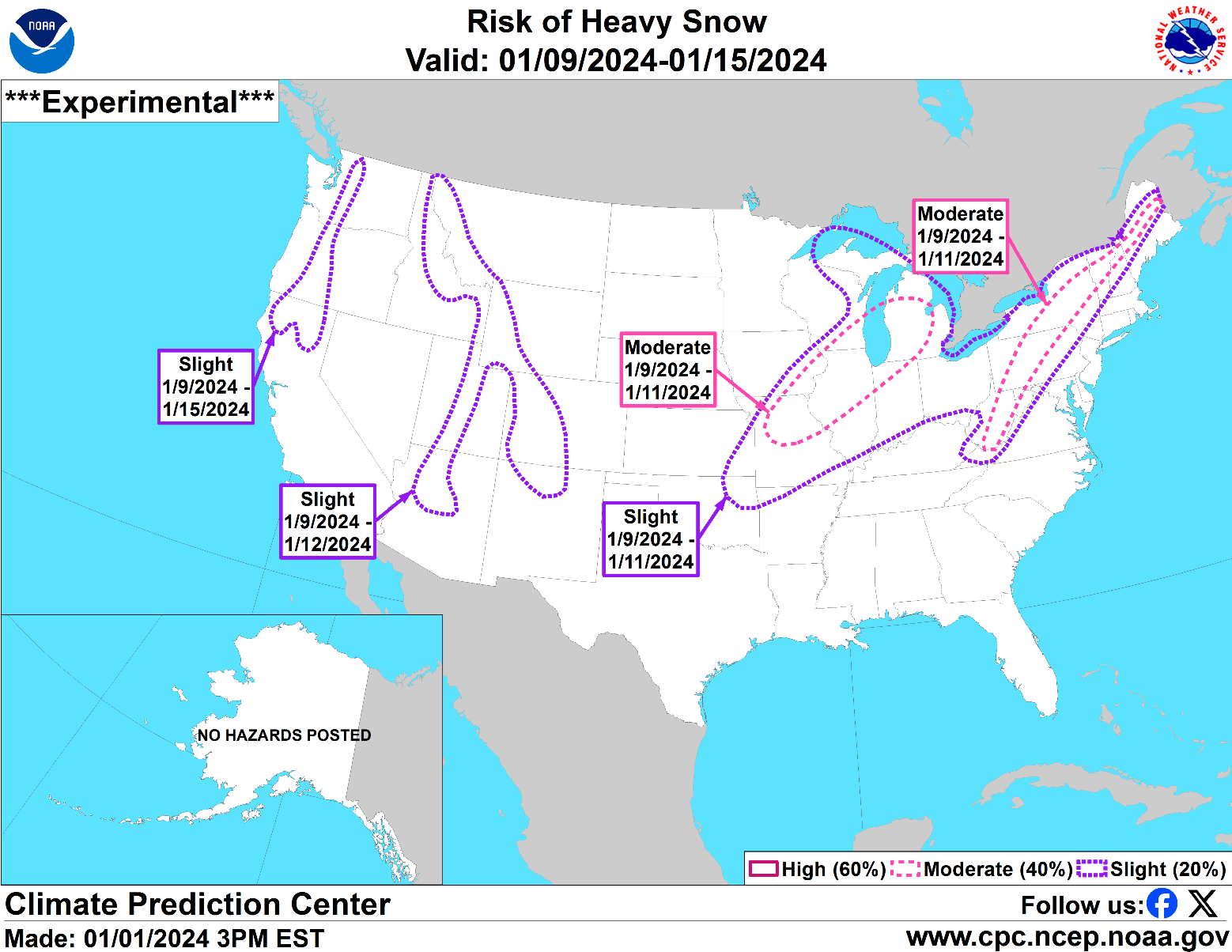
Below is the official NOAA heavy snow outlook for this period. Notice the best snowfall potential over the Midwest and over the northeastern United States. This is the best indication of a significant pattern change, as there was no heavy snow area over the east for quite a while.
Snow cover is also important for future cold air outbreaks over the United States. Snow on the ground over Canada tends to improve the quality of the cold air, as it is more resistant to warm up once it heads south, as snow cover generally lowers the ambient temperatures and reflects more solar radiation.
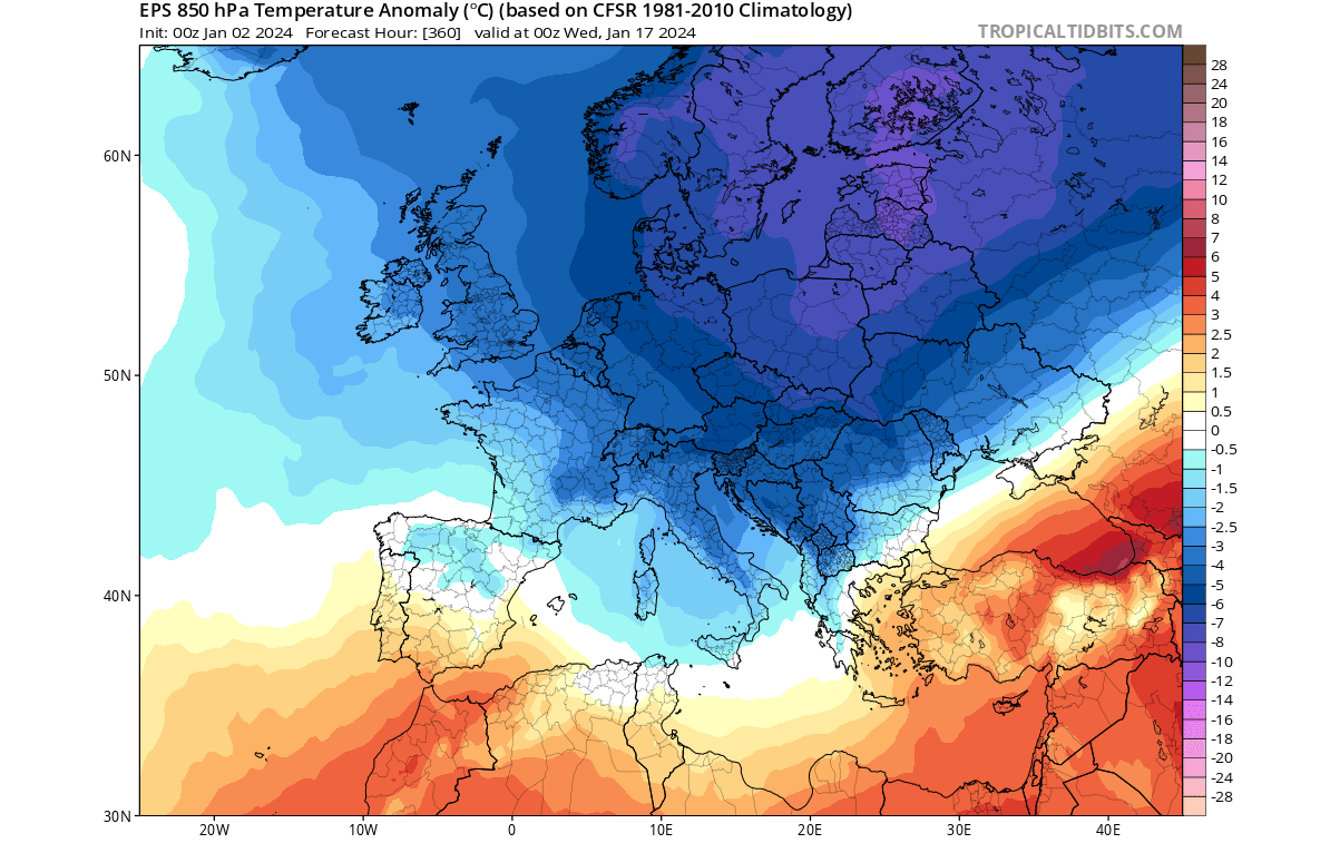
Looking at Europe for the next few days, we generally see warmer anomalies over the central and southern regions. Cooler conditions will prevail over the western parts, while the main cold anomaly is over the north.
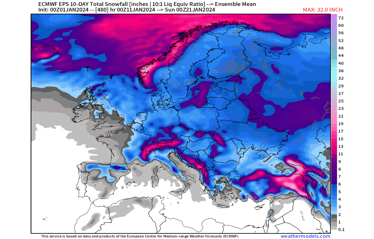
The snow forecast by early next week does show snowfall potential across Europe, as the colder airmass from the north is forecast to descend to the south by early next week.
But while winter is slowly returning to the United States and Europe, another event is ongoing high above in the stratosphere. A stratospheric warming event is starting and will play its role in keeping the winter weather patterns around for a little bit longer.
WINTER WEATHER FROM THE STRATOSPHERE
A stratospheric warming event basically means a strong temperature and pressure rise in the Stratosphere. That causes a major disturbance around the Polar Vortex and, as a result, creates a disruption that can link downwards, impacting the pressure pattern in the lower levels of the atmosphere.
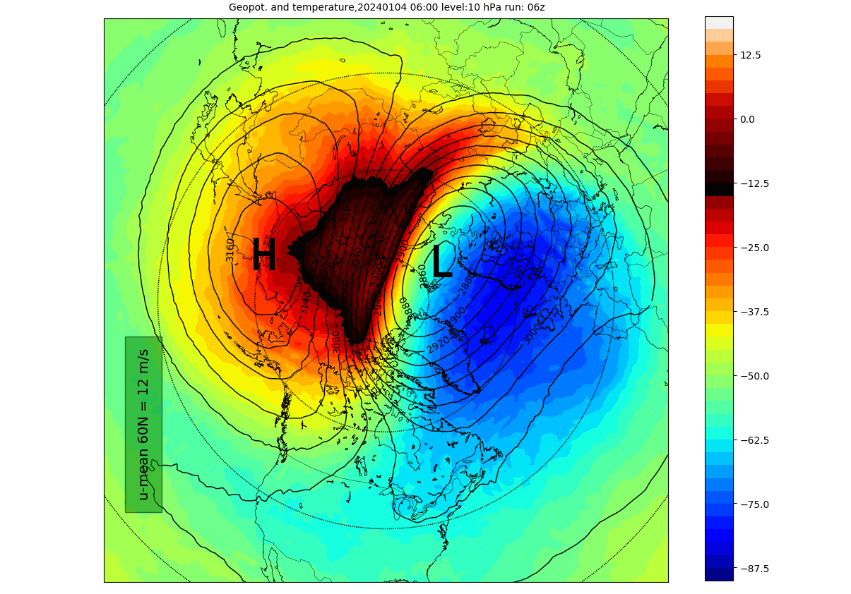
Below, you can see the latest state of the stratosphere at the 10mb level (30km/18.5miles altitude. The low-pressure system is the polar vortex. You can see a strong high-pressure system pushing it out of the pole, with a significant stratospheric warming anomaly helping to further weaken the polar vortex.
The two graphs below show wind speed and temperature at the same altitude in the stratosphere. You can see a rapid wind speed reduction of the polar vortex and, at the same time, a rapid rise in temperature. It reveals a strong ongoing disruption process.
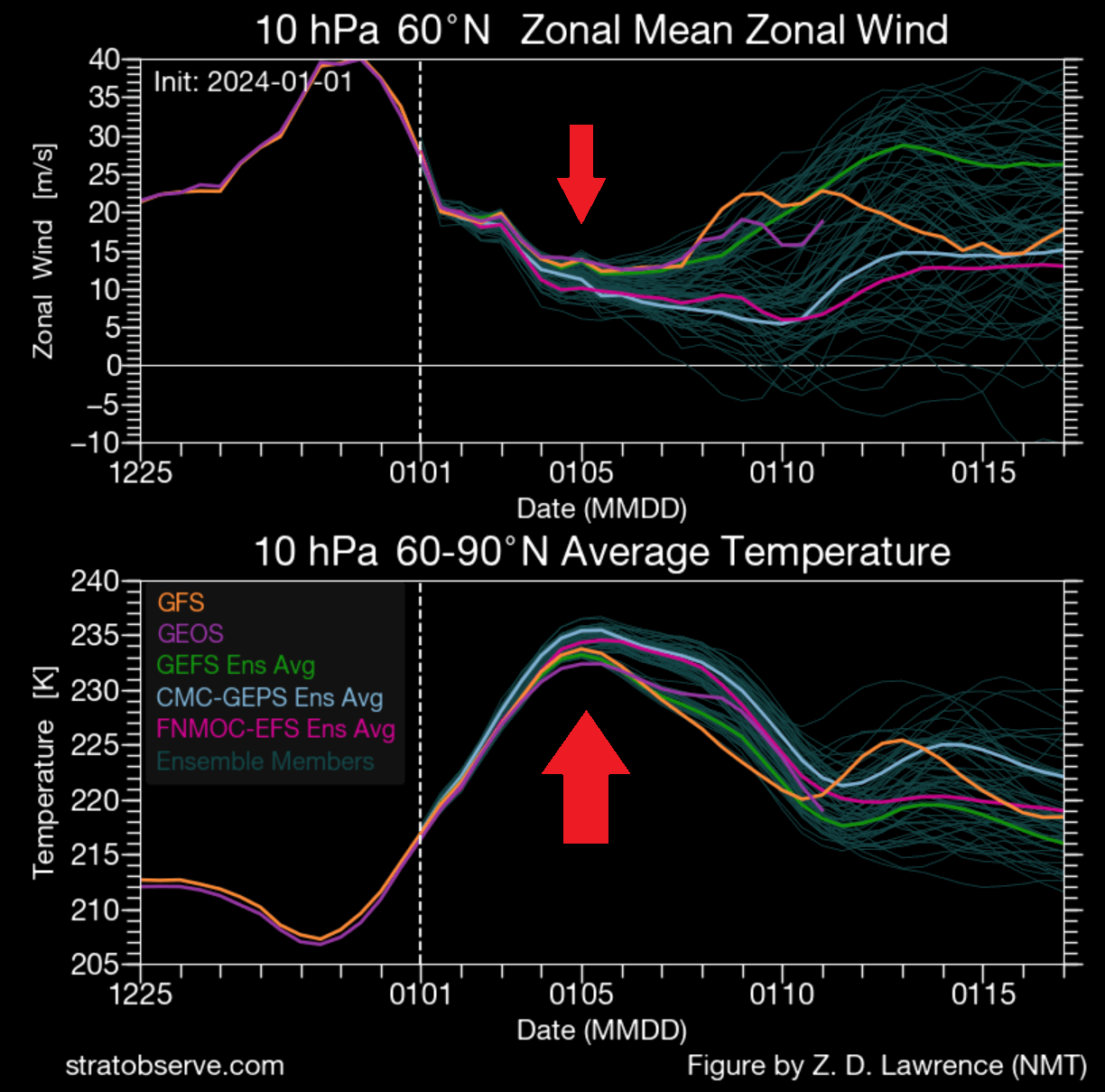
In early January, normal conditions are strong polar vortex winds and very low temperatures. By monitoring these two parameters, we can see a disturbance starting and what the forecast is. It helps us quickly indicate changes in the stratosphere and if there is any potential for surface impacts.
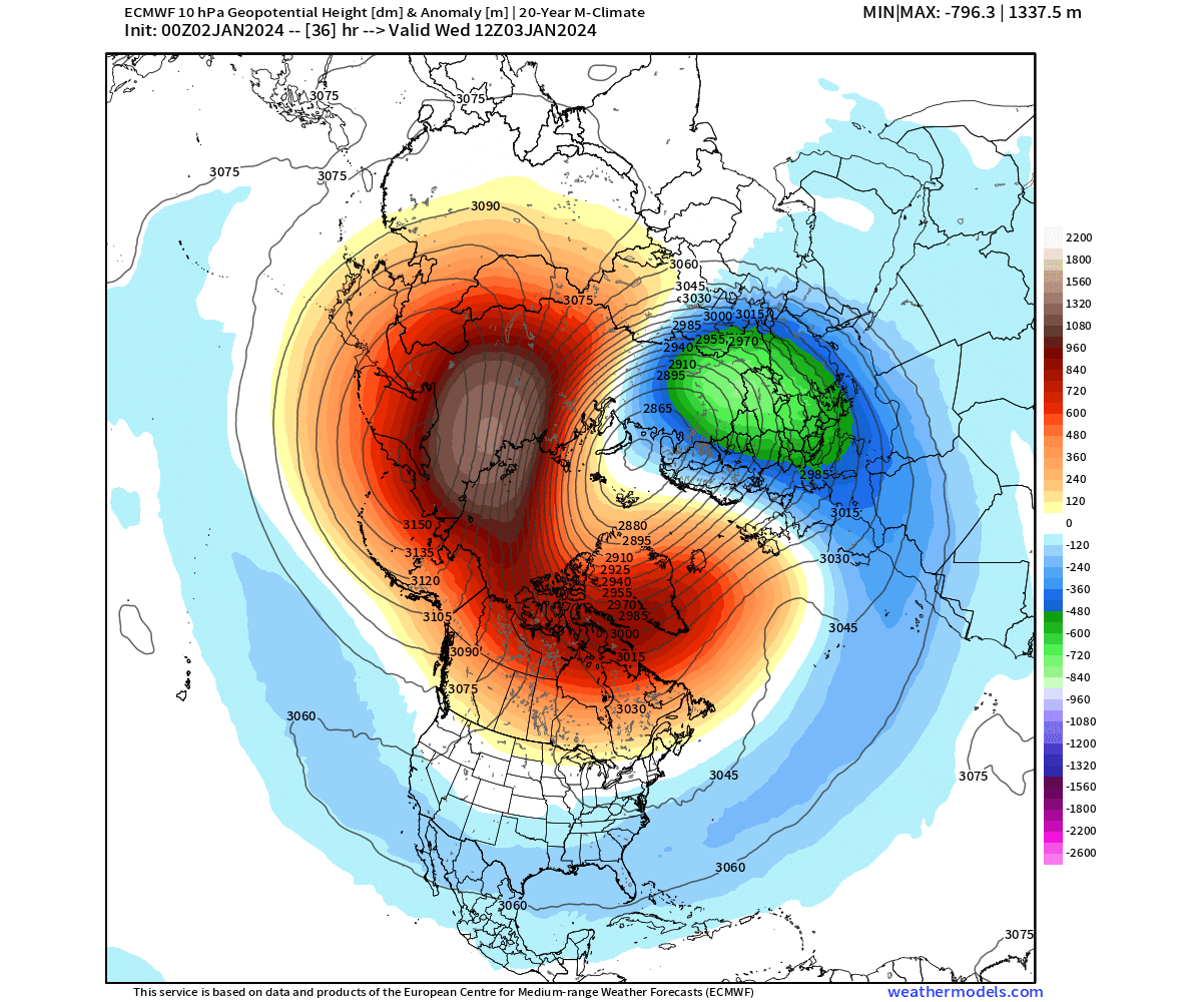
In the next image, from weathermodels, is the pressure anomaly at the same 10mb level. You can see most of the mid-stratosphere is under much higher pressure than normal. This is still at a higher altitude, but these anomalies can sometimes quickly link down to the lower levels and with the weather patterns.
The easiest way to track that is by simply looking at the vertical pressure anomalies. You can see that in the image below by stratobserve. In the lowest levels is the marked high-pressure anomaly at the surface. But you can see a strong high-pressure anomaly falling down from the top of the stratosphere in the forecast.
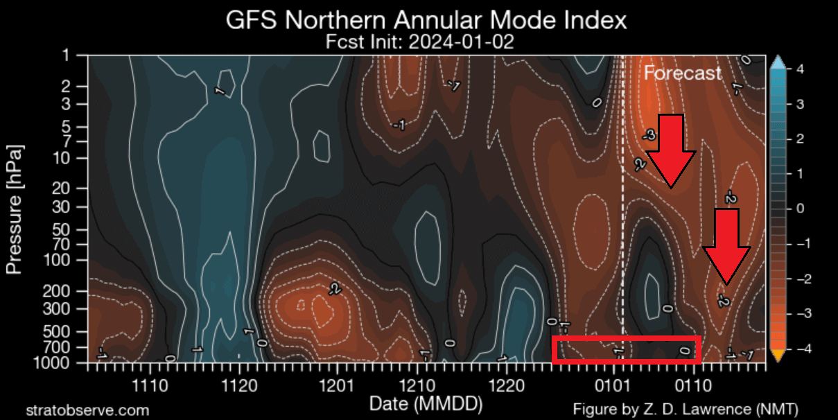
Based on this forecast, you can see the stratospheric high-pressure disturbance connecting down to the lower levels of the atmosphere, likely linking with the existing weather patterns. The first more obvious connection is around the 10th.
At this point, there is one important thing to know. The current weather pattern is already getting more disrupted thanks to the seasonal impact of the El Niño. At this time, we also have the stratospheric anomaly, which looks to connect down to the lower levels.
For this reason, there is a special image below, produced by meteorologist Eric Webb. It shows the usual percentage of major snow events across the northeastern United States in an El Niño winter, based on the past 150 years of data.
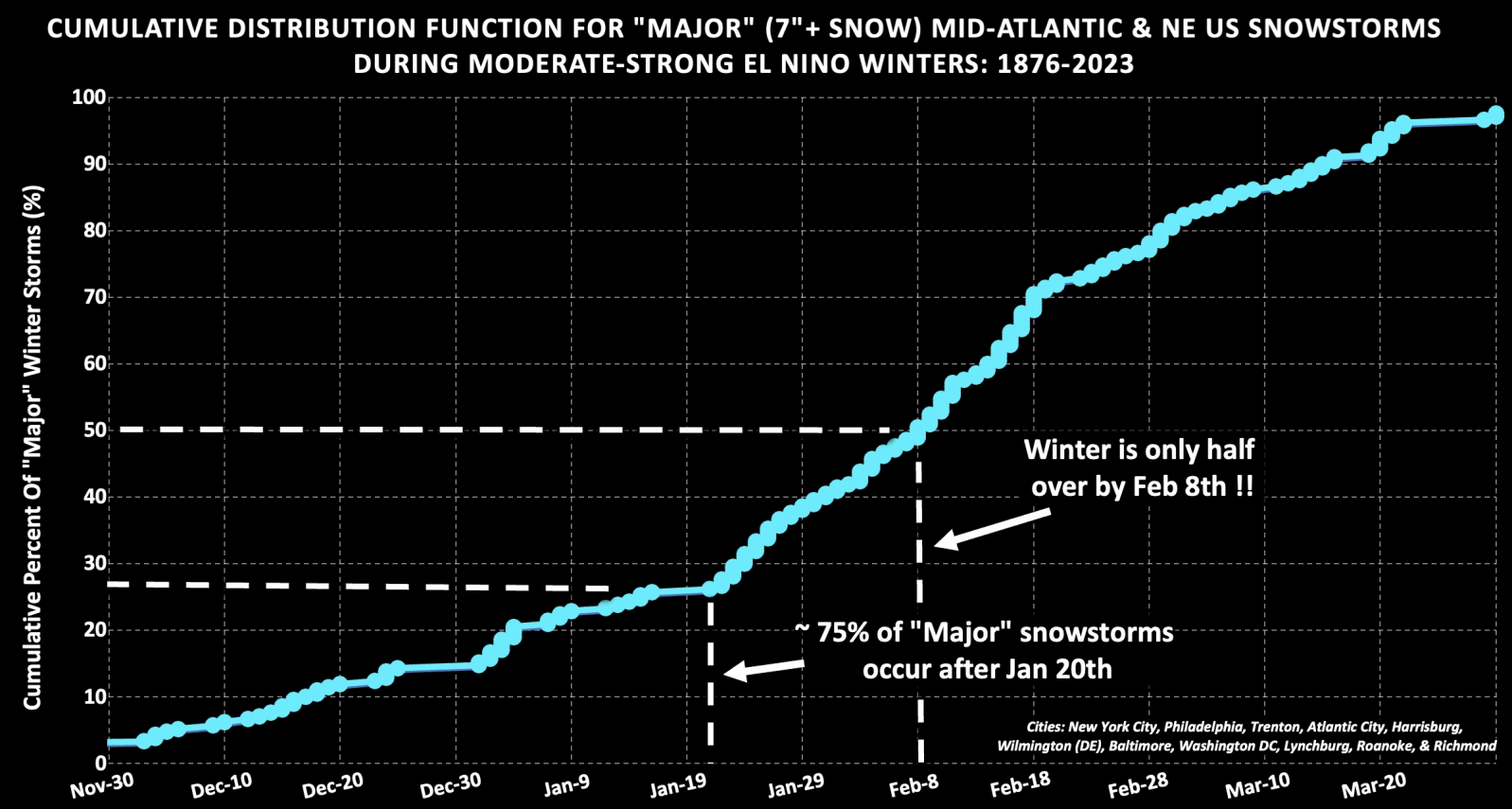
There are two main things to take away from this graph. First, 75% of major snow events over the northeastern United States occur after January 20th on average! Second, winter snow events are only half done by February 8th, with February usually being the busiest snowfall month.
So, winter is usually late to start across the northeastern United States during an El Niño. This has also been the case this winter, especially with the unusually warm December. But as things start to change, the seasonal impact from El Niño is starting to get evident.
And, in this case, it can very well happen that the anomaly from the stratosphere can actually help to strengthen and prolong the disrupted winter weather pattern that is already present in the lower levels.
LOW PRESSURE AND COLD WEATHER
As mentioned, the forecast indicates the stratospheric pressure anomaly connecting down to the lower levels of the atmosphere. Below is the pressure pattern forecast for mid-January, and it shows a very disrupted pattern with a strong high-pressure anomaly over Greenland.
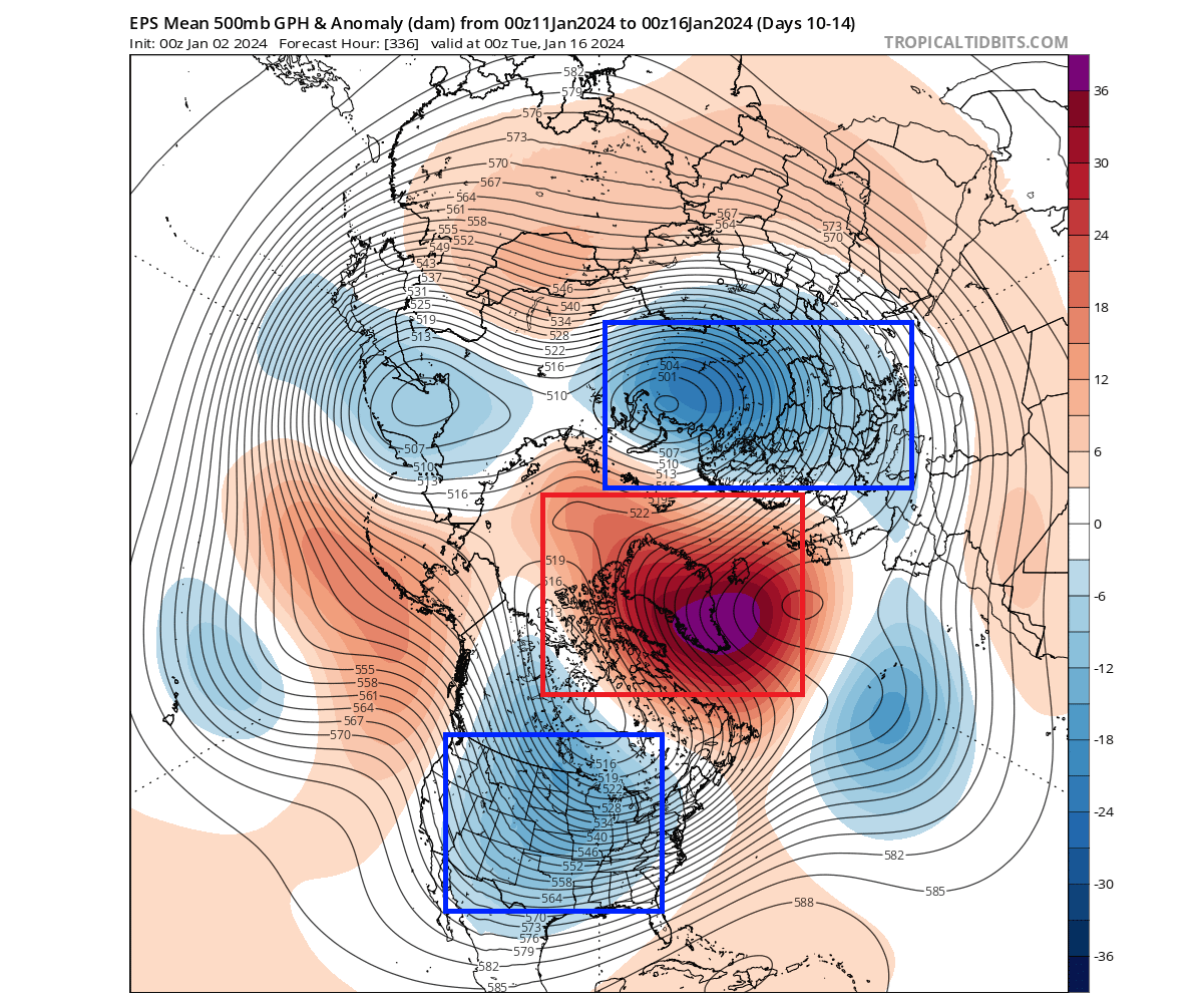
This pressure anomaly is exactly what we would expect to see after a stratospheric warming event. It is not created entirely by the stratospheric events, but it can get amplified thanks to the overall disturbance over the Northern Hemisphere.
Such a blocking anomaly is like a meteoroid hitting the ground, but in this case, it does not disperse soil but cold air. That usually follows around the low-pressure anomalies, like the large ones over the United States and Eurasia.
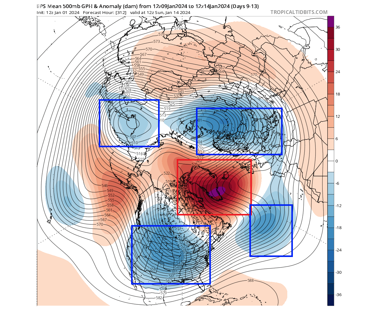
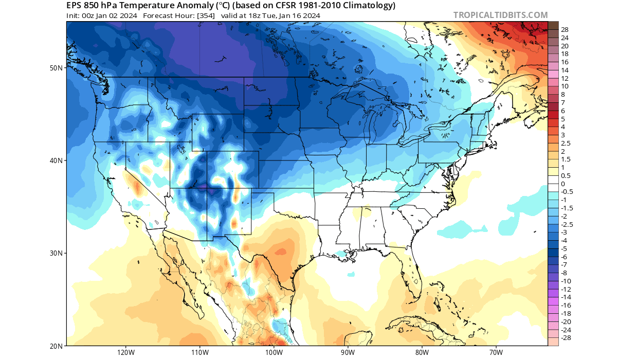
Speaking of cold air, we can see a strong cold wave in the forecast around mid-month, spreading from the northwestern United States towards the central states and to the east. This is the first major result of the overall shift and the re-alignment in the pressure patterns.
Looking further ahead into the start of the second half of January, the cold airmass is forecast to settle down over the northern United States and southern Canada. The cold anomaly also expands into the central and northeastern United States.
At this point, the biggest question mark is over the eastern United States, as the main axis of cold looks to be around the northern and central United States. But in reality, you do not need a strong cold anomaly to have snowfall potential over the northeast.
Below is the ECMWF ensemble snowfall forecast for January 11th to 16th. You can see an increased amount of snowfall over the western United States and the Pacific Northwest. And also, another area of increased snowfall is over the Midwest and the northeastern United States.
Overall, this is a much-improved snowfall outlook and a welcome one if you live in the northern and eastern United States and are a fan of winter weather.
Looking at Europe, you can also see the impact of the strong blocking high over Greenland, creating a colder air anomaly over much of the continent, thanks to a more northerly and easterly flow.
The snowfall forecast over Europe also shows a major improvement, with snow also over the lowlands and not just the higher elevations.
But as we have said before, no weather pattern lasts forever. As we finally get more proper winter weather to the mid-latitudes of the Northern Hemisphere, will it be over soon, or can it last?
SECOND HALF OF WINTER
As we go into the second half of January, we also enter the second half of the winter season. In this segment, we will look at the latest forecast trends for late January and early February. We will only look at North America, as the forecast skill here is higher due to the proximity to the El Niño event and its known effects.
At this point, we have to add that the following forecast maps are just the latest trends. Despite the success this forecast had in December in seeing the January cold pattern, these are not fixed weather scenarios.
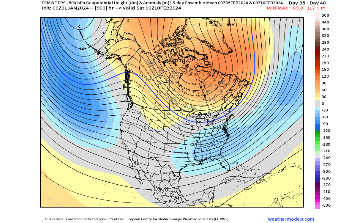
Looking at the pressure pattern in the second half of January, you can see the low-pressure anomaly continuing across the United States. The blocking high remains over Greenland, joining with the Canadian high-pressure area. Low-pressure area persists across the United States.
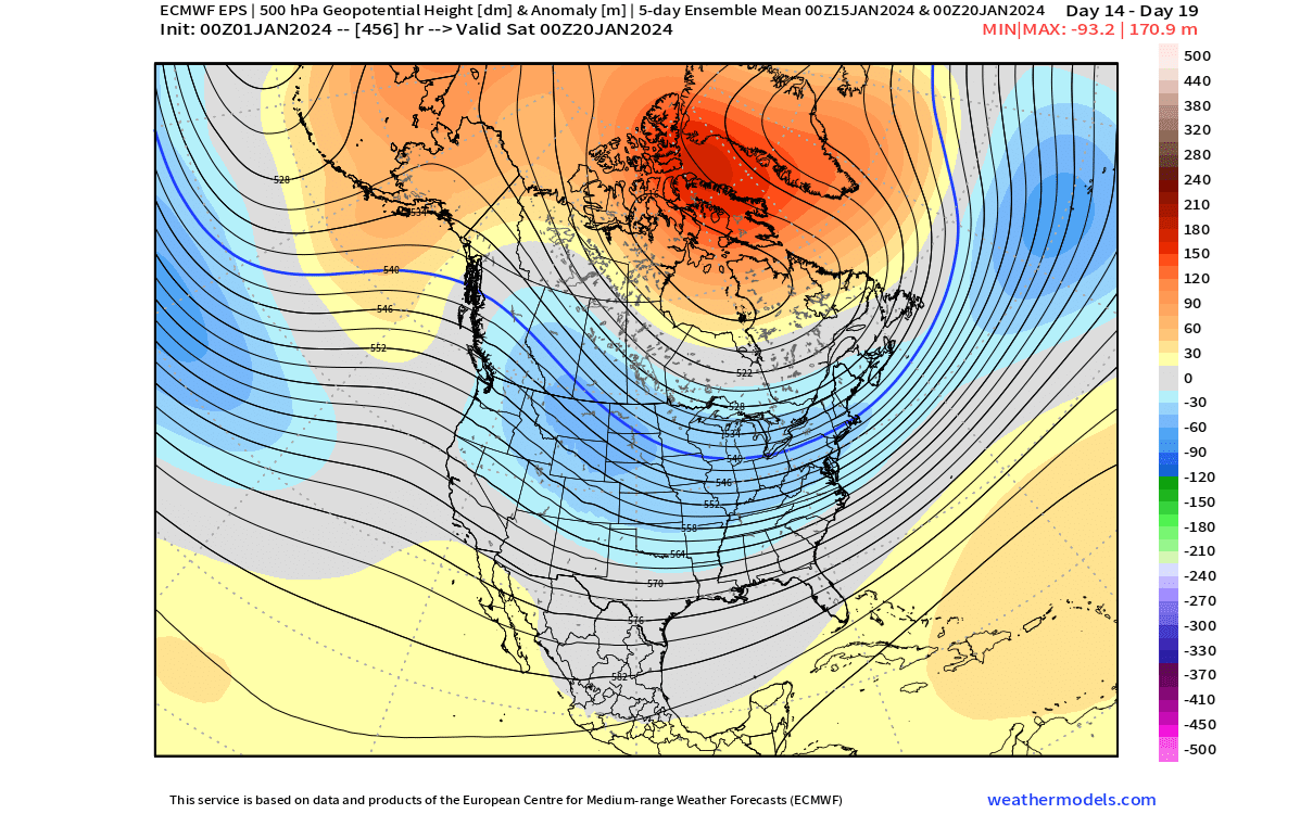
The temperature anomaly for the same period shows the expected cold air across the United States, focused more on the west but expanding to the eastern United States. This keeps the snowfall potential high across the Midwest and over the eastern United States.
But, going into the final days of January, another brief pattern realignment is forecast. In the pressure forecast below, you can see a ridge building over eastern Canada and the eastern United States. Such a pattern adjustment is to be expected but is usually not very long-lasting.
The temperature forecast for this period shows the cooler conditions persisting over the western United States, but warmer conditions return over the Midwest and the eastern United States.

But, as we enter February, the weather pattern progression becomes favorable again. The high-pressure area pulls back to the north, allowing the low-pressure anomalies to return over the United States.
The temperature forecast reflects that shift, allowing cold air to return to the Midwest and the eastern United States. This again raises the potential for snow events over the eastern half of the country and is in line with the historical El Niño impacts we showed earlier.

These forecast maps were provided by weathermodels.com, using a commercial forecaster license.
We will keep you updated on the global weather pattern development, so don’t forget to bookmark our page. Also, if you have seen this article in the Google App (Discover) feed, click the like button (♥) there to see more of our forecasts and our latest articles on weather and nature in general.
Learn more: