A progressive weather pattern has been established across North America, with multiple winter storm impacts for Canada and the United States. Storms Ember and Finn brought blizzards, dumped deep snow for the Midwest, and severe weather along the Gulf Coast. Another even stronger winter storm, Gerri, is shaping up for this Friday and is expected to significantly impact travels with deep snow and blizzard conditions across the nation over the weekend. Then, the most intense Arctic Blast of this Winter Season will spread across Canada and the U.S., pushing temperatures 40 to 60 degrees below normal.
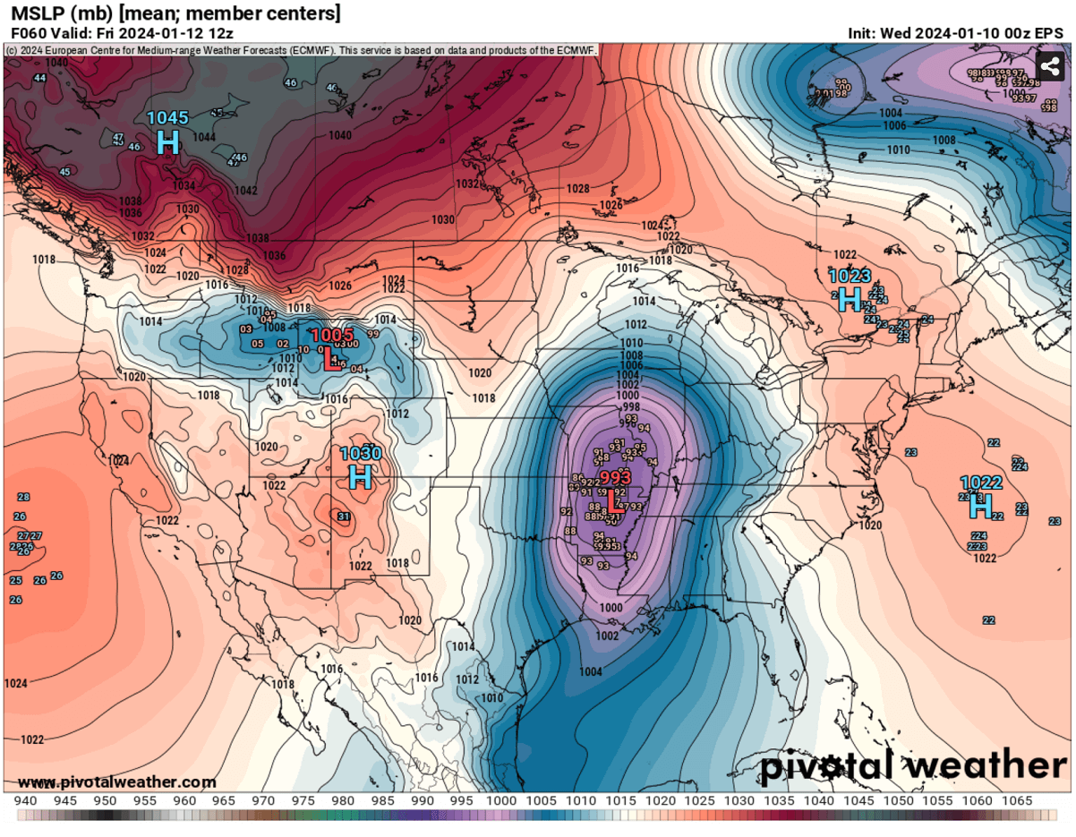
The new system entering the Pacific Northwest has formed along the polar westerly jet streak, emerging from the Pacific Ocean south of Alaska. It will dig southeast across the Rockies and intensify into a Winter storm Gerri Thursday night. Gerri will take almost the same general track as Storm Finn this week.
A significant winter storm development is expected across the Midwest and Great Lakes. A strong pressure gradient will induce severe winds accompanied by heavy snowfall, so many areas will be impacted by blowing snow, blizzard conditions, and reduced visibility. Travels will be arduous to nearly impossible for millions along Gerri’s path.
Conditions will again deteriorate rapidly as the deep upper wave emerges and become dangerous Friday afternoon into Tuesday as storm Gerri intensifies further and tracks east.
Then, the real deal will follow in the wake of the storm as an extensive reservoir of frigid cold air mass will begin its progress from Arctic Canada far south and spread into the United States. Temperatures will plunge into deep freeze, reaching more than 50 degrees F below average for the northern countries.
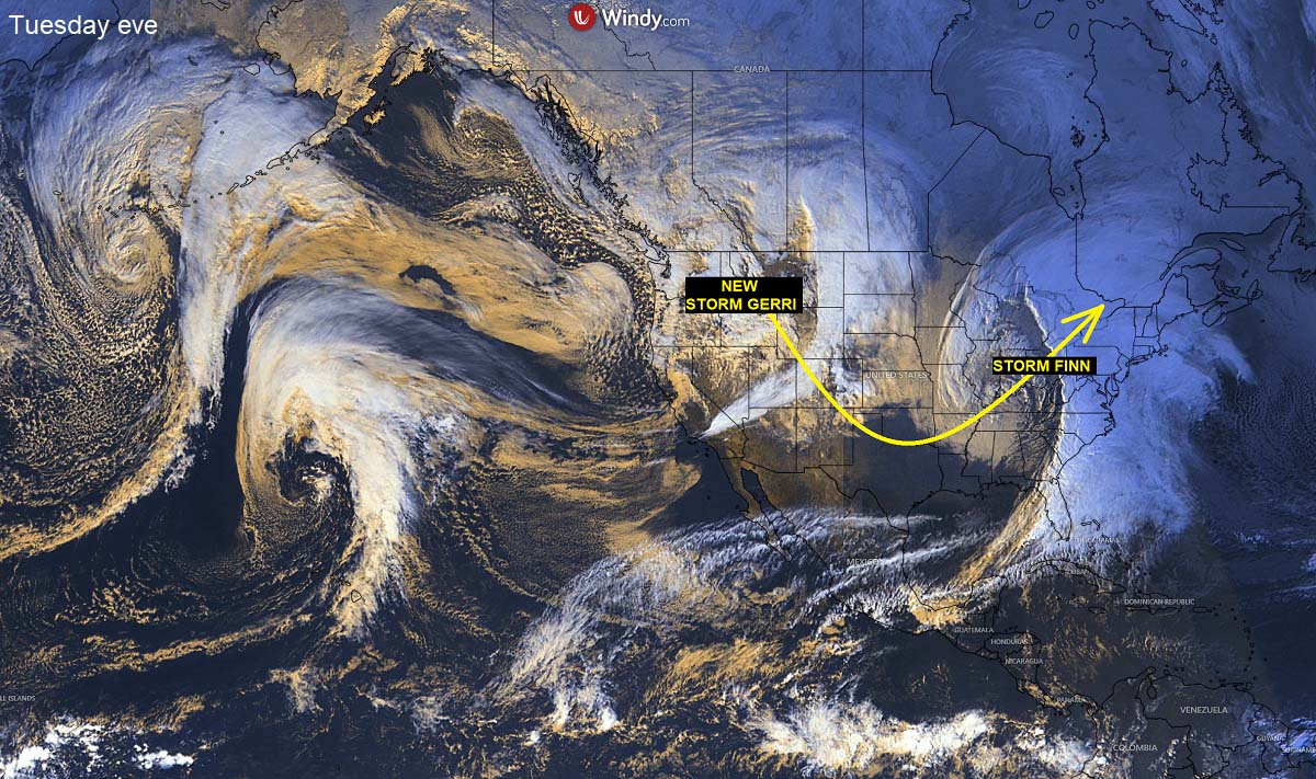
The following satellite image across North America and the Pacific reveals an impressive atmospheric train of waves and winter storms. Frontal systems are entering the United States and Canada from the Pacific Ocean, moving west to east.
Storm Finn is gradually departing Northeast, while the new developing storm Gerri is already organizing across the Pacific Northwest. It is forecast to move southeast into central CONUS, rapidly intensify, and head across the Midwest to the Great Lakes for the weekend.
The gif animation below is a quick overview of the rapidly deteriorating winter storm conditions across the U.S. and Canada over the next 7 days. First, the surface low deepens into an intense winter storm, followed by a major Arctic Blast from the north.
As Gerri will be tracking toward the Northeast for the weekend, a significantly colder, frigid Arctic air mass will begin spreading under the strengthening upper High across North America.
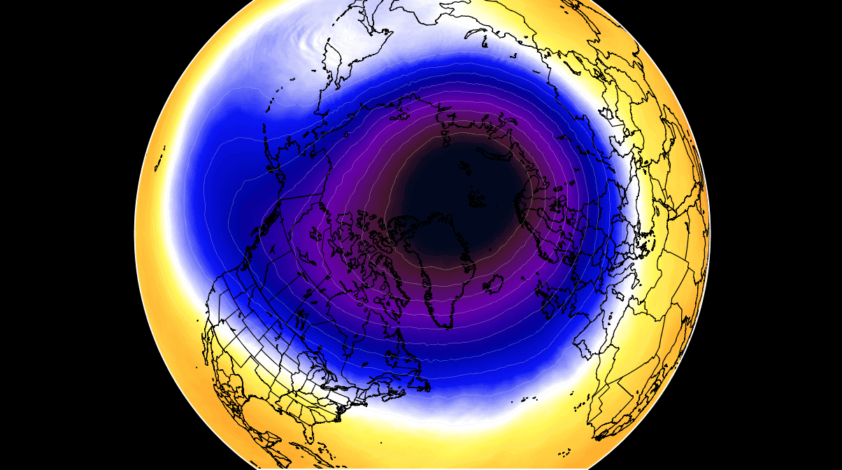
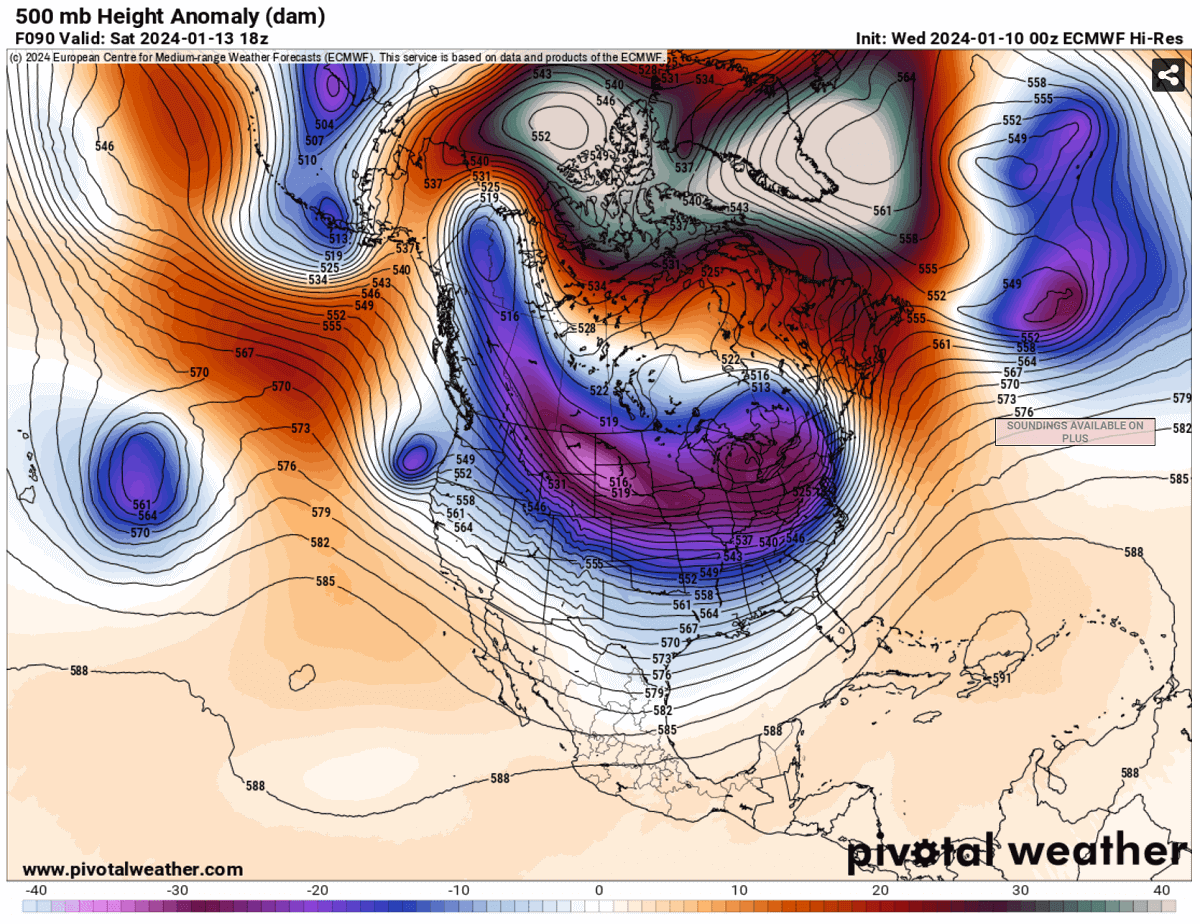
The main trigger behind the upcoming Arctic Blast is the strong disruption of the Polar Vortex aloft. Its southern lobe has shifted over North America this month, and it will be the main reason for the most intense outbreak of the Arctic cold air mass for Canada and the United States this Winter Season 2023/2024.
THE POLAR VORTEX
The Earth’s atmosphere has six layers around the planet. Most of the dynamics for our daily weather occur in the lowest two layers, known as the troposphere and the stratosphere.
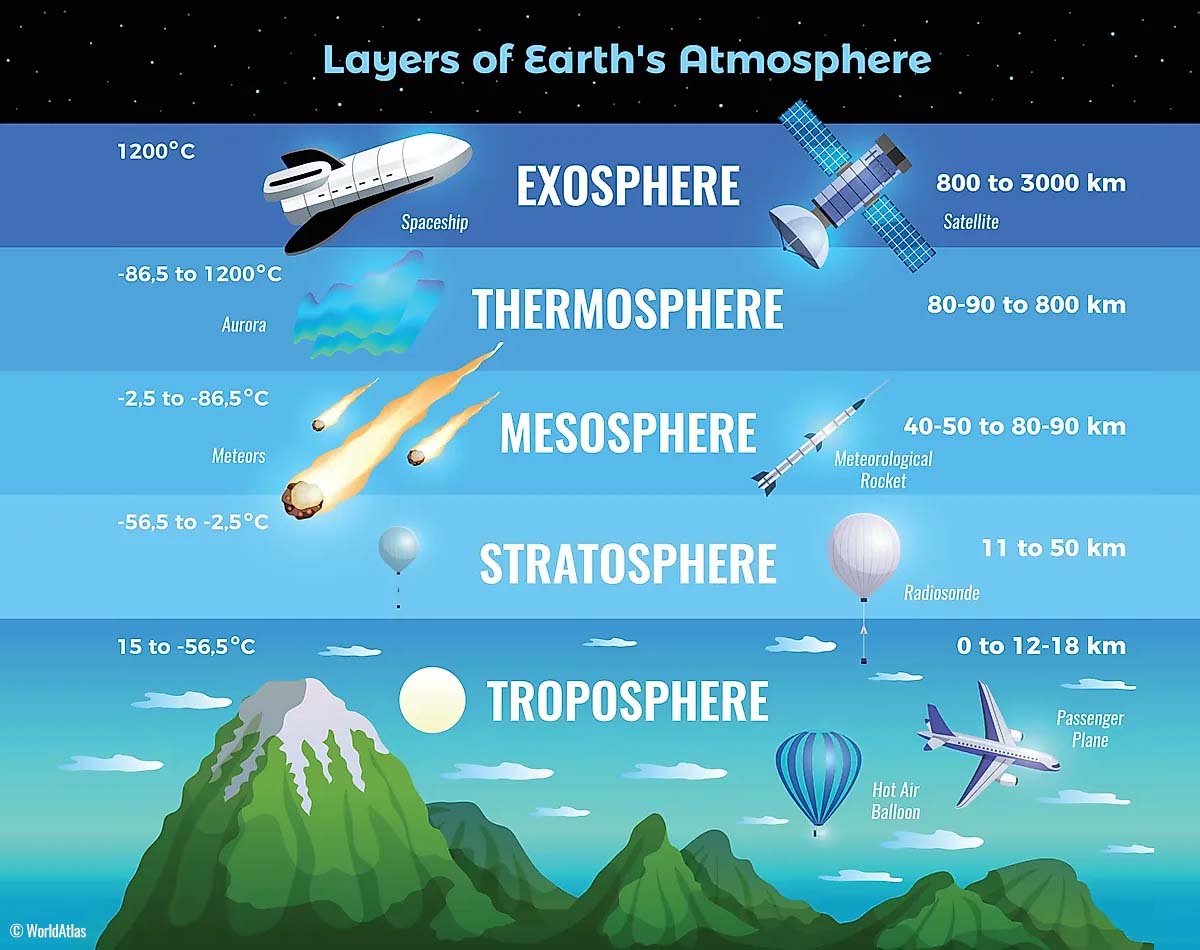
The troposphere is the closest layer to the Earth’s surface; it is about 12 km deep and extends from the ground up high into the sky. The depth of it varies from around 8 km to almost 20 km, depending on where you live. The troposphere is the deepest above the equatorial region and gets much thinner above the North and South poles.
Above this layer is a much deeper one known as the Stratosphere, an 11-50 km thick layer with very dry air. The stratosphere also has the ozone layer, whose vital role is to protect our planet’s life against the potential impact of solar storms from the Sun or outer space.

Another essential feature in the stratosphere, which makes our weather even more variable, often triggers significant large-scale and long-lasting winter weather events. This is the Polar Vortex. An enormous, tri-dimensional ring of powerful winds moving through the sky above us. The Polar Vortex is spinning around the North Pole, grazing through the air at about 20-50 km above the Earth’s surface with violent wind speed.
The troposphere and the stratosphere are crucial for our climate, as the Polar Vortex covers most of the bottom half of the atmosphere. Since the vortex extends from the middle of Earth’s troposphere up into the stratosphere layer, it has the main major effect on the winter weather across the high and mid-latitudes yearly.
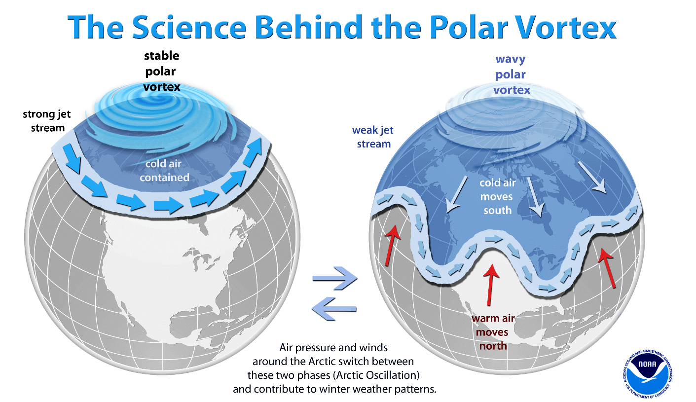
We could experience this in Canada, the U.S., and recently in northern Europe and Asia as the vortex has been significantly disrupted and shifted on the other side of the northern hemisphere, reaching North America.
The Polar Vortex is the strongest during winter in both the Northern and Southern hemispheres. And although it spins well above our heads, it remains closely connected with the lowest parts of our atmosphere. Thus, it leads to our daily weather shape in many different ways, as it generally works as one sizeable hemispheric circulation.
The Polar Vortex has triggered the majority of the most intense weather systems, from the frigid cold outbreaks and winter storms in Canada and the United States to Asia and Europe. It affects the whole Northern Hemisphere, but its main impact mainly occurs where the southern lobe of the vortex is positioned.
How and when does the Polar Vortex form?
Due to the Earth’s inclination, the polar regions receive much less energy from the Sun during the fall months. This way, the cooling over the northern regions becomes more robust. As a result, polar nights also occur for several consecutive months, with days without any sunlight following.
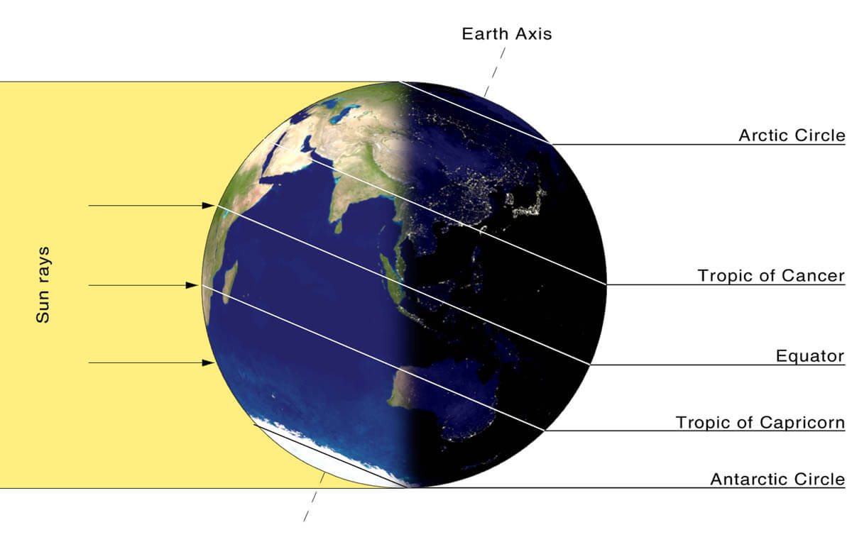
While the temperatures in the polar region are dropping into deep freeze, the atmosphere layers farther to the south are still relatively warm since they receive more of the Sun’s energy simultaneously. Therefore, the south’s equatorial layers remain much warmer than the areas farther north. So this leads to a high-temperature contrast between them.
Cooling the polar regions also lowers the ambient surface pressure, with a similar weather process also happening in the stratosphere layer. The temperature difference between the North Pole and the equatorial areas increases across both layers. This creates a large low-pressure cyclonic circulation across the polar stratosphere, where this feature takes its famous name – the Polar Vortex.
Putting all these puzzle pieces together, the Polar Vortex is an enormous cyclone in Earth’s atmosphere. It expands across the North Pole during winter and sometimes becomes very intense, extending south to the mid-latitude regions. The same is also happening in the southern hemisphere during their winter period when the Polar Vortex intensifies around the South Pole.
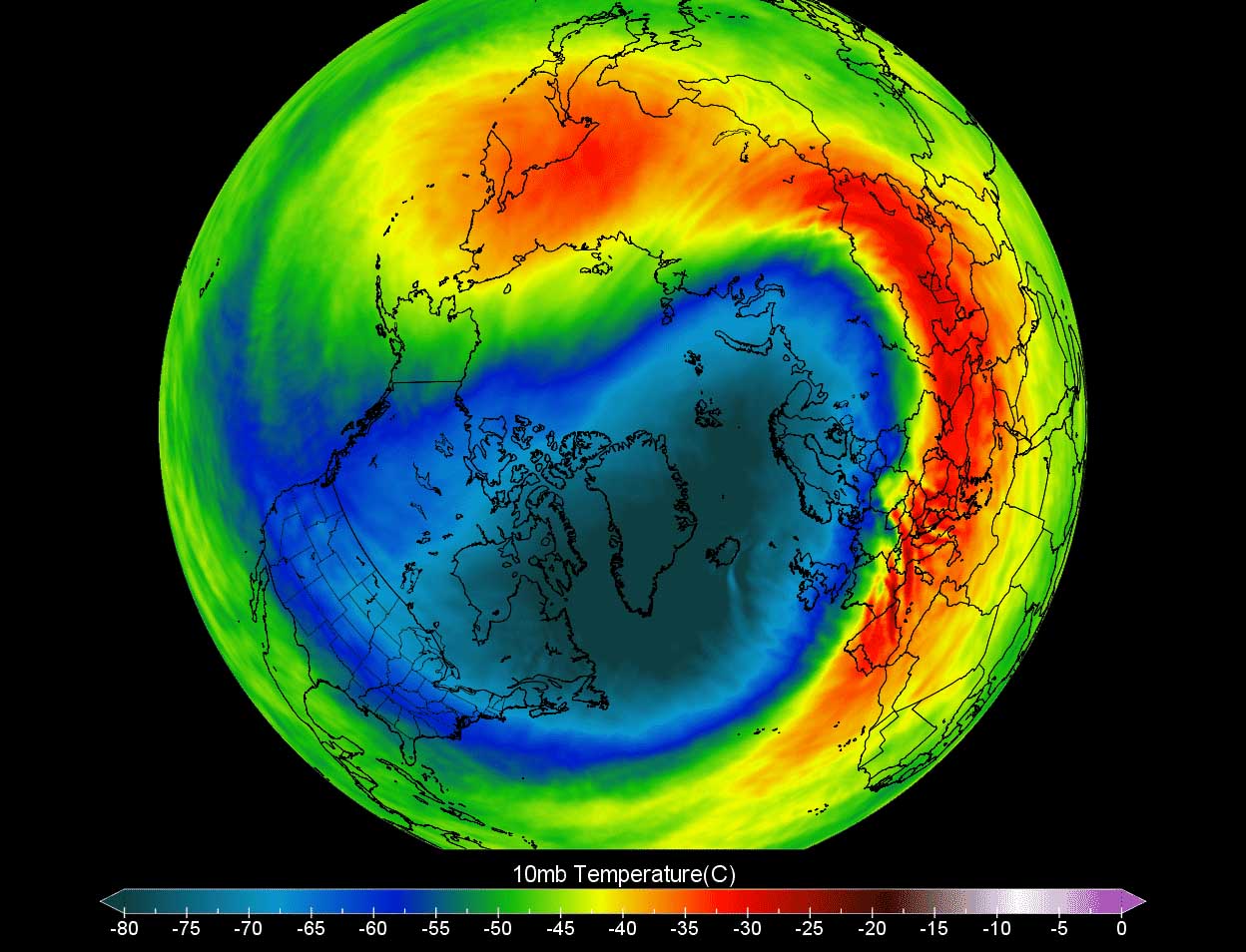
The weather model chart above hints at a typical situation when the Polar Vortex is fully established above us. It represents the pressure at around 30 km (18 miles) altitude, located near the top of the stratosphere layer during winter.
The active and strong Polar Vortex during the Winter season 2023/24 has been the main trigger behind the historic cold outbreaks over Siberia and across Lapland in northern Europe at the beginning of January. Meanwhile, the most intense part of the vortex, the Polar Vortex southern lobe, has now shifted towards the North American side of the northern hemisphere.
Another Deep Upper Wave Emerges Across Canada and the U.S. on Friday
The general weather pattern developed across North America indicates a large-scale, deep upper-level wave emerging south from Canada into the Contiguous U.S. It will deepen and intensify further late this week.
By the weekend, the wave gradually transforms into an upper low and reaches deep South, similar to the most recent wave, which brought Storm Finn to the U.S.
An extensive wave like this one significantly disturbs the upper levels. It will lead to another major winter storm Gerri, across a large part of the Contiguous U.S. It moves far south again, dragging a much colder air mass in its wake, clashing with moist and warm air from the Gulf region.
This results in significant winter weather on the side of the storm and severe thunderstorms on the other. The following weather chart represents the upper-level winds (200 mbar), where we can see a deep wave disturbance southward into the CONUS.

In response to significant high falls in the upper levels, as the wave digs this far south, the pressure will lead to rapid surface cyclogenesis from the southern Rockies towards the Great Plains Thursday night, strengthening further east towards Mississippi Valley on Friday.
The low will pump vast amounts of moisture from the Gulf region toward the surface frontal system. Simultaneously, a much colder air mass moved in its wake from the northern Plains and Rockies towards the Midwest. Thus, the front will intensify with significant weather on Friday.
Heavy snow with rapidly deteriorating blizzard conditions will develop across the Midwest in the rear side of the storm across parts of Nebraska, Iowa, Wisconsin, and northern Illinois, including Chicago, by midday Friday.
Blizzard conditions will rapidly worsen with time as the system continues deepening its central pressure and intensifying further on Friday afternoon towards Saturday.
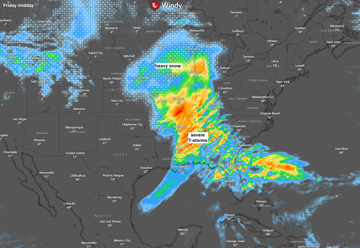
Ahead of the cold front, a large warm sector will again produce thunderstorms with potential severe weather, including heavy rainfall, tornadoes, and flooding across the Southeast U.S. and East Coast. With the activity fast-moving east.
A swath of multiple rounds of storms will result in vast rainfall over central Florida, the Mid-Atlantic, and New England late this weekend.
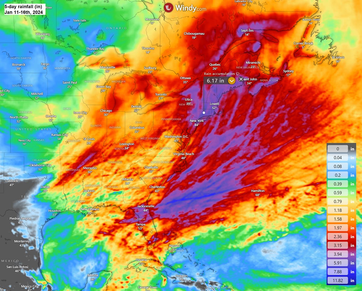
An additional 6-8 inches could accumulate in some areas, leading to returning flooding potential, precisely over Florida, coastal Carolinas, and most of the Northeast U.S.
Explosive Development of Winter Storm Gerri Blasts Midwest and Great Lakes with Heavy Snow and Blizzard on Friday into Saturday
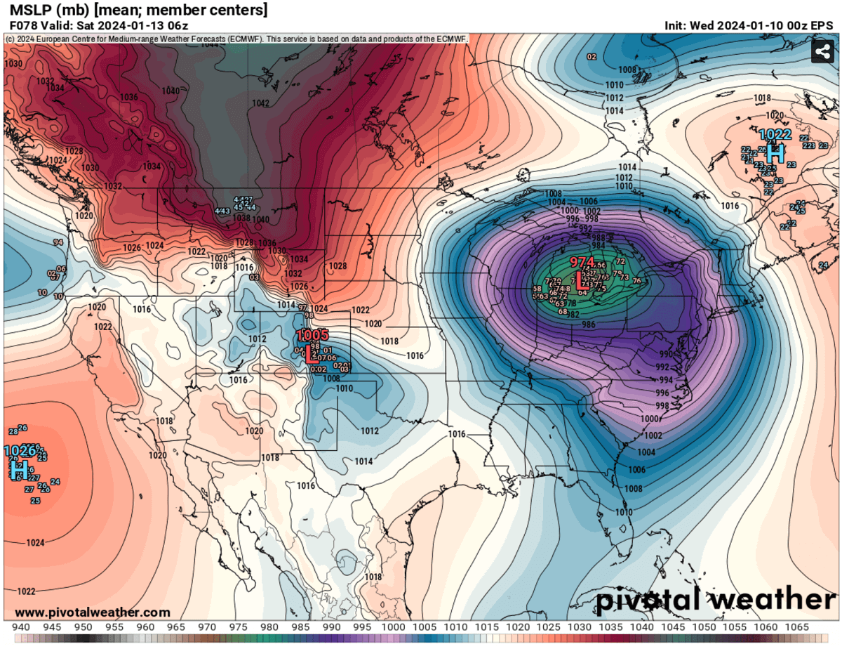
As the weekend approaches, the upper wave will eject the front-end core into a cut-off low towards the east. The chart below shows the parent deep core over the Northwest U.S., with the other core ejecting into Eastern CONUS.
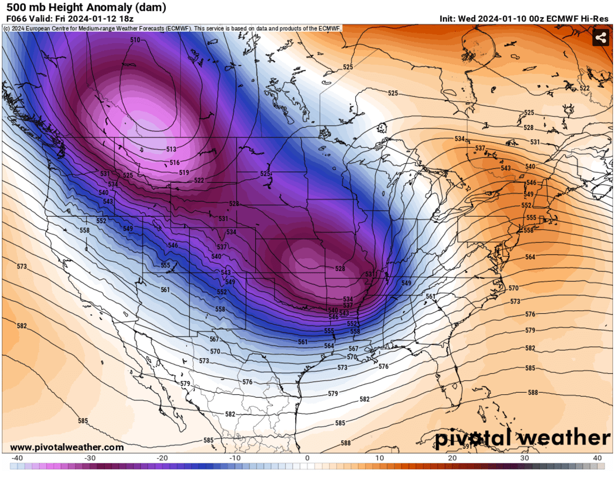
Once this wave cuts off the primary deep upper wave and moves more south/east, it taps into subtropical air. This intensifies the surface low and turns towards the Great Lakes. With a strong jet stream rounding the base of the upper core, the development of the surface disturbance will be rapid.
Pressure should drop to below 975 mbar by Saturday morning.
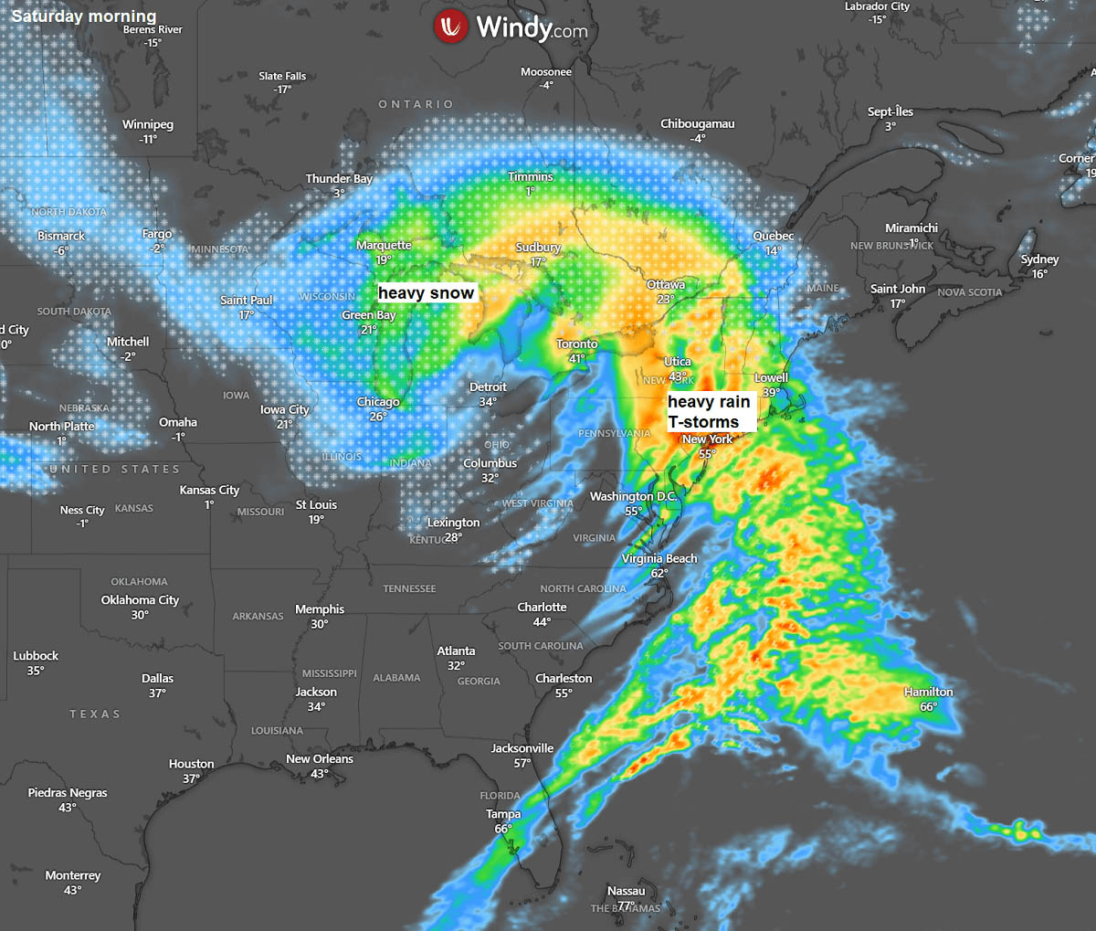
The following chart indicates the position of the frontal system on Saturday morning.
The wide swath of heavy snowfall with blizzard conditions will spread across the Upper Midwest, becoming intense towards the Great Lakes.
Also, there will be widespread thunderstorms, some severe, along the leading front extending from the Mid-Atlantic southwestwards across the Southeast U.S. and Florida on Saturday, moving east.
The amounts of snow near the core of storm Gerri will be significant, as the interaction of the moist southerly air mass and cold Arctic air mass from the north will be sharp. A swath of snow with 15 to 30 inches accumulated will be possible from eastern Nebraska and Iowa to Wisconsin, northern Illinois, and Michigan into southern Ontario, Canada.
Note that the exact position of the front may vary, depending on the development of the surface low. A minor difference in the front position would significantly affect the location of the heaviest and most abundant snowfall.
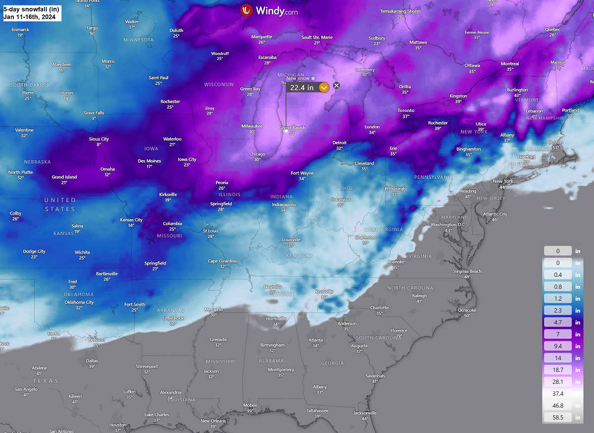
Nonetheless, the most significant snowfall will be along the northern edge of the strengthening surface low as it tracks northeast from Friday morning through Saturday. Intense blizzard conditions will develop with strong to severe winds within the sharp pressure and temperature contrast.
This will significantly reduce visibility, with whiteout conditions likely to be expected. Roads across the Upper Midwest and Great Lakes may become impassable with major travel disruptions on Friday midday and Saturday.
The following chart of peak winds from Thursday through Monday next week indicates strong to severe winds will develop across the Eastern U.S., precisely along the moving front from Southeast to the Northeast and New England.
Strong winds can also be seen over the Lakes, meaning blizzard conditions will be intense.
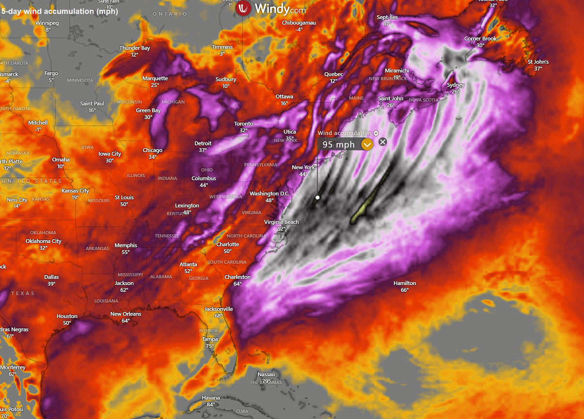
Peak gusts could reach 70-80 mph. The strongest gusts will likely develop off the Atlantic coast.
Significant Arctic Outbreak with Frigid Cold Air Mass Follows Behind the Winter Storm Gerri
The Winter Storm Gerri will rapidly eject the Great Lakes into Eastern Canada Saturday night when the pattern wave will re-intensify in the upper levels over Canada and the northern United States. There is now great weather model consensus that a significant Arctic cold outbreak will develop and spread across most of North America.
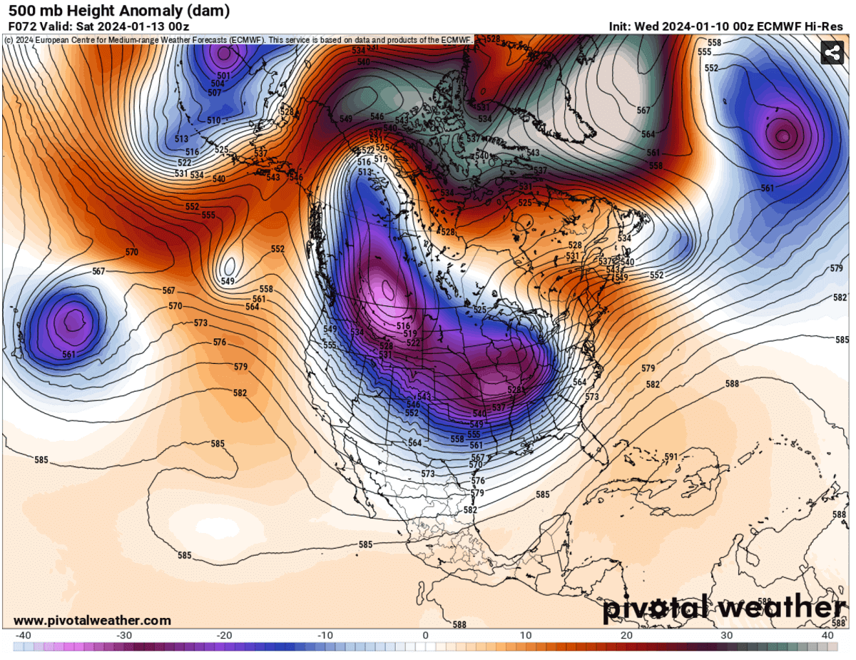
The following chart for North America hints at this large upper wave/low re-developing on Saturday and Sunday, with a significantly deep core. This is usually a sign that a mighty Arctic cold will follow.
The upcoming Arctic Blast will bring the most intense cold weather this Winter Season 2023/2024.
The cold outbreak is forecast to gradually intensify on Thursday across western Canada, spreading into Idaho and Montana Thursday night. A significantly colder Arctic air mass spreads into the North and Northwest United States from Friday into the weekend and next week.
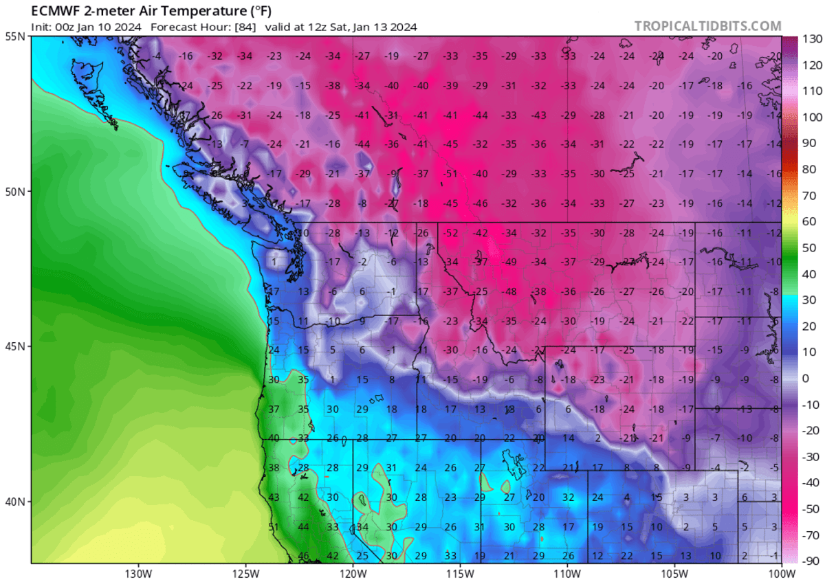
By Saturday morning, the temperature will plunge into frigid low numbers, with an impressive temperature anomaly across the Northern Rockies and Canadian Prairies. The chart below hints at these ‘off the charts’ anomalies, pushing to more than 30 °C below average at the 850 mbar level.
The cold also gradually spreads east and south into north-central U.S. on Saturday and continues on Sunday, reaching eastern Dakotas and central Plains by midday Saturday.

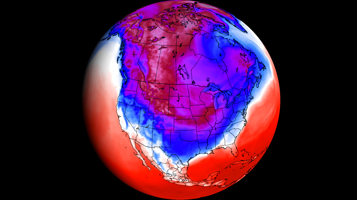
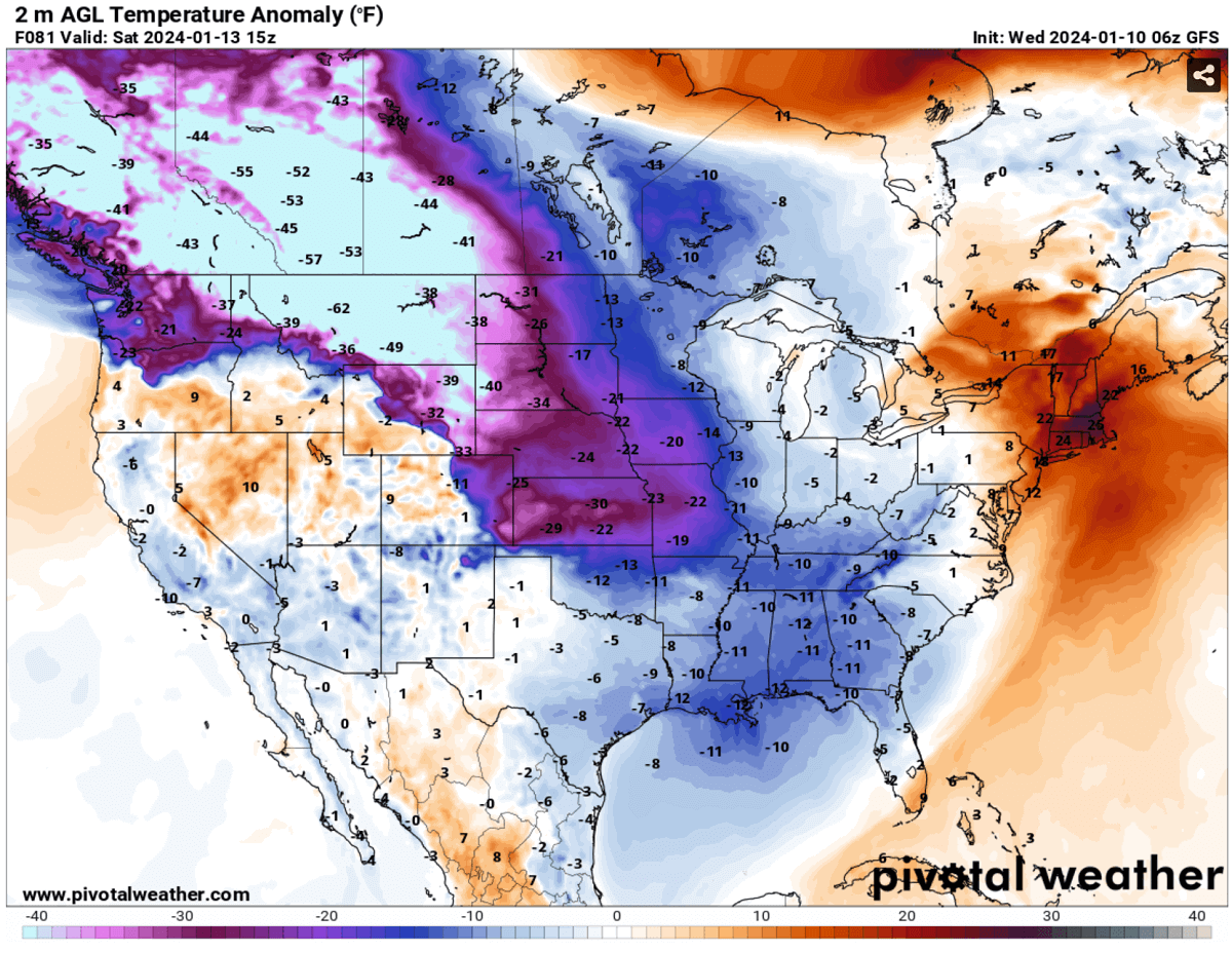
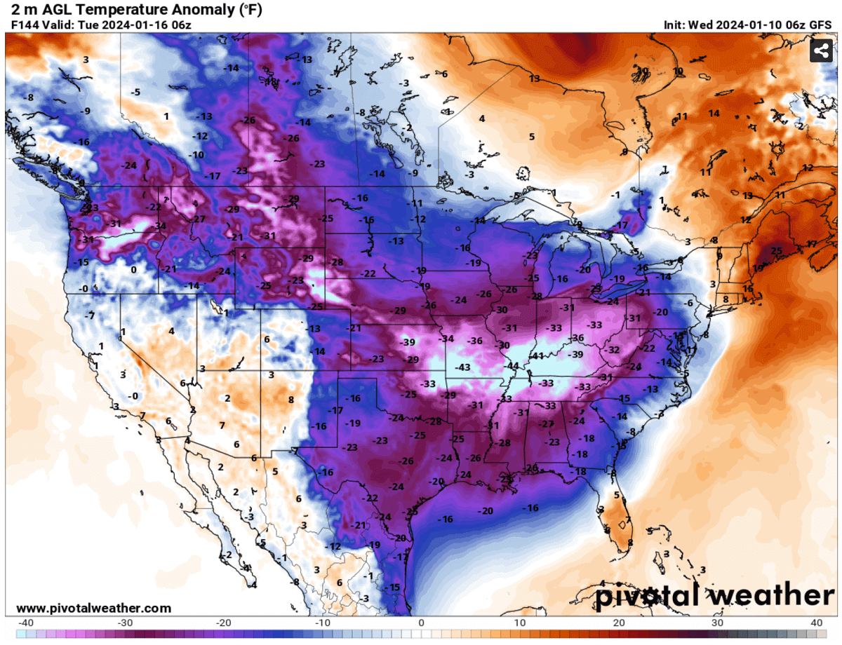
The Arctic cold pool will remain until early next week after the weekend. The below chart represents the 2-meter temperature anomaly for Monday morning, Jan 15th. Temperatures across Montana and further north into British Columbia and Alberta are forecast to be extremely low. About 50 to 65 degrees F below normal.
This results in particularly dangerous, frigid cold conditions for southern Canada and the northwestern U.S. states from Saturday through at least Monday and Tuesday.
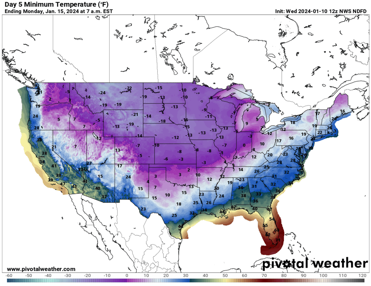
Temperatures on Saturday and Sunday through Tuesday will have daily low temperatures into the mid-40s to nearly -55 °F (-48 °C).
Temperatures will remain far below freezing, around 20-30 °F below average also during the daytime hours.
On Monday morning, temperatures across much of the United States will be below freezing except the Gulf Coast, Florida, and the southern West Coast.
Areas to the north of North Texas, northern Arkansas, and central Ohio Valley will experience morning temperatures below 10 °F, with negative values further north, around -10 and -20 °F across the northern Plains and Midwest.
Due to the extremely deep Arctic cold pool, there will not be much warmer even during the day. Temperatures will only get back above freezing in the desert Southwest, southern Texas, Southeast U.S., and the East Coast.
Elsewhere, the deep freeze will remain on Monday, continue into Tuesday, and likely Wednesday.
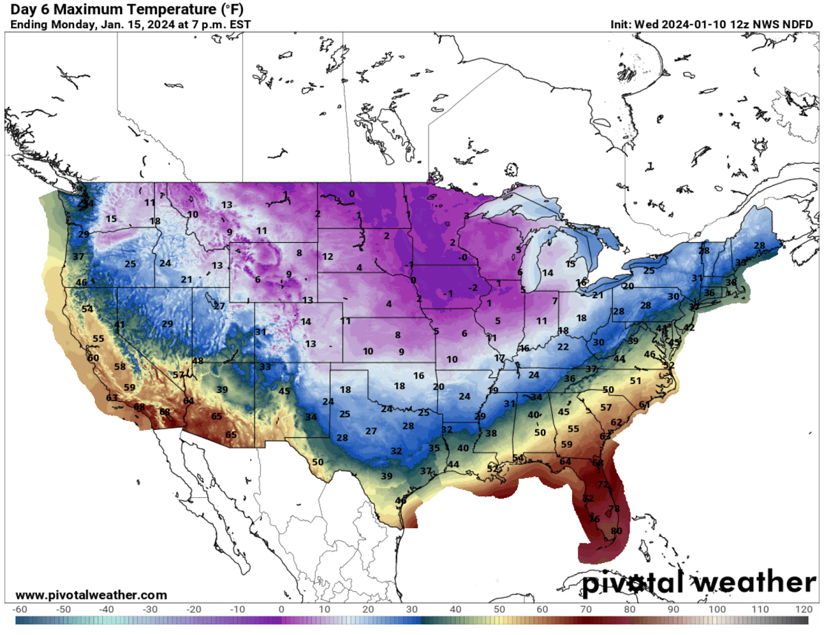
Daily temperatures will remain in single digits across Central Plains and Midwest. Near 0 °C or even below across the Northern Plains and the Upper Midwest.
The cold pool will be parked nationwide for multiple days next week. Thu, from Tuesday into mid-week, the core of the Arctic outbreak will likely push into the Eastern U.S. as well.

Attached below is the 2m temperature anomaly on Tuesday. A large part of the United States will be in extreme cold. The temperature anomaly is the most significant across the eastern two-thirds of the country.
Temperatures will be 30 to nearly 45 °F below the average from Kansas and Oklahoma across the Mississippi Valley to Ohio Valley on Tuesday.
Cold will also reach deep South and the Gulf Coast after Monday. With temperatures 15-25 °F below average also on Tuesday.
The long-term projections hint that the Arctic cold will likely persist through mid-January.
There’s also a rising potential for another winter storm sometime next week, but the forecast is too far ahead to give any specific details. We are closely monitoring the ongoing pattern evolution and will update accordingly – stay tuned.
Wxcharts, Windy, and Pivotalweather provided images used in this article.
See also: