January 2023 brought quite some wintry weather, with two major winter storms and a lot of snow in some areas. This weekend and into the final days of the month next week, a significant Arctic cold will plunge deep south across North America. Frigid low temperatures will spread from Canada into the northern half of the United States first, then towards Great Lakes and Northeast as we move into early February.
More snow is forecast from the Rockies to Midwest, resulting in icy road conditions. Additionally, another rather intense lake-effect snow event will likely follow over the Great lakes, Erie and Ontario, in particular mid-next week.
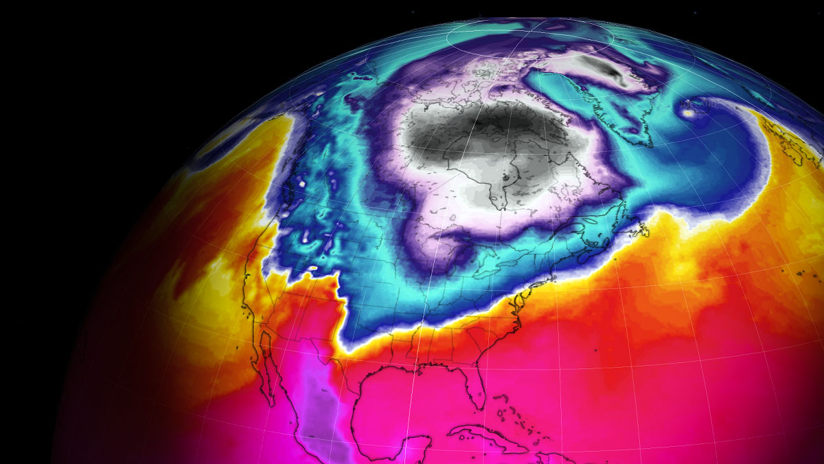
From the record warmth earlier this January, more seasonably cold weather for a large part of southern Canada and the U.S. followed. This weekend, the next pool of particularly cold airmass from the Arctic arrives. Meanwhile, the Polar Vortex aloft is rapidly weakening, as discussed earlier this week in one of the articles.
The NSIDC satellite analysis of snow cover across North America below reveals the impressive swath of snowpack across the continent. This was deposited with the most recent winter storms over the last two weeks; Jimenez and Kassandra traveled across the Contiguous central U.S.
And quite a significant amount of snow was spread from the central Plains across Midwest and Upper Ohio Valley and further into the Northeast U.S. A huge snowpack has resulted.

The thickest snow depth is across the Rockies, with Sierra Nevada drowning in historic snow this winter season 2022/23. Persistent moisture deposited vast amounts of snow triggered by the atmospheric river of snowstorms from the North Pacific.
Meanwhile, the main feature running out Winter weather from the stratosphere aloft, the Polar Vortex circulation, has been very powerful throughout the first half of the season. It is now in a rapid weakening phase and collapsing. Lower in the troposphere, major changes in the general weather patterns across North America suggest they will soon develop another powerful Arctic cold outbreak. They are plunging from Canada into the United States.

It has already started cooling over the North, with temperatures well below freezing across High Plains and Dakotas to Minnesota. A large pool of extremely cold air over west-central Canada is gradually sliding south while intensifying. The deep freeze will leave North Dakota and Minnesota with temperatures more than 30 degrees Fahrenheit below average with much lower (below -40F) wind chill.
This weekend, the developing large cold pool will intensify over Canada, spreading into the northern tier of the U.S. after Sunday. A dipole weather pattern with a High on the West and a deep Low on the east hints at the more meridional north-northwesterly flow to establish. The ideal recipe for significantly colder weather is to push farther south across the continent.
The video animation above reveals the spread of the Arctic cold temperatures from central Canada into the Northern U.S. over the weekend into early next week. A strongly anomalous air cannot be missed. Days will be *much* colder than experiences until now this January.
Let’s detail the pattern evolution and potential impacts of snow, ice, and frigid cold as the charts hint at the most intense cold of 2023.
ARCTIC BLAST BRINGS THE COLDEST AIR OF JANUARY 2023 TO THE NORTHERN STATES
Once again, a textbook dipole weather pattern is established across the northern Pacific and western North America, with a deep upper trough to its east. This will help to bring frigid cold airmass from Arctic Canada into the U.S. through the final days of January. It extends into early February 2023 over the Lakes and Northeast U.S.
With blocking High strengthening across the western portions of the continent, the deepening upper Low over interior Canada sends a new intrusion of Arctic air mass into the U.S.
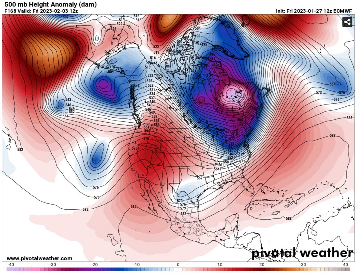
Generally, a high surface pressure develops under such a strong blocking High aloft. The surface High will cover much of western Canada and the United States. The lower pressure under the core of the Polar trough to its east helps to create a stronger pressure gradient. This, in other words, increases the winds in the channel between the two features.
The following chart hints at particularly large pressure over the Northern Rockies on Monday, sending air toward the U.S. from the north.

These enhanced winds lead to a massive transport of much colder, frigid cold, Arctic air mass from central Canada between these two large-scale features. Plunging towards the northern and later into the eastern part of North America, with south-eastern Canada and North-Northeast U.S. in the core of this blast.
The much colder than normal Arctic air mass will push east-southeastward from central Canada prairies from mid-Saturday into Sunday and continue towards the Lakes in the early days next week. It will put these regions from the Northern Plains across the Great Lakes to the Northeast U.S. into a deep freeze.
The cold pool will be the coldest of 2023 so far for southern Canada, northern and northeastern U.S. Also for the areas around the Lakes, Ohio Valley, Appalachians, and the Northeast U.S.

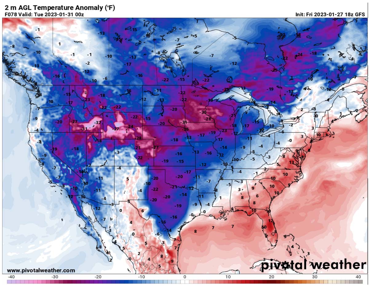
Morning temperatures are forecast to dip to around -20F from Sunday to Tuesday across the north, spread into the Great Lakes through Tuesday night into Wednesday. It has not been as cold yet this month in this part of the country.
Sub-zero °F temperatures for several days are forecast across North Dakota and northern Minnesota, combined with breezy winds and blowing snow.

After Tuesday, the cold air advances further into the Northeast and New England, with temperatures reaching single digits and towards 20F below across the international border on Canada.
Morning temperatures will gradually plunge into single digits from the Upper Midwest to the Lakes and further Northeast from Tuesday through Friday and Saturday. As the below chart indicates, the air mass will be even more than 30 degrees F colder than usual for many. The cold will also spread deep south towards Oklahoma and Texas on Monday.
We often use the Meteogram charts to understand better how anomalous are the temperature forecasts when a significant Arctic outbreak occurs. The chart below shows the Meteogram for Montreal, Canada, and Boston, US, revealing that the new Arctic blast will be very strong.
While the Northeast U.S. is currently at around normal temperatures for this time (-7 °C or 20 °F), a temperature drop of around 30 °F (25 °C) occurs with the Arctic blast emerging from Ontario into the Northeast.

Both charts also show that the cold will extend into early February as the channeling flow from the Arctic will last a week. The long-term normal temperature at 850 mbar level (approx. 1300-1400 meters above sea level) is around 20 °F (-7 °C) during late January and early February.
Temperatures should return to normal values by a late-next week or even later.
MORE SNOW FOR THE MIDWEST, THEN INTENSE LAKE-EFFECT SNOWFALL ALONG THE LAKES OF ONTARIO AND ERIE
A swath of snow is forecast along the Arctic front from Sunday through Monday. Higher moisture should contribute to heavy snowfall across the northern Rockies first, then gradually moving into the Midwest as the front progresses east early next week.
4-8″, possibly up to 10″ of snow will be possible from Wyoming across northern Nebraska to Iowa. Then, the Arctic front arrives over the Lakes on Wednesday, with fresh snow developing.

During the winter, the very cold air masses travel from Arctic Canada towards the southeast, spreading across the Great Lakes frequently. This effect cools down the lake’s water and leads to freezing. So far, this season hasn’t happened yet on a large scale, as NOAA reported, as the significant cold to cool down the lakes was missing.
Although Lakes had an Arctic blast in December, the one that brought historic lake-effect snow to Buffalo, warmth later through early January prevented the ice cover from persisting over the lakes.
The lakes measure only about 4.7 % of the total ice coverage as of January 26th. This is low for mid-winter month.
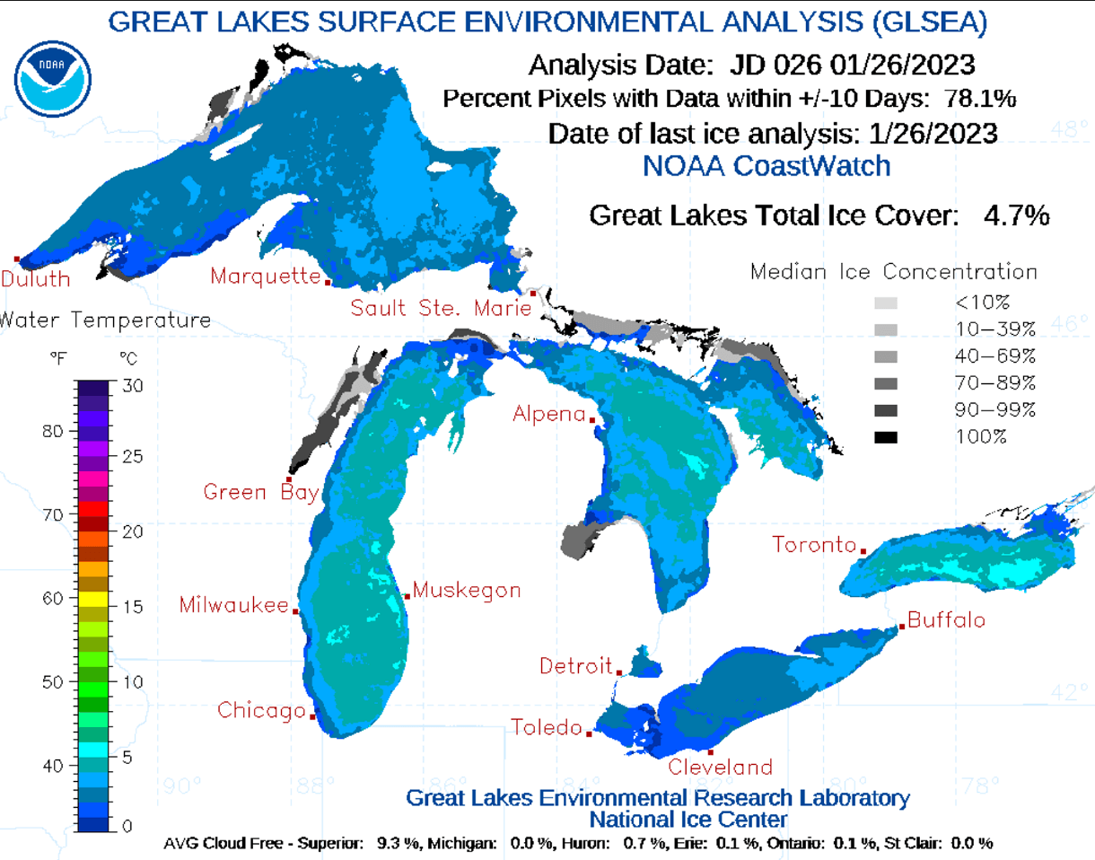
Until the ice coverage doesn’t fully increase, the Arctic cold blasts from Canada are expected to develop intense lake-effect snow across the Great Lakes. The reason is that the more ice-free the Lakes waters have, the higher the potential for lake-effect snowfall.
The lake-effect snow is common across the Great Lakes region during the late fall and mid-winter months until lakes freeze in larger areas. It occurs when cold air, mainly from the deep Canadian Arctic, moves across the waters of the Great Lakes.
When the cold air mass moves over the unfrozen and always warmer waters of the Great Lakes than the coming air, its warmth and moisture are transferred into the lowest portion of the atmosphere above it. The air rises, and clouds form, forming a narrow band(s). This leads to heavy snow bands with 3-5 inches of snowfall rates or even higher.

The key component in this process is the wind direction, the lakes’ water temperature, and the intensity of the cold above it. All these ingredients determine which areas will receive the strongest lake-effect snow. The heaviest snowfall typically occurs in very narrow bands and snow squalls. We rarely experience snow falling in one location while the sun may be shining just a mile away in either direction of the band.
Remember, a historic blizzard with extremely cold temperatures and intense lake-effect snow occurred for the Christmas holidays in 2022. Buffalo, NY, was buried in deep snow and snowdrifts, with hundreds of people and vehicles stranded across the city. Several feet of snow accumulated off the lake, fresh snow coming off lake Erie.
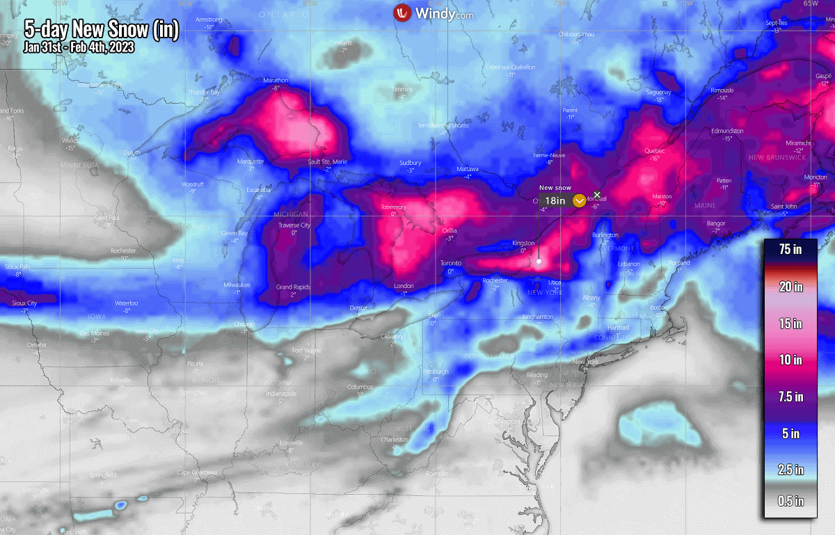
The direction of this new blast of frigid cold northwesterly winds over the Great Lakes should put areas south and around Buffalo and Watertown, NY, into the highest impact late next week. 20-30 inches of snow will likely accumulate by the next weekend.
More snow is also expected across southern Ontario and farther east areas. Close to 10-15 inches (30-50 cm) across part of New England as well.
Additionally, the frontal system sweeping through the Northeast mid-next week could also bring some risk for a few hours of icy conditions from the central Appalachians and part of the Ohio Valley. Ice accumulations are not forecast to be particularly thick, but road conditions will worsen significantly once it occurs.

When proper conditions are met, freezing rain develops. This typically happens when the layer of freezing air is so thin that the raindrops don’t have enough time to freeze before they reach the surface. Instead of the droplets transforming into snowflakes or sleet/graupel, the water freezes in contact with the surface.
Thus, creating a coating of ice on whatever the raindrops come into contact with.
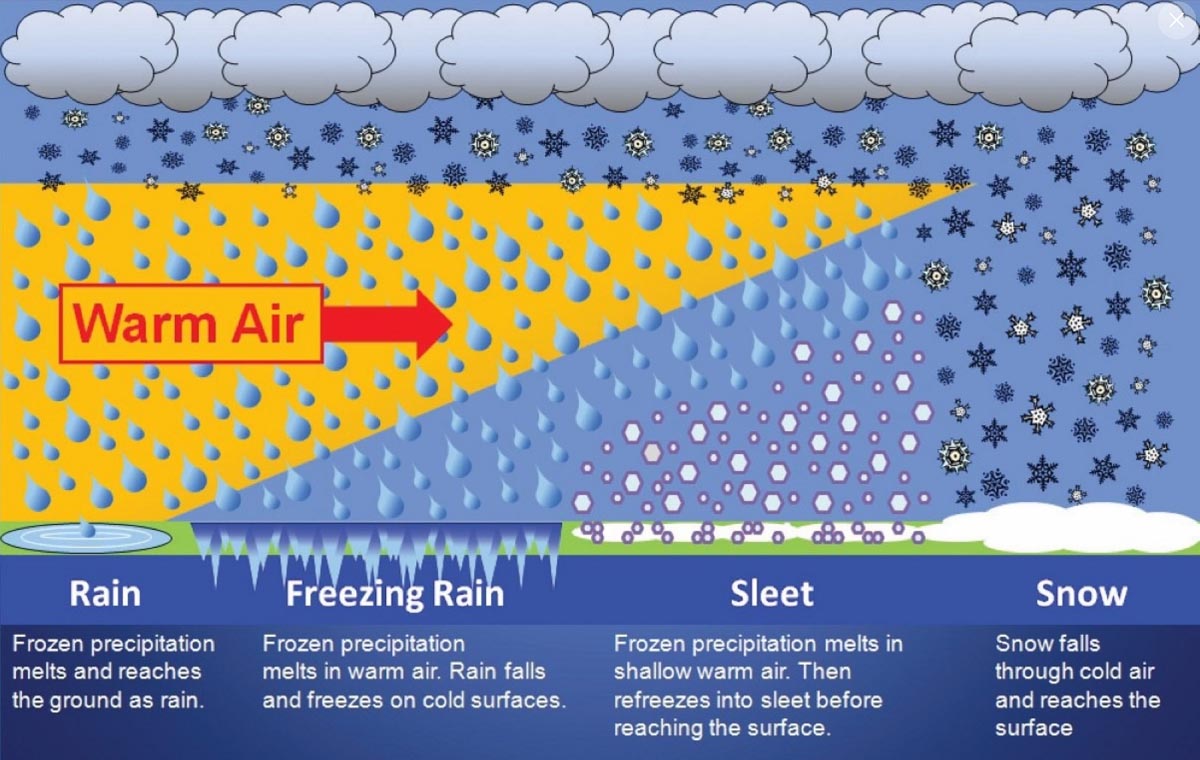
Although the amounts of freezing rain are not forecast to be particularly big, even minor freezing rain and icing events can still lead to bad driving conditions and impact travel with delays, causing accidents.
Stay tuned in the upcoming weeks as we will continue covering the most extreme weather events across North America when Canada and the United States have the potential to be impacted by additional cold blasts from the Arctic.
Images used in this article were provided by Windy, Pivotalweather, and Wxcharts.
See also: