Spring season 2023 is nearing, with forecasts revealing the jet stream pattern over the North Pacific and the Atlantic to be influenced by the diminishing La Nina. A high-pressure system in the Pacific will define the weather patterns over North America, with a potential Stratospheric warming event playing a role early in the season.
The cold ocean phase in the equatorial Pacific is already in breakdown mode. It is expected to decline rapidly towards early Spring.
But, despite the breakdown of these cold ocean anomalies (La Nina), its influence can still persist in global weather circulation. Long-range weather calculations also see this, extending the La Nina jet stream pattern from Winter into Spring 2023.
WINTER SEASON ONGOING
The meteorological Winter season covers the December-January-February period. We are already past the first two months, so we have now entered the last month of the meteorological Winter season.
Below is the temperature anomaly analysis for the United States and southern Canada. The period covers December and January. You can see mostly above-normal temperatures across mainland Europe. However, above-normal temperatures prevailed over the eastern half of the United States and Canada.

This, of course, does not mean there was warmer than normal weather all the time. We all remember the record-strong cold air outbreak across the United States in December. But most of the time, the temperatures were higher than normal, which prevails in the final average picture.
Below we have the same December-January average but for pressure anomalies. A strong blocking pattern dominated the northeastern United States, eastern Canada, and southern Greenland. At the same time, you can see a high-pressure area in the North Pacific related to the La Nina and overall high pressure across the Arctic region.

A low-pressure system was present in the western United States, bringing heavy precipitation to California. However, it was situated further south than usual for a La Nina winter due to strong high-pressure blocking over Canada and Greenland.
Looking at the snow analysis below, we can see areas with more or less snowfall than normal. This shows a more typical La Nina pattern, with more snowfall in the western and northern United States. The total snowfall anomaly for the season is 91%, which is below the long-term average (100%).

FINAL WINTER MONTH
We will quickly examine the latest forecast for the last winter month. For February, a strong high-pressure system in the North Pacific is forecast as the main driver of the North American weather regime. As a response, low pressure remains over Canada, bending the jet stream down over the northwestern United States and into eastern Canada.
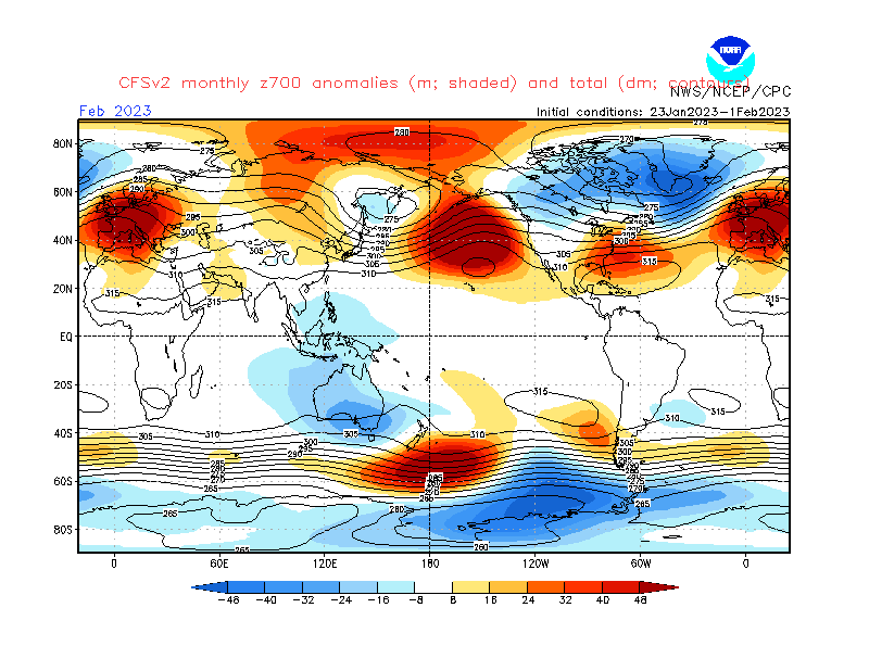
You can also see a broad low-pressure area over Greenland and the North Atlantic. That enables a strong high-pressure system to advance over Europe.
Looking at the surface temperature probability forecast over Europe, we see a warmer pattern. Most of the continent is in the warmer temperature range. However, average temperatures are more likely over the western/southwestern parts, as the month begins with colder than normal weather.

Over Noth America, the latest monthly forecast for February shows colder surface temperatures over most of western Canada and the western United States. Warmer than normal temperatures are forecast over the eastern half of the United States, with stronger warm anomalies over the southeast.
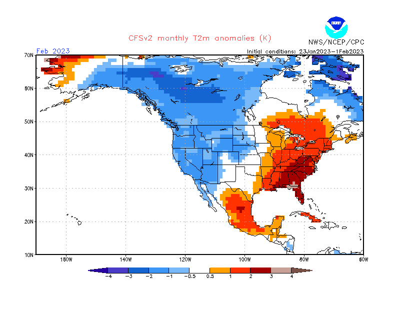
This looks much more like a typical La Nina pattern, with colder air more focused over the northwestern United States and over parts of the west.
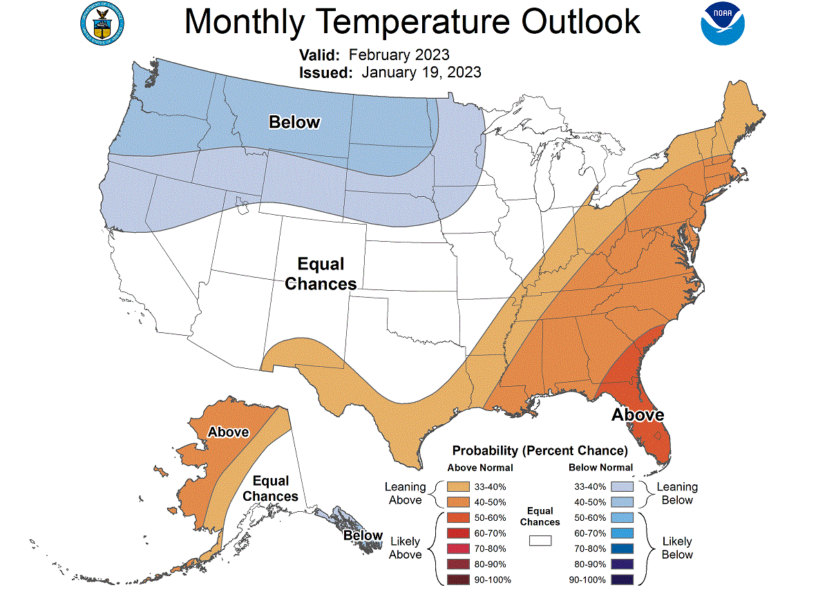
The official NOAA outlook also shows a similar forecast for February across the United States. Again, below-normal temperatures are focused on the northern and northwestern United States. But over the southeast and the east, we can see above-normal temperatures.
The precipitation forecast shows more precipitation over the northern half of the United States. That also means more snowfall in the northwestern parts and the upper Midwest. The deep southern United States is expected to be mostly drier than usual.
But what is driving these Winter patterns, and how will it impact the Spring weather season in 2023?
OCEAN AND SEASONAL WEATHER
One of the main large-scale drivers of this cold weather season is the La Nina event in the tropical Pacific Ocean.
In the image below, you can see the latest ocean temperature anomaly across the Pacific. Notice the colder than normal surface waters in the tropical Pacific regions. That is a La Nina event, spanning far across the equatorial Pacific Ocean, powered by the trade winds.

The presence of a cold La Nina has been the key feature in weather development since late Fall and will continue into Spring.
A La Nina is just a different name for cold ocean temperatures in the tropical Pacific ocean. The actual ocean-atmosphere system is called ENSO (El Niño Southern Oscillation). This region in the tropical Pacific Ocean alternates between cold and warm phases.
In the image below from NOAA Climate, you can see a typical circulation pattern during a cold ENSO ocean event. Air descends in the eastern Pacific, creating stable weather conditions and high pressure. In contrast, air rises in the western Pacific, causing lower pressure, frequent storms, and a lot of rainfall in the western Pacific.
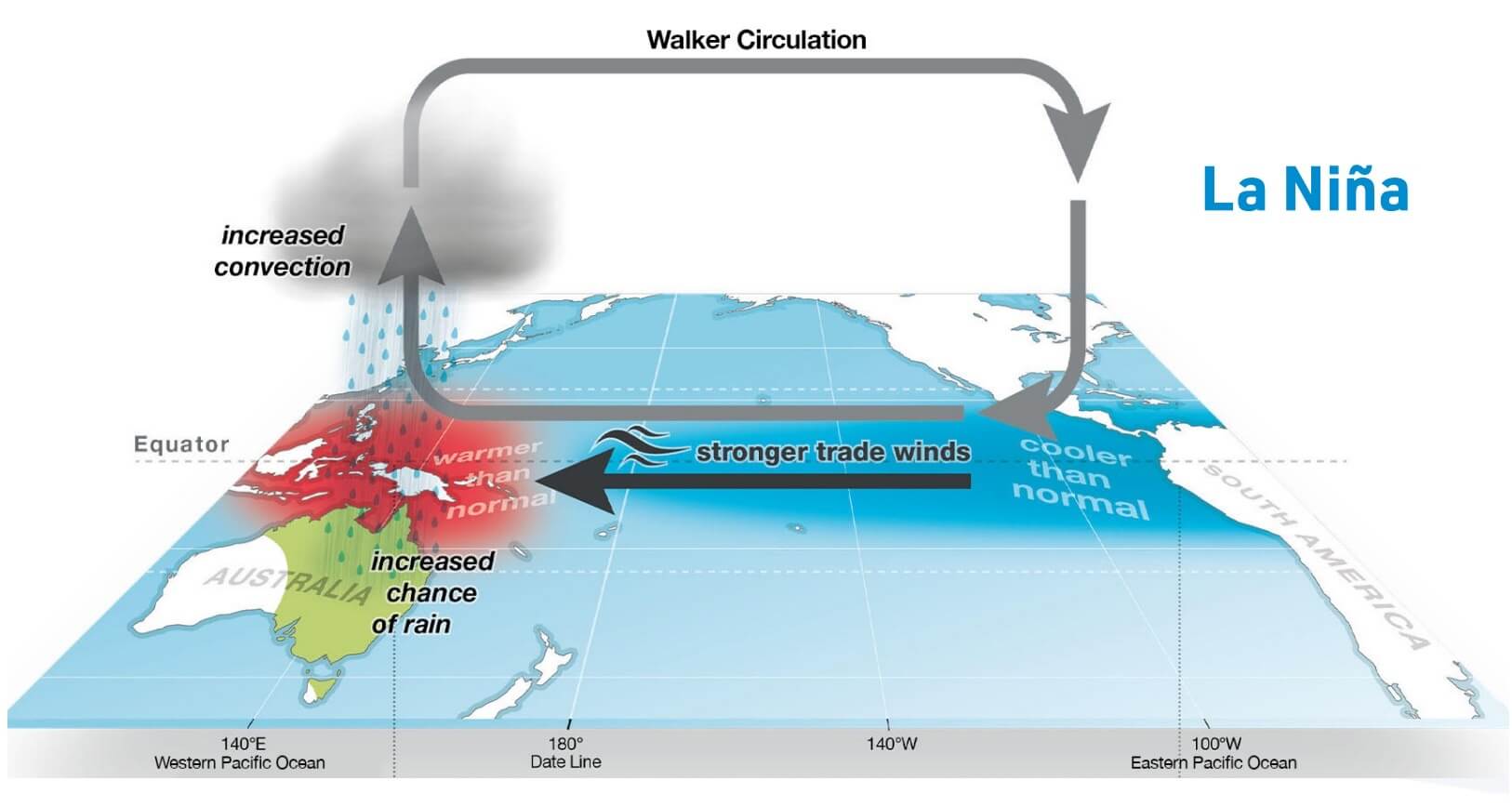
This way, ENSO significantly impacts tropical convection patterns and the ocean-atmosphere system. Through this delicate feedback system, it distributes its weather influence globally.
To better understand the ENSO development, we produced a video showing the ocean temperature anomalies from Summer to Fall 2022.
ENSO cooling restarted in August as the cold waves developed across the equatorial Pacific. But it intensified further in September as the easterly trade winds got stronger.
Historically, a strong blocking high-pressure system in the North Pacific is the most typical effect of a cold ENSO phase. In addition, a strong high-pressure system in the North Pacific aids in the development of a low-pressure region over Alaska and western Canada.
These effects usually translate well into the early Spring season. So we usually see the continued presence of the high-pressure system in the North Pacific even after Winter.
In the image below, you can see the average position of the jet stream during La Nina winters. Also, you can see the resulting weather patterns over the United States and Canada as the polar jet stream takes a different path.

The shifting jet stream brings colder temperatures and storms into the northern and northwestern United States. But it generally creates warmer and drier weather in the southern and eastern states.
This way, the jet stream can divide the United States into two weather poles. In the northern part of the country, colder and wetter events are more frequent, as the jet stream directions the storm systems and cold weather there.
ENSO SPRING FORECAST
The analysis and ensemble forecast below from ECMWF shows the forecast for the eastern ENSO region. The La Nina conditions (below -0.5) will quickly weaken as Winter ends. But the atmospheric effects can persist for some time, even as the ocean anomalies slowly fade away.
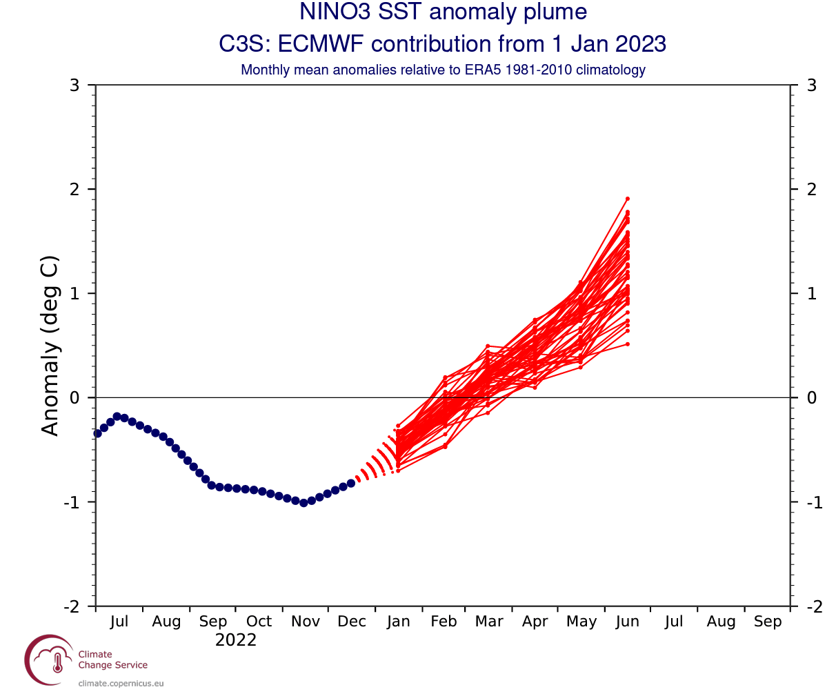
Looking at the ocean anomaly forecast map, we can see the ECMWF forecasting warm anomalies emerging across the equatorial Pacific. This indicates a likely warm phase starting to develop, also known as the El Nino.

The forecast map above does not show proper El Nino conditions but shows the emerging warm ocean anomalies. A proper El Nino will likely emerge during Summer or early Fall and impact the next Winter season 2023/2024, based on the latest forecasts.
But what weather development do the latest long-range forecasts show for Spring?
SPRING 2023 – SEASONAL FORECAST
We focused on the two main (or most used) seasonal models for this forecast: the ECMWF from Europe and the CFSv2 from the United States. Graphics are from ECMWF and the CPC/NCEP.
All these forecasts show an average picture over three meteorological Spring months (March-April-May) and show the prevailing weather patterns.
Even if the models were completely accurate, it does not mean that such weather conditions would last for three months straight. Instead, it only suggests how the prevailing weather patterns might look over the season.
ECMWF SPRING SEASON FORECAST
The pressure pattern forecast from ECMWF below shows the typical La Nina high-pressure system in the North Pacific. The low-pressure system is indicated over western Canada, with another high-pressure area over Greenland. The previous segment shows that the jet stream is bending between the high and low-pressure systems.

We also see the North Atlantic in a west-negative North Atlantic Oscillation (NAO) mode and blocking over the North Atlantic. The model hints at a possible low-pressure area over southwestern Europe in such a setup.
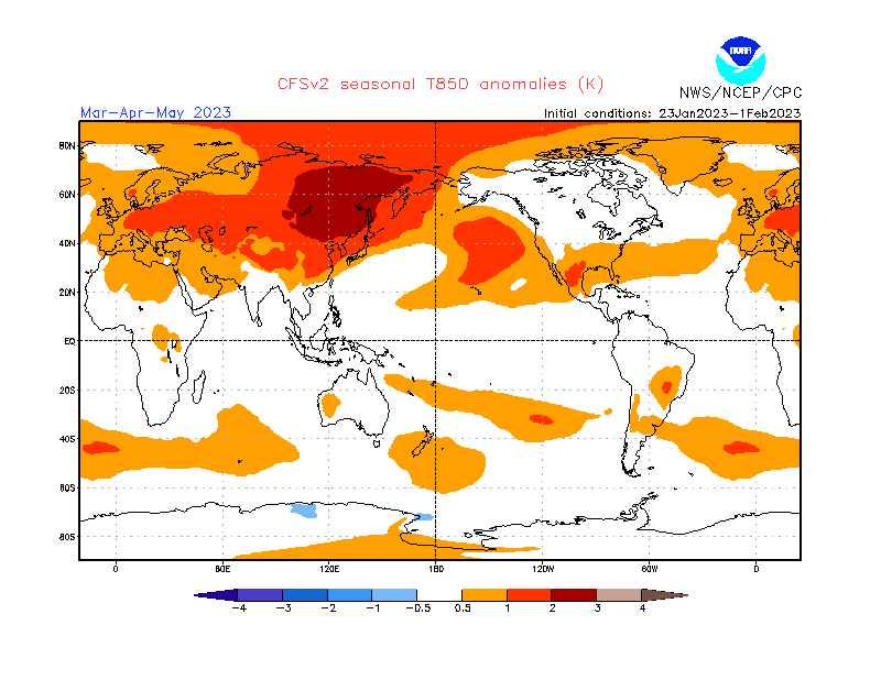
The global airmass temperature forecast below shows North America divided into two parts. First, Western Canada is forecast to be colder than normal. Thanks to the jet stream, there is a high chance of the colder air extending south, into the parts of the northern United States, over the Midwest, and partially into the northeastern United States.
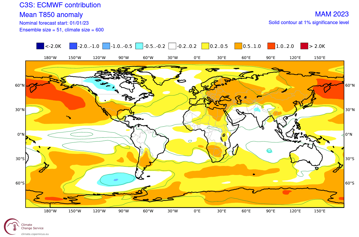
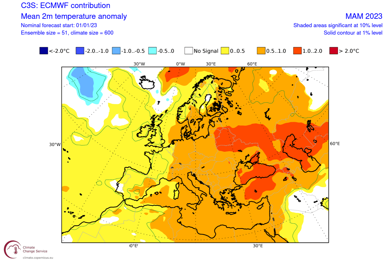
Europe also features above-normal temperatures toward the east. But we do not see strongly positive anomalies over the west due to the high-pressure system over Greenland.
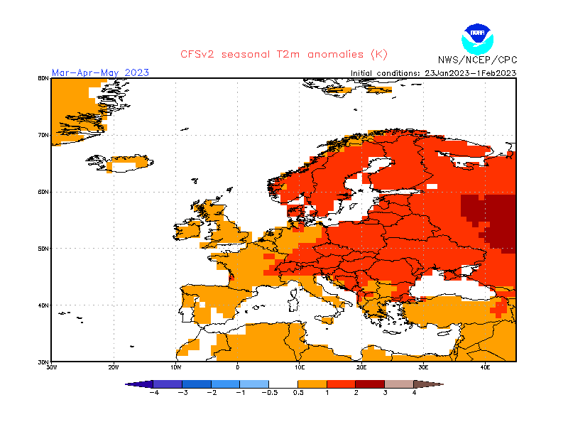
Looking closer at Europe, you can see that the surface temperatures are mostly above normal. As a result, warmer temperature anomalies and milder conditions are more likely in the eastern parts. Central and western regions likely see occasional cold fronts from the north/northwest as the Greenland high permits a more northerly flow.
Over Noth America, the ECMWF forecast hints at normal to colder-than-normal surface temperatures over the northwestern United States and upper Midwest. In addition, we see an indication of colder-than-normal air also intruding into the northeast.
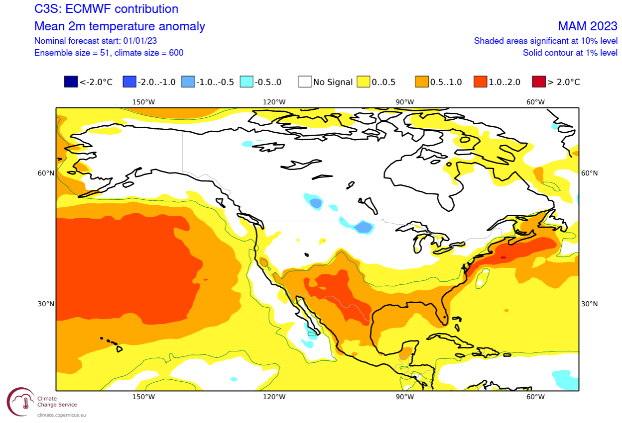
Despite being shown warmer than normal, the central parts of the United States tend to get occasional colder weather and snow in early Spring during these jet stream patterns. But mostly warmer than normal temperatures are forecast over the far south and the southwestern United States.
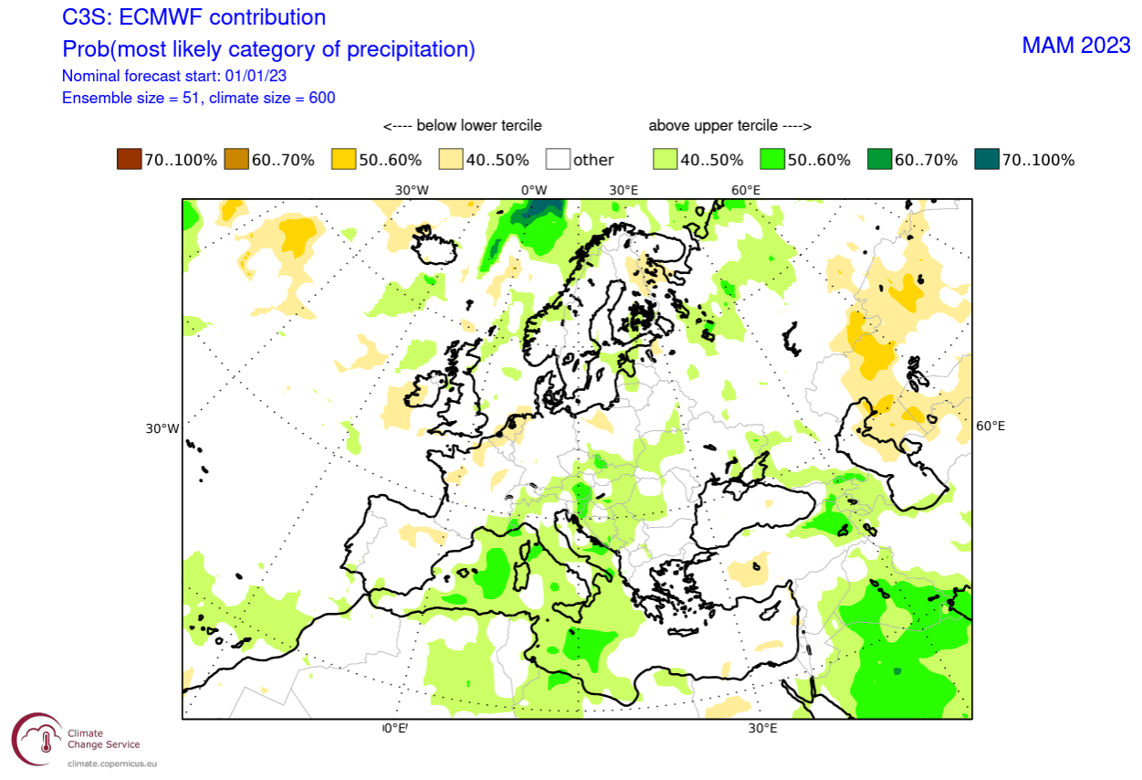
Precipitation-wise, Europe is trending to have more precipitation over the central and south-central regions. This likely indicates the model is going for a lower-pressure area over western and southwestern Europe. More precipitation is also indicated over the far northern areas.
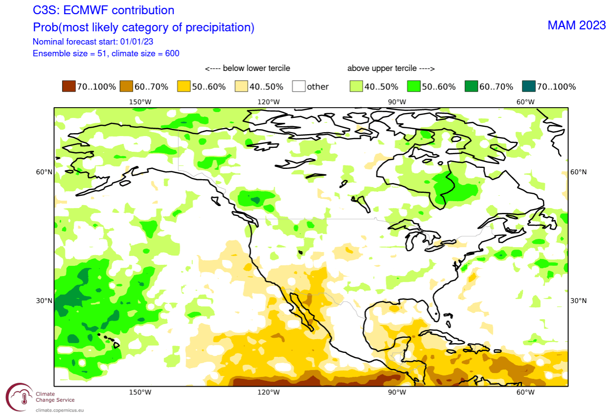
The North American precipitation anomaly forecast below shows a more normal La Nina-type pattern over Canada and the United States. As a result, the United States has wetter conditions in the northwest and the east and drier conditions in the southwest.
In combination with colder temperatures, that also affects the snowfall potential in early Spring.
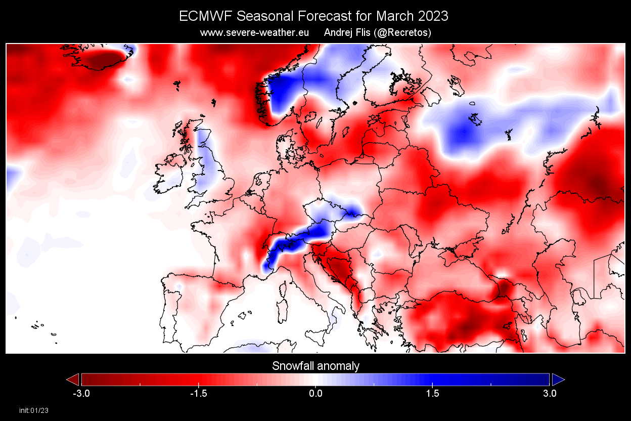
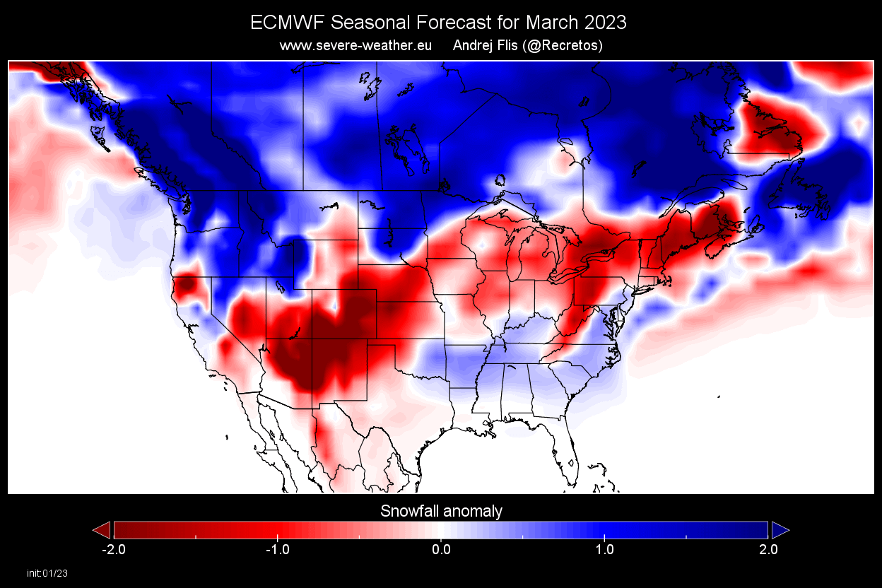
EARLY SPRING SNOWFALL FORECAST
While Spring is generally known as the start of the warmer part of the year, it still provides snowfall events, especially in early March. But looking at the March snow forecast image below, you can see most of Europe having a lower-than-normal snow amount in early Spring, except for the Alpine regions.
For early Spring over North America, you can see more snowfall than normal, covering a large area from western Canada down into the northwestern United States and the far upper Midwest. Surprisingly, the forecast also shows an increased snowfall potential over the southeastern United States.
We will produce an article with a more detailed breakdown of the snowfall potential in the Spring Season.
CFS SPRING SEASON FORECAST
In contrast to the European model, we tend to use the main North American long-range model, the CFS version 2 from the NOAA/NCEP in the United States.
The CFS model agrees with the ECMWF Over the North Pacific, forecasting a high-pressure system. No low-pressure anomalies are drawn, but in such a pattern, we know that one can be expected over Canada.

But it differs over the North Atlantic, having an indication of a low-pressure system over the region. That creates a different weather pattern in Europe, which is forecast to be under a broad high-pressure area.
Airmass temperatures over North America show no real cold anomalies, but in the case of this model forecast, that area would be over Canada and the northern United States. As expected, Europe is seen warmer than normal, with high pressure over the mainland.
Looking closer at Europe, the surface temperatures are warmer than normal over much of the continent, especially in northern and central regions. This is not too far from the ECMWF but does not allow as many persistent cold periods in Spring.
The North American forecast below shows a more La Nina-like temperature pattern. However, colder temperatures remain over western Canada and extend into the northwestern United States and the Midwest. No cold anomaly indications exist, but that is likely due to model bias and climatology. In reality, there are always areas of warmer and colder weather relative to the norm.
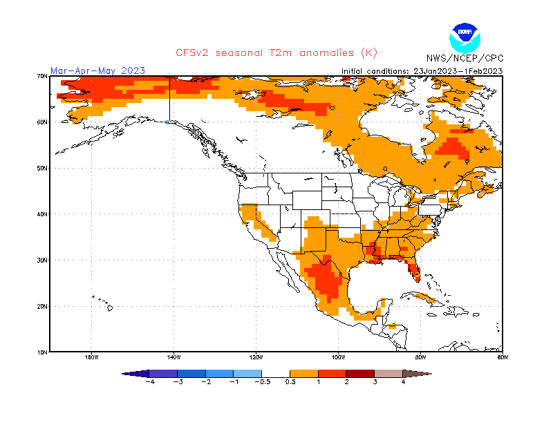
Warmer than normal weather prevails over the southern parts of the United States. A gap in the warm anomaly indicates a likely path of Spring cold over the Midwest into the northeastern United States, similar to the ECMWF.
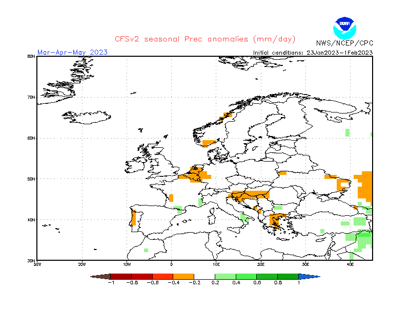
Looking at the precipitation forecast, we see mostly normal to drier conditions over Europe. That is mostly expected, given the high-pressure forecast from this model.
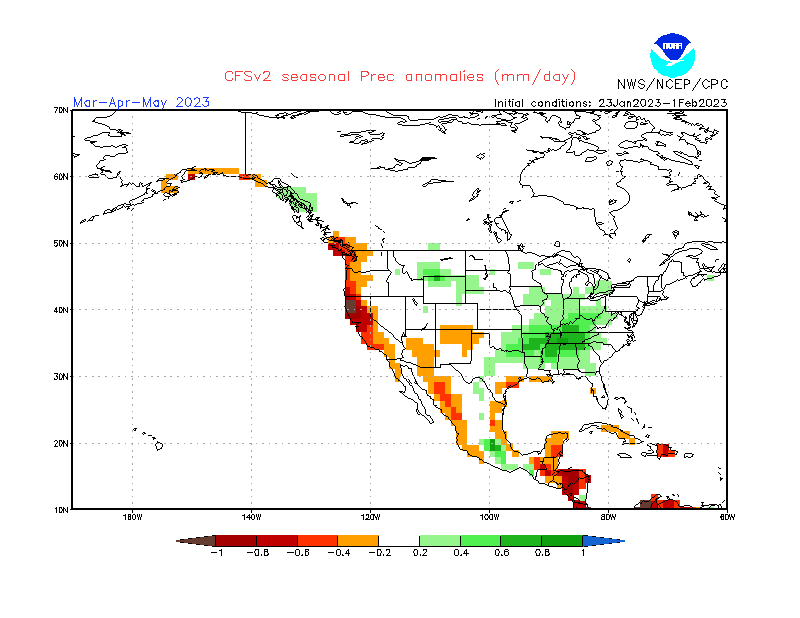
Over North America, the precipitation forecast shows drier-than-normal conditions over the southwestern United States and along the west coast. Northern and eastern United States are likely to have more precipitation than normal due to the waning La Nina influence.
SPRING OUTLOOK – SUMMARY
As reading images and descriptions can be confusing sometimes, we have put together the general Spring 2023 forecast summary:
Europe is expected to have mostly warmer than average temperatures over much of the continent. This, however, does not mean that there will be no cold fronts and colder days. ECMWF, for example, shows a blocked Greenland pattern. That increases the chances of a northerly flow into mainland Europe.
The models are not in agreement with the pattern over the North Atlantic. The main difference is the pressure anomaly over Iceland/Greenland. The ECMWF goes for Greenland blocking, while the CFS is closer to a low-pressure anomaly.
Based on the model of choice, the precipitation forecast shows mostly normal conditions. But a lot depends on the North Atlantic pattern and the possibility of a more local low-pressure area over southwestern Europe.
The North America Spring forecast looks solid to be a typical La Nina winter pattern extension. Most of western and Central Canada is to expect colder and snowier conditions, along with parts of the northern United States.
The northwestern United States is expected to have normal-to-colder Spring weather with more precipitation. This increases the chance of Spring snowfall events over the northwest. More snowfall in early Spring is also forecast over the upper Midwest.
The Southern United States has a high chance for warmer and mostly drier than normal Spring weather. This, however, does not imply that no cold front can reach the southern states. Instead, it implies that it is much less likely to get frequent cold fronts down to the very south in a La Nina pattern.
The main channel of spring cold air outbreaks seems to be from the northwestern United States and the Midwest down into the central and eastern United States. Despite the warmer temperature forecast for the central and eastern United States, a cold air outbreak can be masked into the otherwise warmer seasonal average.
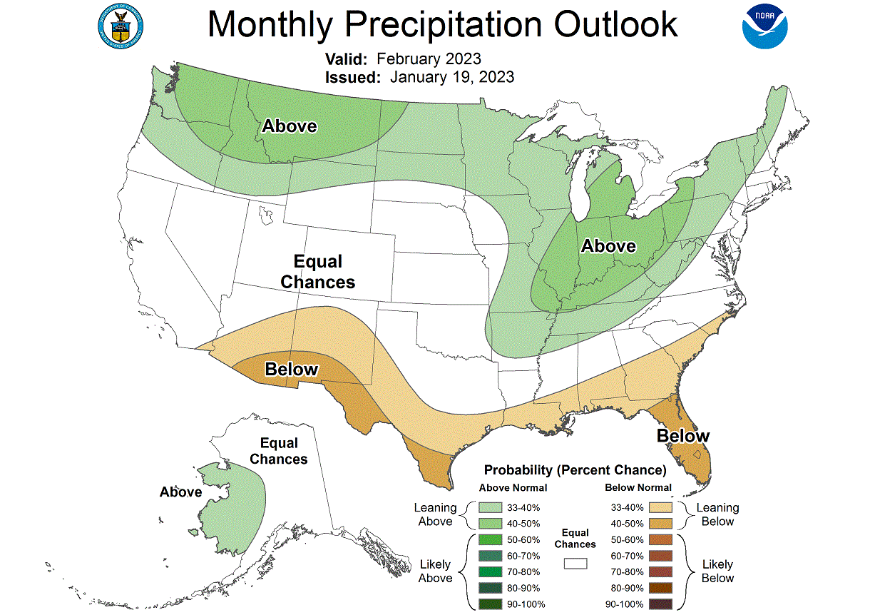
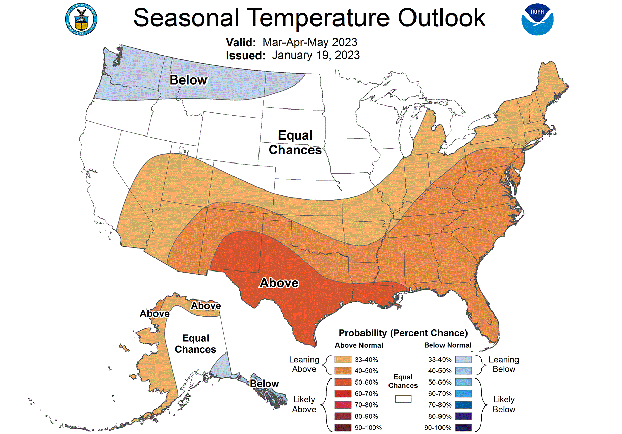
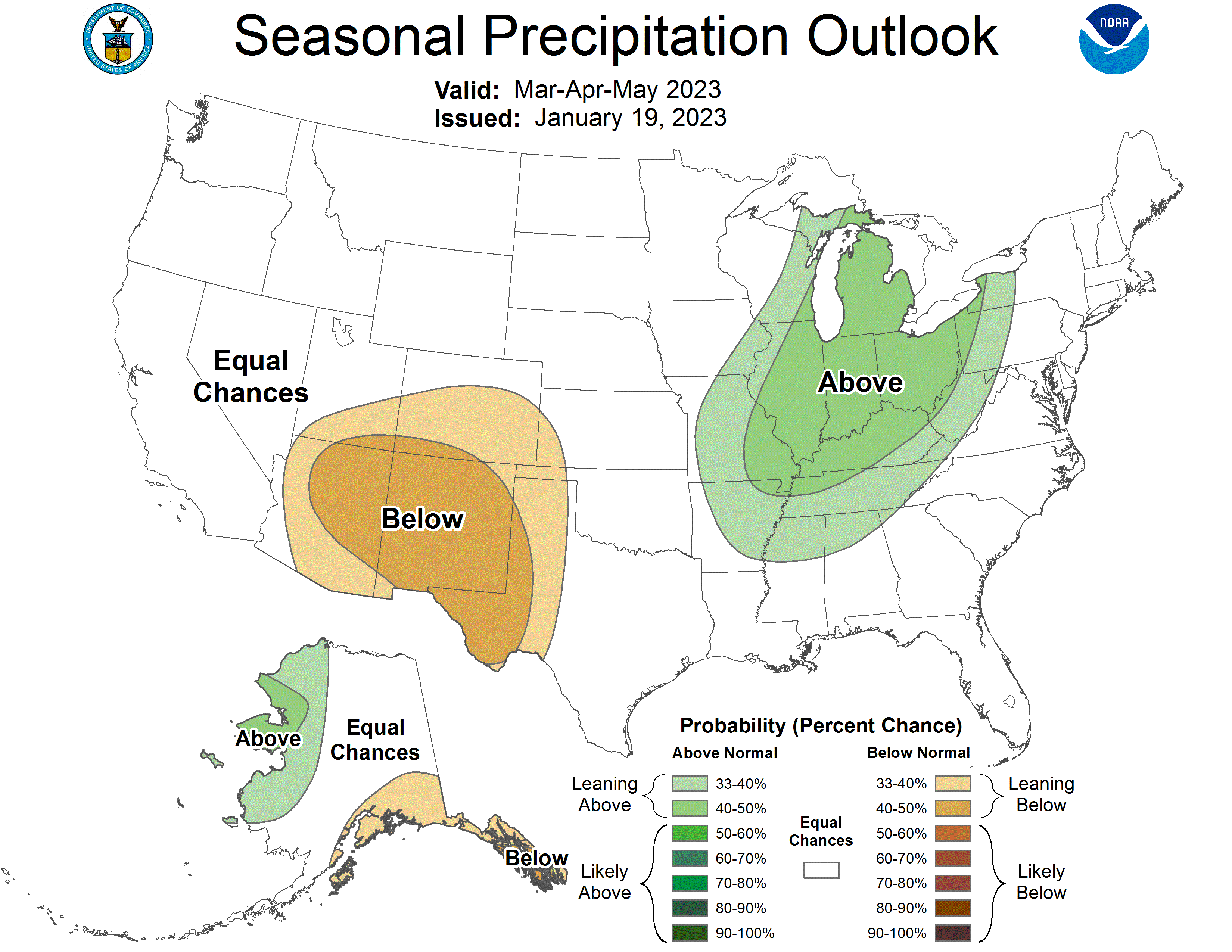
NOAA OFFICIAL SPRING OUTLOOK
Below is the official Spring temperature forecast for the United States by NOAA. It shows the temperature probability, with colder to equal chances in the northern United States. The southern half of the country and the northeast have a higher probability of warmer than normal weather, as seen in the models above.
The official precipitation forecast is also quite similar to the model forecast. We see an equal-to-higher probability for more precipitation in the eastern United States across the Ohio Valley. On the other hand, the southwestern United States is forecast to have a drier-than-normal spring season.
But there is one event that can significantly impact the Spring weather patterns.
STRATOSPHERIC POLAR VORTEX COLLAPSE
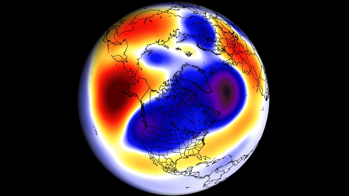
Below is the pressure and temperature forecast for the middle Stratosphere around mid-February. You can see a strong stratospheric warming wave advancing across the Polar regions. The Polar Vortex is pushed out of the North Pole and is strongly weakened, with a reversed circulation.
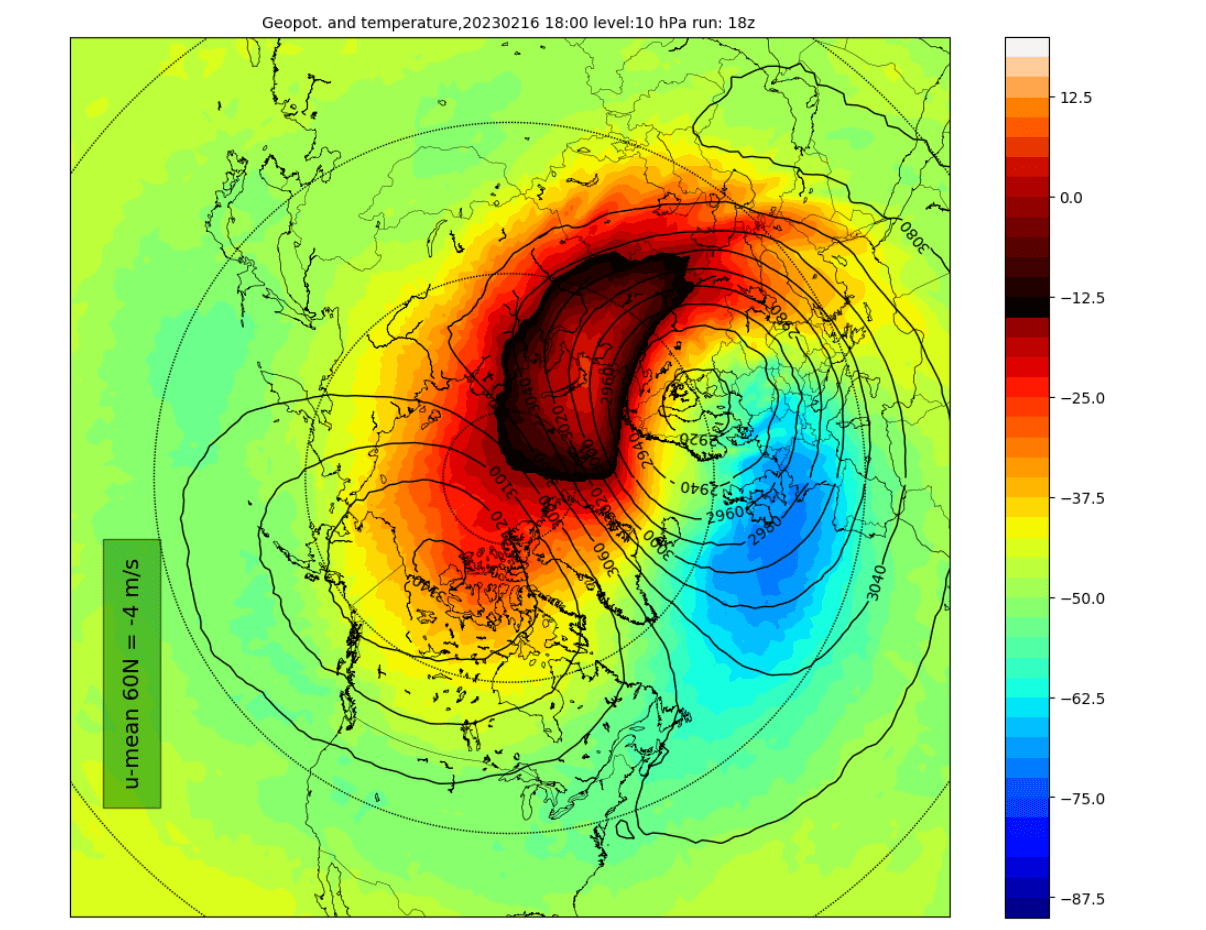
This means that the stratospheric circulation is breaking down, changing the influence of the Stratosphere downward on the lower levels.
Looking at the vertical pressure anomalies below, you can see the marked forecast for the first half of February. Again, it shows high-pressure anomalies in the Stratosphere, associated with strong warming anomalies.
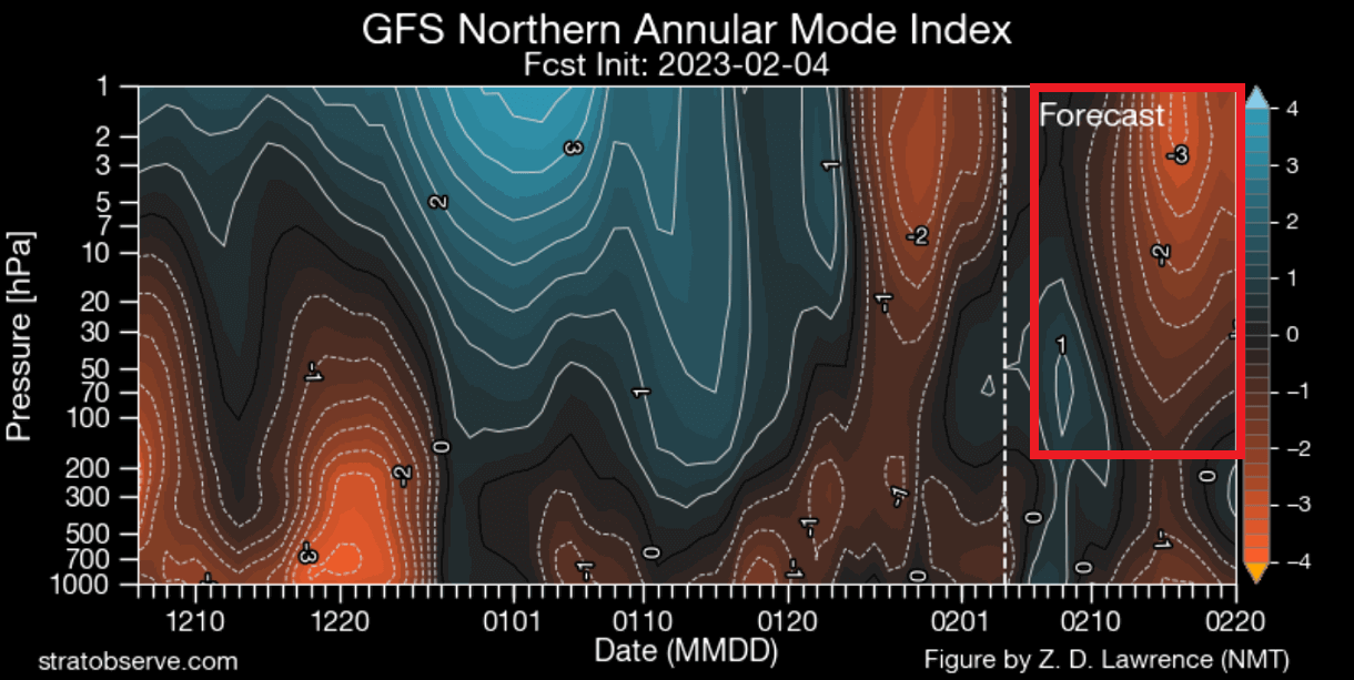
It is unknown how this will pan out exactly and how strong the stratospheric warming will be. But based on the first indications, we are likely dealing with a proper breakdown of the stratospheric circulation that can influence the weather in the early part of Spring.
We will keep you updated on the developing weather trends in the coming seasons, so bookmark our page. Also, if you have seen this article in the Google App (Discover) feed, click the like button (♥) there to see more of our forecasts and our latest articles on weather and nature in general.
Don’t miss: