The Polar Vortex is starting to weaken as a strong Stratospheric Warming event is about to unfold. As the forecast indicates, the Polar Vortex will be heavily deformed but will not fully collapse. These important events can have a significant impact on the rest of Winter in the United States, Canada, and Europe.
Weather and the stratospheric Polar Vortex are strongly connected, especially in Winter. So it matters greatly in what shape or form the Polar Vortex is as we go through the cold weather season.
We will look at the important role of the Polar Vortex during the Winter season and how it can shape our weather when it is strong or weak. But more importantly, we will look closely at the latest forecasts and how the Polar Vortex disruption events might be a major player for the rest of Winter.
POLAR CIRCULATION IN THE ATMOSPHERE
As we head into autumn, the polar regions start to cool. This is because the Sun gets lower, and less energy reaches the North Pole. But as the polar temperatures drop, the atmosphere further to the south is still relatively warm.
This causes a strong temperature difference between the polar and sub-tropical regions, and a large low-pressure (cyclonic) circulation starts to develop across the Northern Hemisphere. It extends from the surface layers high up into the atmosphere. This is known as the Polar Vortex.
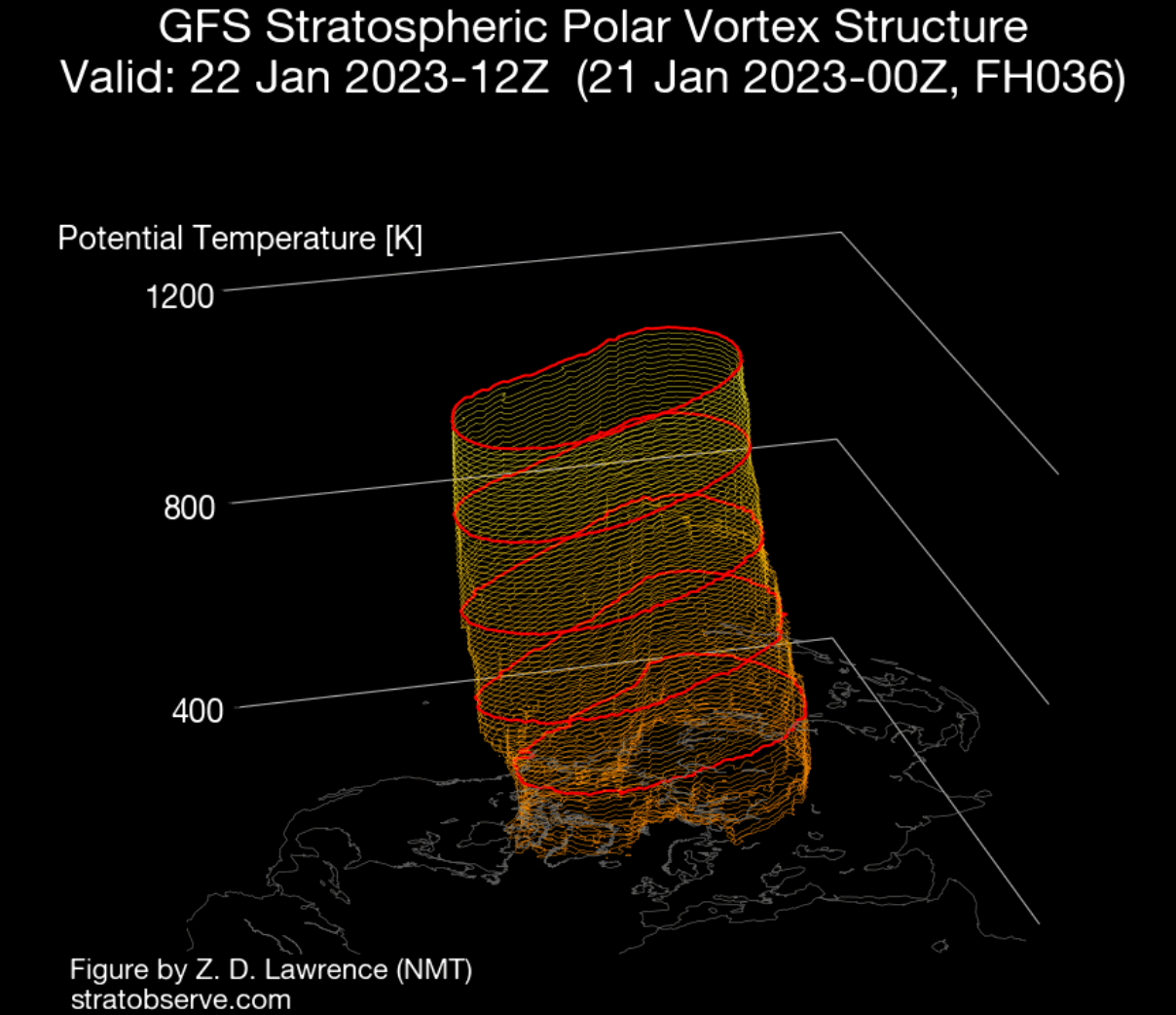
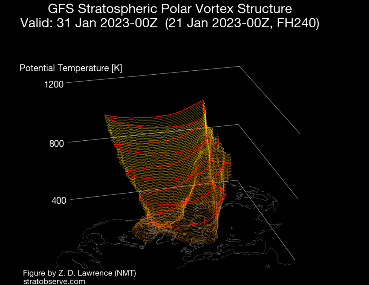
We produced a 3-dimensional image of the Polar Vortex. The vertical axis is greatly enhanced for better visual presentation. You can see the actual structure of the Polar Vortex, connecting down to the lower levels to the pressure systems.
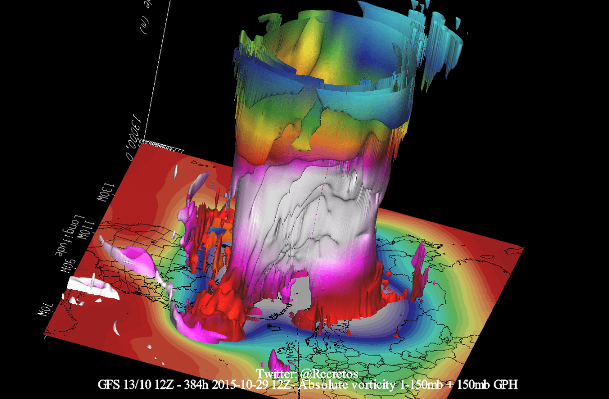
The Polar Vortex extends high up into the atmosphere. You can see the atmospheric layers in the image below. The lowest level of the atmosphere is called the troposphere, where all the weather events are. But above that, we have the Stratosphere, a deeper and drier layer and the home of the ozone layer.
For this reason, we tend to separate the entire Polar Vortex into an upper (stratospheric) and a lower (tropospheric) part. They both play their role differently, which is why we monitor them separately. But it is also very important if they are properly connected—image by NOAA-Climate.

The upper (stratospheric) part is more circular and symmetrical as it spins higher above the ground. But the lower structure of the Polar Vortex is much more uneven and mainly disrupted. That is due to the influence of the terrain/mountains and strong pressure systems acting as obstacles in the flow.
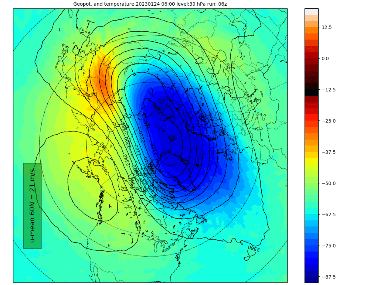
The image below shows the high-altitude Polar Vortex at around 30km/18.5miles in the middle Stratosphere during Winter. It is circular, with the temperature dropping quickly towards its cold inner core.
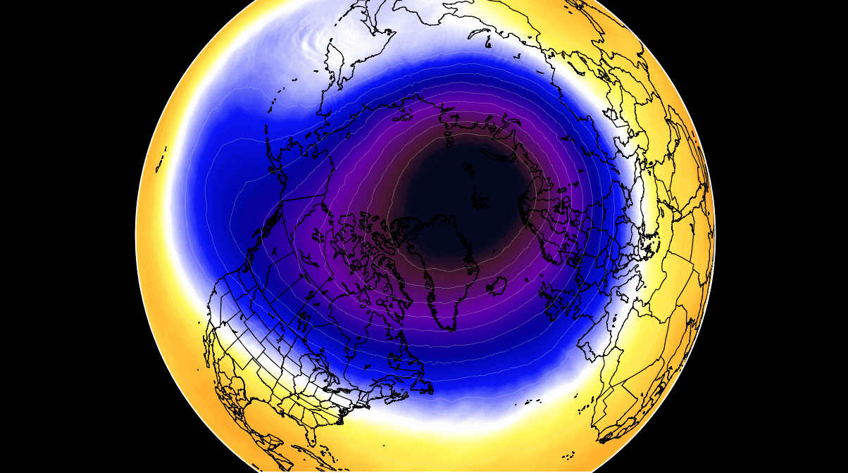
The stronger winds are typically found in the outer edge, also called “the surf zone”. Winds are of great importance when describing the Polar Vortex, as they are usually the first to show that something in the Polar Vortex is changing.
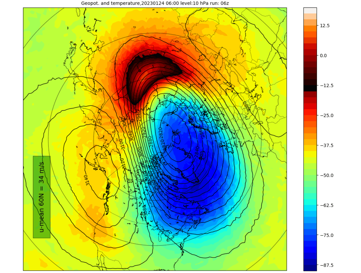
In the following image below, we have the lower layers of the Polar Vortex at around 5km/3miles. The closer to the ground we go, the more deformed the Polar Vortex gets. That is because it has to interact with the terrain and strong pressure systems around the Hemisphere.
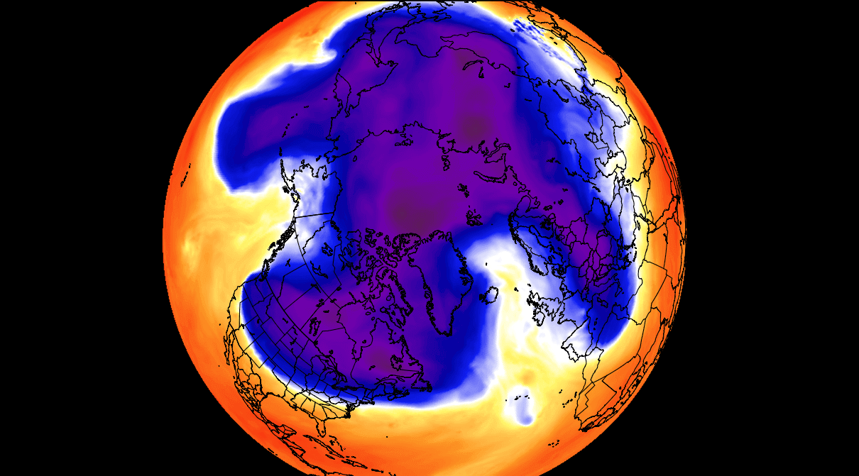
Notice the cold “arms” extending colder air and snowfall into the lower latitudes. These arms pack a lot of energy and can create strong winter storms, like the latest artic outbreak across the United States.
So to recap, the Polar Vortex behaves like a very large cyclone, covering the whole north pole down to the mid-latitudes. It is connected through all atmospheric levels, from the ground up, but can have different shapes at different altitudes.
We monitor any Polar Vortex activity because it can have weather implications across the entire Northern Hemisphere. And that is regardless if it is weak or strong.
A strong Polar Vortex usually means strong polar circulation. This locks the colder air into the Arctic circle, creating milder conditions for most of the United States and Europe.
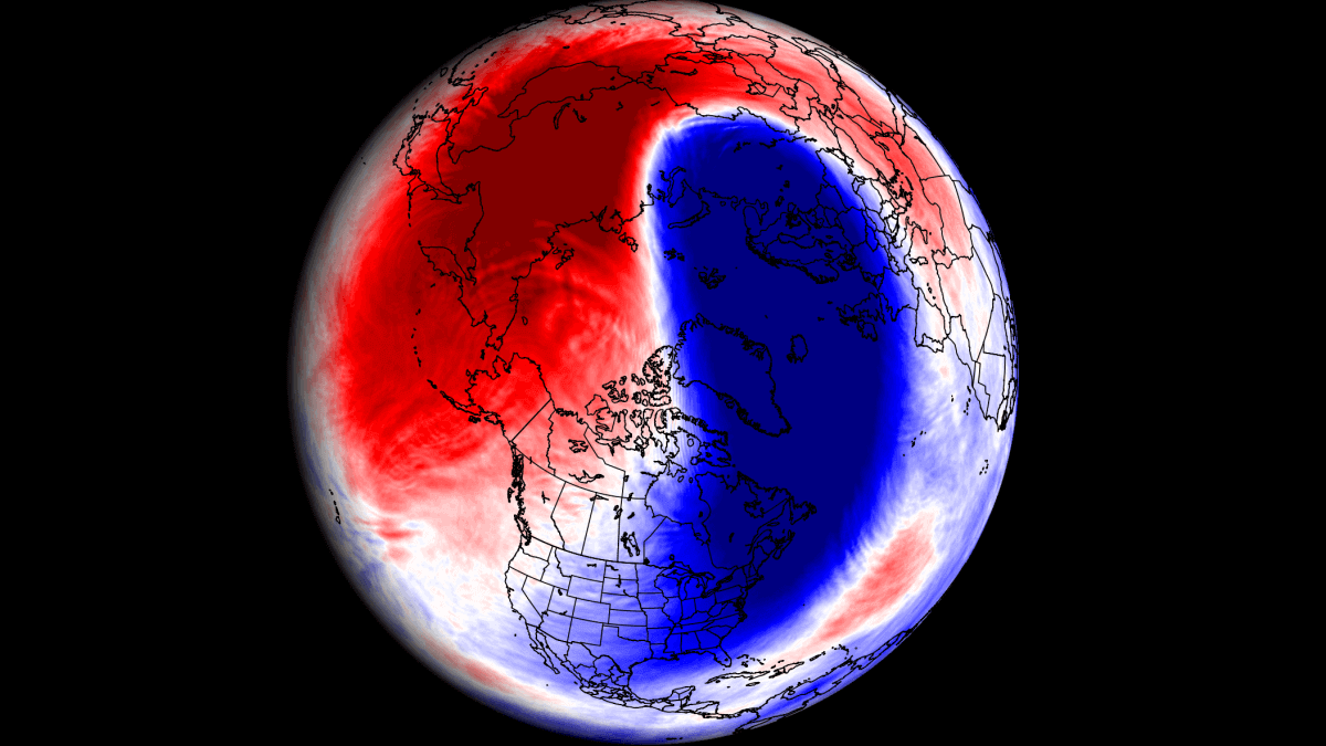
In contrast, a weak Polar Vortex creates a weak jet stream pattern. As a result, it has a harder time containing the cold air, which can now escape from the polar regions into the United States and Europe. Image by NOAA.

To put the Polar Vortex into perspective, we produced a high-resolution video below, showing the Vortex spinning over the Northern Hemisphere in the Stratosphere at the 30mb level, around 23km/14miles altitude.
The video mainly shows that the Polar Vortex is not just one winter storm or a cold outbreak that moves from the Midwest into the northeastern United States.
It is a large cyclonic area spinning over the entire Northern Hemisphere, from the ground up to the top of the Stratosphere and beyond, reaching over 50km/31miles in altitude.
So, what is currently going on with the Polar Vortex?
IT SPINS IN THE STRATOSPHERE
The Polar Vortex is elongated, being compressed between two high-pressure areas. You can see it in the forecast image below, which shows the mid-stratosphere level (30km/18.5miles). A high-pressure zone is over the North Pacific and the western Arctic ocean. The Polar Vortex still has a broader cold core, but a warming area is forecast to appear early this week in the Stratosphere over Siberia.
Lower down, at around 23km/14miles altitude, is the 30mb pressure level. Even here, we can see the elongation of the Polar Vortex, with a warming area appearing in two days. The lower we go, we weaker the warming usually is, but if it goes lower, it is usually more persistent and can have a broader influence.
If we look at the 3D structure, we can fully see the elongated structure of the Polar Vortex. The elongation is present all the way, from the upper levels to the lower levels. This shows that the stratospheric high-pressure is present in the eastern and western hemispheres, pressing onto the Polar Vortex.
Another way to look at the vertical structure is by looking at the pressure anomalies in the atmosphere. The image below is by weatheriscool.com, and it might look complex but is fairly easy to read. The top of the image is the top of the Stratosphere, and the bottom is the surface level. Blue is for lower pressure, and red indicates higher pressure.
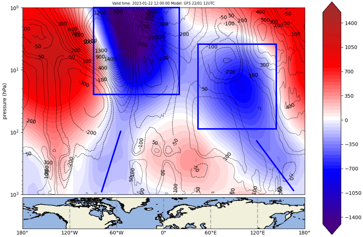
You can see the non-compact Polar Vortex in the Stratosphere due to being elongated. But you can see that it is still connecting down to the surface. More directly, it connects down into eastern Canada and western Greenland. But the other part connects down into northeastern Siberia.
Looking below is the pressure pattern forecast for the start of this week. You can see the two marked low-pressure areas. These are the same connecting points we showed in the previous image connecting to the Polar Vortex higher up in the Stratosphere.

But notice the strong high-pressure area extending from the North Atlantic over Northern Europe and further to the east. That region will be co-responsible for driving additional energy into the Stratosphere. It will fuel more disruption for the Polar Vortex.
POLAR VORTEX OUTLOOK
As mentioned, the temperatures in the Stratosphere are already rising as a warming wave is developing. You can see that in the image below by NOAA/CPC. The red line is the analysis, showing the stratospheric temperature increase since early January After hitting record-cold temperatures in the middle Stratosphere.

But the green lines (in the black box) are the forecast, showing a stronger incoming event. And as some forecasts indicate, this could raise the stratospheric temperatures to record high levels for this time of year.
If you look at the temperature anomalies in the Stratosphere below, you can see they have been colder than normal for most of the season so far. But the forecast part shows a direct opposite pattern, with strong warm anomalies now incoming.

The ECMWF ensemble forecast below shows the mid-stratosphere forecast for the last week of January. Again, you can see a strong warming event circulating around the Polar Vortex, creating a strong disruption in the Stratosphere.

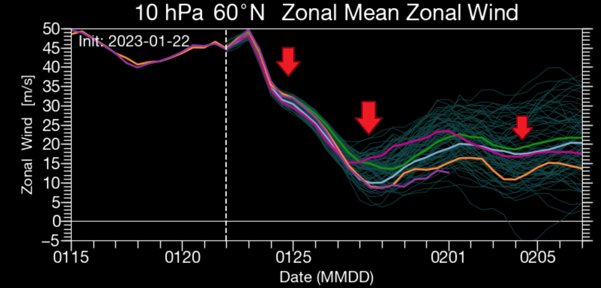
The best way to monitor the strength of the Polar Vortex is by looking at the wind speeds around it. Below is a great forecast image by Tomer Burg, showing the strength of the stratospheric “jet stream” to oversimplify it.
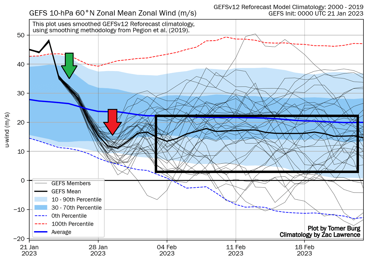
The green arrow shows the first weakening of the Polar Vortex, starting this week. But soon after, we have a much stronger weakening, coming from the strong warming event, as shown by the ECMWF ensemble forecast above.
So we will now look at this larger stratospheric disruption event and how it will develop into February.
POLAR VORTEX MAJOR DISRUPTION
But where do these warming waves suddenly come from? Usually, it is from the direct influence of strong pressure systems, having an impact upwards into the Stratosphere. Pairs of pressure systems are also known as Rossby Waves.
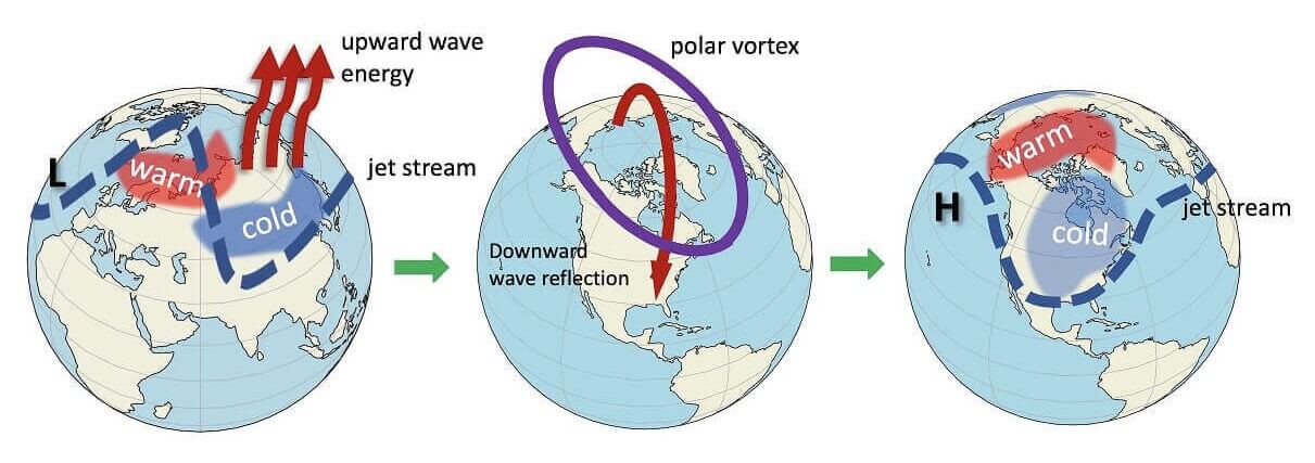
Rossby Waves (a pair of strong high and low-pressure systems) deflect energy upwards into the Stratosphere. That energy can deform the Polar Vortex, temporarily pausing its strengthening or weakening its circulation.
In the image below, you can see the vertical wave activity example. First, the energy goes into the Stratosphere, which impacts the Polar Vortex, and later affects the polar circulation back down, changing the weather patterns.
We can see the Rossby waves in the pressure forecast below. Notice the pairings of high and low-pressure regions. This setup enables the “wave breaking,” sending energy upwards into the Stratosphere and disrupting the Polar Vortex dynamics.

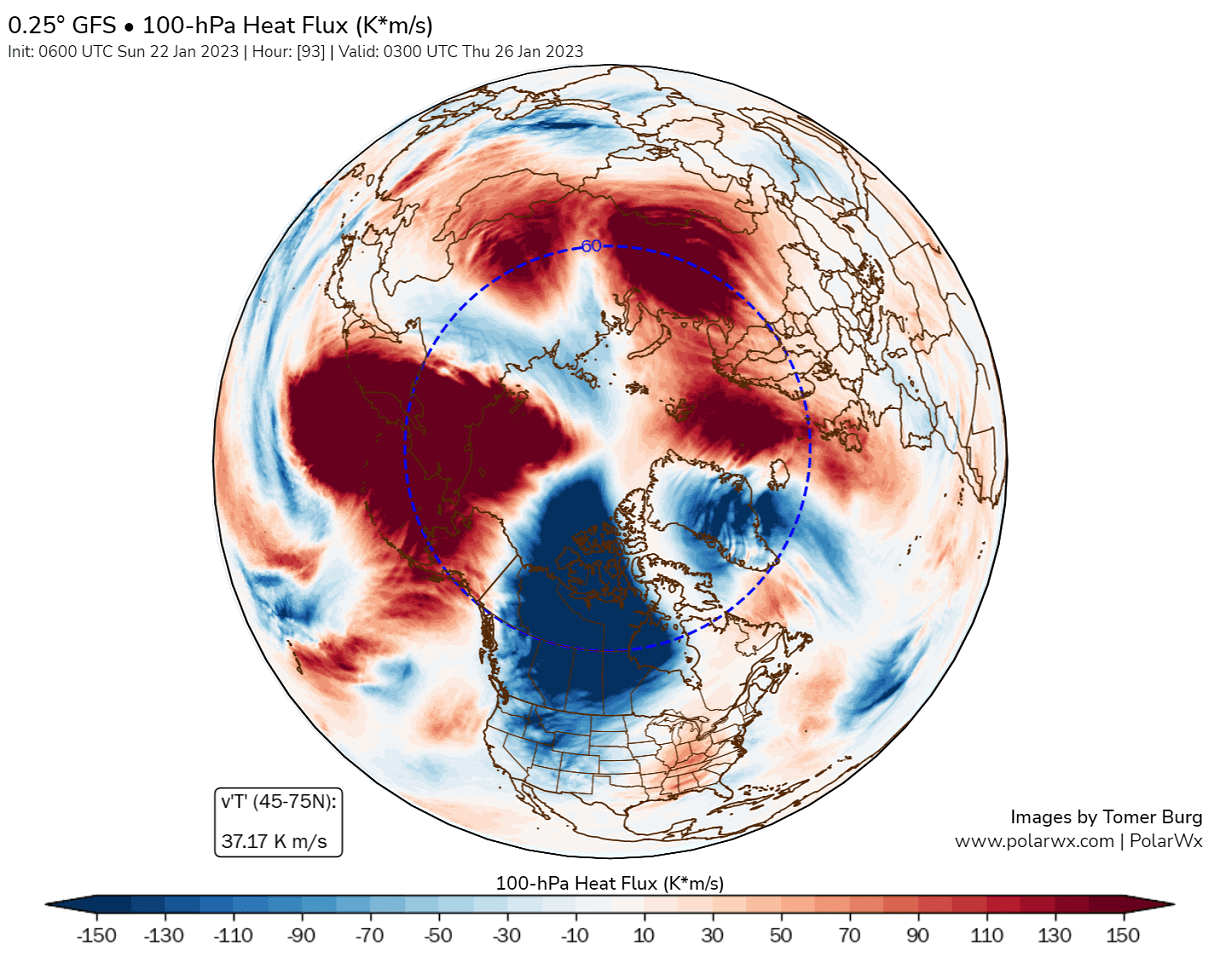
For that purpose, we have a special type of graphic. Below you can see the 100mb heat flux chart. It shows the temperature transport from the troposphere to the Stratosphere. Again, you can see some strong regions with positive upward heat/energy transfer.
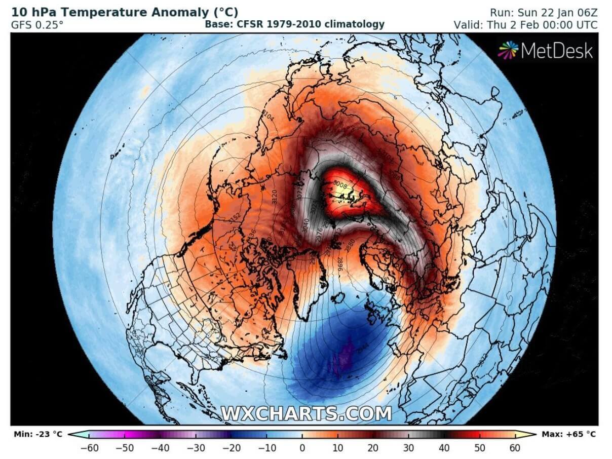
Looking at the Stratosphere, you can see in the forecast below where that manifests in the middle levels. A very strong area of warming is forecast to appear over Siberia. Temperatures are forecast to reach above-freezing levels, peaking around 20°C (68°F). That is abnormally high for the Stratosphere this time of the year.

We can look at the anomaly forecast for that level to see just how abnormal it is. The peak anomaly is 65°C above normal (117°F). That is a significant warming wave if it manifests around these levels.
The pressure anomaly also shows the strong stratospheric high-pressure system pushing into the Vortex. It causes a strong displacement of the Vortex. Together with the strong temperature wave, it creates a significant disruption of the stratospheric circulation.

You can see that even better in the 3D vertical profile. The Polar Vortex is strongly compressed and stretched. So you can nicely see how the stratospheric high-pressure area pushes into the Vortex.
But what follows after this? And will this be enough to create a major disruption of the surface weather patterns?
WEATHER ABOVE AND BELOW
ECMWF shows warm anomalies taking over the stratospheric polar regions in the first days of February. Despite the Polar Vortex still being present and offset, it is severely weakened.

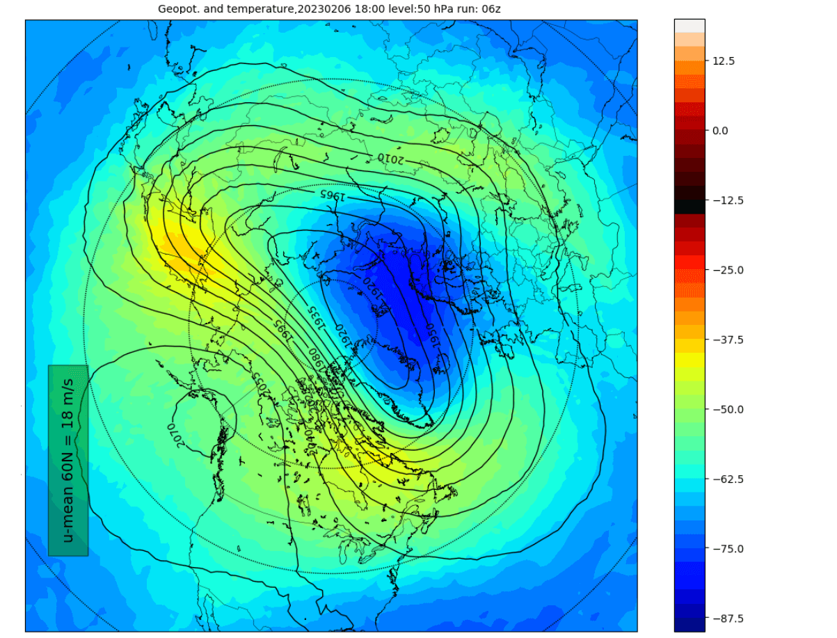
The forecast below for early February shows the Polar Vortex offset towards the east and reduced in size. You can see residual warming still wrapping around the Polar Vortex. But despite being a miniature version, the Vortex is not gone and maintains good circulation around its core.

You can see that even better if we look at the vertical 3D structure. We have a smaller version of the Polar Vortex on the top levels, offset from the Arctic circle. But going down, the structure of the Polar Vortex covers a large area, despite being deformed higher up. This shows the potential limitations of this disruption event in the Stratosphere.

Below is the temperature and pressure forecast for the lower Stratosphere (19km/12miles). You can see that the warming wave does reach further down to these altitudes. But the shape of the Polar Vortex is larger, as the pressure waves are weaker at these levels and show a smaller effect than in the higher levels. Just like you can see in the previous image.
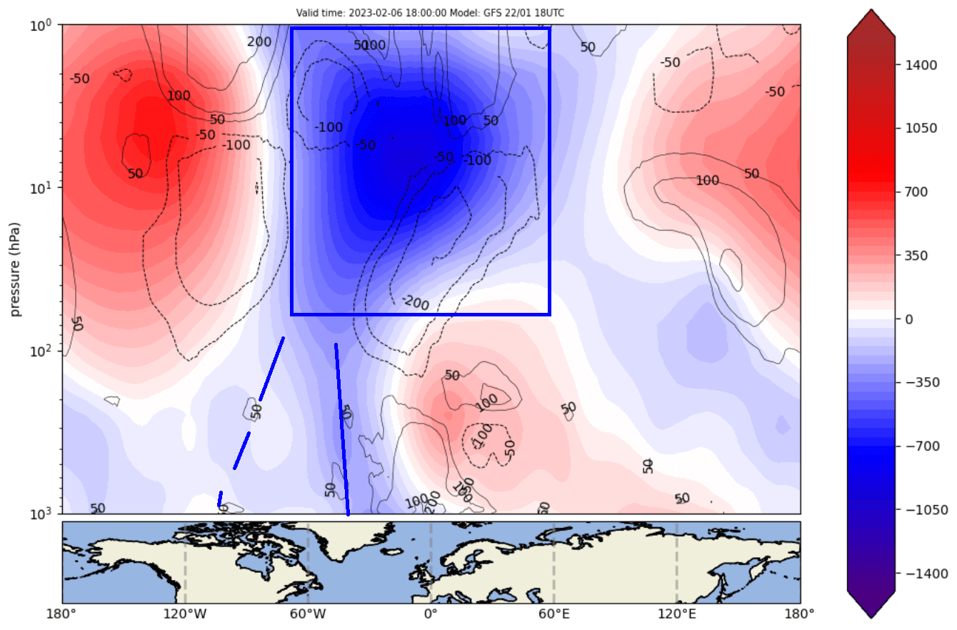
Looking at the vertical anomalies again, we can see the weakened Polar Vortex in the Stratosphere. It has lost some connection to the eastern parts of the Northern Hemisphere. But it still shows a connection downwards around the eastern Canada and Greenland regions.
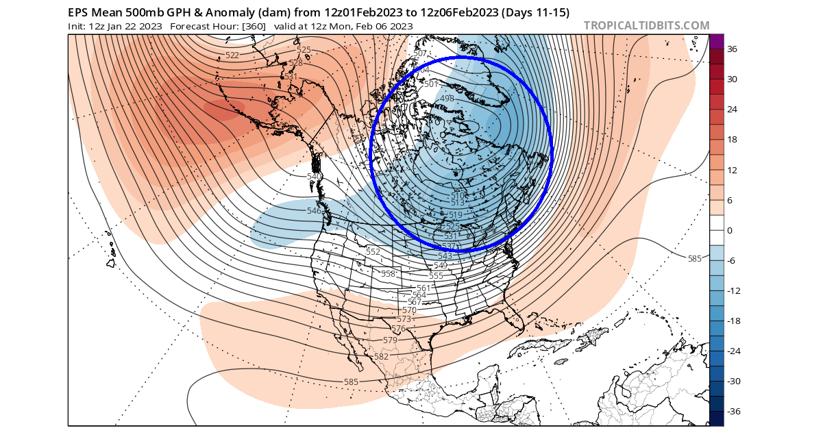
You can see this if we look at the pressure pattern in the lower levels. Notice the broad low-pressure area over Canada, the northern United States, and Greenland. This is the likely main connection to the stratospheric Polar Vortex, as far as pure anomalies go.
Looking at the temperature forecast for the same period, you can see the cold air returning to much of the United States. This is because the low-pressure area sits over the northeastern United States and eastern Canada, which enables a northerly flow down into the United States.

The NOAA official temperature outlook for the medium range shows the colder air returning to the Midwest and the northeastern United States. This covers a slightly different timeframe than the ensemble forecast above, but it is likely to adjust as it covers this whole timeframe.
Looking at the precipitation, we can see mostly above-normal precipitation. In areas with colder than normal temperatures, that can mean snowfall, especially in the northern United States. The open question is where the snowfall borderline will be, depending on how far south the cold outbreak goes.
At this point, we cannot say this is the direct effect of the stratospheric warming event. But, from what we can see, this will not be a proper Polar Vortex collapse. For that, you need to reverse the stratospheric jet stream, which is not seen at this point.
In the image below, you can see the stratospheric westerly wind speeds around the polar circle. The weakening is strong, but you can see that it never really reaches into negative territory, which would mean a collapse of the stratospheric circulation.
But, this is still a proper disruption event. And even without a full-on collapse, it can impact the weather below. It is still too far to talk about specific weather impacts apart from what we have shown above. But such strong changes can have a domino effect on the circulation below.
If not the weakening itself, the comeback of the Polar Vortex can be another factor that changes the weather in one way or another.
One example of a major collapse event was seen in the 2020/2021 Winter season in early January. We will look at this event below, as it was a nice example of how the weather patterns can change in a proper stratospheric Polar Vortex collapse event.
MAJOR POLAR VORTEX COLLAPSE
A proper Polar Vortex collapse event (Sudden Stratospheric Warming) basically means a strong temperature and pressure rise in the Stratosphere and a resulting collapse of the Polar Vortex circulation.
There is one major condition for a disruption event to be classified as a Sudden Stratospheric Warming event or a full collapse. The stratospheric winds, which are mostly westerly in Winter, must be reversed to easterly. This means the negative territory that we have talked about just above.
Below you can see the temperature in the mid-stratosphere in early January 2021, as the Sudden Stratospheric Warming event was in progress. The temperature wave fully spread over the North Pole, splitting the Polar Vortex and breaking its circulation.

The image below shows atmospheric pressure anomalies. Negative values indicate lower pressure (blue colors), and positive values indicate higher pressure (red colors). We have altitude from the ground up to the top of the Stratosphere (~46km/28mi) for the Winter/Spring 2021 period.
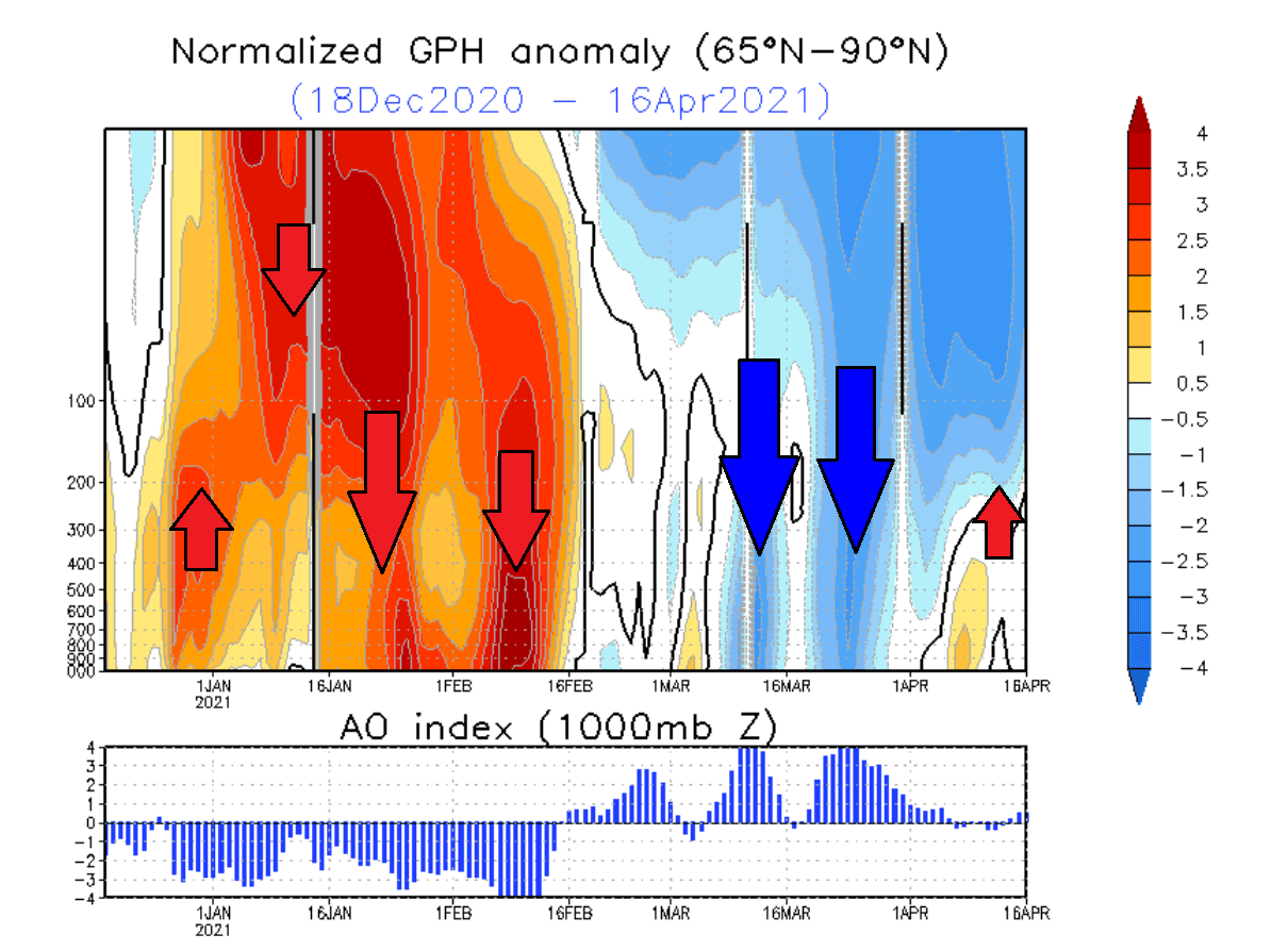
In early January, strong positive values in the Stratosphere are associated with the higher pressure buildup during the stratospheric warming event. The event and its influence slowly descended over time, reaching lower levels by mid and late January.
This persisted well into February, influencing the weather patterns even when the stratospheric warming was already over.
We produced an analysis image of this January-February winter period, showing pressure and temperature anomalies. The image below shows the pressure anomalies, where a strong high-pressure system dominates the North Pole. This dominant high-pressure system originated from the stratospheric warming event and the Polar Vortex collapse.
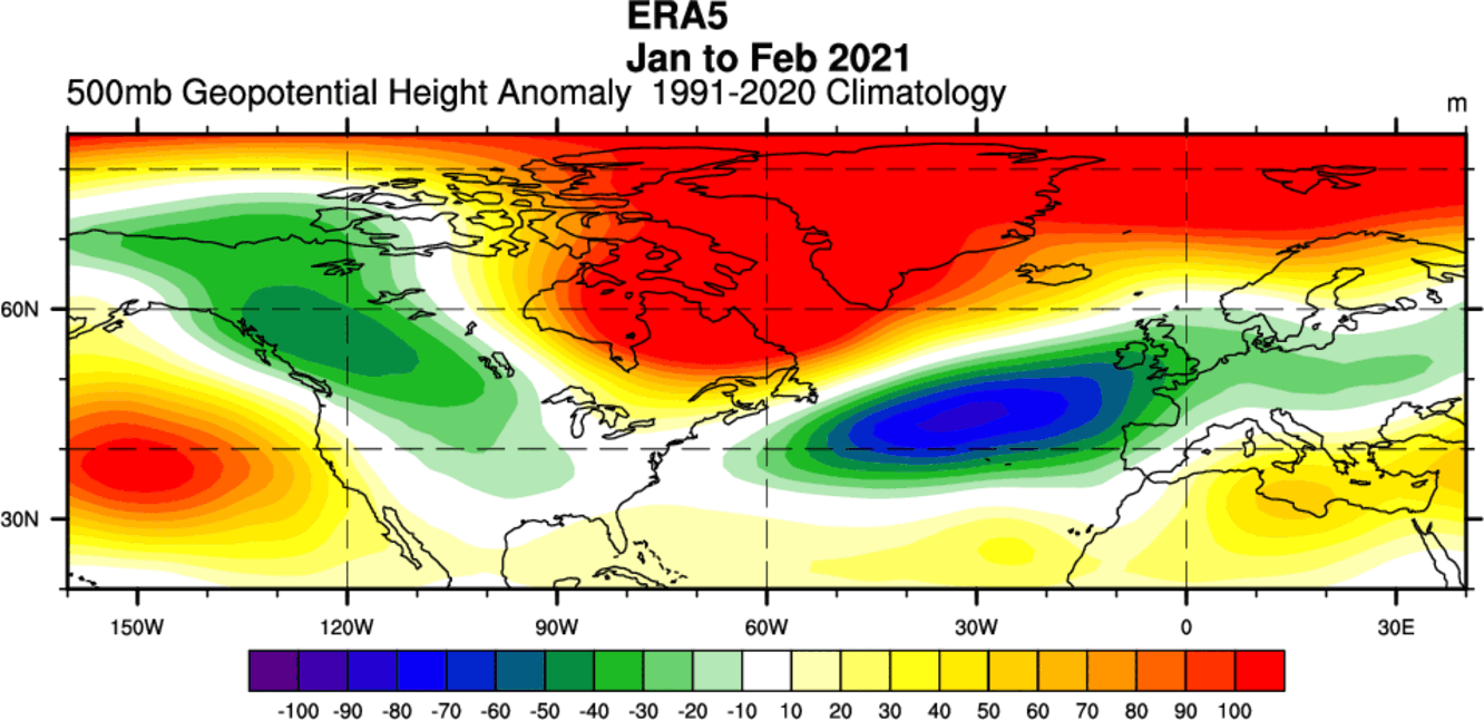
A strong high-pressure system over the Arctic can heavily disrupt the weather circulation and unlock the cold air from the Arctic regions towards the mid-latitudes.
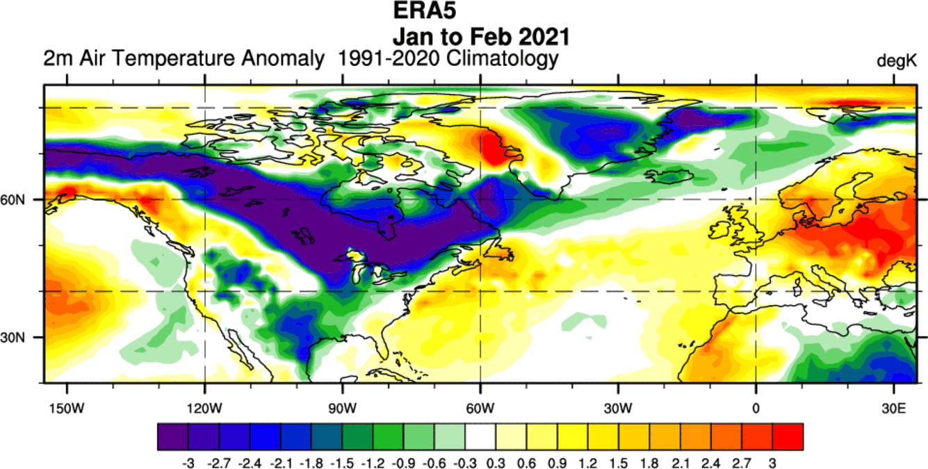
The image below shows the temperature anomalies in the same period. Warmer than normal temperatures were present under the high-pressure system over the polar regions. But the collapse of the Polar Vortex pushed cold Arctic air out into Canada and most parts of the United States, especially the Midwest.
The weather after a Polar Vortex collapse event is not always the same. A lot depends on the pre-existing weather patterns, as in some cases, the effect of stratospheric warming can be “deflected” or doesn’t mix into the lower parts very well.
You have to understand that it takes some time for the effects from the Stratosphere to reach the lower levels. That is why we usually look at the 0-30 day periods after such an event to identify the weather changes.
The average temperature of 0-30 days after a Polar Vortex collapse event shows that most of the United States is typically colder than normal, along with Europe. Note: this is an average picture of many SSW events. Each stratospheric warming event is different and does not automatically mean a strong winter pattern.

Looking at the snowfall below, we can see above-average snowfall over much of the eastern United States and Europe. Again, this is an expected response, as typically, after major stratospheric warming, the colder air has an easier path towards the south and into these regions.

So as you can see, having a strong or weak Polar Vortex can significantly change Winter weather in the United States, Canada, and Europe. For this reason, we closely monitor the weather patterns and all activity surrounding the Polar Vortex.
We will keep you updated on the global weather pattern development, so bookmark our page. Also, if you have seen this article in the Google App (Discover) feed, click the like button (♥) there to see more of our forecasts and our latest articles on weather and nature in general.
Don’t miss: