The second month of the meteorological spring 2021 continues with above-normal activity during a new tornado season in the United States. This year, the La Nina patterns are resulting in an increased severe weather activity, and things are just getting started. The late winter Arctic cold outbreaks delayed the season, but the activity has significantly ramped up in March and almost caught up with the average number of tornado reports in the first three months.
There is now yet another severe weather outbreak expected across the South this Friday Eve/Night into Saturday this weekend. The region under the gun extends from Texas and Oklahoma on the west across the Lower Mississippi Valley to Alabama, Georgia, and the Florida Panhandle to the east. Tornadoes, severe damaging winds, and large to very large hail are likely.
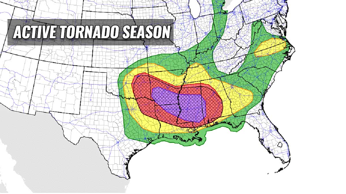
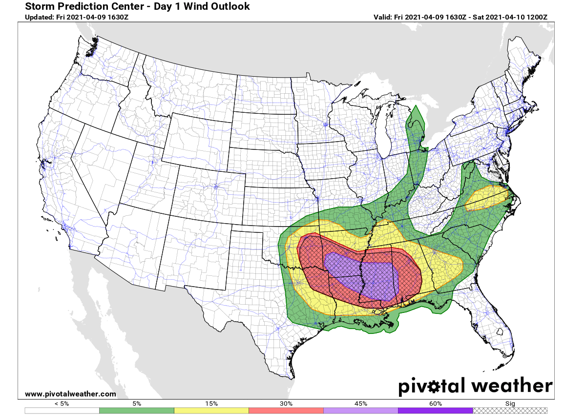
The Storm Prediction Center (SPC) has issued an MDT (moderate) risk for severe thunderstorms tonight. The highest risk stretches across the area from southern Arkansas, northern Louisiana to most of Mississippi state with potential growth for destructive winds.
Conditions are coming together for a possible derecho wind event across the Deep South, posing a risk for widespread severe damaging thunderstorms affecting hundreds of miles. Those could knock down trees and powerlines, potentially gusting above 70-75 miles across a broader area.
The Moderate risk (darkest and red/purple colors) covers the areas most likely to be affected. Weather models are forecasting an intense line of storms – a massive squall-line, racing from west to east across the risk area tonight into Saturday morning.
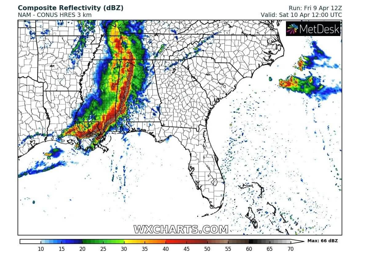
Some very intense storms are seen within the moving line by Friday night over Mississippi, reaching Alabama in the morning hours on Saturday. Potential damage could be significant and widespread along this moving convective line.
Following a quiet January and February, the first month of the meteorological spring 2021 was very active with severe weather and tornadoes. March brought the total number of tornadoes to 208, aligning it with the long-term average for the first three months of the year.
TORNADO SEASON ACCELERATES, THANKS TO TORNADO OUTBREAKS IN MARCH
Although the severe weather and tornado season had a quite slow start, March caught up with the statistics. The general trends seem to follow the earlier forecasts that severe weather season this spring will be an above-average, thanks to the still ongoing La Nina.
March has brought several very significant severe weather events, two of them had the highest threat levels issues – HIGH RISK, very rare for the month of March. Those were tornado outbreaks in the Dixie Alley on March 23rd and another one less than a week earlier, on March 17th.
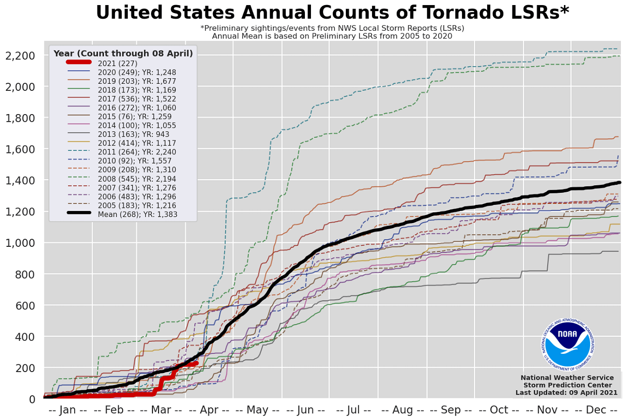
As of April 8th this year (the chart above), there were 227 tornadoes reported across the United States so far. The average number of tornadoes until Apr 8th is 268, so the tornado season this year is ranking at about 85 percent (%) of typical average tornado counts through January, February, March, and early April.
Now, we have entered the second month of the meteorological spring. In April, tornado activity typically increases and begins to spread farther north with the progress of the warmth and moisture recovery from the Gulf of Mexico, typically from the south into the Great Plains and the Midwest. April is the 3rd most active month for tornadoes besides May, which is considered as the peak month, and indeed June.
A similar activity to 2021 was also seen in the spring 2011 tornado season, as both the Mississippi and Tennessee Valleys were badly hit with destructive tornadoes. April is also known to produce significant tornado outbreaks that spread across multiple states due to the jet stream wind maximum being somewhat progressive in nature.
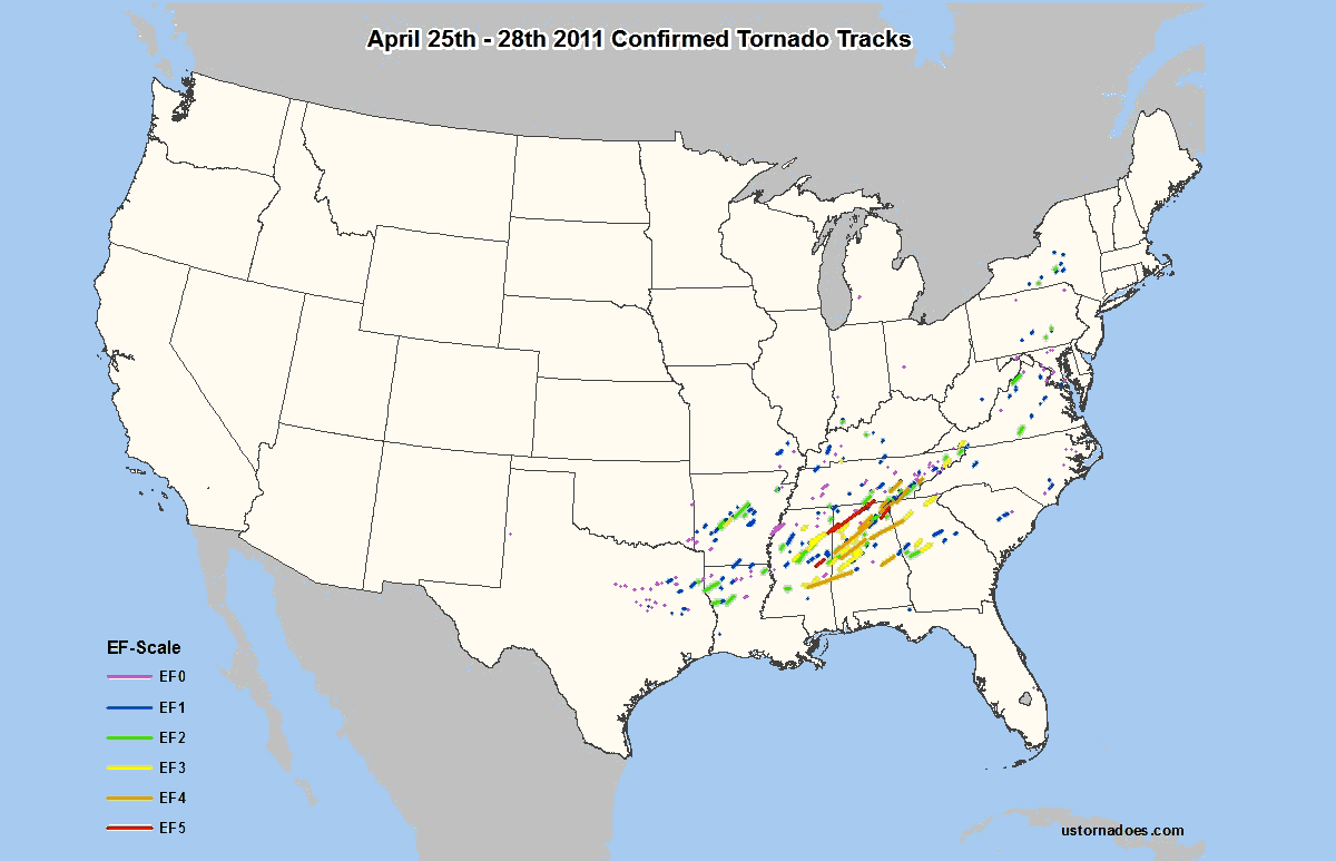
Remember: two Super Outbreak events with a huge amount of tornadoes, both occurred in April. One was on Apr 3-4th, 1974 while the most recent was 10 years ago, the tornado outbreak on Apr 27th, 2011.
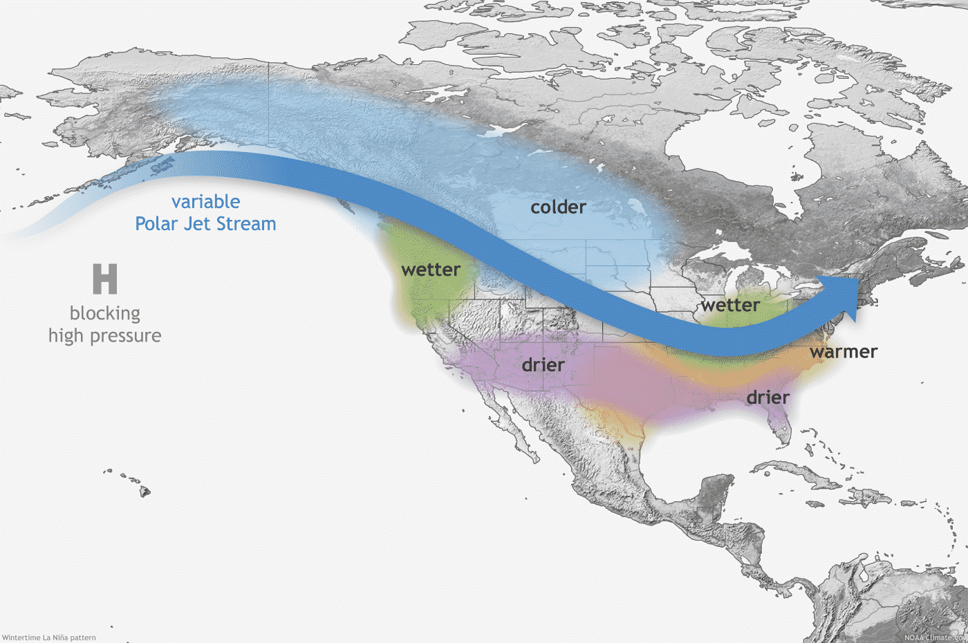
Thanks to the below-average sea temperature across the tropical central Pacific waters, known as La Nina, the spring months this year could trigger an above-average tornado season. These changing Pacific waters, known as ENSO (El Niño–Southern Oscillation) is a natural cycle and is known as one of the main drivers for the weather dynamics around the Earth.
Both well-known areas, the Tornado Alley and the Dixie Alley tend to get more dangerous severe weather when the La Nina phase is present. And in such kind of years, a tornado season starts typically brings about 4-6 weeks earlier activity. It also tends to have higher activity than normal.
Dixie Alley and the low-mid Mississippi Valley could be one area to focus on this year, as we have already seen during the month of March when two tornado outbreaks occurred. These areas of the United States receive more tornadoes in La Nina years than during a normal year.
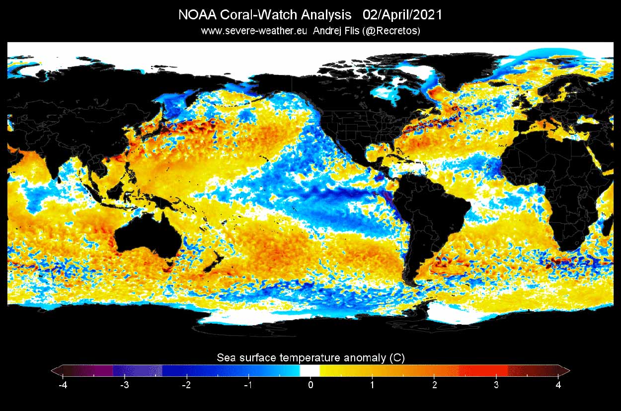
As we have seen from the chart above, the Gulf of Mexico and the Caribbean Sea are both warmer than average. The water temperatures over the region were more than 1 degree Celsius above normal for early April. This is quite a concerning indicator for the ongoing tornado season as the higher moisture associated with warmer waters then gradually spread towards the north, across the Great Plains and the Mississippi Valley.
ABOVE-NORMAL TORNADO SEASON VERY LIKELY TO CONTINUE
Typically, during the La Nina years, the jet stream is stronger across the United States which gives a hint at what’s coming up ahead for this tornado season. It is indeed not that simple, of course, but according to what we have seen so far and to the general forecast trends, the tornado season will continue to be very active through spring this year.
Although the La Nina is forecast to generally weaken over the next months, the overall favorable progressive pattern seems to also continue and extend into May, so the tornado season will keep storm chasers very busy this spring.
Recent studies also suggest that the main activity through the tornado season might be well off the traditional Tornado Alley – the area covering the southern and central United States into the Midwest with an annual high frequency of severe weather hazards and tornadoes.

The main activity might well be shifted into the low-mid Mississippi Valley and the central Gulf Coast this year. This correlation mainly goes in line with the La Nina pattern being active, which tends to bring the highest frequency of severe weather further east.
However, it of course does not mean the traditional Tornado Alley will not see tornadoes but it might just keep the tornado numbers below average this spring.
With the gradual northward retreat of the upper-level jet stream above the strong temperature contrast below, the states around the Mississippi river up towards the Tennessee valleys and east to Alabama might be in higher threat through the end of April. Basically, the area being known as the Dixie Alley, often experiencing deadly tornado outbreaks in the past.

When the spring goes deeper towards the month of May and June, the typical northward shift of the jet stream occurs. But the winds will likely remain stronger than normal, so the tornado season will probably continue as above-average during the peak period, that is mid-April to mid-June. The chart above is a typical map for the mid-season, middle May, based on the long-term average severe weather occurrence across the U.S.
Nevertheless, the potential areas with the highest number of tornadoes this year are quite unfriendly for the local residents when tornadoes occur. The Mississippi Valley is full of trees and high humidity most of the time, so tornadoes are even more dangerous as they are hardly seen in the misty air mass with numerous trees obscuring the proper view on the incoming danger. Tornadoes are normally quickly seen on the flat open fields of the Great Plains (Tornado Alley).
ANOTHER SEVERE WEATHER OUTBREAK ACROSS THE SOUTH THIS WEEKEND
It appears likely that multiple episodes of severe thunderstorms are expected to take place from parts of eastern Oklahoma and northeast Texas across the Mid-South and Mississippi Delta regions, to parts of Alabama and Georgia tonight into Saturday morning. This includes a threat for a swath of severe wind from Arkansas across the lower Mississippi Valley. Large, damaging hail and tornadoes also are possible.
The combination of strong instability and enhanced deep-layer shear will support both organized clusters and isolated/scattered supercells, with fairly rapid upscale growth into a convective line expected by this evening along the racing surface cold front. Thunderstorms will surge southeastward from eastern Oklahoma into southern Arkansas and northeast Texas tonight.
Large hail and swaths of damaging winds, some significant, appear likely, as well as the potential for a few tornadoes with embedded circulations as convection continues overnight across Louisiana and Mississippi, potentially into Alabama by mid-Saturday morning.
This chart above, pointing at an intense squall-line, raising concerns for a derecho wind maximum to develop along the front.
***A derecho is a thunderstorm complex with significantly severe and widespread thunderstorms that travel long distances and last duration for hours along the front. And could result in a large and wide wind damage swath, often observed with mesoscale convective systems (MCS), more typical for late spring and summer months.
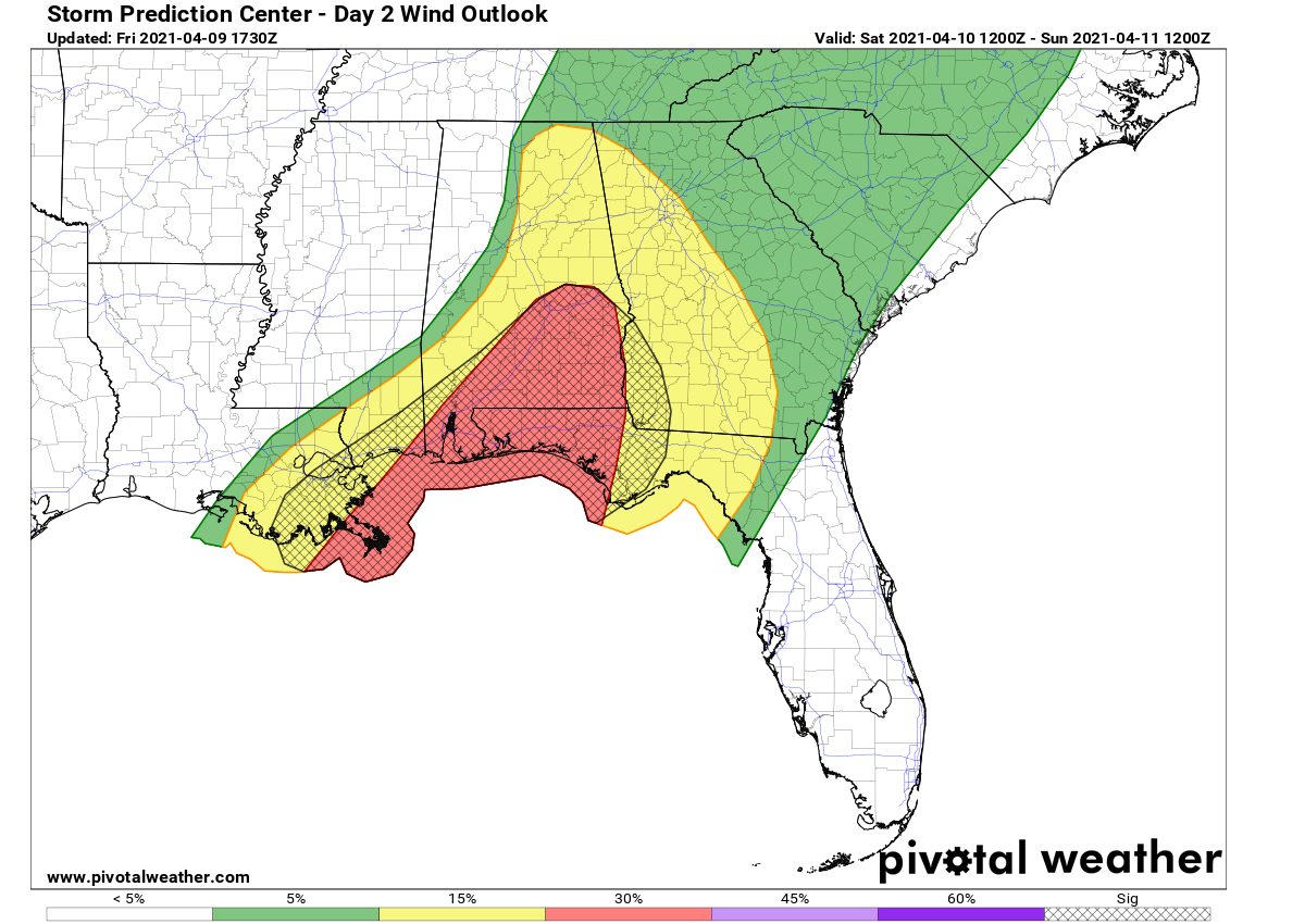
Thunderstorms organized into an intense line will reach central Alabama by late Saturday morning, continue east-southeast throughout the day. Bringing damaging thunderstorms also to Georgia and central portions of the Florida Panhandle by the Saturday afternoon hours.
The SPC has included these areas into an ENH (Enhanced) threat level, as again damaging winds, torrential rain, large hail, and a few tornadoes are possible.
By the Saturday evening hours, the organized severe weather threat will gradually diminish while storms/squall-line will be going offshore into the Atlantic. Cooler temperatures and drier weather will spread behind the front from the northwest.
The overall activity across the Deep South and the Southeast United States will worsen the ongoing flooding threat, thanks to the high level of moisture present with the warmer Gulf of Mexico this tornado season.
Might this affect the upcoming hurricane season as well? The first model guidance suggests that the 2021 season could *again* be above average, like last year. We will have a special update on this matter in the coming days – stay tuned!
Don’t forget to bookmark our page to have all the new info ready at hand. Make sure to bookmark our page, or click on ‘show more‘ if you are reading this article from the Google Discover feed.
***The images used in this article were provided by NOAA, Pivotalweather, and Wxcharts.