Another significant Winter Storm Marisol will develop over the United States on Friday. A bomb cyclone rapidly develops while a deep upper wave moves across the central U.S., forecast to deliver an intense snow blizzard to the Northern Plains and the Upper Midwest. For the Central and Southern U.S., a widespread severe weather outbreak will occur Friday through Saturday.
The weather pattern across the North American continent has become progressive and dynamic as the calendar emerges into a Meteorological Spring season in 2025.
A deep cold wave will move across the nation late this week, developing a bomb cyclone racing across the Central United States. An associated Winter Storm Marisol will cause an intense snow blizzard in the northern States and a two-day severe weather outbreak across the Mississippi Valley and Southeast U.S. on Friday and Saturday.

On Thursday, a significant frontal system will emerge from the Pacific into the West Coast, bringing intense snowfall across the Sierra mountains and heavy rain to California. On Friday, the deep trough will move across the Rockies and emerge in the Great Plains.
Weather conditions will rapidly deteriorate as a bomb cyclone occurs. Surface pressure will quickly deepen once the upper wave/trough ejects the Rockies.
The video animation below provides a quick overview of the storm dynamics across the Contiguous U.S. this week. On Friday, an intense winter storm will push central pressure to near 970 mbar over the northern Great Plains, producing severe weather outbreaks across the South and snow blizzards across the North and the Upper Midwest.
Let’s examine the details of Winter Storm Marisol’s evolution. Tens of millions along the storm’s path will experience significant weather conditions from Thursday through Saturday. The storm will impact the West Coast to the East Coast.
A deep wave emerges into the U.S., bomb cyclone and Winter Storm Marisol impact on Friday
A deep upper wave emerges from the North Pacific into the West Coast on Thursday and will continue east across the Rockies on Friday. It will appear over the northern Great Plains early Friday and deepen further. A significant cold core will develop, introducing a sharp pressure and temperature gradient towards the ground.

An associated surface low will occur over Colorado, Kansas, and Nebraska. It will rapidly strengthen and push its central pressure into the low 970s, continuing to strengthen into a Winter Storm Marisol. The low will move northeast across the Midwest Friday through Saturday and reach southern Ontario, Canada, early Sunday.
It is forecast to reach a mature stage and deepen its central pressure to near 970 mbar or even lower by Friday night, fully developed as a powerful winter storm. Weather conditions will be extreme on both the cold and warm side of the low.

Friday night, the low will be located over central Kansas and Missouri, and a cold front will accompany it from grazing into the warm sector with a much warmer air mass across the southern States. A widespread severe weather outbreak is likely to develop. Severe thunderstorms will pose a threat of tornadoes, large hail, and damaging winds.
On the cold side of the winter storm, snowfall will intensify across Colorado and Wyoming into western Nebraska and the Dakotas through Saturday morning. The snow blizzard will significantly intensify across the Northern Plains and Upper Midwest Friday night into Saturday. Intense snowfall with near-zero visibility is expected.
Due to the intense pressure gradient around the surface low, severe winds will develop across the High Plains on Friday and continue overnight into Saturday as the center low moves northeast.

Ahead of the deep trough and the surface low, a much warmer air mass will be dragged from the south onto the Great Lakes region and Ontario, Canada, introducing a sharp contrast towards the cold side of the cyclone to the west.
This is also why the weather conditions will be wild and rapidly changing while the winter storm advances across the U.S. on Friday.
However, a pretty warm day is expected ahead of the low across the Great Lakes and Northeast U.S. before it emerges from the west Wednesday night.

Fresh snow is forecast to accumulate from the Rockies across the Dakotas to Minnesota and western Ontario, Canada. This aligns with the timing and path of the winter storm, which will develop on Friday and move across the nation through Saturday night.
Heavy snowfall will accumulate across the Northern Plains and Upper Midwest. By Saturday night, there will be around 6-10 inches of fresh snow locally.
Expect significant traffic interruptions from heavy snow and near-zero visibility from blowing snow with intense snow blizzard developing.

The following 2m temperature chart indicates that strong southern winds will drag higher temperatures across the warm sector ahead of the surface low on Friday.
This will result in a warm day far north toward the Upper Midwest and the Great Lakes. Conditions will become unstable as high moisture will also be absorbed from the deep South.

Through Friday night into Saturday, a much warmer and moist air mass across the warm sector over the central and Southeast U.S. will fuel the eastward-racing severe thunderstorms along the leading cold front.
Winter Storm forecast to produce a Severe Weather Outbreak across the Mississippi Valley and the Southeast U.S.
A combination of a significant upper cold wave, clashing with warmer sub-tropical air mass, a vigorous frontal system develops. A winter storm Marisol will introduce a widespread severe weather outbreak across the Central and Southeast U.S., from eastern Texas and Oklahoma to the mid- and lower Mississippi Valley on Friday night.
With the deepening of the low, conditions will rapidly deteriorate on Friday afternoon as the winter storm advances northeast. A sharp pressure and temperature contrast throughout the atmosphere will strengthen the jet stream aloft, supporting organized severe storms along the front.

Friday night, significant severe weather, including scattered supercell thunderstorms, is forecast across Iowa and Illinois into southern Minnesota near the center low. Those could be tornadic, with strong shear in place, combined with a very warm air mass rounding the core.
Overnight to Saturday morning, severe storms across the south will continue east from Louisiana into Missisippi and Alabama. Widespread outbreaks of intense supercell storms with tornadoes, severe winds, and significant hail events are possible.

This will provide a volatile, sheared environment for strong tornadoes and damaging winds with the most intense thunderstorms.
You will notice powerful winds in the wake side of the low across the High Plains. Peak wind gusts are likely to reach 70-80 mph in some areas.

Attached is a probabilistic outlook issued by the Storm Prediction Center (SPC) for Friday afternoon and night hours. A widespread severe weather outbreak is expected to develop along the leading cold front moving east.
Severe thunderstorms pose a significant risk of tornadoes (including strong ones), large hail, and severe winds.

The convective activity along the cold front racing across the South and Southeast U.S. will continue east on Saturday. A potential severe weather outbreak will continue across Alabama and Georgia, extending to the East Coast and the Carolinas.
Due to the fast-moving winter storm, the amount of rain along the frontal system will be the most significant where intense thunderstorms and clusters will develop. From Thursday through Saturday, 2 to 4 inches of rain can accumulate across the South and Southeast U.S.

The highest precipitation amounts are forecast across Mississippi, Alabama, Tennessee, and Georgia.
Deep low flips temperatures from spring to winter over the Great Lakes and Northeast U.S. after Sunday
The winter storm Marisol will mature by Saturday night, meaning its central pressure will start rising while the low will be ejecting Wisconsin and Minnesota to Ontario, Canada.
It will begin a weakening phase on Sunday while dragging significantly lower temperatures back into the region.

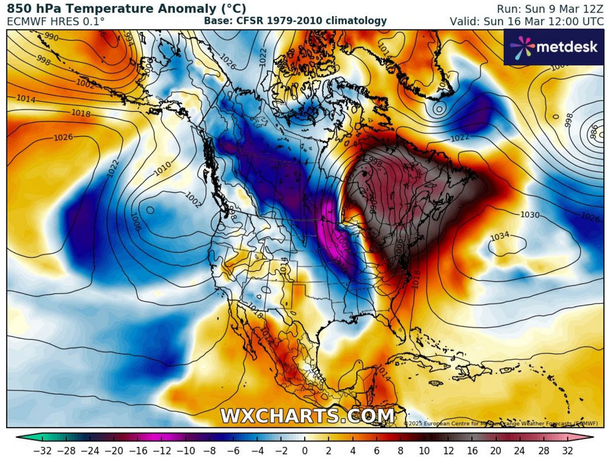
The cold blast associated with the system will spread from Saskatchewan and Manitoba into the Dakotas and Upper Midwest states by Sunday morning. The following image shows a high contrast —25 °C warmer than usual ahead of the low and 10 °C below normal in its wake.
Cold temperatures will also spread across the Great Lakes and Northeast U.S. Sunday through Monday, replacing the significantly too warm air mass with wintry cold again.
Conditions will gradually warm up again through the middle of next week.
We are closely monitoring the evolution of the ongoing pattern and will update you accordingly. Stay tuned.
Wxcharts, Windy, and Pivotalweather provided images used in this article.