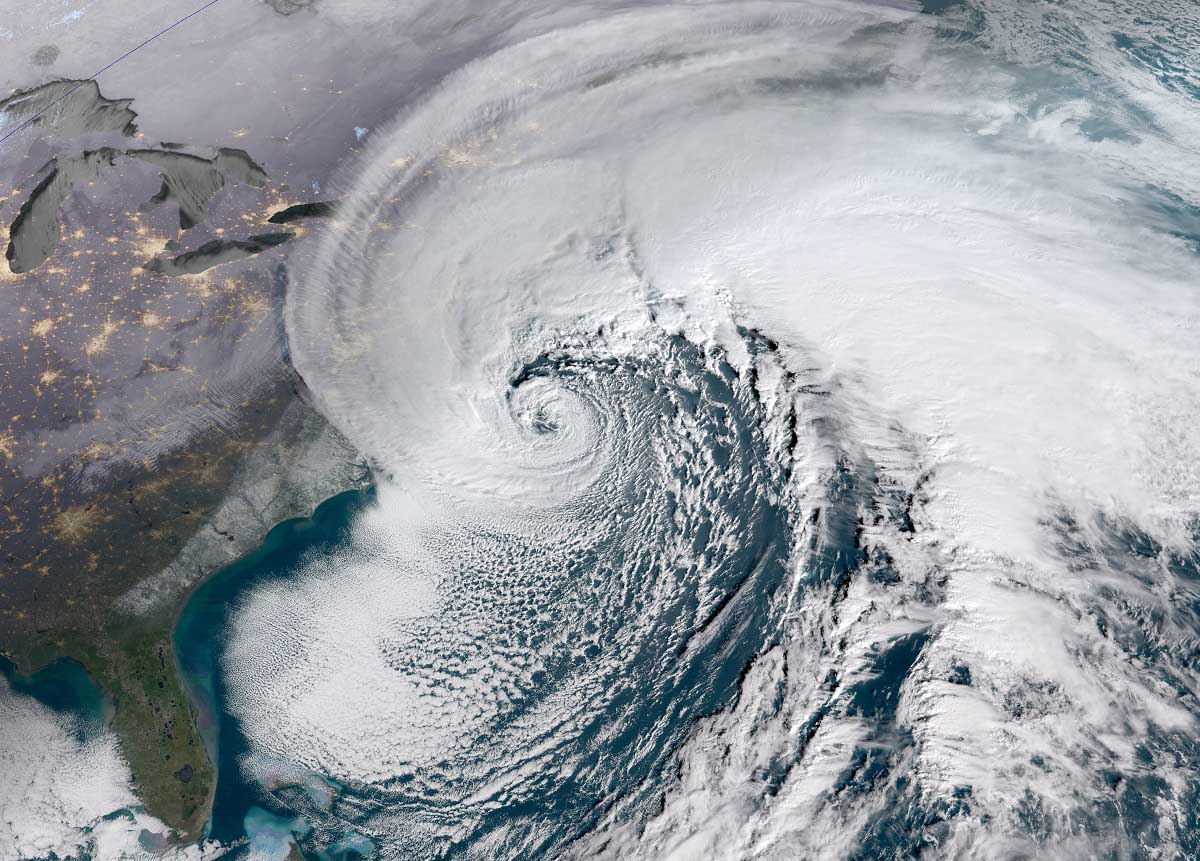
A historic Winter storm Landon has brought record snow and damaging freezing rain in parts of the U.S. and Canada on Friday, the system is now heading into the North Atlantic. It will, thanks to the deep southern lobe of the Polar Vortex above, rapidly intensify into a new bomb cyclone. Becoming the most intense extratropical storm of the Winter Season 2021/22 for the region. Violent winds with deep snow and blizzards will blast Iceland and southern Greenland on Monday.
The general pattern that sparked the season’s strongest winter storm Landon across the U.S., is now ejecting the system towards the European land. The system that brought damaging freezing rain and deep snowpack from the South towards the Northeast states and eastern Canada, is expected to become the next Atlantic bomb, deepening into the 920s by Monday and dumping deep snow to Iceland and Greenland.
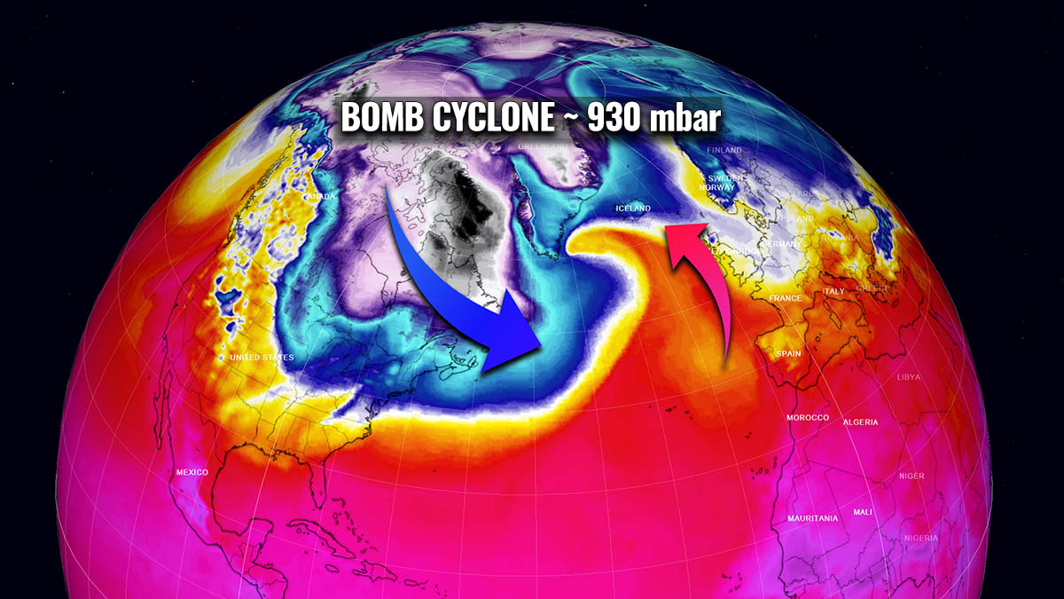
The North Atlantic has actually turned into a pretty dynamic weather pattern just recently, after being quite calm under the influence of strong blocking Highs. Thanks to the southern lobe of the Polar Vortex being particularly deep this Winter Season 2021/22, a violent extratropical storm is forecast to develop south of Greenland on Sunday, turning towards Iceland on Monday.
Although the North Atlantic region has actually been lacking particularly intense extratropical storms this winter season, this one will be pretty violent and become the most intense so far. From both the wind intensity, its central pressure, and the size. The water vapor satellite does indicate a monster in development is around the corner.
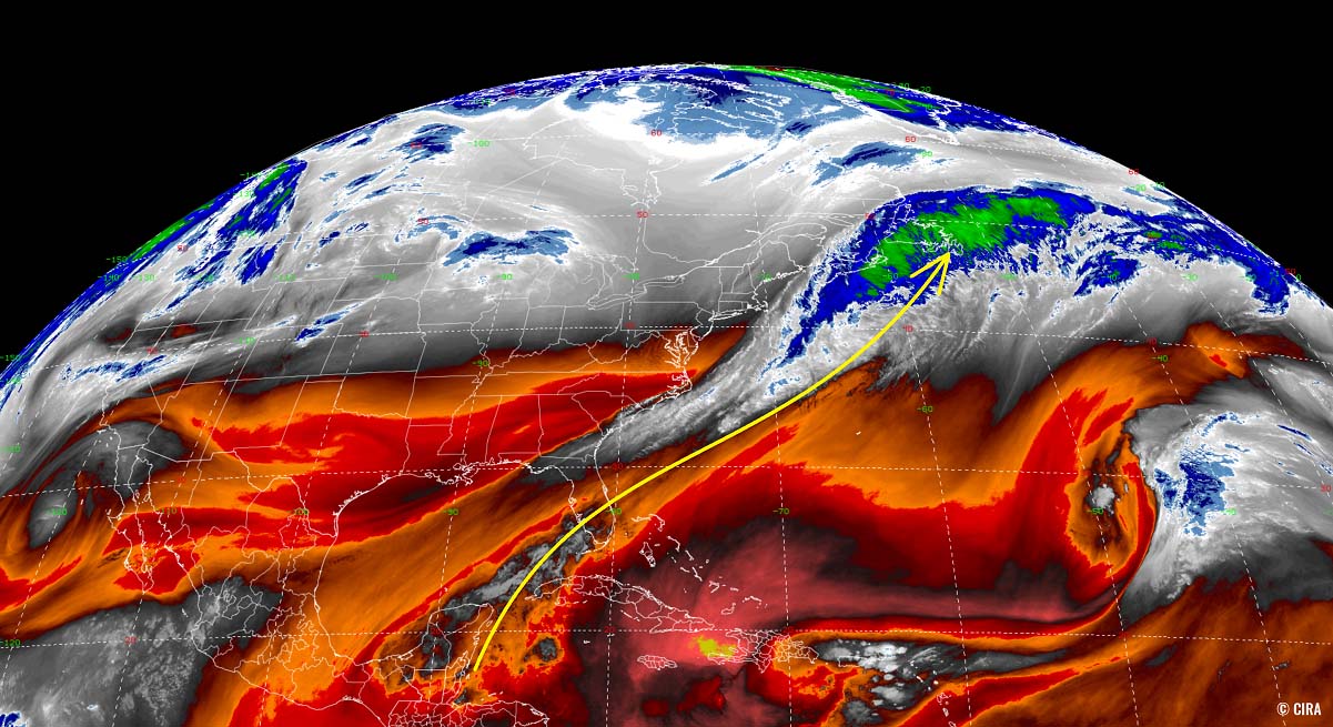
It reveals the textbook structure of the initial stages for cyclogenesis after the intrusion of much colder, Arctic air mass from the continent into the ocean. A huge moisture advection is underway this weekend, dragging the air mass from the deep tropical region towards the Northwest Atlantic. A hint of how wild the upcoming 48 hours will be in this part of the Atlantic.
The new monster storm is forecast to considerably deepen (more than 70 mbar in 48 hours) through Monday morning and blast southern Greenland and Iceland with destructive winds, major waves, deep snow, and blizzards. The video animation below hints at the rapid development of this cyclone as it ejects off eastern Canada and continues towards northwestern Europe.
This new violent Atlantic storm will therefore be explosive in nature, generating hurricane-force winds with the highest gusts peaking above 200 km/h (125 mph).
Again, as it often happens during winter months, the main driving factor behind the cold outbreaks that lead to the development of violent extratropical storms is the Polar Vortex above us. It has been particularly intense this winter season and is showing no signs of weakening in the coming weeks.
THE POLAR VORTEX
If we take a look at how the Earth’s atmosphere is built, we have six layers that are rounding our planet. Most of the weather for our lives occurs within the lowest two layers, known as the troposphere and the stratosphere layers.
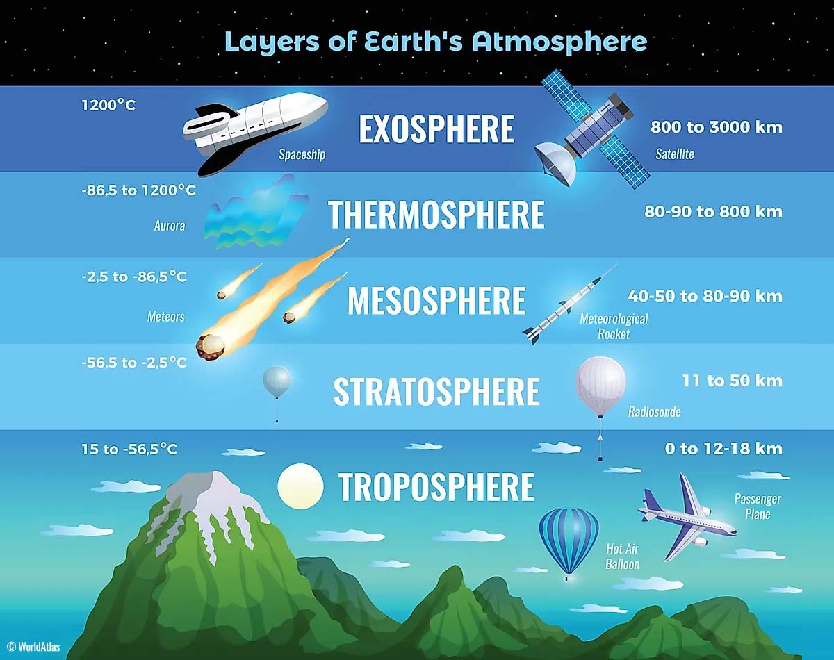
The lowest is the troposphere layer, where all the weather we encounter takes place. The troposphere layer extends from the Earth’s surface (or sea level) up to 12 km into the sky. The troposphere’s depth varies between 8 km to about 20 km, depending on where you live. It is the deepest above the equator, but it gets thicker above the North Pole.
The layer above the troposphere is a much deeper one, we know it as the stratosphere layer. The stratosphere is about 10-50 km thick and it is also very dry. Also, the Ozone layer is found here, the one that has a vital role in the protection of our planet’s life.
An important part in the stratosphere above us, that drives the dynamic patterns in our weather, is known as the Polar Vortex. The Polar Vortex is a very large, three-dimensional ring of pretty powerful winds above our heads. It surrounds both the North and South poles and is rotating roughly about 20-50 km above the Earth’s surface. Typically, the Polar Vortex is the strongest during the winter months.
Note that both, the troposphere and the stratosphere layers, are very crucial for our planet’s climate. The Polar Vortex literally covers most of the bottom half of our atmosphere, from the middle of Earth’s troposphere up into most of the stratosphere layer. So as it is strongest during the winter months, it has an important role in the winter weather across the high and mid-latitudes. Indeed across all three continents, North America, Europe, and Asia.
As we learned, although the Polar Vortex spins very high up above our heads, it remains directly connected to the lower part of the atmosphere. Thus, it gives our daily weather a shape most of the time, as it works as one very large hemispheric circulation.
So, how the Polar Vortex actually forms?
From the autumn months (mid-September through November), the polar regions in the northern hemisphere receive much less sunlight over time. This happens because a stronger inclination of the Earth’s axis occurs. The North Pole is set into the position that it starts to significantly cool down, so polar nights without any sunlight occur for several months there.
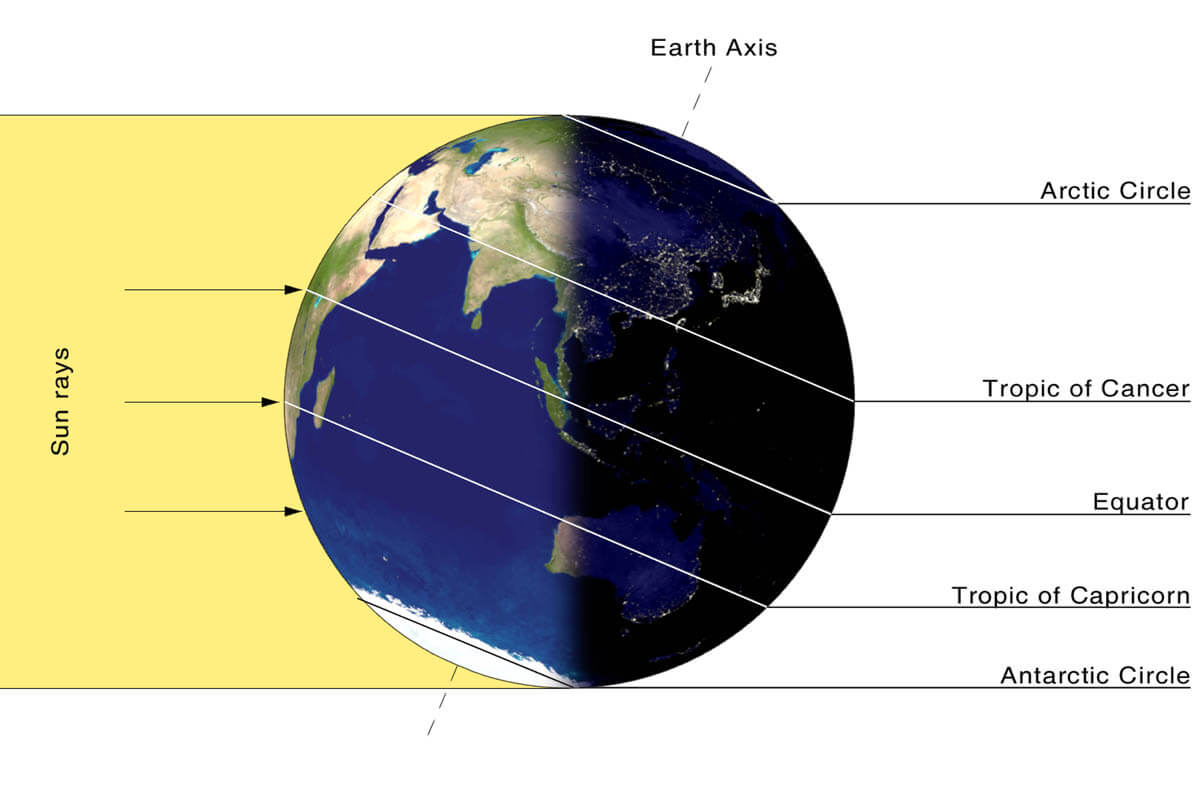
While the northern polar regions are getting cooler with time, the atmosphere layer further towards the south remains pretty warm. So as we head deeper into the winter months, the southern regions continue to receive way more sunlight and energy from the Sun compared to polar regions farther north.
Finally, the cooler temperatures across the polar region translate into lowering the surface pressure, a similar process also occurs in the stratosphere layer above. Therefore, the increase in the temperature difference between the North pole and the equator occurs, leading to a development of a large low-pressure cyclonic circulation across the polar stratosphere.
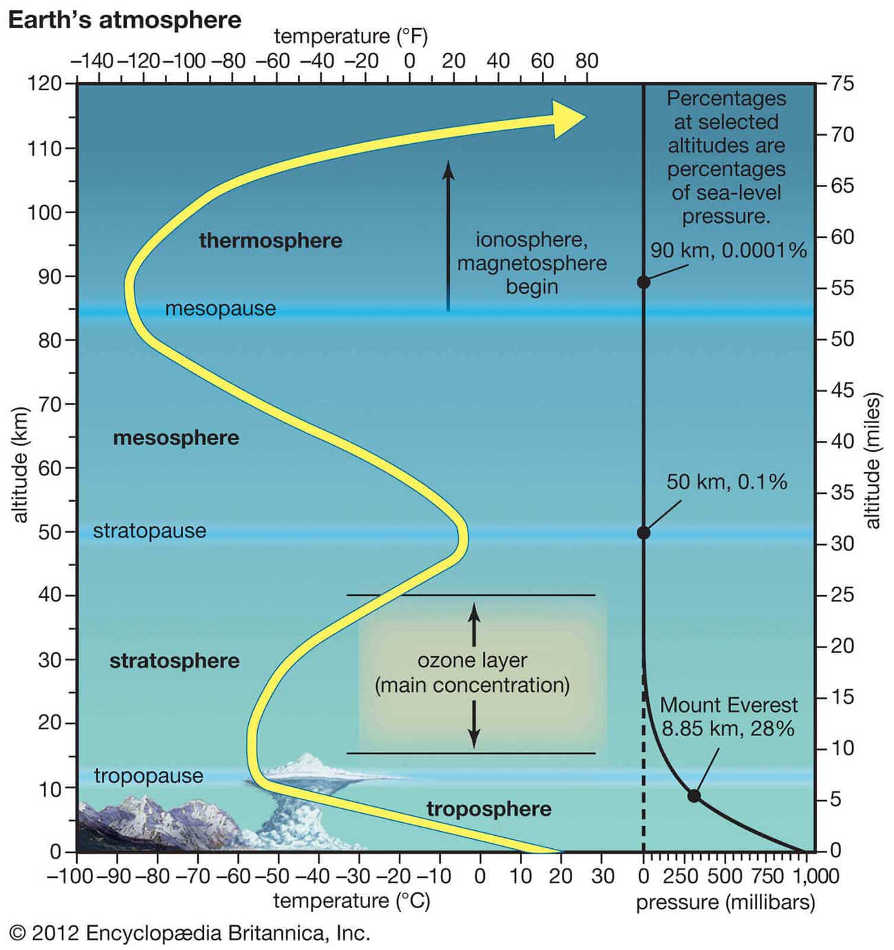
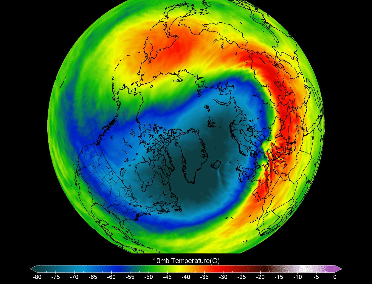
To conclude, the Polar Vortex itself is acting as a very large cyclone and it covers the whole polar region, spread down to the regions in the mid-latitudes. Note that the same happens in the southern hemisphere as well. The attached chart above is showing a textbook example of the Polar Vortex placed above us, it is located at around 30 km (18 miles) altitude. That is very near the top of the stratosphere during the winter season.
Compared to recent years, the Winter Season 2021/22 has a very strong and active Polar Vortex aloft. Many of the Arctic cold outbreaks and winter storms we hear developing into Canada, the United States, Asia, or Europe, are triggered by the activity aloft.
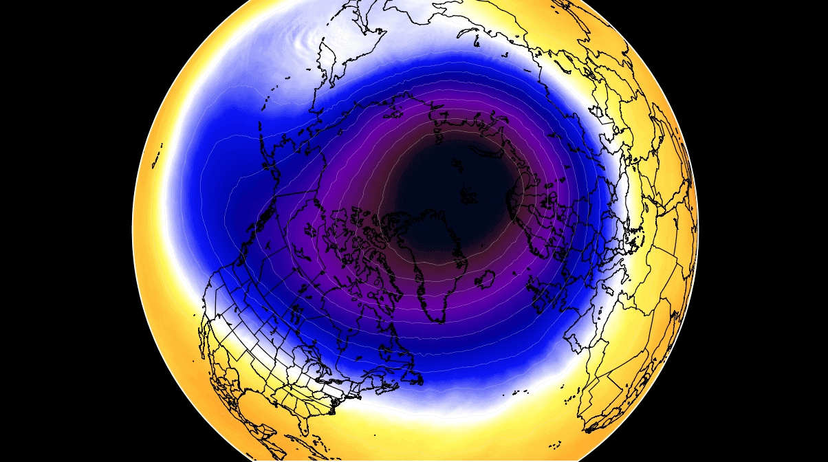
Also these days, the major weather change that occurred over North America was led by the Polar Vortex above. And after leaving deep snow cover and a lot of freezing rain across a large part of the U.S. and Cnada, the southern lobe of the vortex is now ejecting a very deep trough into the Atlantic Ocean. It will be a trigger of the most intense extratropical storm of the Winter Season in the region.
As it happens quite often during the colder part of the year, powerful intrusions of the very cold, Arctic air masses lead to the development of deep cyclones over the warmer Atlantic. This time, the result will be an explosive Atlantic storm, that will rapidly intensify. It will develop so fast, that it will be classified as a so-called bomb cyclone.
Have you ever heard of those and how dangerous they are? Let’s find out.
A BOMB CYCLONE – HOW SUCH POWERFUL STORM FORMS?
The North Atlantic sometimes develops some very powerful storms, they look impressive on the satellite. But are also very dangerous, and meteorologically speaking, also very didactic and outstanding with their development. Normally, when such a pressure change that is forecast from Sunday to Monday occurs, it means that the system could be classified as a bomb cyclone.
In other words, the surface low intensifies so fast that its central pressure is falling very (or often extremely) rapidly. A bomb storm develops when explosive cyclogenesis with the extremely rapid deepening of its barometric pressure occurs. This is known as the bombogenesis process.
Technically, a pressure fall of at least 24 millibars within 24 hours is the leading criteria that the cyclonic system needs to meet that can be officially classified as a bomb cyclone. It is a non-tropical storm, also known as an extratropical low. It develops extremely rapidly from a classic low-pressure system. An example of such bomb cyclones is seen above, this is a typical Nor’Easter along the U.S. coast, similar to the one that occurred a week ago.
Extratropical storms normally grow very large, dominating a large portion of the Atlantic ocean (or the North Pacific on other occasions). The general movement of these types of cyclones in the Northern hemisphere is towards the northeast. The cyclone’s large size produces very intense and often extremely severe, hurricane-force winds. It generates major waves and swell across a broad area and threaten marine traffic.
Similar to the classic extratropical cyclone, bombs are fueled by variations in the temperature, between the warmer temperatures over the Atlantic coming from the Equator and much cooler temperatures towards the Arctic region. This also occurs vertically throughout the atmosphere.
Note, that these types of cyclones are different from tropical cyclones that we normally see during the Atlantic hurricane season. Those receive their fuel energy from extremely warm sea surface temperatures found in the tropical region.
Typically, the east coasts of the North American continent and Northwest Atlantic Ocean are the perfect breeding grounds for these types of cyclones during the late autumn/fall and winter months. There, an interaction of the Arctic cold continental air mass and warmer, moist ocean tropical air mass provides a lot of energy for cyclonic systems to rapidly develop. They often literally explode over the Atlantic.
Bomb cyclones are actually quite common during the winter months in the North Atlantic, although they can occur all year round. These, so-called ‘bombs’ also include post-tropical systems that sometimes rapidly reform from a decaying tropical cyclone when they travel far north towards Europe.
Statistically, there are about 60-70 such cyclone-type formations on Earth every year. About two-thirds of them occur in the Northern Hemisphere, particularly off the east coasts of the U.S. and the North Atlantic.
The other bomb cyclones are found in the northwestern Pacific around Japan, these two regions are prime for these systems. Even Australia can get several of them each year, although they rarely have so rapid intensification as the Atlantic or Pacific storms.
POLAR VORTEX BLAMED FOR ANOTHER BOMB CYCLONE THIS WINTER SEASON
Pretty similar as we have seen at the end of January’s bomb cyclone and violent Nor’Easter along the Northeast U.S. coast, the trigger behind this upcoming monster North Atlantic low is yet again a Polar Vortex aloft. Being so particularly strong this Winter Season 2021/22, it drags outbreaks of very cold, often frigid cold Arctic air mass across the North American continent into the Northwest Atlantic.
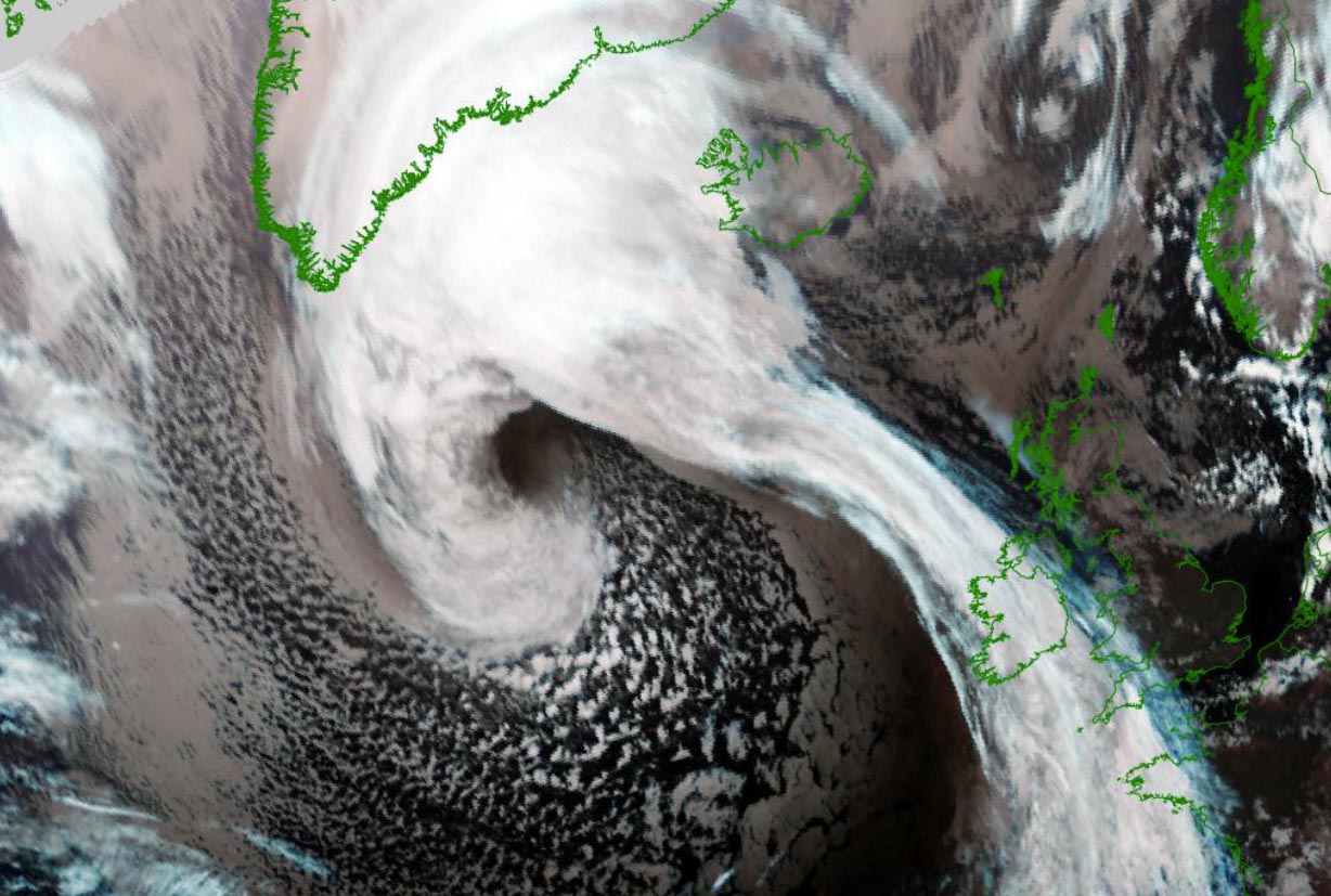
This is just another perfect recipe for the Polar Vortex to trigger an explosive development of the extratropical low as a major trough from eastern Canada finally ejects into the Labrador Sea and the Atlantic. The visible spectrum satellite image from this Saturday is revealing a very impressive, yet textbook example of the developing storm.
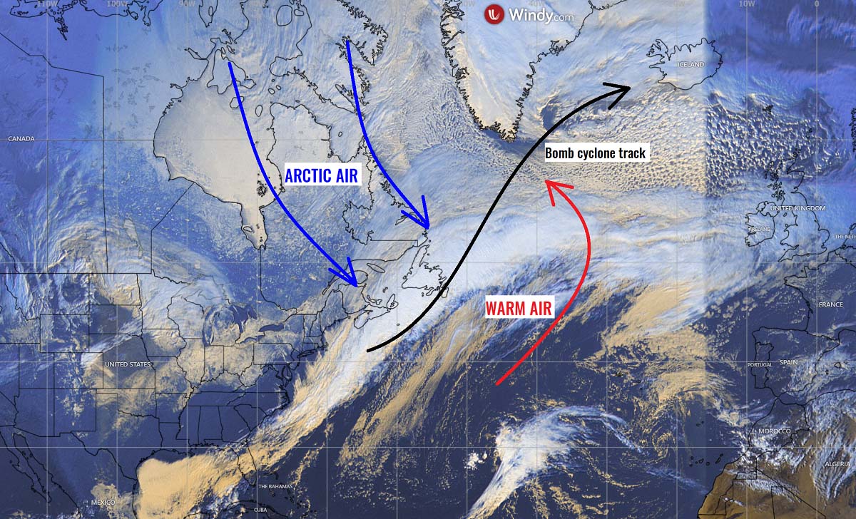
A massive baroclinic zone is stretching on the nose of the Arctic cold over the far Northeast U.S., pushing the departing storm across Newfoundland towards the open Atlantic Ocean. A battle of two huge reservoirs of Arctic cold versus the warmer and moist sub-tropical air will occur on Sunday, leading to literally an explosive development of a bomb cyclone.
As with the rather typical process of this kind of system, the low will be undergoing a bombogenesis phase for about 24 to 36 hours, starting Sunday morning. It is forecast to mature into a violent extratropical storm by Monday morning. We can expect that its structure will be pretty spectacular at the peak intensity.
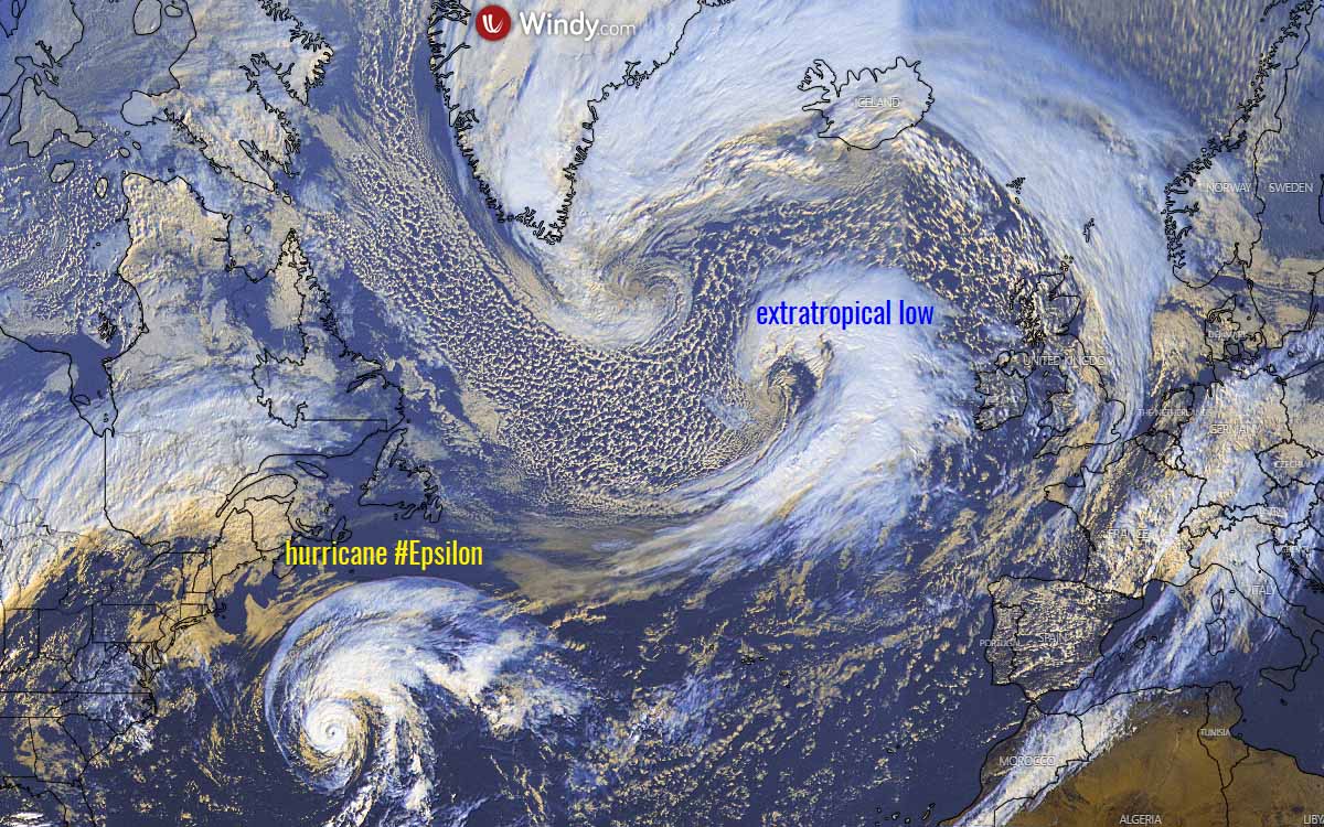
Satellite images typically reveal an appearance of the cloud bands symmetrically wrapped into a tightening core when this occurs. The example below is such a system back from October 2020.
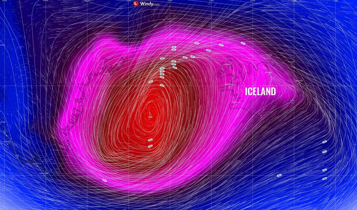
The NOAA Ocean Prediction Center (OPC) analysis on Saturday 12 UTC (left chart below) has revealed that the system has a central pressure of 1002 mbar, centered over Newfoundland, Canada. We can nicely see a baroclinic zone with the surface fronts extending the cold off the U.S. East Coast and the warm front advecting north ahead of the re-developing low.
The chart already hints at a rapid intensification process forecast within the next 24 hours, so by Sunday morning the low should begin and deepen to mid 970s according to the OPC forecast. The right chart is valid for Monday 12 UTC, so 48 hours ahead of the left one. Can you spot the difference? A massive 1040+ mbar High develops under the Arctic blast in southeastern Canada, while the extratropical storm deepens for another 40+ mbars into the upper 920s along southern Greenland.
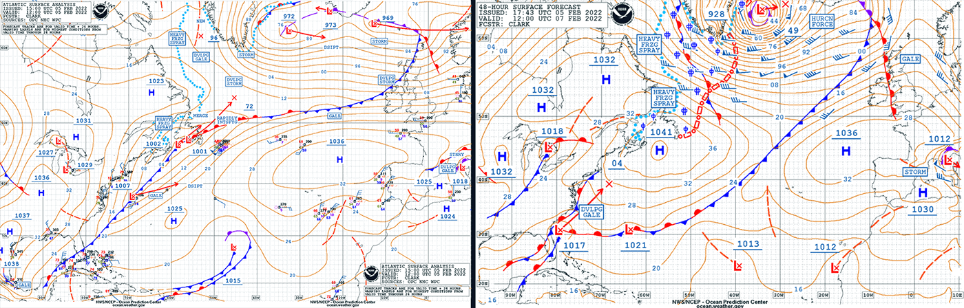
The heavy freezing spray will develop with severe winds in the system’s wake, blasting the eastern Newfoundland and the southern Labrador Sea up to the southern tip of Greenland. Marine traffic crossing this region from Sunday into Monday will be battling some incredibly dangerous conditions of violent winds, freezing spray, and monster 15+ meter waves.
So, as we can judge from the forecast above, the central pressure in this extratropical storm should have an impressive 74 mbar drop over the next 48-hour period, between Saturday 12 UTC and Monday 12 UTC. Remember the criteria for a bombogenesis pressure change of 24 mbar in a 24-hour period? Our system will reach more than triple the threshold for explosive cyclogenesis this weekend.
So the overall process of rapid intensification basically starts on Sunday morning, when the surface low begins deepening its central pressure in a faster fashion. Around 975 mbar should be in the cyclone’s center around Sunday 12 UTC, explosively deepening to near 940 mbar by Monday 00 UTC. That’s astonishing near 35 mbar pressure drop in just 12 hours.
That’s really an explosive development at its finest! From Monday morning into midday, the central pressure will continue deepening but the most rapid intensification will end. Pressure should bottom out at around 925 to 930 mbar. The pressure change is, however, pretty remarkable throughout the whole rapid intensification process.

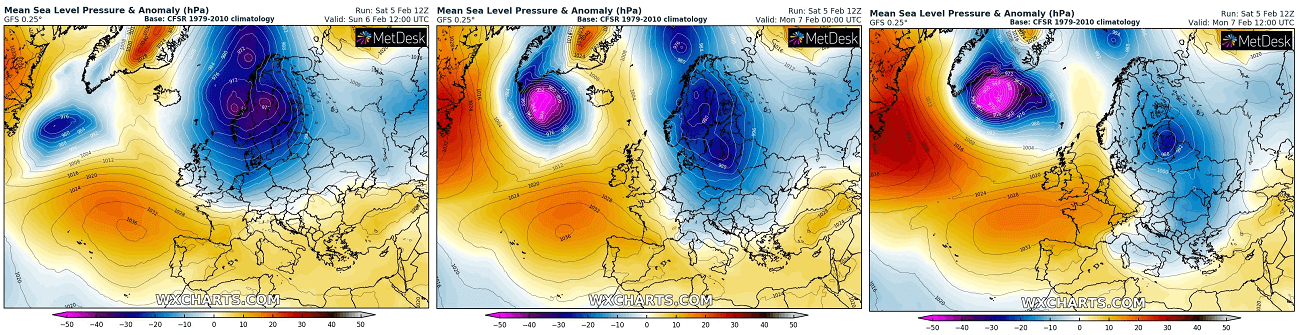
The wider view of the surface pressure extrapolations on Monday (chart above) can show us how huge a pressure difference is between the center of the low and the surface High forming over Newfoundland on Monday. More than 110 mbar pressure difference, can you imagine the violent winds in between these two large-scale features? The jet stream will be very intense also for the crossing air traffic!
TEXTBOOK EXAMPLE OF OF A WARM SECLUSION IN THIS LOW
While the much warmer weather will spread into western Europe ahead of the North Atlantic low, the northwesterly winds will drag the Arctic cold air mass into the Northwest Atlantic in the cyclone’s wake. A pretty didactic fluid dynamics chart of how the large-scale processes as the lobes of the Polar Vortex above us lead the ongoing weather system across North America, the Atlantic, and Europe.

The impressive temperature contrast picture above is also pretty textbook when it comes to the violent extratropical lows in the North Atlantic. There will be extremely cold Arctic air spread across eastern Canada, with temperatures even below -40 °C in places, nosing down into the northwestern Atlantic.
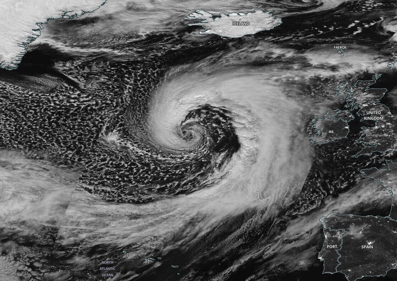
Farther east, the violent force of the exploding low will do the contrary. A very strong warm advection of subtropical air mass will be dragged very far north, rounding the center low with a classic comma shape of the temperature map. This is known as warm seclusion, defining the mature phase of the extratropical cyclone lifecycle is near.
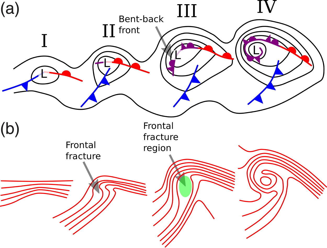
Warm seclusions may have cloud-free, eye-like features on the satellite imagery at their center, and can sometimes be reminiscent of tropical cyclones. It indicates that the system’s warm-core center is surrounded by hurricane-force winds along the bent-back warm front as seen on the chart above. After this phase, the mature stage is in full mode, so a storm starts its decaying process and no further intensification is possible.
Nonetheless, these systems and patterns are actually quite classic during winter months for the North Atlantic, following soon after intense Arctic outbreaks from Canadian Arctic and Greenland penetrate onto the much warmer sea waters. That’s how those wild marine videos you might’ve seen occur when ships are literally bouncing like toys in the ocean.
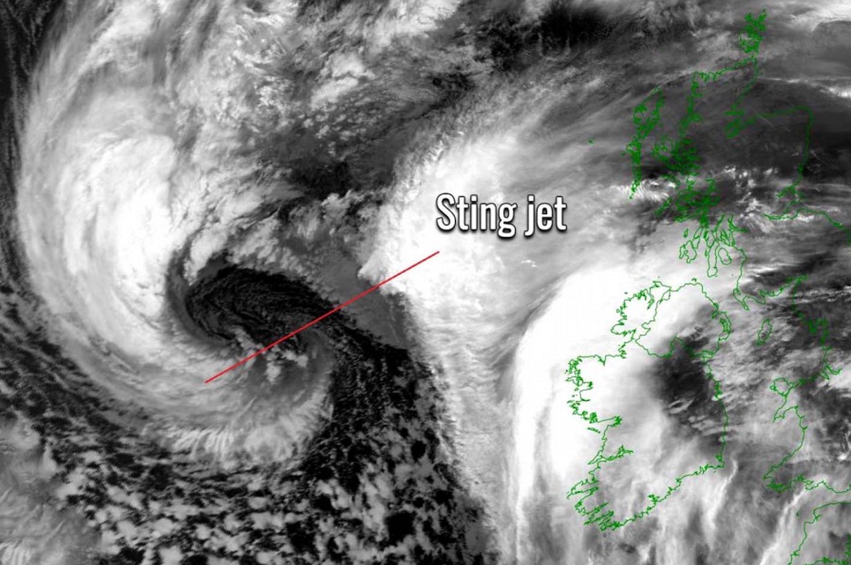
A system of such scale indeed produces violent winds and waves, with the winds being particularly violent in a small area that sometimes occurs. The main driving factor behind these winds is known as the sting jet wind maximum.
STING JET – A VIOLENT FORCE OF NATURE
The meteorological phenomenon known as a sting jet is usually blamed to produce violent (hurricane-force), and destructive winds. It is very often leading to peak wind gusts well above 150 km/h, sometimes those surpass the 200 km/h. It is a rather narrow zone of severe winds, originating from within the mid-tropospheric cloud head within the explosive cyclogenesis or a bomb cyclone.
A textbook extratropical cyclone is made of two frontal zones, the warm front, and the cold front. A strong flow of cold air mass develops into the cyclone ahead of the warm front. We call it a cold conveyor belt. Behind the main cold front, a much cooler and drier air mass, very often from the Arctic region, flows into the cyclone. Thus, forming the dry intrusion towards the core of a deepening cyclone, typically emerging from the southwest direction.
The cold conveyor belt brings cold and moist air towards the center of the extratropical low, together with precipitation as rain and snow. While the dry intrusion brings cool, but very dry air into the cyclone at the same time. So as the precipitation is falling from the cold conveyor belt into the dry air within the dry intrusion, those are quickly evaporating and further cooling the air mass with a process known as evaporative cooling.
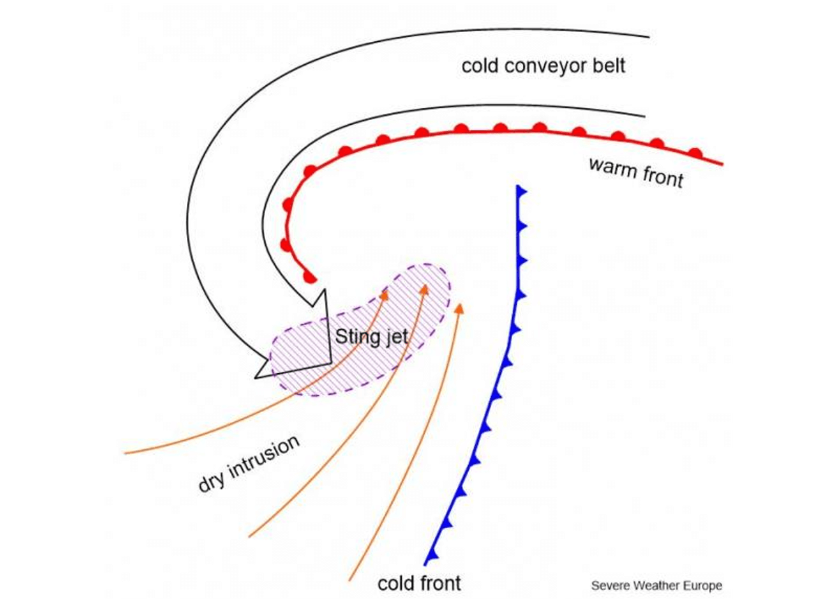
Finally, as the jet (wind flow) descends towards the surface, these winds are further intensifying as the air is drying out. The winds are literally grazing and evaporating the air on the nose of this descending jet, creating a clear path through the precipitation. But the evaporative cooling also leads to the air becoming much denser within the jet which causes the acceleration of the downward momentum flow towards the tip of the cloud head when it wraps around the cyclone dead center.
All these processes with the sting jet phenomenon are occurring at altitudes up to about 3-4 km and lead to extremely severe wind gusts, very often easily exceeding 90-100 mph (150-160 km/h) or evening stronger than 125 mph (200 km/h). A developed wind jet is fairly easily recognizable as the cloud, hooked like a scorpion’s tail. This gives the violent wind region its name the ‘sting jet’.

A sting jet normally affects a small region, compared to the size of the parent large bomb cyclone, and it usually lasts only for several hours. But it if reaches the land areas, destructive winds occur. This entire region of this cooled, accelerated air is narrow, forming a jet that is known as the sting jet.
We would expect a pretty typical satellite appearance of the banded cloud heads with any type of these bomb cyclones with sting jets. The cloud head is strongly curved into the cyclone, that is why it really looks like a scorpion’s tail and stinger alike shape. Also note, that these cloud bands terminate quite sharply due to the effect of evaporation in the dry air of the dry intrusion.
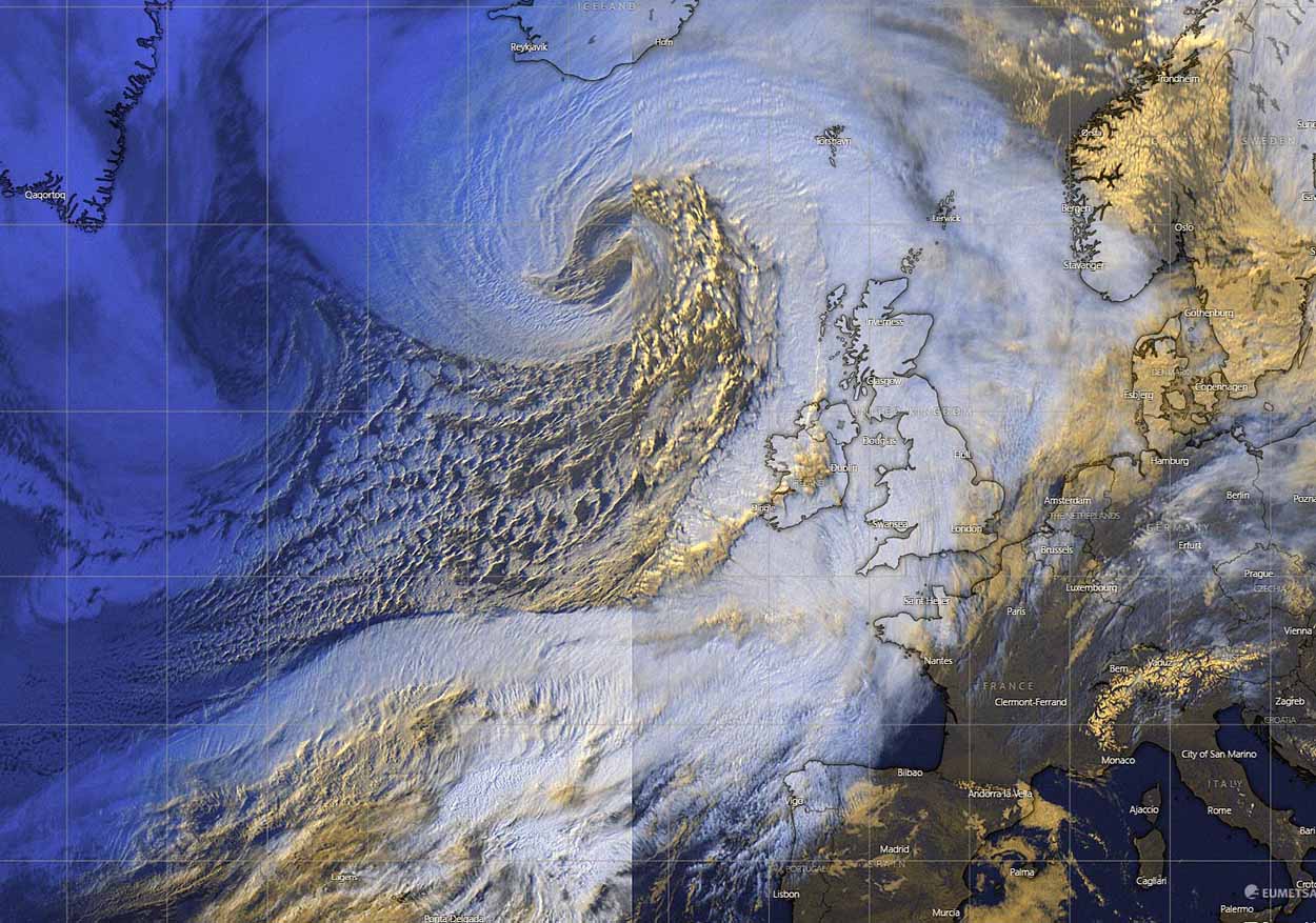
VIOLENT, HURRICANE-FORCE WINDS AND MASSIVE WAVES UP TO 18m TOWARDS ICELAND
The system with the violent wind’s maximum will remain far from the European mainland and will be limited to the areas around the center of the bomb cyclone. Particularly severe to hurricane-force winds will spread across a broad area over the far North Atlantic Ocean between Greenland and Iceland.
The majority of the winds will develop along the southern and southeastern coasts of Greenland and across much of Iceland as the system tracks north-northeast through Sunday night into Monday. At that time, the cyclone will mature its process and end the rapid intensification process, bottoming out the central pressure to around or even below 930 mbar to the southwest of Iceland.

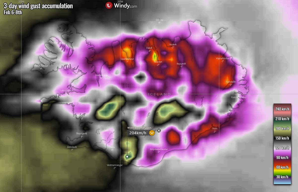
The accumulation of wind gusts (chart above) hints at how a large part of the North Atlantic will be affected by this storm. The peak wind gusts will likely well exceed the 220 km/h (130 mph) on the northern side of the low, grazing across southeastern Greenland.
This part of the low is often most dangerous when such storms occur as the pressure gradient between the center of the low against the very high pressure across the Greenland icy high plateau is extreme. It will be more than 80 mbar in this case.
A front-end of the low will also spread very powerful winds towards Iceland, with gusts from 150-200 km/h (90-125 mph). What is important to note is that the bomb cyclone will be so deep, that the pressure gradient will also be significant across the whole of Iceland.
Meaning that the peak gusts will be blasting from 120-150 km/h in many areas, being extremely violent over the exposed areas where the downslope flow will be enhanced by the slopy terrain. There, winds above 200 km/h (125 mph) are pretty much expected.
So the very tight pressure gradient from Sunday afternoon into Monday morning will be generating major waves as well, reaching incredible heights up to around 18 meters to the south of the low. Those waves will spread across a very large area, and gradually affect southwestern Iceland on Monday.
As the extratropical storm matures its stage by Monday morning, it moves slowly towards the northeast between Greenland and Iceland. This will help the push of the highest significant waves towards the western and southwestern parts of Iceland. The highest threat of the waves up to around 15 meters will be the Southern peninsula where the main Keflavik airport is situated, as well as the Vestmannaeyer islands.
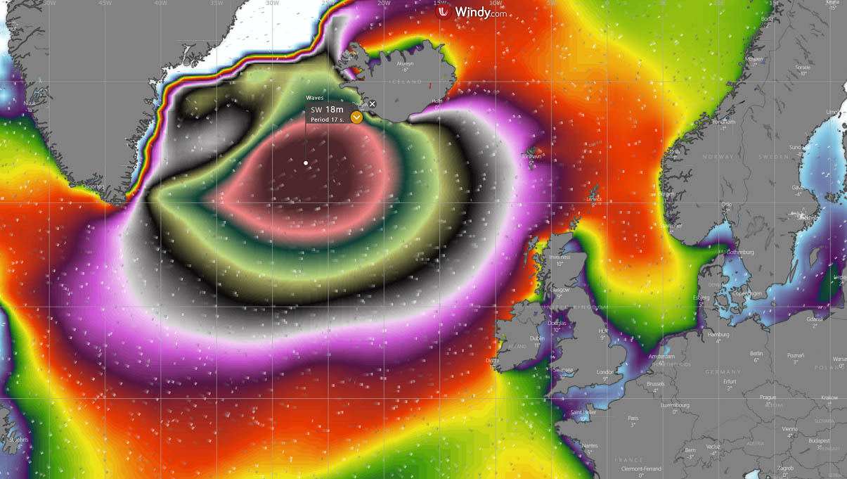
Despite the winds gradually decreasing at that time but spread across a much broader area, a large swell will reach the European mainland coasts as well. With time, major waves and swell will also spread towards western and northwestern Europe, reaching the Faroe Islands, Northern Ireland, and Scotland on Tuesday. The highest waves could reach up to around 12 meters (40 ft).
With so much moisture the system brings into the North Atlantic, significant snowfall and blizzards will also develop for southeastern Greenland and much of Iceland. Thus, leading to potentially more than half a meter of snow (2 feet), with local mountain ranges close to 1 meter where the orographic flow is enhanced.

The general west-southwesterly flow to the low of the low also spread towards northern Europe, with an impressive band of snow extending across the Faroe Islands towards western Norway as well. The mountains of southwestern Norway are again prone to another meter of fresh snow, adding an additional amount to already extreme snow depth this Winter Season 2021/22 there.
Some fresh snow is also forecast to develop across the northern UK, Scottish Highlands in particular, with about 20-40 cm possibly through Wednesday.
Images used in this article were provided by Windy, TropicalTidbits, and PivotalWeather.
SEE ALSO: