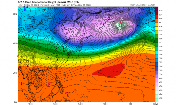
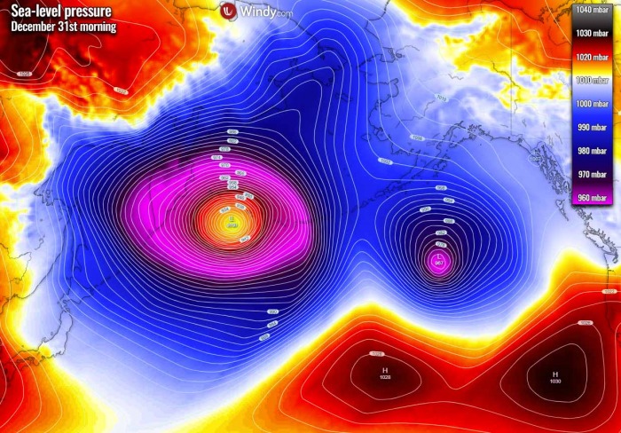
The North Pacific sees no rest this winter. And now, the weather has decided to challenge the all-time pressure record for the region. The combination of the deep Arctic cold over Siberia, the advection of a warm Pacific tropical air mass, and the extremely powerful 250 mph jet stream separating these two air masses is resulting in an *explosive* extratropical storm with its central pressure forecast to bottom out near 920 mbar and blast into the Aleutian Islands.
As we discussed in our previous article about the ongoing explosive extratropical storm south of the Aleutians today (Wednesday), the Northern Pacific has been extremely active this year and is brewing something more.
There were many intense mid-latitude cyclones (extratropical lows) lately and North Pacific is showing no signs of easing off anytime soon.
Thanks to the ongoing La Nina pattern, there is an above-average activity over the North Pacific with huge amounts of rain and snow for the Pacific Northwest of the United States and Canada. Actually, this is a typical La Nina pattern evolution.
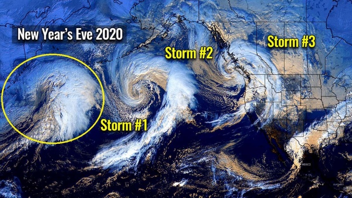
And to make all this even more interesting, there are now three extratropical storm systems simultaneously ongoing in the North Pacific.
This new storm we are featuring in this article has started near Japan on Tuesday and has been steadily strengthening since then. And since this Wednesday morning, it has entered an explosive intensification, arriving at the south of the Kamchatka Peninsula.
The system is heading straight for the Aleutian Islands and the Bering Sea for the last day of the year, right for New Year’s Eve 2020. It will graze across the westernmost islands of the Aleutians with extremely powerful life-threatening hurricane-force winds and major destructive waves.
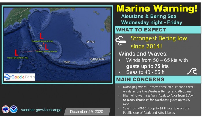
According to the National Weather Service in Alaska, this extratropical storm will be the strongest Bering Sea low since 2014 when the remnants of Super Typhoon Nuri blasted through.
We’re saying goodbye to 2020 with the strongest Bering low since Typhoon Nuri in 2014! Waters near the Aleutians can expect hurricane-force winds and seas between 40 & 50 ft! A High Wind Warning has been issued from Atka to Adak for wind gusts up to 85 mph Thursday morning.
There is very high forecast confidence that a deep and very powerful low-pressure system will move into the Western Bering Sea starting
Wednesday evening. Based on the various model guidance, the system will likely have a minimum central pressure of less than 925 mbar, which would be one of the deepest storms in the Bering Sea since Nuri.
This extratropical storm will bring a broad area of hurricane-force winds to most of the waters west of Unalaska and the Pribilof Islands beginning Wednesday evening through Friday.
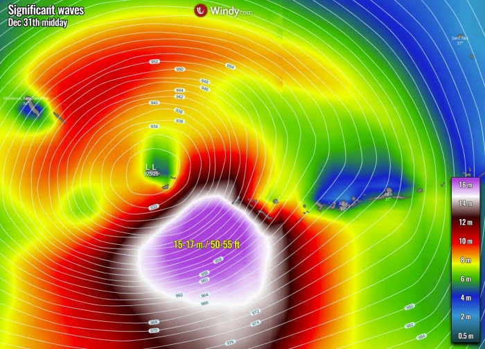
In addition to hurricane-strength winds, the monster storm is predicted to kick up significant wave heights, potentially with waves in excess of 50 feet to nearly 55 feet (17 meters) on the Pacific side of the Aleutians from Adak to Attu Island on Thursday. Those could be destructive for the coast.
BOMB CYCLONE TO ITS FINEST
The background leading to this storm’s evolution and its potential to challenge the all-time Alaska and Bering Sea pressure record, is an impressive, frigid cold with below -55 °C spread across parts of Siberia, Russia in these final days of 2020, rushing eastward towards Japan and the Northwest Pacific Ocean.
As this deep and extreme cold Arctic air mass interacts with a strong Pacific jet stream, the result is yet another violent extratropical storm.
And it will not be just another intense storm in line, but very likely it could become the most intense Earth’s storm of the year! Actually, the potential is there for a new record-holder storm for the area with the lowest atmospheric pressure ever recorded. For both Alaska (926 mbar) and the Bering Sea (924 mbar)!
This new storm is taking almost the same track as the last extratropical storm a few days ago. It will graze across the southwestern portions of the Aleutian Islands with extremely powerful winds and 50+ feet waves.
Its intensification rate will be so intense, that its central pressure fall will be more than double the threshold for a bomb cyclone*. Weather model guidance hints more than 60 mbar pressure drop within 24 hours period from Wednesday morning into Thursday morning.
*Bomb cyclone or a bombogenesis is a meteorological term that describes a mid-latitude cyclone (a so-called extratropical low or storm) that rapidly intensifies. Both with winds and indeed its central pressure.
The bombogenesis process occurs when an extratropical storm rapidly intensifies, dropping its central pressure at least 24 millibars over 24 hours period. A millibar measures atmospheric pressure. This can happen when a cold air mass collides with a warm air mass, such as air over warm ocean waters, and leads to an explosive strengthening of the storm.
The formation of this rapidly strengthening weather system is a process called bombogenesis, which creates what is known as a bomb cyclone.
STORM COULD CHALLENGE THE ALL-TIME RECORD
Forecast confidence is very good that the last storm of 2020 could be extremely dangerous and has the potential to become one of the strongest North Pacific, the Aleutians, and the Bering Sea extratropical storms on record.
The storm’s central pressure is forecast to bottom out at an exceptionally low pressure below 925 mbar. The all-time low pressure ever recorded in Alaska remains a 926 mbar record from at Dutch Harbor on October 25th, 1977, according to meteorologist dr. Jeff Masters.
This storm could definitely challenge the Bering Sea lowest pressure record of 924 mbar and Alaska’s 926 mbar record!
The last time such a violent extratropical storm hit the Aleutian Islands, Alaska, and the Bering Sea were the remnants of Super Typhoon Nuri and this storm now could challenge that. If model forecasts for the minimum central pressure verify, we could be seeing one of Earth’s strongest storms on record on Thursday, Dec 31st.
For your reference, only two storms in the 2020 Atlantic hurricane season had lower pressure readings that this storm’s pressure is forecast. Category 5 hurricane Iota had its minimum central pressure of 917 mbar while Hurricane Eta peaked as a Category 4 with 923 mbar. Both storms were moving across the Caribbean Sea in November.
And indeed this is absolutely not a good way to compare the strength of tropical and extratropical storms. Hurricanes are fueled by extremely warm sea temperatures, while the extreme temperature gradients (air mass coming from the Arctic region) in the northern latitudes fuel the extratropical storms over the North Pacific or far North Atlantic.
But just to give you an idea of how extremely low pressure can go in these systems, no matter if they are tropical or extratropical storms.
Now, let us dig into the most important details with the extratropical storm evolution on its way for the Aleutian Islands.
HOW WILL THE STORM ACTUALLY DEVELOP AND WHY?
According to weather expert Michiel Baatsen, assistant professor at Utrecht University, a very impressive and remarkably textbook case of explosive cyclogenesis was taking shape over the Northwest Pacific Ocean on Tuesday. The low was analyzed over Japan at 12z Tuesday (Dec 29th) with a central pressure of about 1008 mbar.
And its pressure drop is going to reach around or even below 925 on Thursday morning, so about 80 mbar over the roughly 36 hours when reaching the Aleutian Islands.
Baatsen explains the background process on the storm’s evolution:
How come such an intense cyclone can form in the current situation and how will it manage to keep deepening rapidly for over 2 days? The answer lies in the air masses clashing over the region and the dynamics overhead:
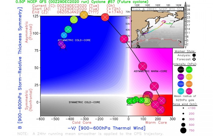
- Deep arctic air originating over Siberia (where some -50 °C temperatures were recorded recently) will meet tropical air advected from the Western Pacific warm pool (where the ocean surface is at around 30 °C year-round). The gradient taking shape in between is reflected well by the asymmetry parameter getting literally off the chart in cyclone phase space diagrams.
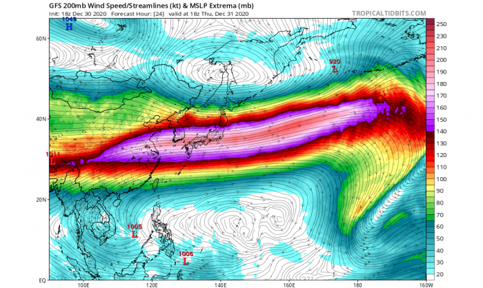
- An exceptionally powerful jet stream in the upper troposphere (100-110 m/s at 200-300 hPa, which is 10-12 km above the surface) separating the two air masses. The geography of Central/Eastern Asia favors the merging of the otherwise mostly separated polar and subtropical jet streams (as seen in the vertical cross-section).
- The cyclone forms in a region of very favorable upper-level divergence, underneath a combined left exit and right entrance regime of two jet streams. It then interacts with the strengthening upstream jet streak and moves in sync with its left exit region, meaning that the system keeps deepening until it slows down and the interaction becomes unfavorable.
- The transition between upper-level configuration also means that the system will likely acquire a somewhat hybrid structure; starting off following the Shapiro-Keyser (i.e. seclusion) conceptual model but in time moving more towards that of the Norwegian School (i.e. occlusion).
*VERY* RAPID INTENSIFICATION UNDERWAY
The intensification of this extratropical North Pacific storm is at an extreme rate this Wednesday. Its strengthening has begun on Tuesday while emerging near Japan with the very cold Arctic air mass blasting into the Northwest Pacific from the Russian Siberia.
The cyclone has already deepened to 960 mbar as of 18 UTC Wednesday, with a deeping pressure of around 10-15 mbar per 6 hours period. The system is already become an impressive monster storm and is not even close to its peak intensity.
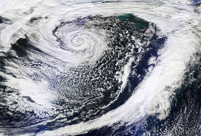
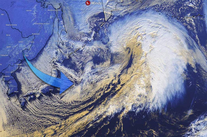
The wide visible satellite channel view above reveals a very cold air mass spreading over Japan, with typical convective cloud rolls spreading snow squalls towards Japan, known as sea-effect snowfall. This will generate a massive snowpack over parts of Japan, locally close to 1 meter (100 cm) of fresh snow!
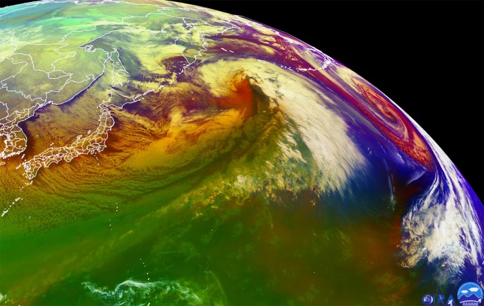
There is also a textbook appearance of an explosively strengthening extratropical storm and a well-defined dry intrusion visible, being pushed into the storm from the southwest.
The above image is another satellite view, provided by CIRA/RAMMB NOAA. It shows a perfect example of the dry conveyor belt pushing into the storm’s core. The evolution of both storms is pretty remarkable. Notice also another spectacular storm on the far east, that’s the storm south of the Aleutians today.
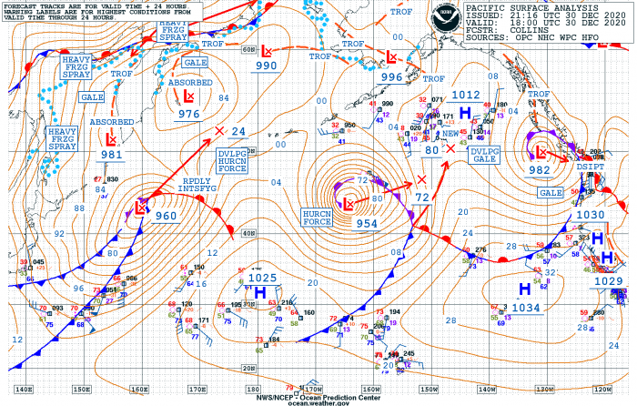
Further down is the surface data analysis for the estimated mean sea-level pressure by the NOAA Ocean Prediction Center (OPC).
The surface pressure analysis shows this extratropical storm evolution from its birth near Japan on Tuesday, entering the explosive intensification while gradually growing its size and rapidly lowering its central pressure through Wednesday:
- 960 mbar at 18 UTC, Dec 30th
- 972 mbar at 12 UTC, Dec 30th
- 986 mbar at 06 UTC, Dec 30th
- 996 mbar at 00 UTC, Dec 30th
- 1001 mbar at 18 UTC, Dec 29th
- 1008 mbar at 12 UTC, Dec 29th
As we can see from the pressure analysis above, the central pressure in this extratropical storm had an impressive 26 mbar pressure fall over the last 12-hour period and 41 mbar pressure change over the last 24 hours, between Tuesday 18 UTC and Wednesday 18 UTC.
This is nearly double the threshold for bombogenesis, while the storm is now intensifying at an even faster rate. It is expected to deepen for another 35-40 mbar over the next 24 hours!
The system continues moving towards the northeast of Japan and to the south of the Kamchatka peninsula, directly for the impact on the Aleutian Islands on Thursday.
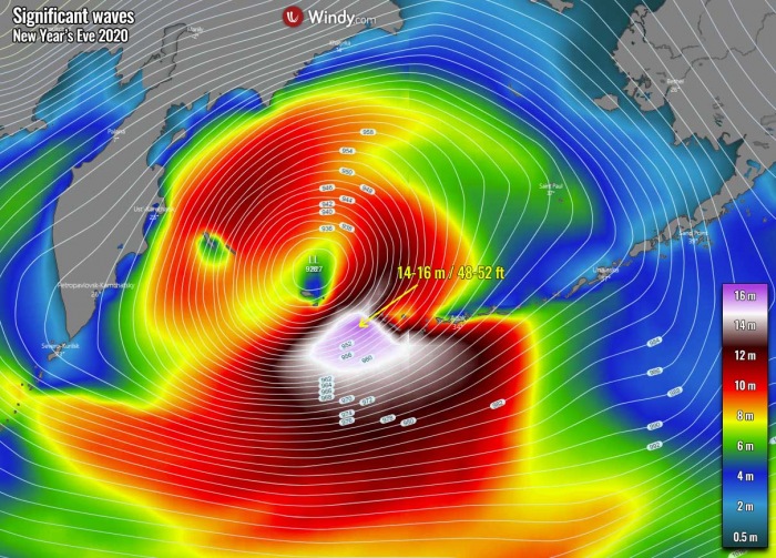
Heading straight for the Aleutian Islands and the Bering Sea and is expected to graze across them for New Year’s Eve 2020. Its center will pass across the westernmost islands of the Aleutians with extremely powerful winds and major near 50-55 feet waves.
And if the weather model guidance verifies with the pressure to fall below 925 mbar on Thursday, the system is definitely challenging the all-time record for the North Pacific region.
TWIN STORMS OVER THE NORTH PACIFIC
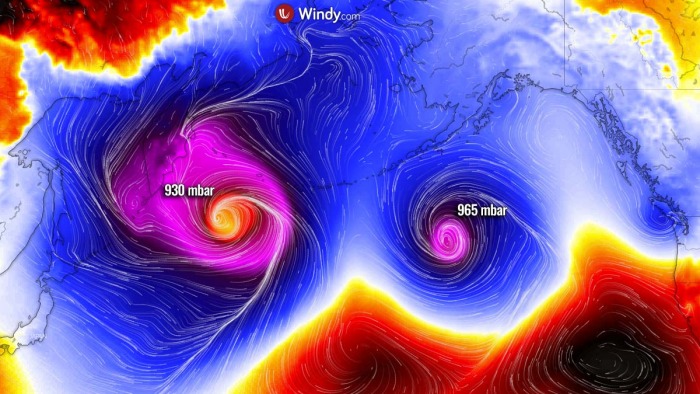
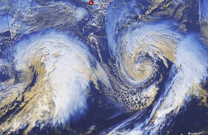
While the storm is moving towards the Aleutian Islands, the second storm to its right is still very intense. And both are creating an impressive twin-cyclone tandem over the North Pacific. The eastern storm (right), however, is weakening while the main featured storm is explosively intensifying (left).
The tandem of storms are separate systems, so not interacting with each other. But are both impressive on the satellite view. An obvious difference in their strength is quite easy to judge, as the new storm (left) looks like the mother of all storms.
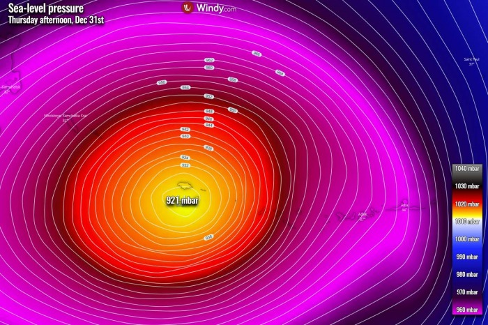
Attached is the GFS model simulation for the central pressure and we can see it hints at 919 mbar! And also the ECMWF model is not far behind, so we can confidently expect the low will reached well below 925 mbar at its peak.
It is forecast to pass across the westernmost Aleutian Islands right for New Year’s Eve 2020. Maintaining its central pressure around 925 mbar or even lower. This will be very near or even lower than existing Alaska’s historic record of 926 mbar from at Dutch Harbor on October 25th, 1977.
HURRICANE-FORCE WINDS AND 50+ FEET WAVES FOR ALEUTIANS
The main impact of this extratropical storm will be the rough power of destructive winds, and indeed the significant wave heights.
Violent winds are developing across the southern portions of the storm, with the forming sting jet wind maximum. These winds are very likely to reach up to near 200 km/h (125 mph) while the low will be nearing the Aleutian Islands by Thursday afternoon and evening hours.
Although the strongest winds might vanish until the storm reaches the Aleutians, its huge wind swath will blast across the western half of the Aleutian archipelago. The peak gusts could reach 120-150 km/h, generating major waves with significant height above 15 meters (50 feet).
The highest waves will reach up to 17 meters (55 feet) and will be located to the immediate southeast of the storm’s center while it passes across the Aleutians. The blast to the islands will be extremely dangerous and life-threatening. And could also be destructive!
Storm then continues into the southern Bering Sea, remaining extremely intense and keep pushing major near 50 feet (15 meters) waves into the Aleutians. Huge waves will also generate across a large part of the Bering Sea, thanks to the size of this monster storm.
And this will definitely be the New Year’s Eve to remember. If the system does challenge the all-time Alaska (or Bering sea) records, it will be known soon as it passes, as pressure data are measured on the weather stations by the National Weather Service in realtime.
The existing lowest pressure record for the North Pacific by any extratropical storm since records began is held at 924 mbar, recorded on Nov 8th, 2014 over the Bering Sea.
Stay tuned!
Don’t miss:
