This weekend, a significant Arctic Cold Outbreak is heading for eastern, central, and southeastern Europe. The strongest cold of the season will blast far south, introducing a powerful winter storm across the Balkan peninsula, dumping huge amounts of snow from Romania to Ukraine. Weather models agree that a much colder period is forecast to extend through the end of November.
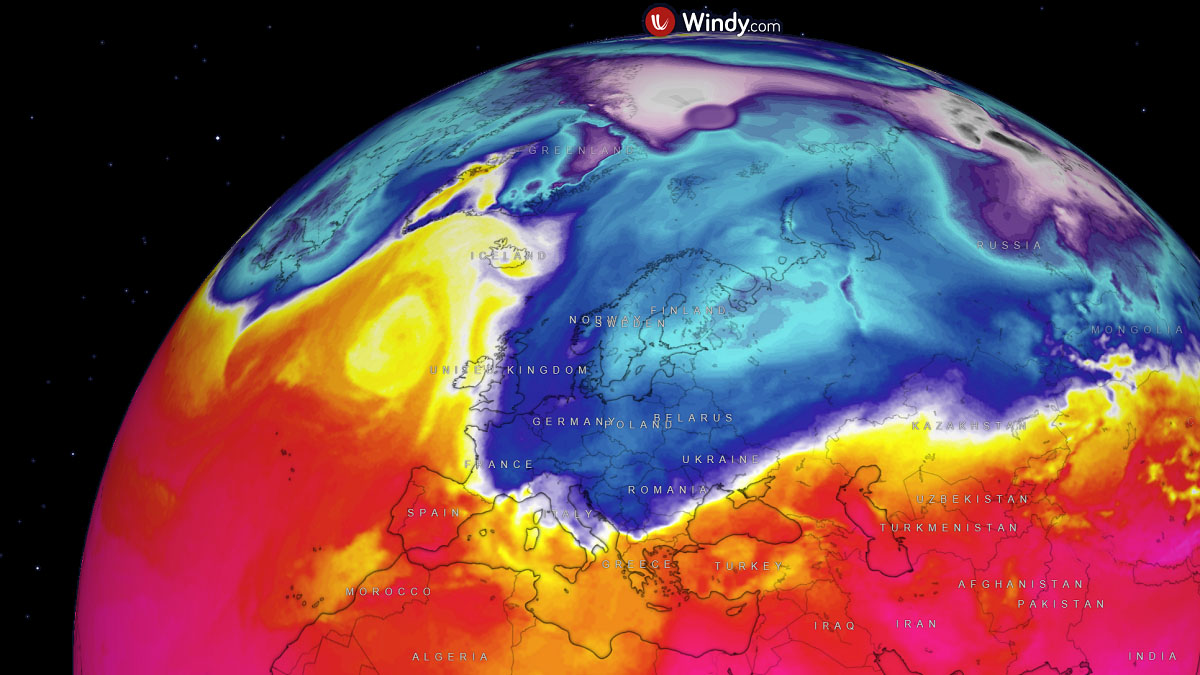
After unusually warm weather through the last weeks, a significant change in weather pattern is underway. A textbook dipole pattern is sharpening across Europe and the North Atlantic, with a strong blocking High on the west and a deep trough with cold on the east.
This pattern is forecast to introduce a major Arctic Cold Outbreak towards eastern and central Europe through Saturday and Sunday, expanding further south across the Balkan peninsula on Sunday and early next week.
With a lot colder weather coming up from the Arctic, clashing with much warmer across the Mediterranean and the Black Sea region, a powerful winter storm will take place over Greece. It will then rapidly strengthen into a major blizzard event in Bulgaria, Romania, Moldova, and Ukraine late Saturday into Sunday.
A swath of deep fresh snow is forecast to cover areas from Sofia across Bucharest towards Odesa and Kyev, Ukraine. With local snowfall accumulations up to around 50 cm in about 36-48 hours of intense snowfall, combined with strong to severe winds around the core of the winter storm.
In the wake of the winter storm, a large pool of much colder than normal air mass will overspread across central Europe, with a lot of snow forecast for the northern Alps due to persistent moisture advection with north-northwesterly winds.
Elsewhere, snow amounts will not reach significant amounts, as the first Cold Blast acts more as a fast-moving frontal system with a lack of moisture influx until the Arctic front meets warmer air mass closer to the Eastern Mediterranean on Saturday. More chances for snow follow next week.
Let’s dig into the details of the pattern evolution, which will flip the weather picture over Europe into a wintry mode.
Major Dipole Weather Pattern Develops across North Atlantic and Europe
The general weather pattern over the European continent is already changing as we are ending the working week, with the strengthening of the High-pressure system over the North Atlantic and a large upper trough deepening across the Baltic region.
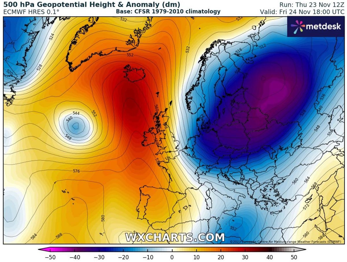
The contrast between the blocking High on the west and deep Low on the east will be significant, resulting in a strong meridional (northerly) jet stream in between. This is a textbook scenario for an intense cold outbreak from the Arctic region into much of Europe.
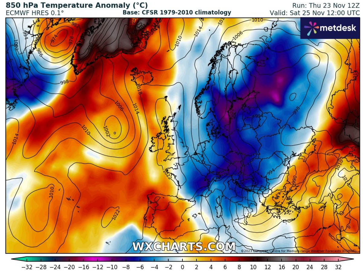
The progress of a much colder air mass than recently starts on Friday, intensifying through the weekend as the deep low on the east matures. Around 8-12 °C colder than normal temperatures will spread across eastern and central Europe on Saturday.
While temperatures will stay near-normal on the west, the Arctic cold pool will strengthen across Eastern Europe, especially the Balkan peninsula, through Sunday and Monday. The Arctic front will form a secondary low over Greece and the Ionian Sea on Saturday, leading to a winter storm. We will talk about it in detail a bit further down.
So, the cold over the weekend will bring significantly lower temperatures than recently experienced, even much below normal for the end of November.
Sunday and Monday will bring a pretty cold morning across east-central Europe and the Balkan peninsula.
Arctic Blast Develops A Powerful Winter Storm with Intense Snow Blizzard for Southern Balkans and Ukraine
With the progress of the Arctic front associated with the deep trough aloft, an even colder air mass is forecast to develop into the Balkan peninsula. The core of the upper low will dig south over Romania and the Black Sea region on Sunday.

A significantly cold air mass of this scale pushing so far south in November is unusual, clashing with warmer air fueled by still well-above-normal temperatures of the Mediterranean, Aegean, and Black Seas. This will lead to the development of a secondary frontal system along the Arctic front over the Ionian Sea and Greece.
A winter storm will begin strengthening over the southern Balkan countries, including Albania, North Macedonia, Greece, and Bulgaria, on Saturday, with heavy rains on the front end and heavy snow on the wake side of the low. The deepening low will also drag the much colder air mass closer to the surface of the Balkans.
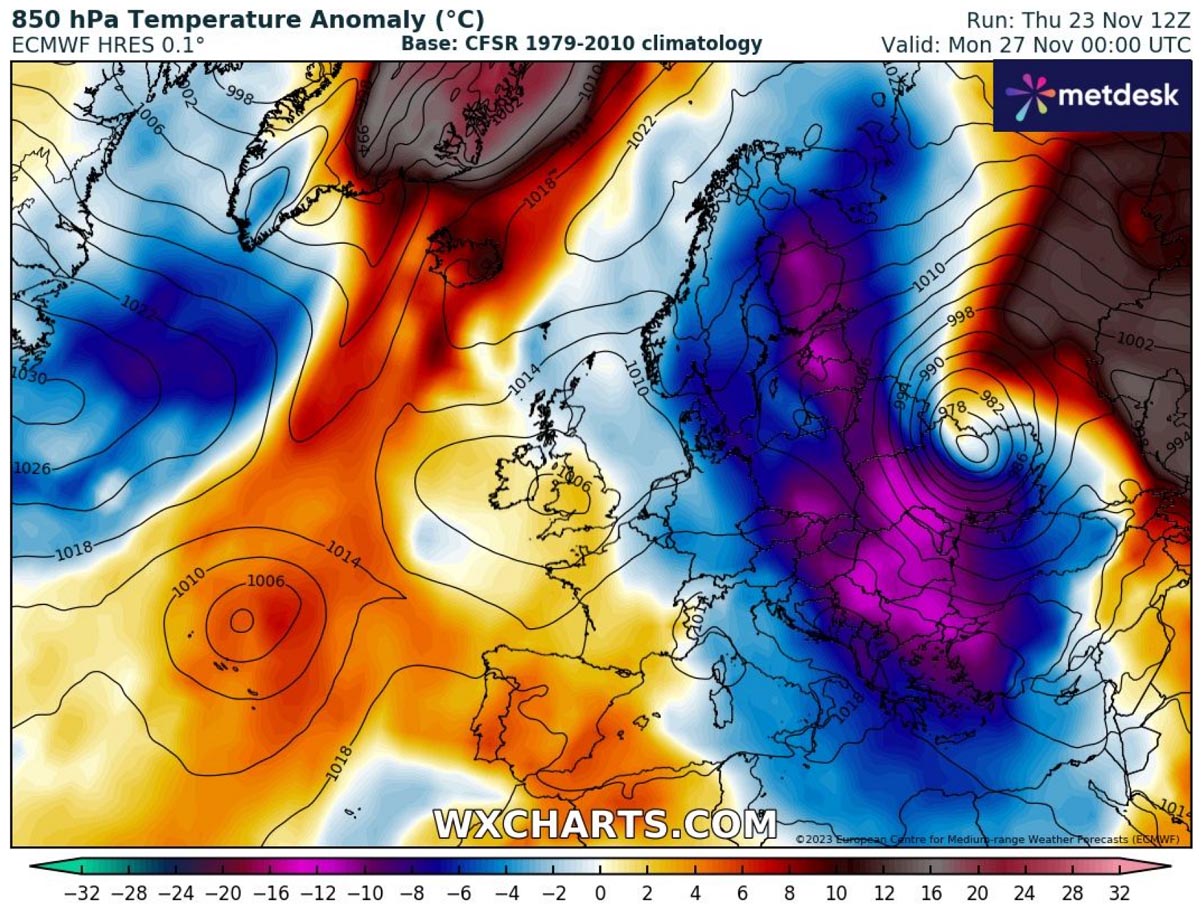
From the temperature anomaly chart above, we can see how well the corridor from the Arctic towards the Black Sea region is established, with a lot of cold air present and maintained over the weekend into next week. The cold is the most intense in the wake of the winter storm, as strong northerlies will follow.
The snow will become heavy late Saturday into the night, with surface low further deepening below 980 mbar, with the most intense snowfall for Bulgaria. Gradually spreading northeast as the low tracks across the western Black Sea and enter rapid intensification by early Sunday morning.
Central pressure is forecast to reach the low 960s, dropping more than 20 mbar in less than 24 hours between Greece and Moldova/southern Ukraine. This will introduce intense blizzard conditions for southeastern Romania, most of Moldova, and south Ukraine.

A combination of heavy snow and strong to locally severe winds will bring whiteout conditions and impassable roads; visibility will drop to near zero. Blowing snow will build high drifts. And combined with freezing cold and very low wind chills.
This winter storm has a large swath of thick snow accumulation forecast. It extends from southern Bosnia to North Macedonia, Bulgaria, southern Romania, and Moldova into the eastern half of Ukraine.
As we see, the highest snow accumulations are forecasted where the most intense snowfall will be triggered on the northern side of the intensifying core of the winter storm. About 30-50 cm of fresh snow is likely along this swath.

Even higher accumulations are possible in the higher terrain of southern Balkan states, where orographic snowfall will be the most intense and persistent, thanks to strong winds with this Arctic Blast.
Arctic Cold Pool Likely to Extend into Next Week, With New Winter Storm for West-Central Europe
The weather model consensus following the final week of November seems to agree that the Arctic Cold will maintain and even intensify across central Europe by mid-next week, as another push will follow from the north.
The cold could also extend westward for a few days, as an upper low will dominate most of the European continent next week.

A new winter storm will likely develop over Benelux and travel towards the Alpine region from Monday night into Tuesday. So this second wave also hints there will be more snow developing, blanketing parts of west-central Europe and the Balkan peninsula again.
With cold spread also towards western Europe, snow is quite likely to follow with the new system. Chances are fresh snow will develop over eastern France, Benelux, and Germany on Monday night, following further east-southeast over the Alps towards the Balkans on Tuesday.

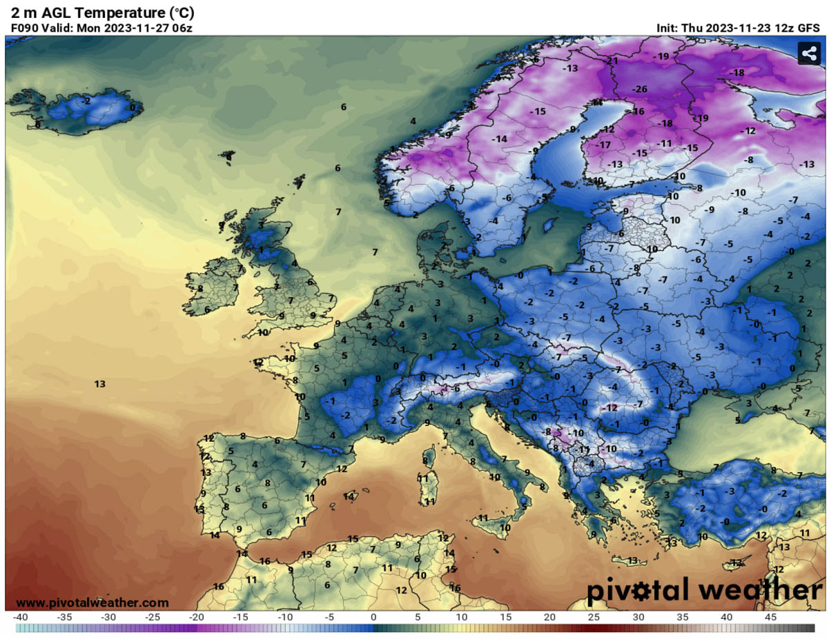
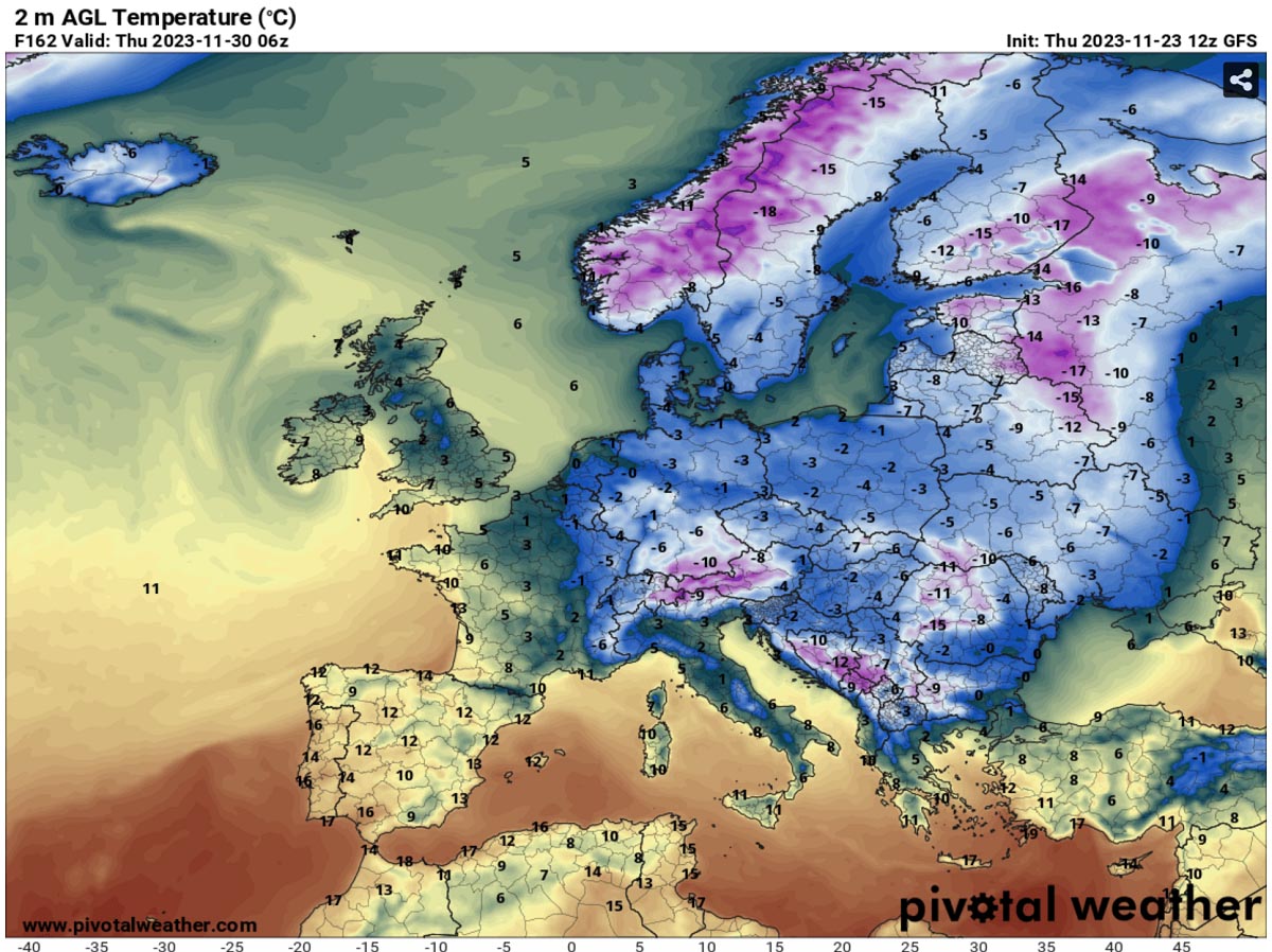
The 2m temperature chart below hints that mornings from Wednesday and Thursday will be pretty cold for many; locally, even below -10 °C will be possible. Especially where snow will accumulate on Tuesday.
However, the most significant cold will remain over Scandinavia and the Baltic region. With temperatures back to -20 °C or lower. Similar to those experiences early this week.
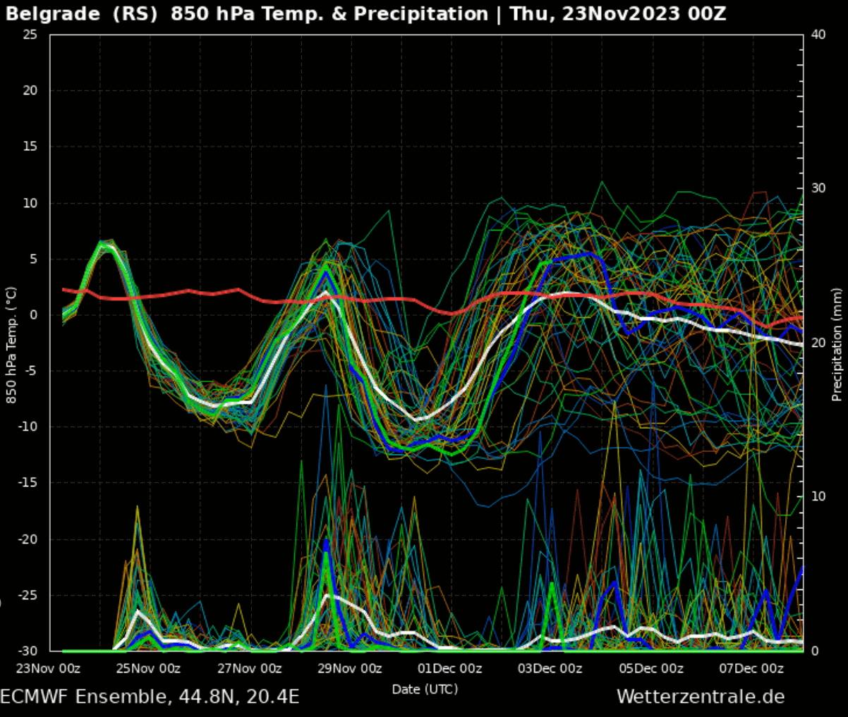
The secondary push from the Arctic is well seen on the following GFS Meteogram for Belgrade, Serbia, located in the central Balkans.
The first Arctic front is clearly seen over the weekend (25-27th November), followed by a temporal warm-up but an immediate cooling off again as the cold pool restrengthens mid-next week (after the 29th November).
This period of much colder weather than normal will significantly drop the monthly average November temperature for parts of Europe.
Wxcharts, Pivotalweather, and Windy provided images used in this article.
See also: