The final round of Winter models is out, and they all start to show a similar pattern. A blocking system is forecast to develop over Canada, creating a low-pressure area from the North Pacific across the United States into the North Atlantic. From there, the influence will also expand into Europe.
When dealing with seasonal forecasting, there is one very important thing to keep in mind. The forecast only shows the monthly average of the weather.
Inside that long-term average, many strong weather events can hide, as you will see in the very begging of this article and also this upcoming Winter 2023/2024.
WINTER COMES EARLY
Before we go into the final winter forecasts, we have to mention the upcoming weather patterns right on the doorstep of winter. Meteorological winter begins on December 1st and covers three months, ending on the last day of February in the Northern Hemisphere. It is different than the astronomical winter.
This period was chosen because December, January, and February are the three coldest months in the Northern Hemisphere. The official winter stats and records are also measured in this period.
So, looking at the first days of the meteorological winter below, we can see that winter comes early this year across southeastern Canada and the eastern United States. The first cold wave will start this weekend, with a stronger one coming next week, also bringing snowfall.
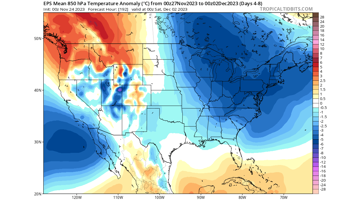
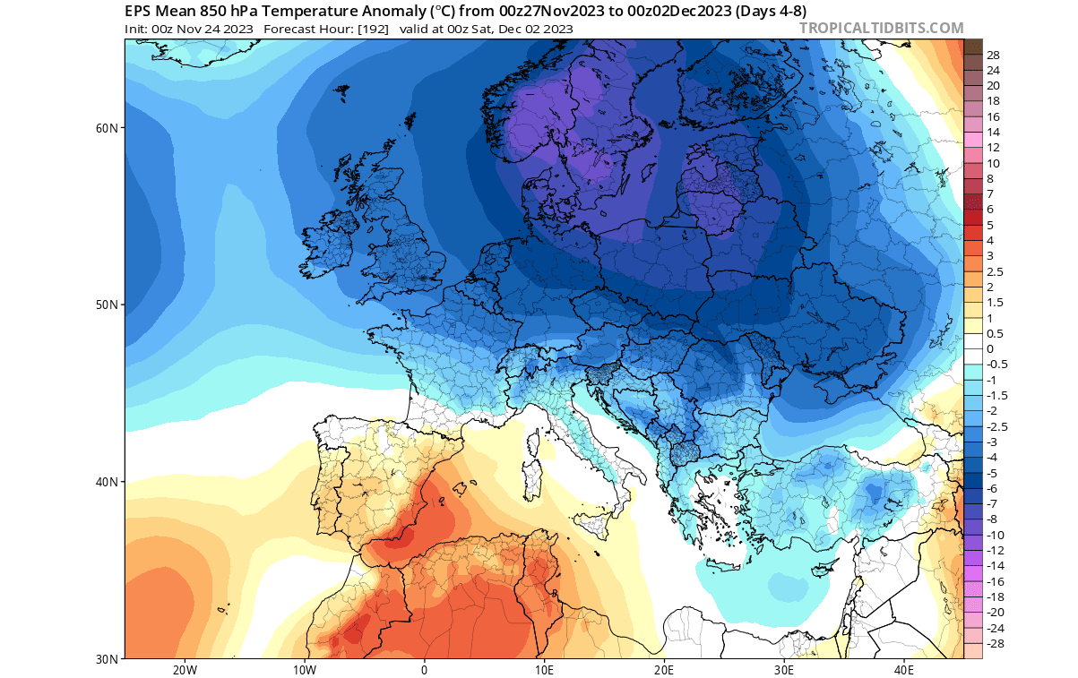
It is exactly the same over Europe, where the cold air has already started to descend and will last at least the first days of December. But what force can cause a winter pattern to appear on both sides of the hemisphere at the same time?
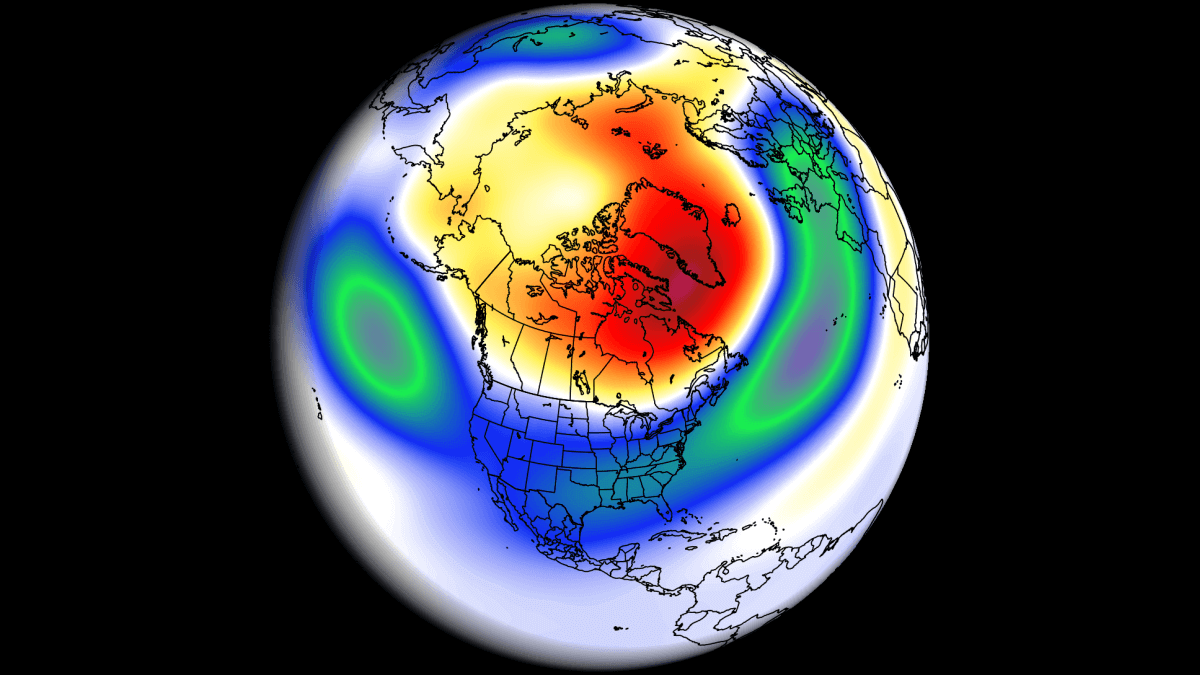
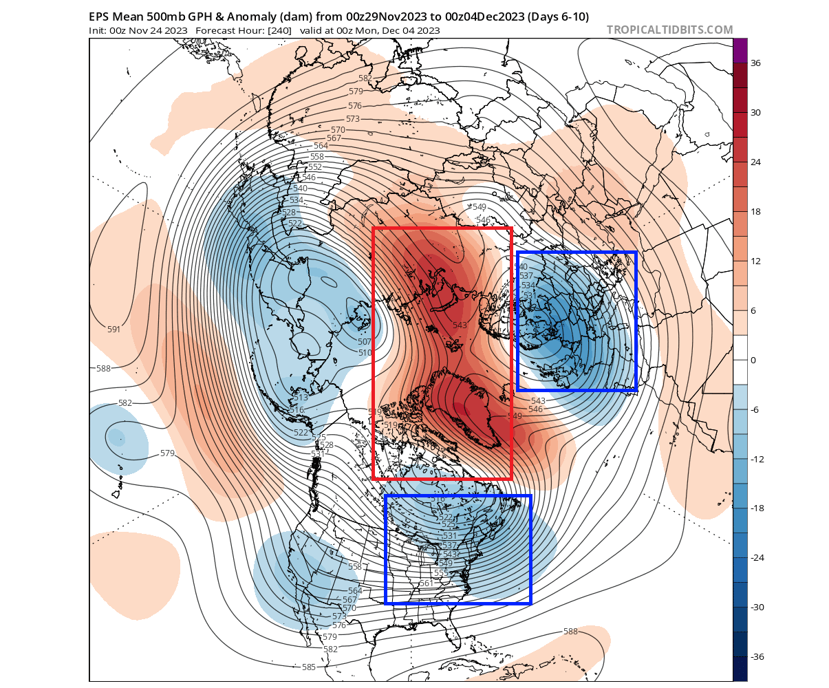
The answer is high-latitude blocking. As you can see below, a large area of strong pressure anomalies will develop over the northern regions, pushing out the cold air out of the north. Blue areas are the low-pressure anomalies, which are driving the cold air from the north down into the United States and Europe.
The reason we showed you this, is because this is the best example of why a 3-month average forecast cannot show us everything. Even when the winter forecast is all red in anomalies, you can still get these sharp cold events in between when the pressure systems go for a dance.
WINTER 2023/2024 FINAL FORECAST
The format of this forecast will be a bit different than what we usually do for a Winter outlook. In this article, we will first look at the global long-range models and their forecast for Winter 2023/2024 from the latest available data.
Then, we will also look at some statistical and historical weather patterns that are likely to emerge this Winter. The main story of this Winter is the El Niño event in the Pacific Ocean.
In this final forecast, we focus on the two seasonal models: the ECMWF and the UKMO. Graphics are open-sourced from the Copernicus Climate project.
All these forecasts show an averaged picture over three meteorological winter months (December-January-February) and show the general prevailing weather patterns.
Even if the models were 100% accurate in their forecast, it does not mean such weather conditions would last for three months straight. It only suggests how the weather patterns might look most of the time over the season.
ECMWF WINTER FORECAST
The ECMWF model is often referred to as the most reliable model. But no long-range/seasonal forecast is ever really “reliable”. That is because we are only looking at trends and how the weather patterns might evolve on a large scale over a longer period of time.
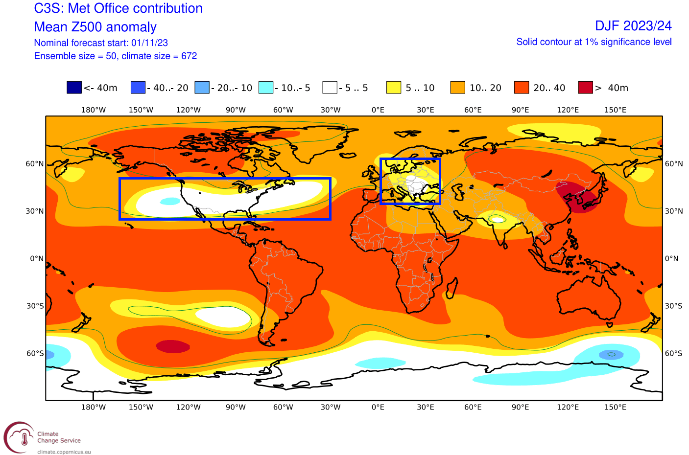
The winter pressure pattern forecast from ECMWF below shows an underlying El Niño weather pattern. A high-pressure zone over Canada and Greenland and a belt of low-pressure anomalies spanning from the North Pacific, the United States, and the North Atlantic.
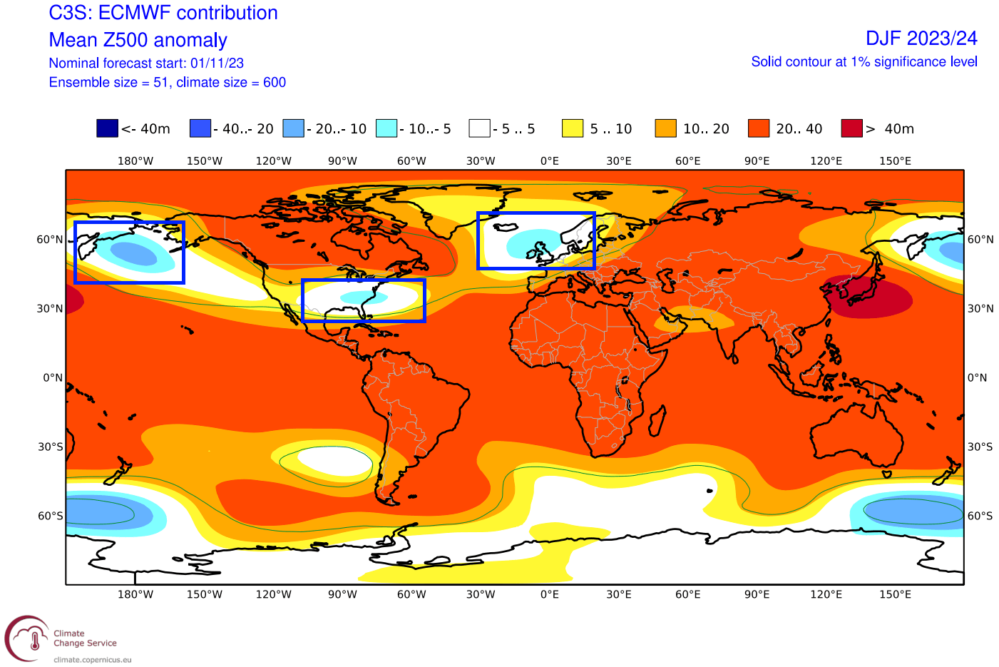
The two interesting anomalies are the low-pressure zone over the United States and over northwestern Europe.
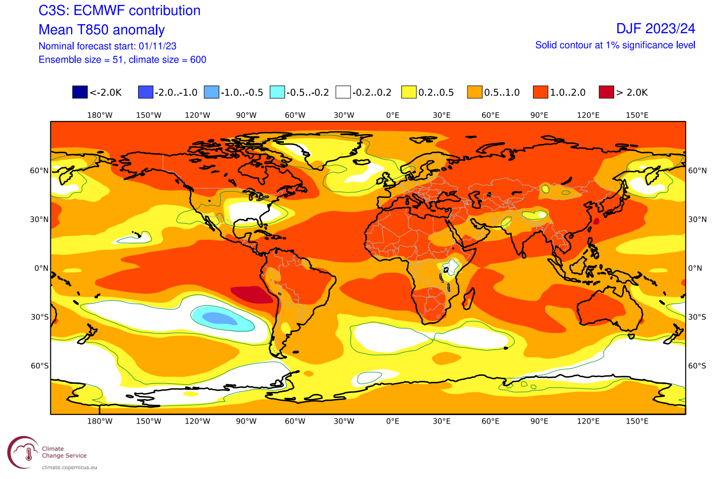
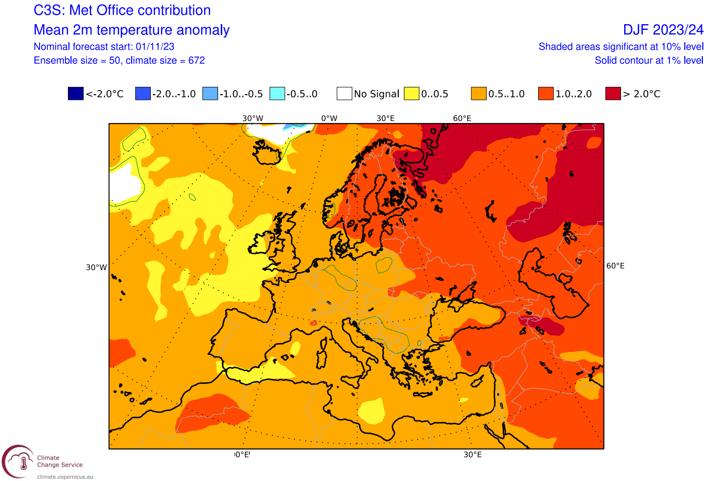
Focusing on the global airmass temperature below, you can see the eastern United States standing out with a neutral temperature zone and the North Atlantic/northwestern Europe area. Both are linked to the low-pressure zones.
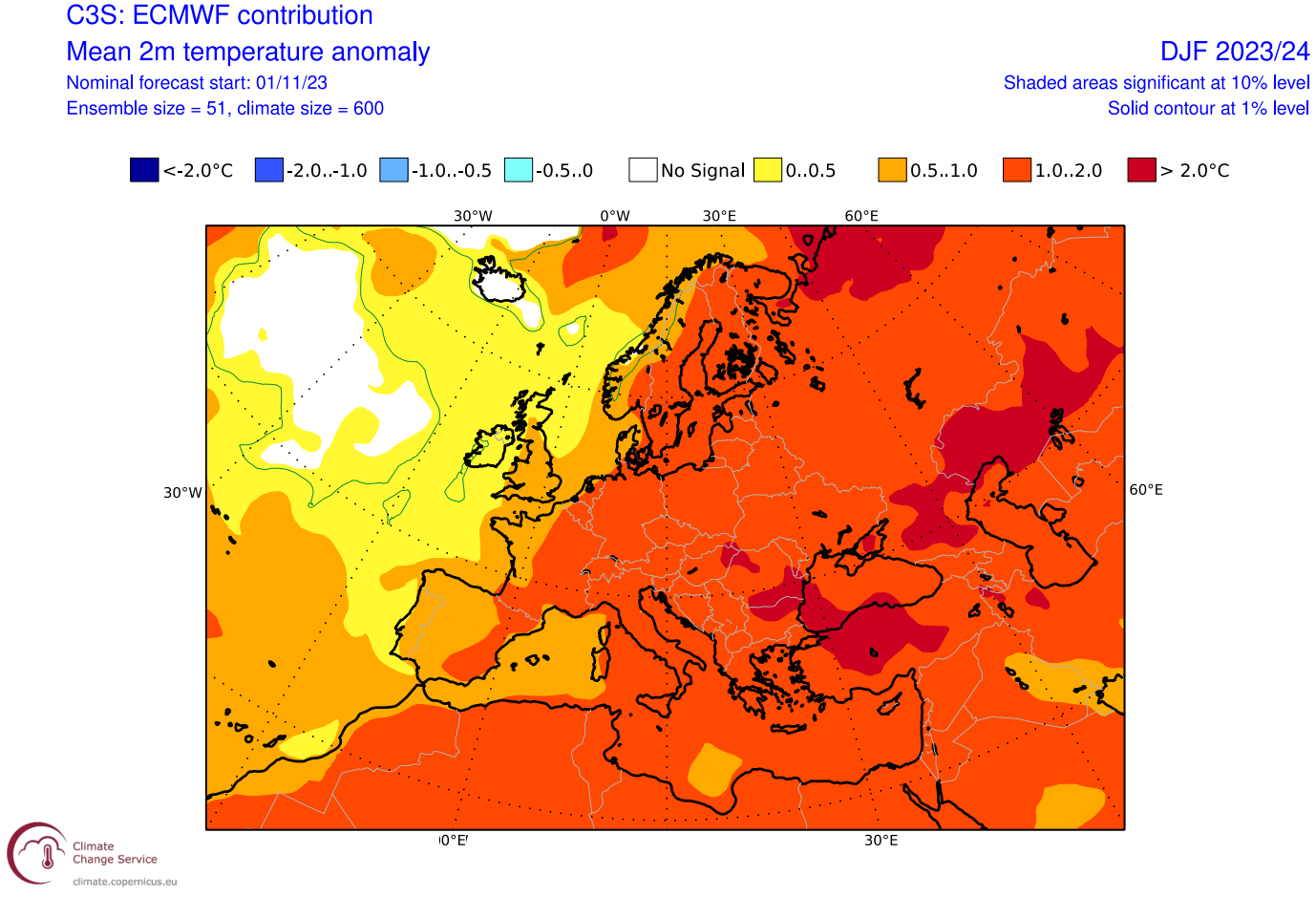
Looking at the surface temperature now, notice the surface temperatures are warmer than normal across all of Europe. This indicates a strong westerly to southerly flow in Winter. But, even in the warmest winters, there are still individual pattern breaks that can create an occasional cold air drop from the north.
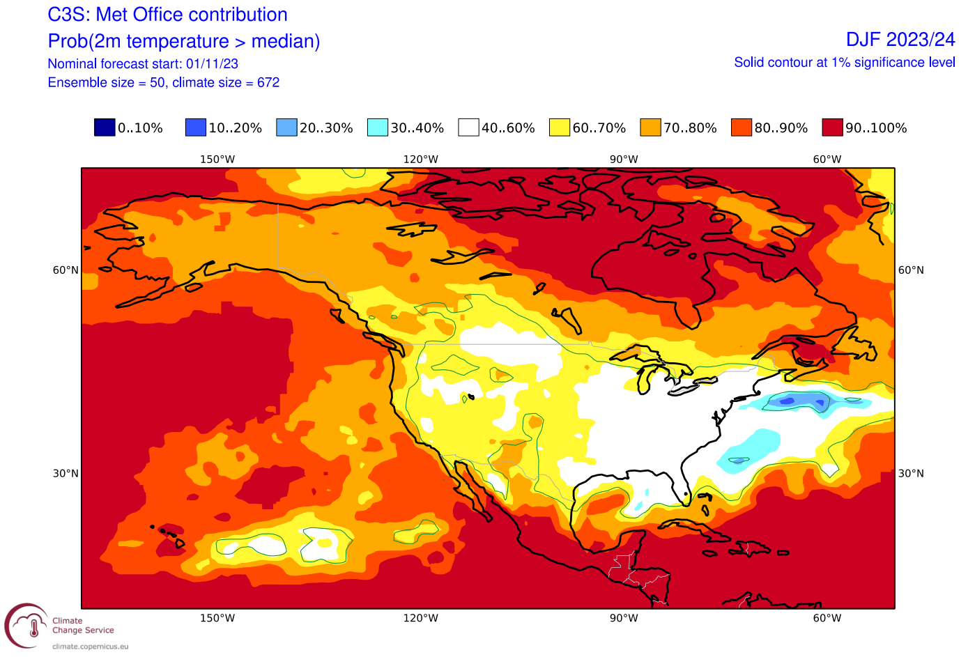
Over North America, the ECMWF forecast shows above-average temperatures over most of Canada. Warmer than normal temperatures are also forecast over the northwestern and northern United States. But most of the central and eastern United States is under the before-mentioned neutral zone. This basically means that in this region, there is a higher chance of seeing colder-than-normal events compared to other regions.
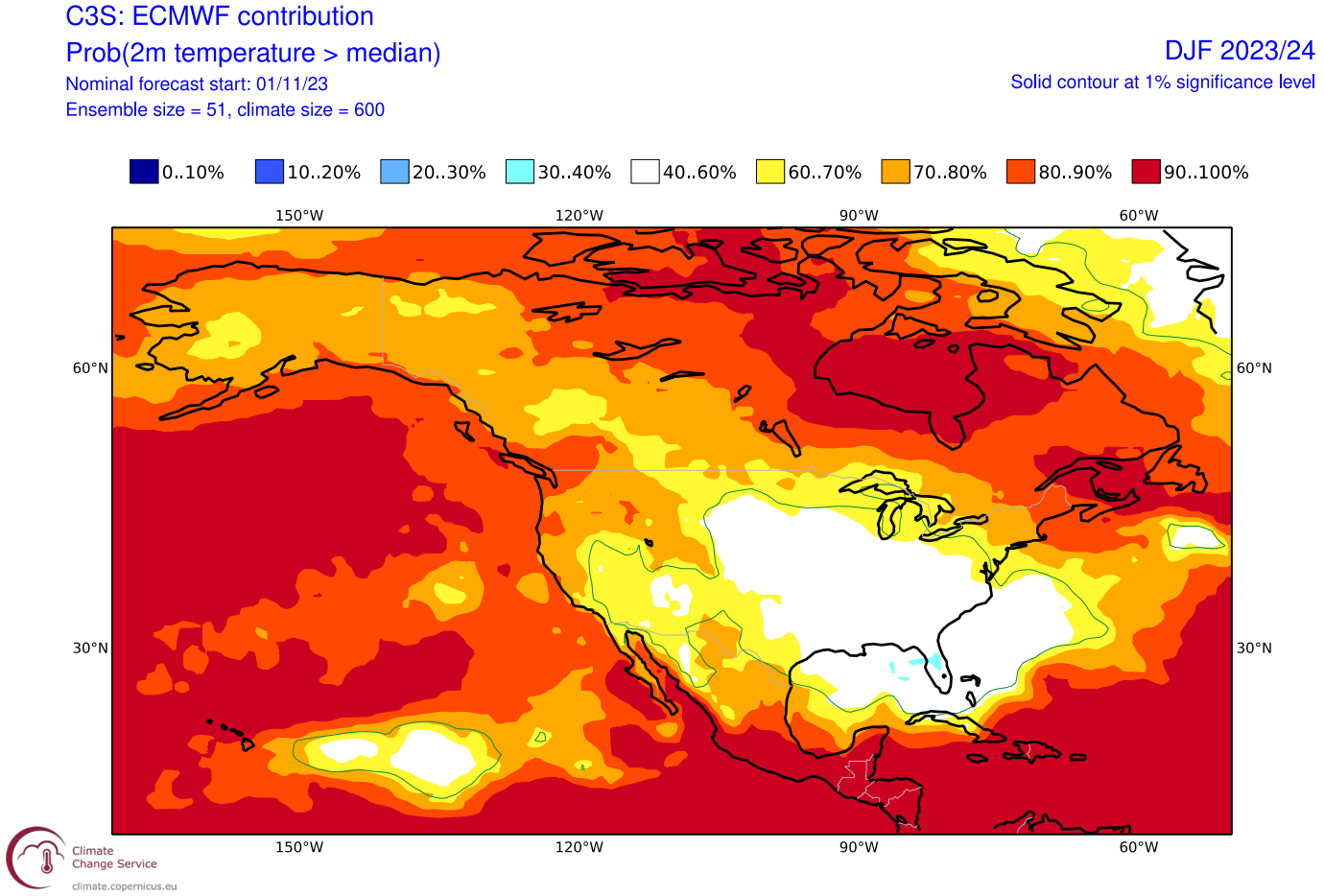
This temperature anomaly is expected for an El Niño winter in the southern and partially eastern United States due to the amplified subtropical jet stream and more low-pressure systems passing the region. But this anomaly does seem more than just some typical El Niño response and reflects a broader circulation pattern.
That neutral area of the central and eastern United States is more likely to see more winter storms and colder air compared to some other parts of the country. But overall, the warm periods in between are strong enough to make it look like a normal Winter temperature-wise when we average all 3 months in the forecast.
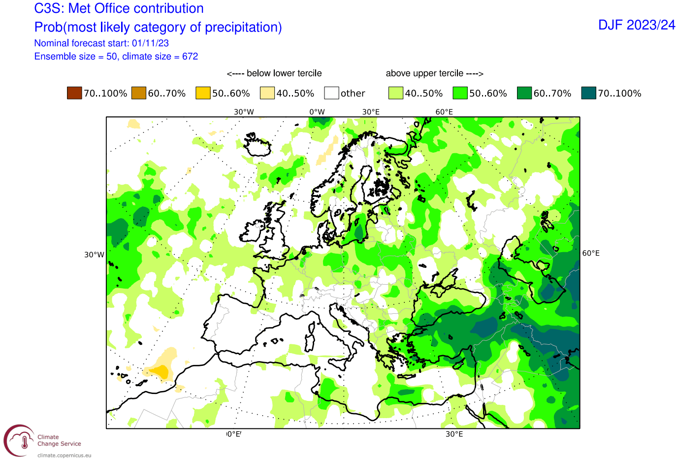
Going over to the precipitation, we can see above-average precipitation forecast for most of Europe. This increases the snowfall potential mostly over the higher elevations, as it is driven by the moist westerly and southwesterly winds.
The precipitation anomaly forecast for North America shows an expected El Niño-type pattern over Canada and the United States. You can see drier conditions over the Pacific Northwest and wet in the southern and eastern United States and across the central plains.
The strong subtropical jet stream of El Niño brings increased moisture and precipitation across the southern and eastern parts of the United States and the plains. This also increases the snowfall potential across these regions, provided there is enough cold air available.
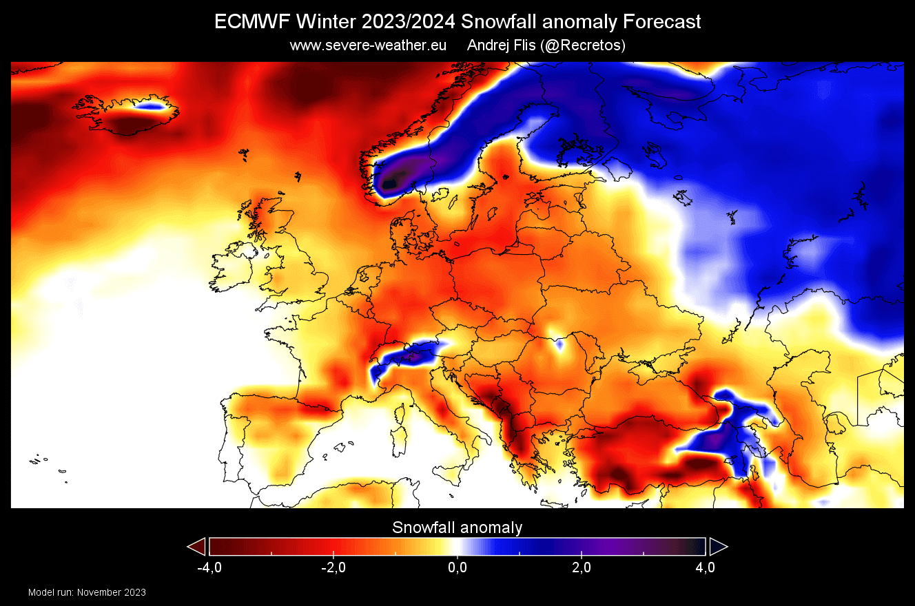
WINTER 2023/2024 ECMWF SNOWFALL OUTLOOK
We produced a special snowfall forecast from the ECMWF data provided by the Copernicus-EU project. It shows the average snowfall anomaly over a 3-month period (December-February).
Over Europe, we see mostly below-average snowfall, except over parts of Scandinavia and the Alpine region. This reflects a dominant westerly pattern, bringing more moisture and less cold from the North Atlantic. But, this can have high variance, as less snowfall does not equal to no snowfall, so there can be strong weekly periods with cold and snow lost in the 3-month average.
Over North America, the ECMWF suggests more snowfall than usual across much of the central Plains, southeastern, and parts of the eastern United States. The rest of the regions do show less snowfall, but the negative anomaly is not as strong as in Europe. Also, considering the pressure pattern, the eastern United States does seem to have the best snowfall potential compared to the long-term average.
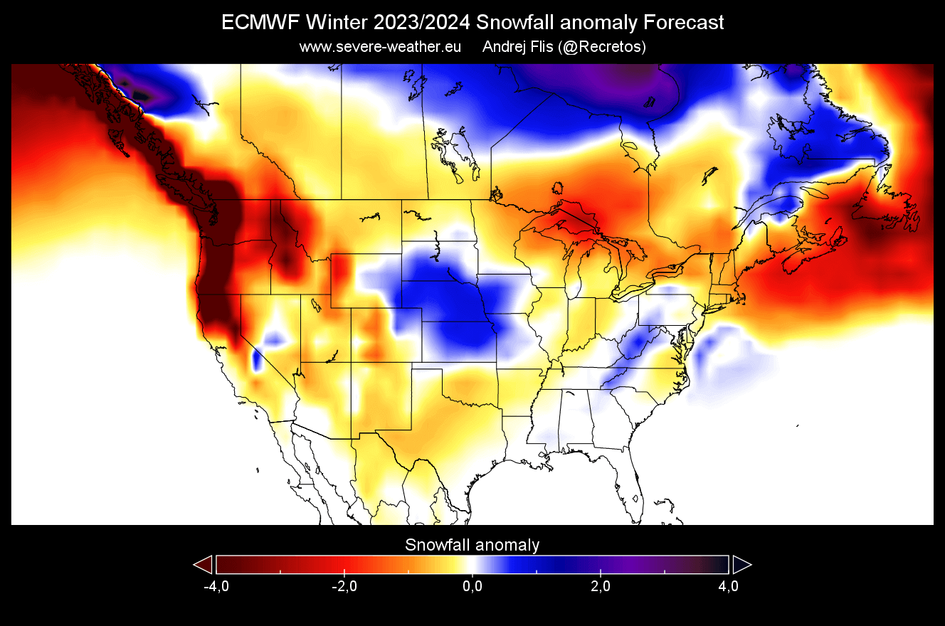
Looking at Canada, you can see increased snowfall across the central and eastern parts of the country, while less snowfall is forecast across deep southern Canada and the Pacific Northwest.
Remember that this is a 3-month average, and the month-to-month snowfall potential can be very different. Especially going into the mid and late-winter season.
UKMO WINTER FORECAST
Long-range weather forecasting is said to be half science, half lottery. We look at trends and probabilities, but the variation is still key. The more forecast data you can look at, the better idea you can get what the most possible scenario is.
As you can never trust a single forecast model, we use the UKMO long-range forecasting system along the ECMWF. It is run by the United Kingdom Met Office.
The winter pressure pattern forecast from UKMO is similar to the ECMWF. We have a high-pressure zone over Canada and Greenland. A low-pressure zone is forecast across the United States, carrying on into the North Atlantic.
An interesting anomaly in this forecast is the low-pressure zone over Europe. It is placed well inland and would enable a few good situations with a northerly flow over the continent.
Looking at the surface temperature forecast over Europe, the forecast here is not as widespread warm as in the ECMWF. That is due to the low-pressure system forecast over the continent, enabling more north flow than the ECMWF. The forecast is still warmer than normal, but the pattern allows for much more cold opportunities across the western and central parts.
Over North America, the UKMO forecast shows a very similar picture to the ECMWF. Warmer than normal over Canada and the northwestern United States. But a neutral-to-cold zone across the central and eastern United States.
Such a temperature pattern for the eastern United States is emerging across several different modeling solutions. That increases the confidence in this scenario overall. While this temperature forecast only shows a lack of warm anomalies, that is very telling.
The precipitation forecast is pretty much the same in both models. Europe features more precipitation across much of the continent, especially northern and central parts.
The precipitation anomaly forecast for North America again shows the El Niño-type pattern over Canada and the United States. More precipitation over the southern and eastern United States and drier conditions over the northwest.
This is due to the stronger subtropical jet stream forced by the El Niño anomaly. We will learn more about this event and its winter influence.
OCEANIC WINTER INFLUENCES
El Niño Southern Oscillation (or ENSO) is a region of the equatorial Pacific Ocean that changes between warm and cold phases. Typically, there is a phase change around every 1-3 years.
We are currently in a warm phase called El Niño. The cold ENSO phase is called La Niña, which was impacting our past three winters.
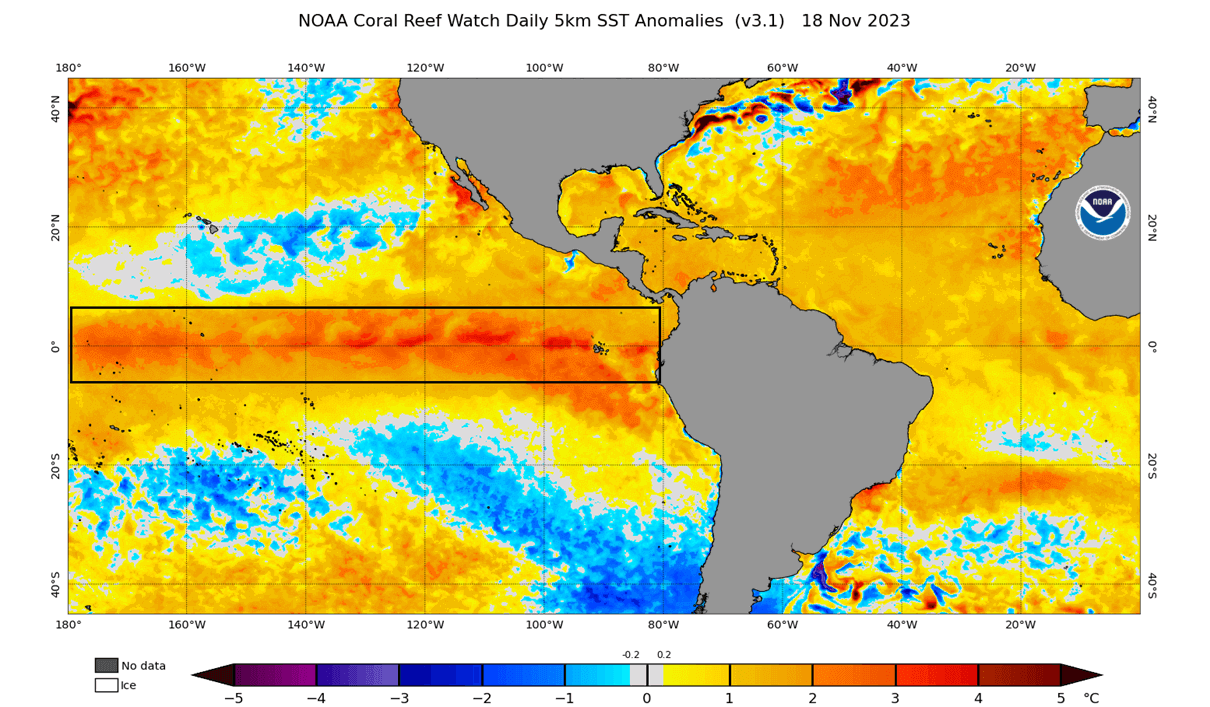
You can see the El Niño in NOAA’s latest ocean anomaly analysis below. It stands out as an area of above-normal ocean temperatures across the equatorial Pacific Ocean. This anomaly affects the atmosphere but also tells us that the weather patterns are changing global scale.
We produced a video showing the ocean anomalies from late Winter to Summer to better understand the ENSO development.
The cold ocean anomalies quickly broke down at the beginning of the year, with warm anomalies emerging in early Spring. This signaled a fast growth of the warm ENSO phase.
El Niño significantly influences tropical rainfall, pressure patterns, and the complex ocean and atmosphere exchange. With some delay, these changes affect circulation over the rest of the world.
The following image below from NOAA Climate shows the typical circulation during an El Niño event. While the event is active, the rising air in the eastern Pacific causes more storms and precipitation and lowers the pressure over that region.
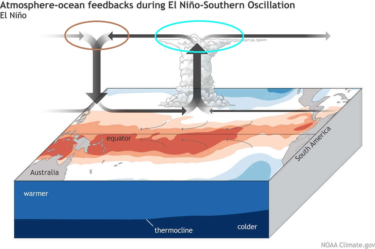
At the same time, the air descends in the western Pacific, causing stable weather and high-pressure conditions.
This way, El Niño significantly impacts the tropical rainfall and pressure patterns and overall impacts the ocean-atmosphere feedback system. Through this system, the ENSO influence spreads globally.
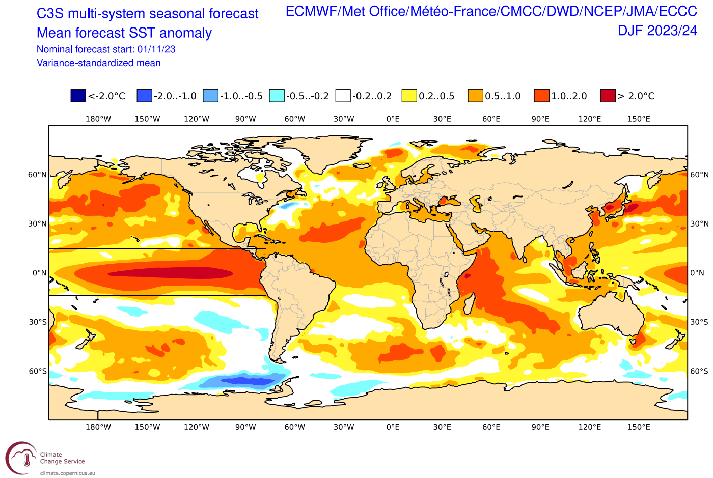
Looking at the extended seasonal ENSO forecast from ECMWF below, you can see the ensemble agreement for a strong El Niño event, peaking around +2 above normal. The anomaly in this forecast basically refers to the strength of the above-normal ocean temperatures in the tropical Pacific regions.
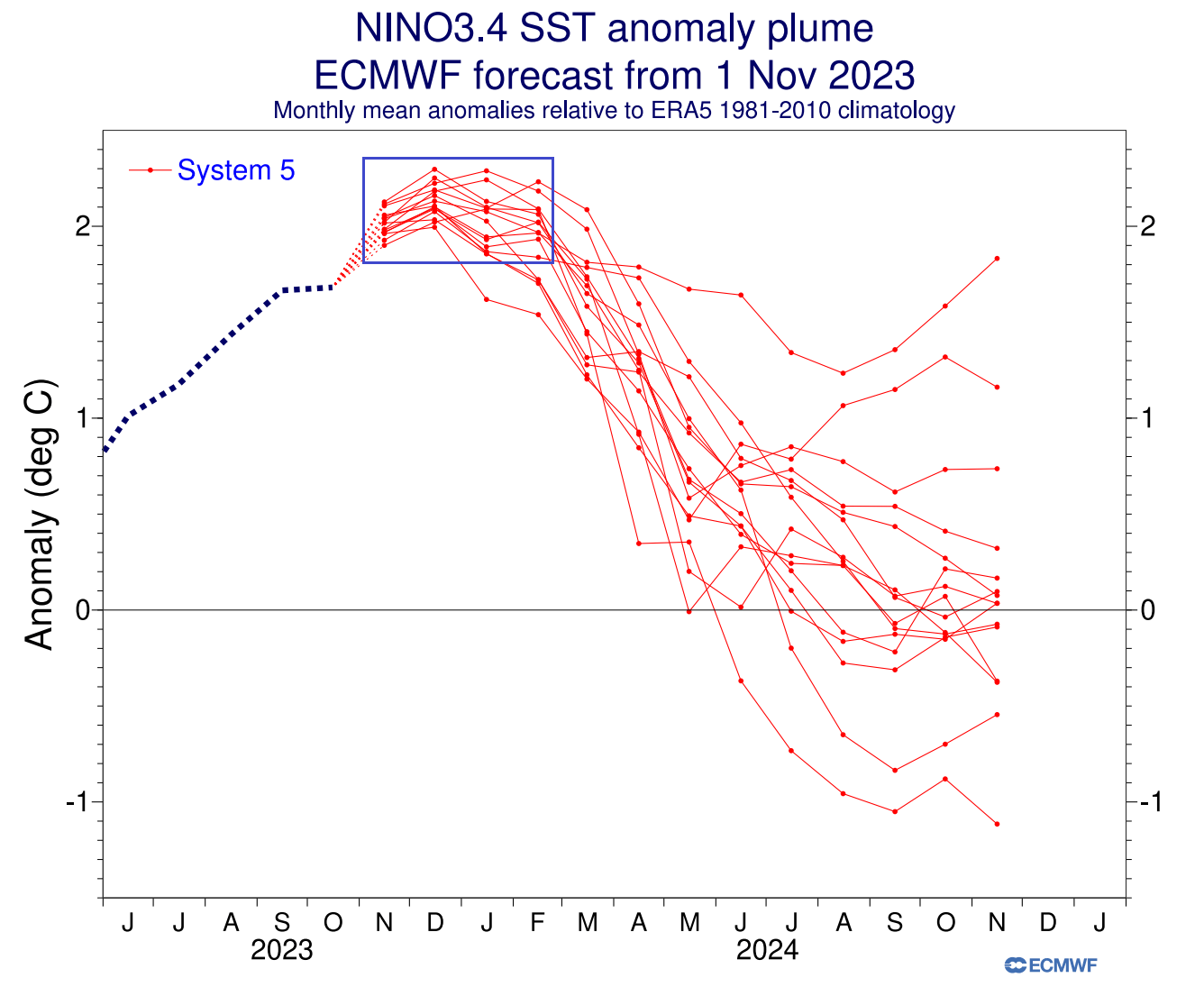
The stronger the anomaly, the stronger the event, and the stronger its global impact on weather. Looking at the forecast, this El Niño event is forecast to weaken over 2024 but will still influence the spring season.
Below is also an ocean surface anomaly forecast for the winter period Dec-Feb. You can see the El Niño anomaly in the Pacific Ocean. An event of this magnitude is strong enough to have a profound atmospheric response worldwide.
But we can now go away from the ocean and look into the atmosphere, for some of the weather changes from the El Niño.
DOES OCEAN RUN THE WEATHER?
Typically, the first influence of these ocean anomalies can be seen in the changing jet stream. The jet stream is a large and powerful stream of air (wind) at around 8-11km (5-7mi) altitude.
The jet stream is a very important piece of the Winter story. It is one of the main ways El Niño can change the weather patterns more directly, especially over North America, which is very close to its regions.
During the El Niño winter season, there is typically a strong and persistent low-pressure area in the North Pacific. That pushes the polar jet stream further north, bringing warmer-than-normal temperatures to the northern United States and western Canada.
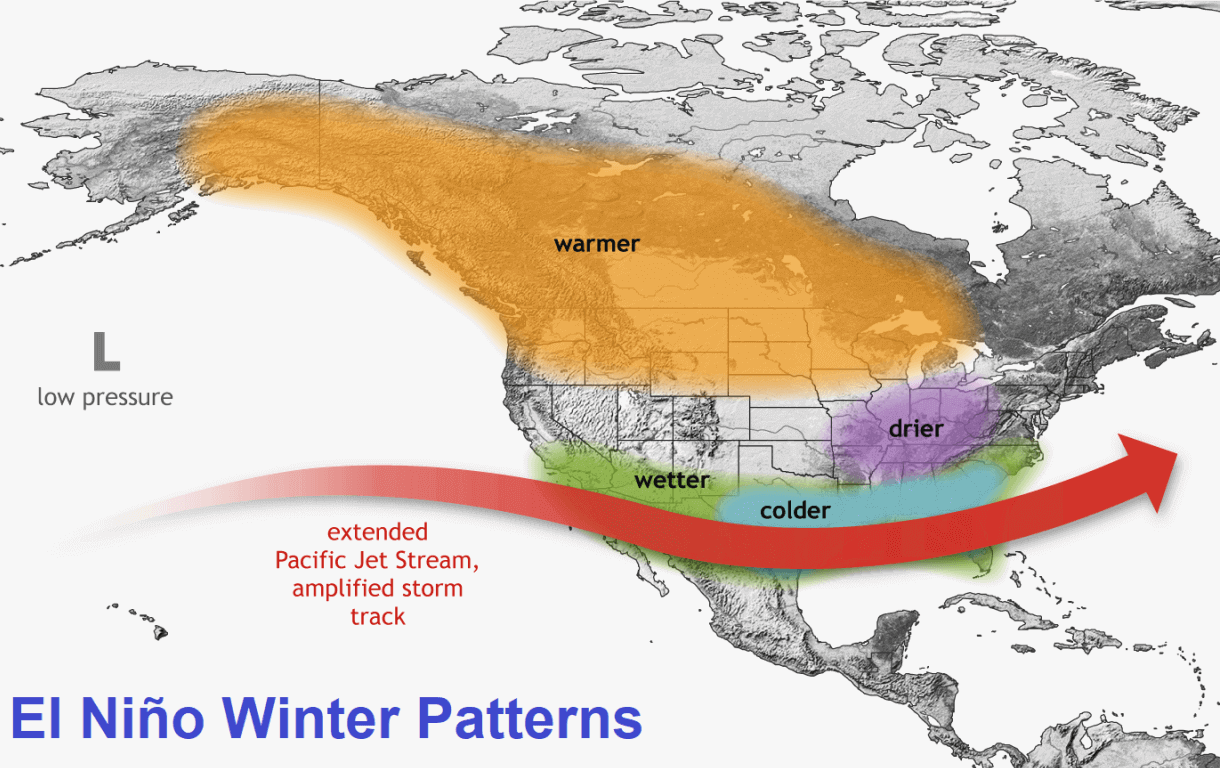
But the southerly Pacific jet stream is extended and amplified during an El Niño, bringing low pressure and storms with lots of precipitation and cooler weather to the southern United States.
You can see exactly that in the image below, which shows the average winter pressure anomalies for past El Niño winters. You can see the low-pressure area in the North Pacific and a high-pressure zone over Canada. A low-pressure storm track and precipitation spans the southern United States.

Another high-pressure area is over southern Greenland and northwestern Europe. This helps to produce a more northerly flow over central and northern Europe but can vary greatly with other dynamics at play there.
Below is a new image by NOAA Climate, which shows the number of past El Niño events that were more often warmer or colder. A pattern is seen that El Niño winters are mainly colder than average across the southern half of the United States and up into the northeast.
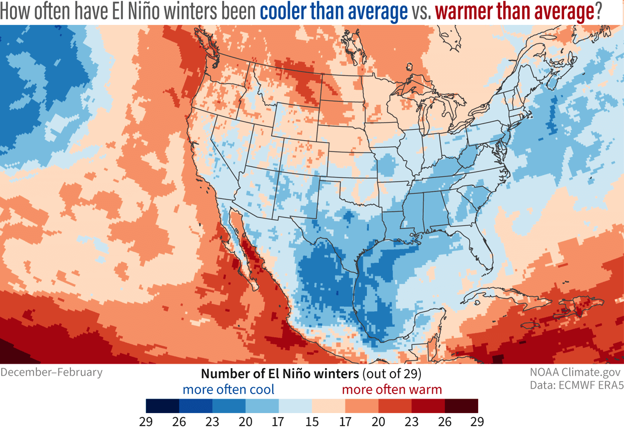
Warmer than average El Niño winters are usually over the northern Plains, upper Midwest, and the Pacific Northwest.
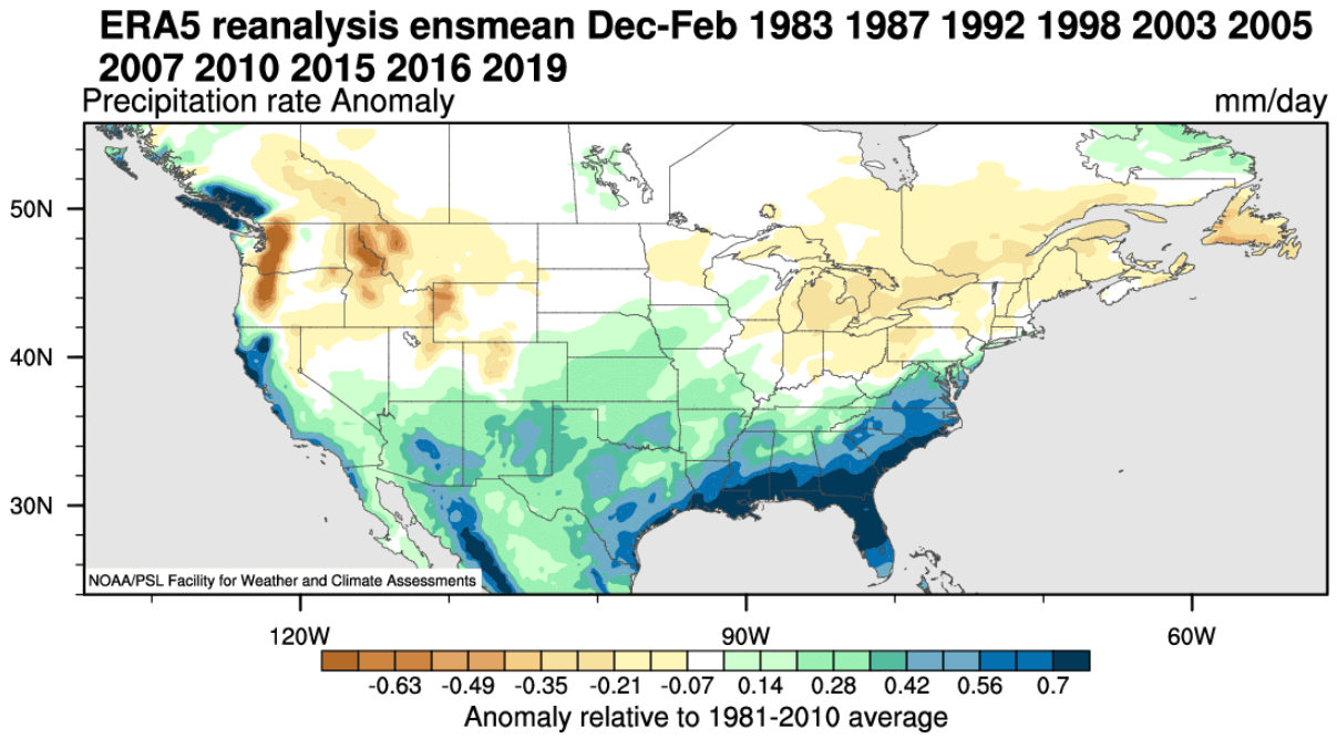
Precipitation-wise, an average El Niño winter brings more precipitation to the southern half of the United States, especially to the Southeast. Drier winter conditions prevail in the northwestern United States and around the Great Lakes.
Of course, what about snow?
El Niño also changes the snowfall patterns, as seen in the image below. Some of the areas with more snowfall during an El Niño include New England, parts of the mid-Atlantic, parts of the mid-south, the southeastern United States, as well as the plains, four corners, and southwest. Image by meteorologist Ben Noll.
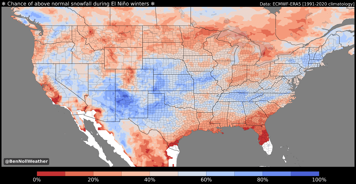
This is mainly due to low-pressure systems trailing across the southern United States. More moisture increases the chances of snowfall in the southern half if enough cold air is available.
Less snowfall is usually seen across the deep southern United States, Ohio Valley, Midwest, northern Plains, northern Rockies, and Pacific Northwest.
After passing Canada and the United States, the jet stream moves into the North Atlantic, where it can take different paths toward Europe.
EUROPE AND ENSO
The ENSO effects are much less pronounced in Europe than in North America because other factors are also involved, like the existing North Atlantic pressure pattern.
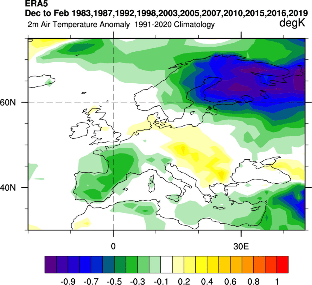
But we still tried to find a possible historical connection of ENSO to Europe. For this reason, we produced two graphics below for temperature and precipitation based on combined data from past El Niño Winters.
Looking at temperature first, we can see an interesting cold signal over northern Europe. There is also a cooler signal over western Europe, while the temperatures are higher than normal around central parts.
The precipitation composite shows more precipitation in northwestern Scandinavia and parts of central and southeastern Europe. Western Europe is usually drier in an El Niño winter.
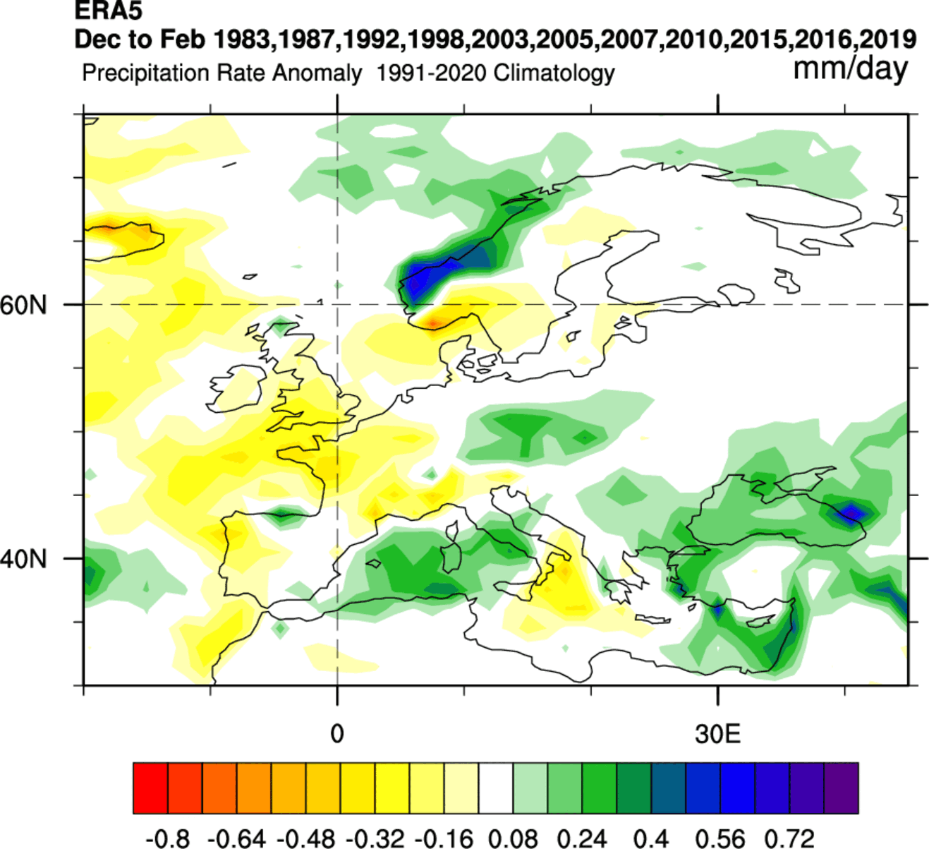
The highest snowfall potential looks to be over and around the Alpine region and towards the higher elevations of southeastern Europe. And, of course, over northwestern parts of Scandinavia.
There is not much around this signal, as it would take more filtering and deeper science to clear the result. But the prevailing idea can be seen.
WINTER 2023/2024 FINAL FORECAST SUMMARY
Reading images and descriptions can only give you so much, or sometimes too much. To simplify everything, here is what the latest Winter season 2023/2024 forecast has to offer in a short version:
Europe is expected to have warmer-than-average temperatures over most of the continent. Colder temperatures will be more defined in the northern and northwestern parts of the continent.
This means that the main weather mode over Europe is likely to be westerly, meaning a warmer, moist flow from the North Atlantic into Europe. The potential snowfall scenarios are limited to higher elevations and individual cold events, which cannot be resolved in a 3-month average.
The models do not fully agree on the pressure patterns in the North Atlantic. The main key is the positioning and strength of a potential high-pressure zone over Iceland/Greenland relative to the North American pattern.
Precipitation-wise, normal to increased precipitation is expected over much of Europe. The snowfall forecast shows less snowfall over Europe, despite more precipitation, except for the higher elevations.
North American winter forecast looks increasingly likely to be an interesting El Niño-type winter. Most of Canada and the northern United States will be warmer than normal under a weaker polar jet stream.
With the stronger subtropical jet stream from El Niño, normal to cooler temperatures are expected across the southern and eastern parts of the United States.
The subtropical jet stream will bring a lot of moisture, so more precipitation is expected across much of the southeastern and eastern United States. Less precipitation is forecast for the Pacific Northwest.
Based on the available data, the main trends point to a slow start to Winter in December, with cold air anomalies expanding across the central and eastern United States in the mid to late Winter.
We will keep you updated on the developing weather trends in the coming weeks, so make sure to bookmark our page. Also, if you have seen this article in the Google App (Discover) feed, click the like button (♥) there to see more of our forecasts and our latest articles on weather and nature in general.
Don’t miss: