The latest development in the Stratosphere is very dynamic, with the Polar Vortex currently running stronger than normal. But in the coming weeks, the forecasts already show an upset in the form of a stratospheric warming wave and some following colder weather trends appear over the Christmas holidays in the eastern United States.
First, we will quickly look at what the Polar Vortex is and why we care about it each Winter. Then, you will see the latest status of the Polar Vortex and its strong cold anomaly and how it is all forecast to come down in December.
Below is the latest 16-day temperature change forecast in the Stratosphere in early December, showing a warming wave event starting to unfold. But more on that further down.
WEATHER CIRCULATION IN THE ATMOSPHERE
To understand what the Polar Vortex is, we can try and visualize it. In simple terms, it is just a name that describes the broad winter circulation over the northern (and southern) hemispheres.
Below, you can see a 3-dimensional image of the Polar Vortex. The vertical axis is greatly enhanced for better visual presentation. It basically shows the actual structure of the Polar Vortex, connecting down to the lower levels and to the pressure systems.
The Polar Vortex extends high up into the atmosphere. The lowest level of the atmosphere is called the troposphere, where all the weather events are. But above that, we have the Stratosphere, a deeper and drier layer and the home of the ozone layer.
Because both layers are very different, we separate the entire Polar Vortex into an upper (stratospheric) and a lower (tropospheric) part. They both play their role differently, so we monitor them separately. But it is also very important if they are properly connected—image by NOAA.

The upper (stratospheric) part is more circular and symmetrical as it spins higher above the ground, with fewer obstacles in its flow.
But, the lower structure of the Polar Vortex is much more uneven and regularly disrupted. That is due to the influence of the terrain/mountains and strong pressure systems acting as obstacles.
The Polar Vortex behaves like a very large cyclone, covering the whole north pole down to the mid-latitudes. It is connected through all atmospheric levels, from the ground up, but can have different shapes at different altitudes.
To put the Polar Vortex into perspective, we produced a high-resolution video below, showing the Vortex spinning over the Northern Hemisphere in the Stratosphere at the 30mb level, around 23km/14miles altitude.
The main takeaway from the video should be that the Polar Vortex is not just one winter storm or a cold outbreak that moves from the Midwest into the northeastern United States.
It is one large cyclonic area spinning over the entire Northern Hemisphere, from the ground up to the top of the Stratosphere and beyond, reaching over 50km/31miles altitude.
When monitoring the Polar Vortex, we know that it mainly has two modes of operation during the cold weather season:
A strong/stable Polar Vortex usually means strong polar circulation and jet stream. This contains the colder air into the Arctic Circle, creating milder conditions for most of the United States and Europe.
In contrast, a weak/disrupted Polar Vortex creates a weak jet stream pattern. As a result, it has a harder time containing the cold air, which can now escape from the polar regions into the United States or Europe. Image by NOAA.
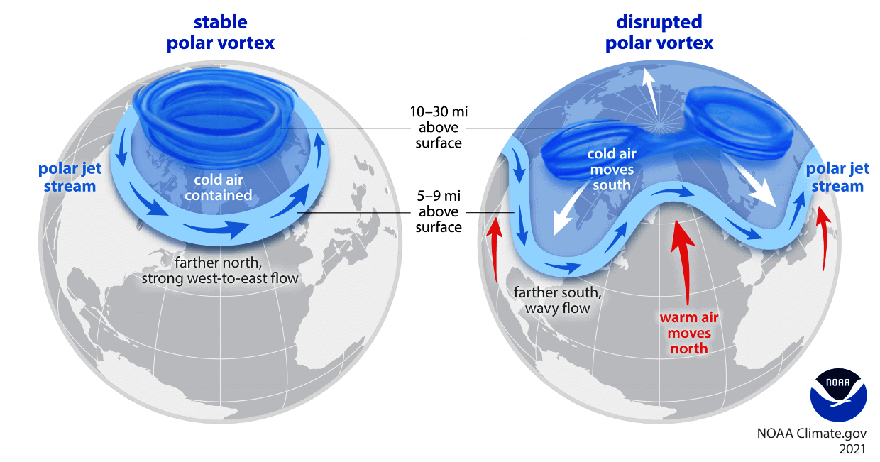
So, if you want a colder and snowier Winter, your odds are highest with a weak Polar Vortex. A weak Polar Vortex essentially means a breakdown or, at the very least, a disruption of the stratospheric circulation.
That is usually achieved by increasing the pressure or temperature in the polar Stratosphere. We call such events “Sudden Stratospheric Warming”. As the name suggests, it is a rapid temperature increase in the Stratosphere.
But not every disruption event is a major Stratospheric Warming event. As you will see, even smaller disruptions can influence the Polar Vortex and the weather at the surface.
LATEST POLAR VORTEX STATUS
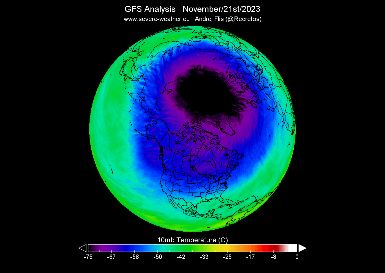
The cooling over the North Pole is in full swing. It usually starts in August, increasing strongly over September and October. Finally, the Stratosphere reaches its coolest period in November and December, when the Polar Vortex is usually at its strongest.
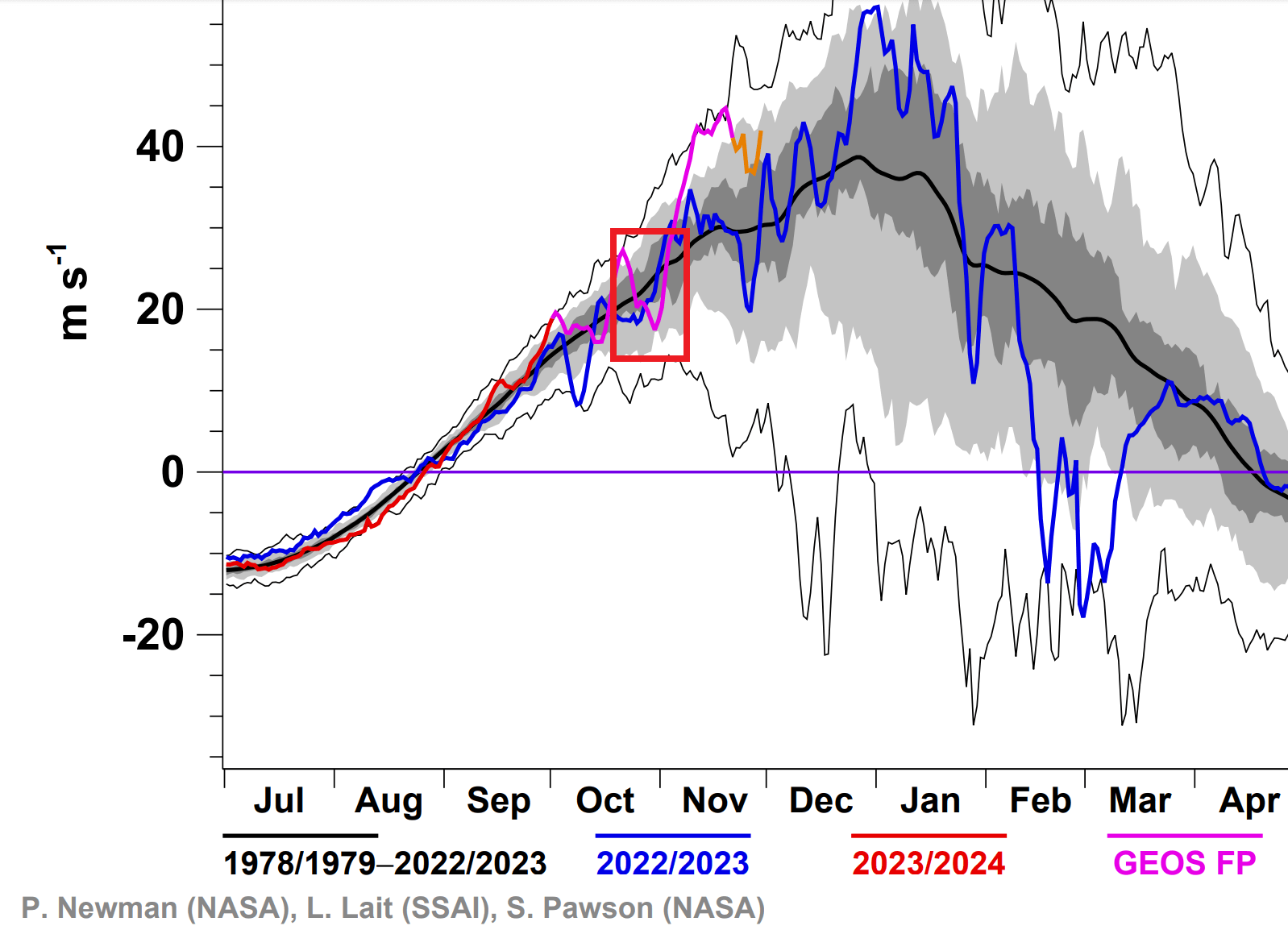
Below is NASA latest analysis graph for temperature in the mid-stratosphere over the north pole. The blue line is last year, and the grey/white areas are historical data. The red square marks the month of November so far.

You can see the violet line, which is the latest analysis. It shows that the Polar Vortex is running quite colder than normal in November so far but at similar levels as last year.
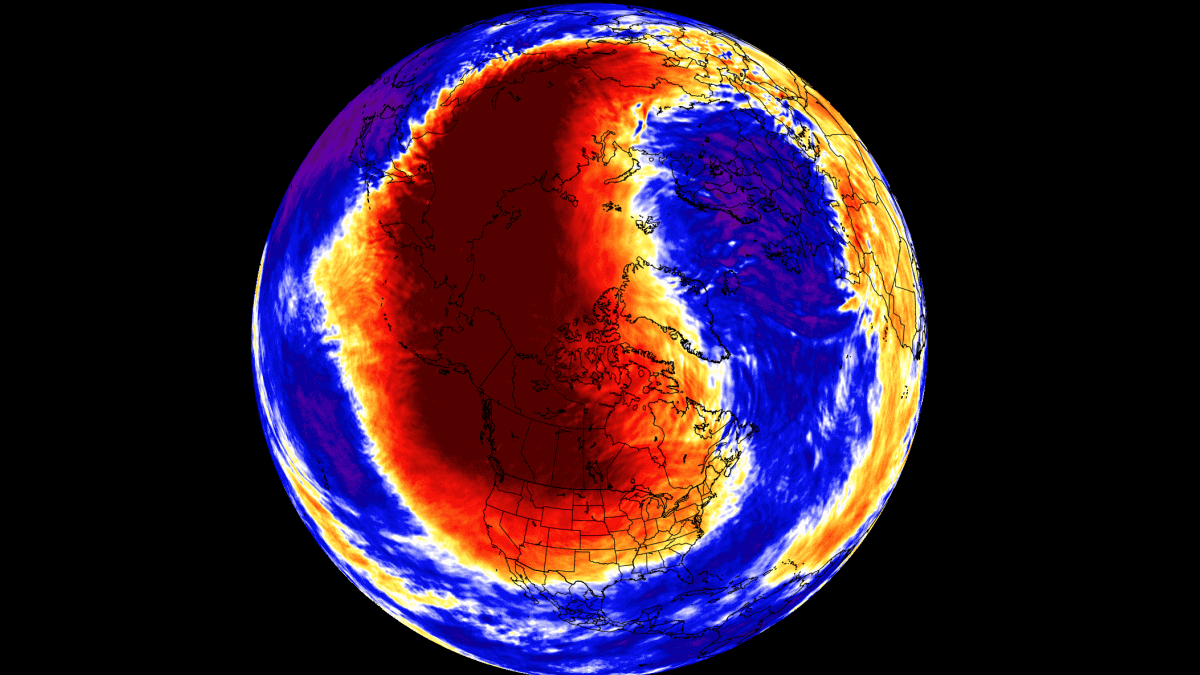
The temperature was still dropping this month in the Stratosphere. In the image below, you can see the temperature change in the past 30 days in the stratosphere at around 30km/18.5miles altitude. It shows a strong cooling process over and around the North Pole.

Looking at the actual temperature analysis, we can see a very strong cold core over the polar circle. This is the heart of the Polar Vortex, and the colder it gets, the stronger the Polar Vortex can become. That is because it feeds off the temperature/pressure difference between the polar and the southern regions of the Northern Hemisphere.
The pressure analysis reveals that in the image below. It shows the geopotential height of 10mb level (30km/18miles altitude). You can see the core low-pressure area over the polar circle, with the Polar Vortex having a very organized cyclone-like shape as a proper planetary scale low-pressure circulation.

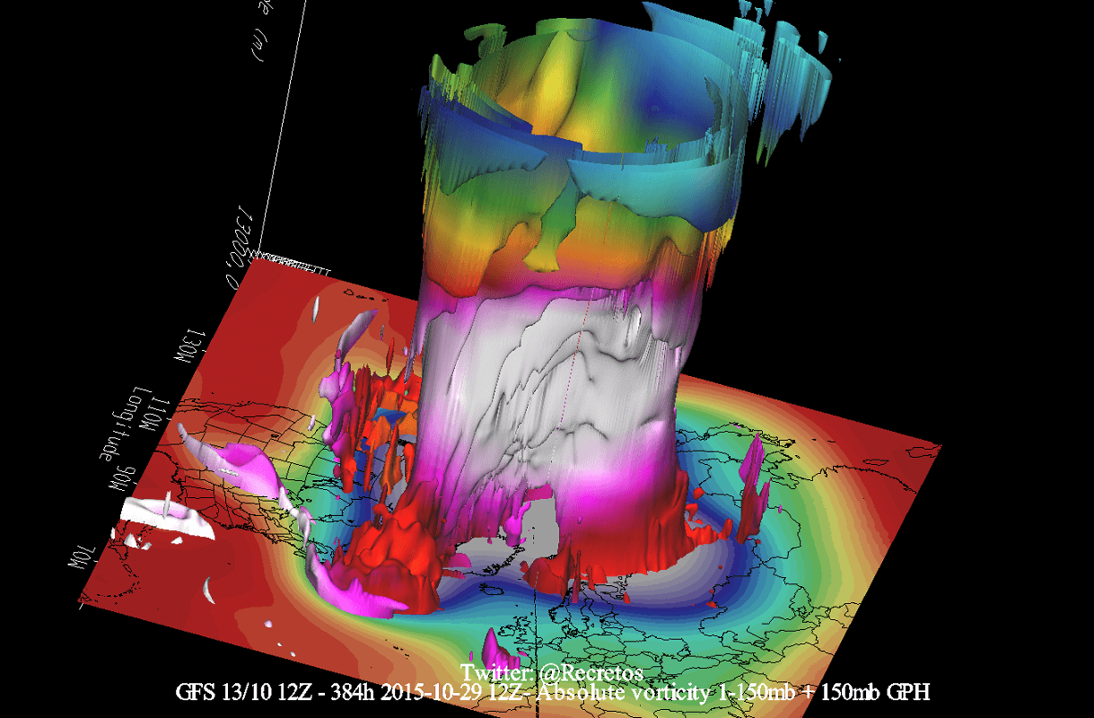
The 3-dimensional Polar Vortex analysis shows a good structure appearing in both upper and lower atmospheric levels. This reflects a good system with a strong cold core and a broad circulation pattern in the stratosphere.

Speaking of wind, the latest wind analysis below shows the stratospheric jet stream at the 10mb level (mid-stratosphere). This is called the Polar Night Jet. You can see the main shape/outline of the stratospheric jet, having a very good circular shape driven by the pressure and temperature differences.
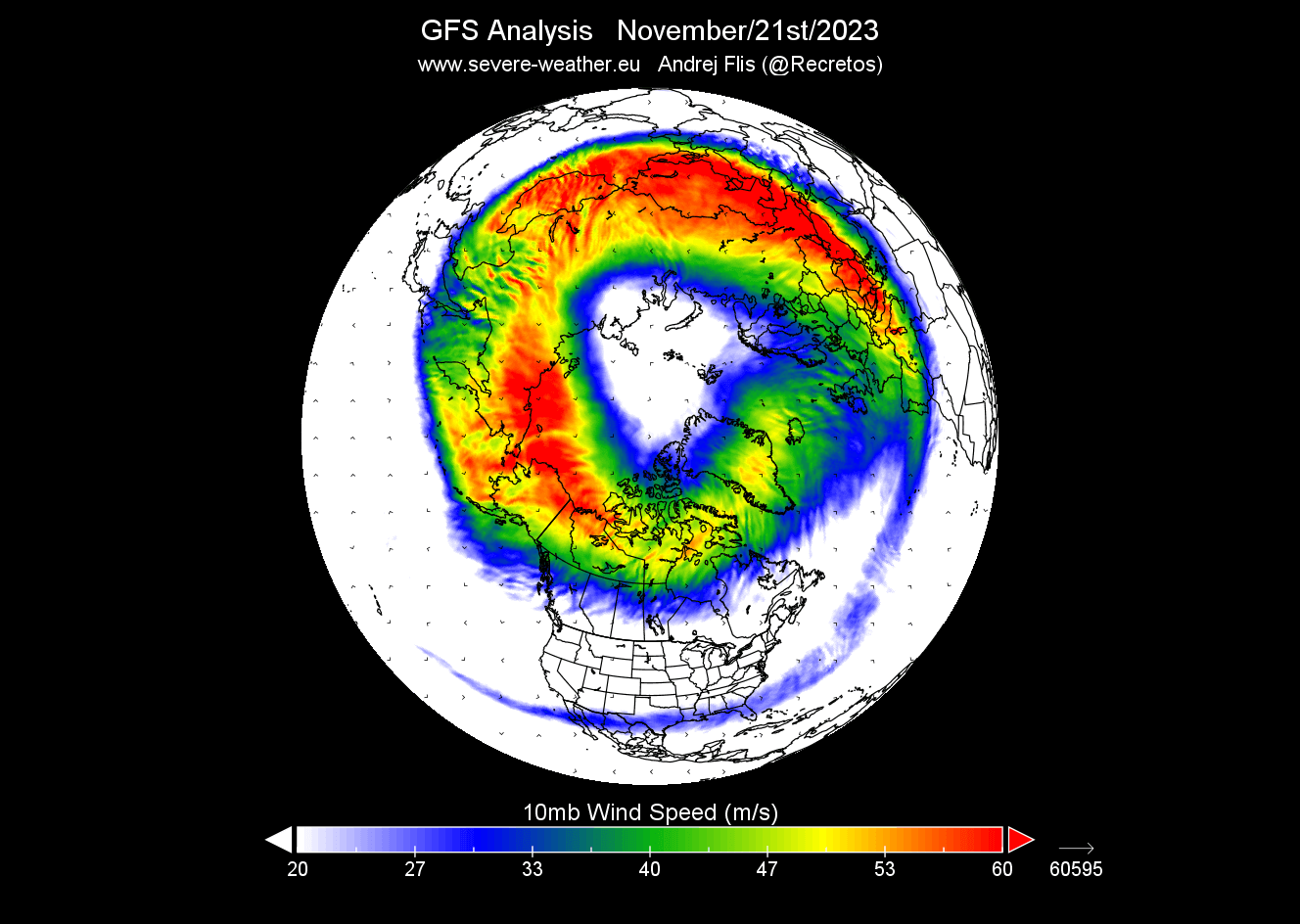
Stratospheric winds can tell us a lot about the state of the Polar Vortex, and we even use it to determine how strong/stable it is now and in the future.
A good example is seen in the extended forecast, with a stratospheric warming event starting to appear in December, with the potential to impact surface weather patterns.
STRATOSPHERIC WARMING FORECAST
The strength of the stratospheric jet stream at the 10mb level is usually used to determine the strength of the Polar Vortex and its potential influence on the weather. This is especially the case during the mid-winter when it is usually at its strongest.
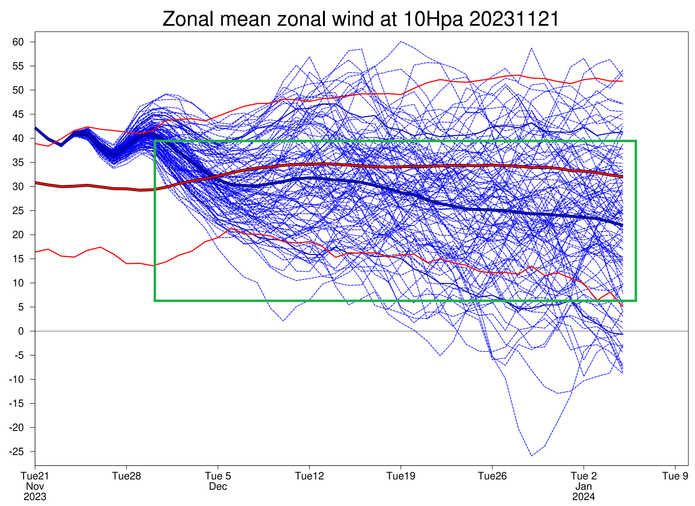
Compared to the long-term average, current data show that the strength of the Polar Vortex is at an all-time high level.
That is seen in the image below, which shows the ECMWF forecast of the stratospheric Polar Vortex winds at 10mb (~30km/18.5miles). The thick red line shows the average level. But notice the green marked area, which actually shows a deceleration (weakening) of the Polar Vortex going into December.
Below is the temperature forecast from GFS, showing the 16-day temperature change in the stratosphere compared to now. You can see a substantial warming area developing over Siberia and extending all the way over North America. This is known as “Canadian warming”, a special subtype of a stratospheric warming event.

The extended ECMWF forecast below also shows a large warming anomaly in the stratosphere in mid-December, which indicates an ongoing event is likely. But what does such an event mean for the weather on the ground?

A lot depends on the actual strength of the warming event and the pressure anomalies in the lower levels. All we have for now are the forecast trends. Below is the surface temperature anomaly trend for mid-December.
The United States looks “neutral” with anomalies, pushing all the warm anomalies up into Canada. A similar look is over Europe, looking mostly warmer than normal in this time period.

But we showed this image above for a reason. It is to show that despite the stratospheric warming being forecast in the same week, any potential changes need time to manifest in the lower levels. The main activity is in the stratosphere, so there is some time delay for the effects to appear in the lower levels (if at all).
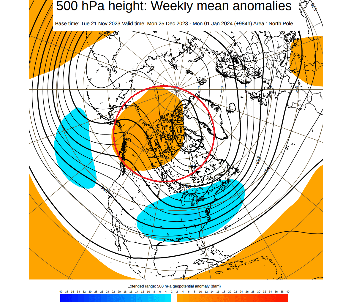
So now we look later into December, the final week from Christmas to New Year. The image below shows the pressure anomalies in that week. You can see a high-pressure anomaly over Canada. The natural response from a higher-latitude blocking high is the pressure drop over the central and eastern United States.
And looking at the temperature anomalies for the week between Christmas and New Year, you can see the cold anomalies across the eastern United States. This does look like a pattern that would follow a stratospheric warming event of this type/magnitude as currently forecast.
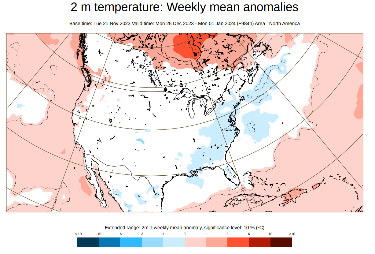
This basically shows colder Winter weather across the eastern and northeastern United States. Having some cold and even snow in the holiday week would certainly make many people happy across the eastern United States.
The Polar Vortex has the power to do many things regarding weather, especially during Winter when the pressure systems are strongest. A very common way that we can see weather pattern changes during Winter is with Polar Vortex disruption events.
One such example was already seen this season in late October and early November.
FIRST POLAR VORTEX DISRUPTION OF THE 2023/2024 SEASON
The first disruption of the Polar Vortex already occurred in late October. Below is the stratospheric wind analysis for the season so far. We have marked an area in late October. It shows a wind speed drop, which was linked to a temporary stratospheric Polar Vortex disruption.
You can see the October disruption below. The stratospheric Polar Vortex got pressed from both sides, courtesy of the Rossby wave-breaking events creating higher pressure in the stratosphere. This is similar to squeezing a balloon with both hands. Image by weatheriscool.
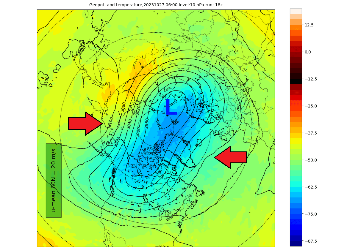
The evolution in the Stratosphere was simple. Going into the final day of the month, the Polar Vortex got compressed. But the big change was that the core of the Polar Vortex itself was displaced over Canada and the northern United States.

Below is the temperature analysis for the 1st week of November following the polar vortex disruption event we mentioned. The lower Polar Vortex core was displaced over North America, sending a cold air outbreak across the central, southern, and eastern United States.
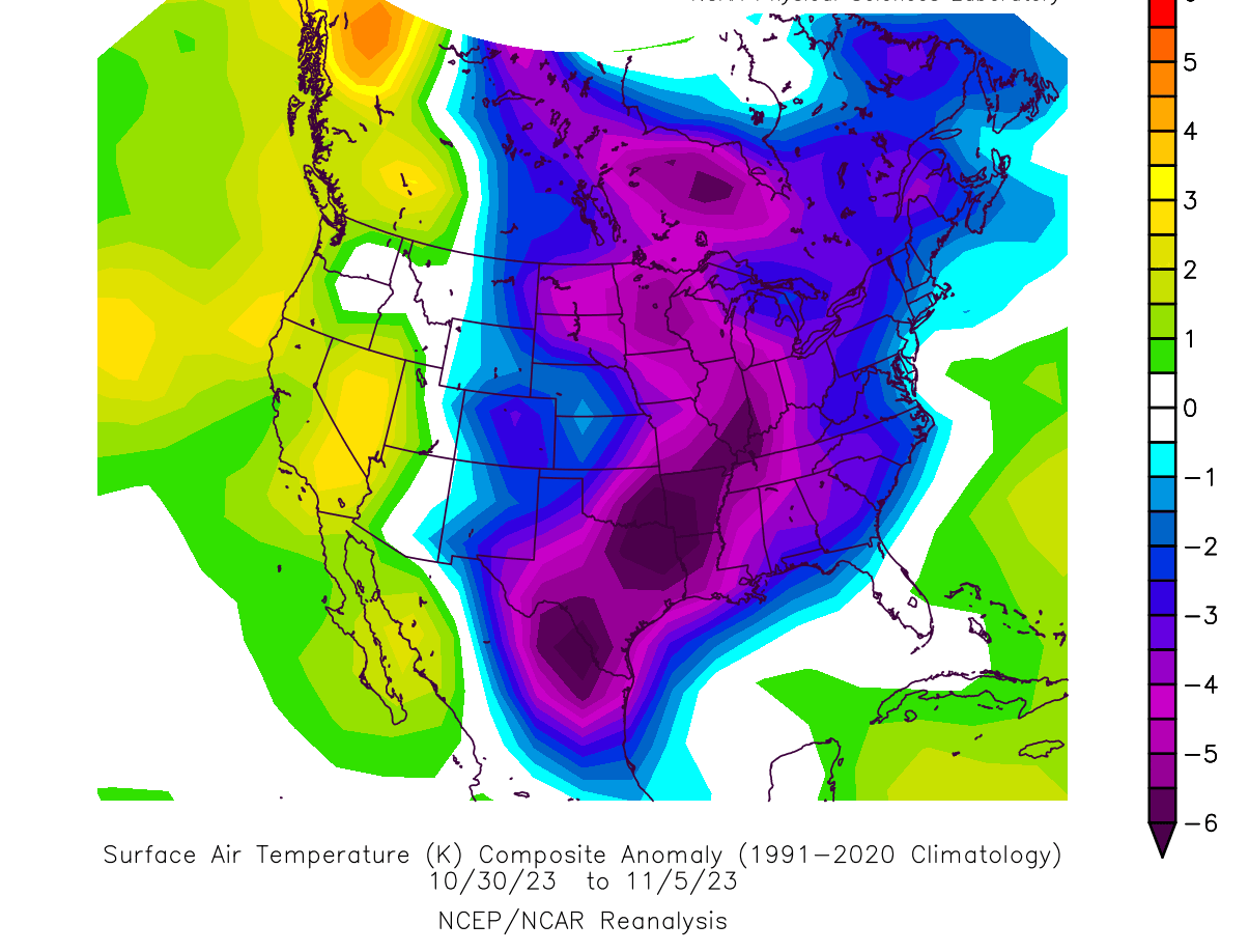
Since this was in late October, the air was not super cold despite the temperatures being much below normal. As we go into December, the air is overall colder, especially the source regions of the cold air up in Canada and the Polar Circle, from where the cold air drops into the United States.
This Polar Vortex disruption was a minor one. It only displaced the core of the Polar Vortex, which was enough for a single cold outbreak but was not sustained for a longer period.
But as we go into December, there is much more energy involved with the weather systems, including when that energy is sent into the stratosphere. That means that the chances increase for a larger Stratospheric Warming (SSW) event.
And the reason why a major stratospheric warming event is a big deal is because it can have a more widespread effect and also much longer-lasting.
MAJOR SUDDEN STRATOSPHERIC WARMING EVENT
Typically, a Polar Vortex weakens due to a rise in temperature and pressure in the Stratosphere. That is called a Sudden Stratospheric Warming (SSW) event, which can collapse the Polar Vortex.
To explain it in simple terms, a Sudden Stratospheric Warming event (SSW) is exactly what the name suggests. It is a sudden temperature rise in the polar Stratosphere during Winter. Warming of the Stratosphere means that the Polar Vortex is weakened and can collapse under pressure from the warming event.
This creates a chain reaction, disrupting the jet stream, creating high pressure over the Arctic Circle, and releasing the cold Arctic air into Europe and the United States.
An SSW event is usually triggered by specific pressure patterns in the lower levels that can send a lot of energy upwards vertically into the Stratosphere. The image below shows an example of a typical SSW event and how it progresses over a 30-day period.

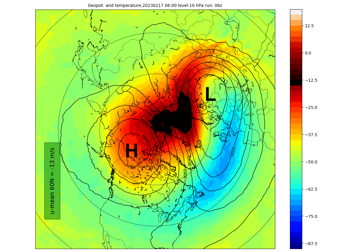
The most recent example of such a stratospheric warming event occurred in February this year. A strong warming wave took over the polar Stratosphere and the Polar Vortex. With the pressure rising in the Stratosphere and winds reversing, it was marked as a proper SSW event.
Looking at the first day of the SSW event below, you can see a large warming wave in the top and mid-stratosphere. It spread over the polar regions. Combined with a stratospheric high (H) covering the North Pacific and western Arctic, it has pushed and displaced the Polar Vortex (L) out of the North Pole.
In the 3D analysis below, you can see the small compressed Polar Vortex over Siberia. This is because a strong stratospheric high-pressure area (H) has taken over the Polar Regions and severely disrupted the atmospheric circulation in the higher and middle latitudes.

In the Stratosphere, you can see high-pressure anomalies from the Stratosphere connecting down to the lower levels. Again, this directly connects with the Stratospheric warming events, and the pressure patterns have responded with a strong blocked pattern.

The resulting pressure pattern below was fully established two weeks after the initial SSW event. The main result was a strong blocking high over Greenland, with the displaced low-pressure systems from the United States over the North Atlantic into Northern Europe.
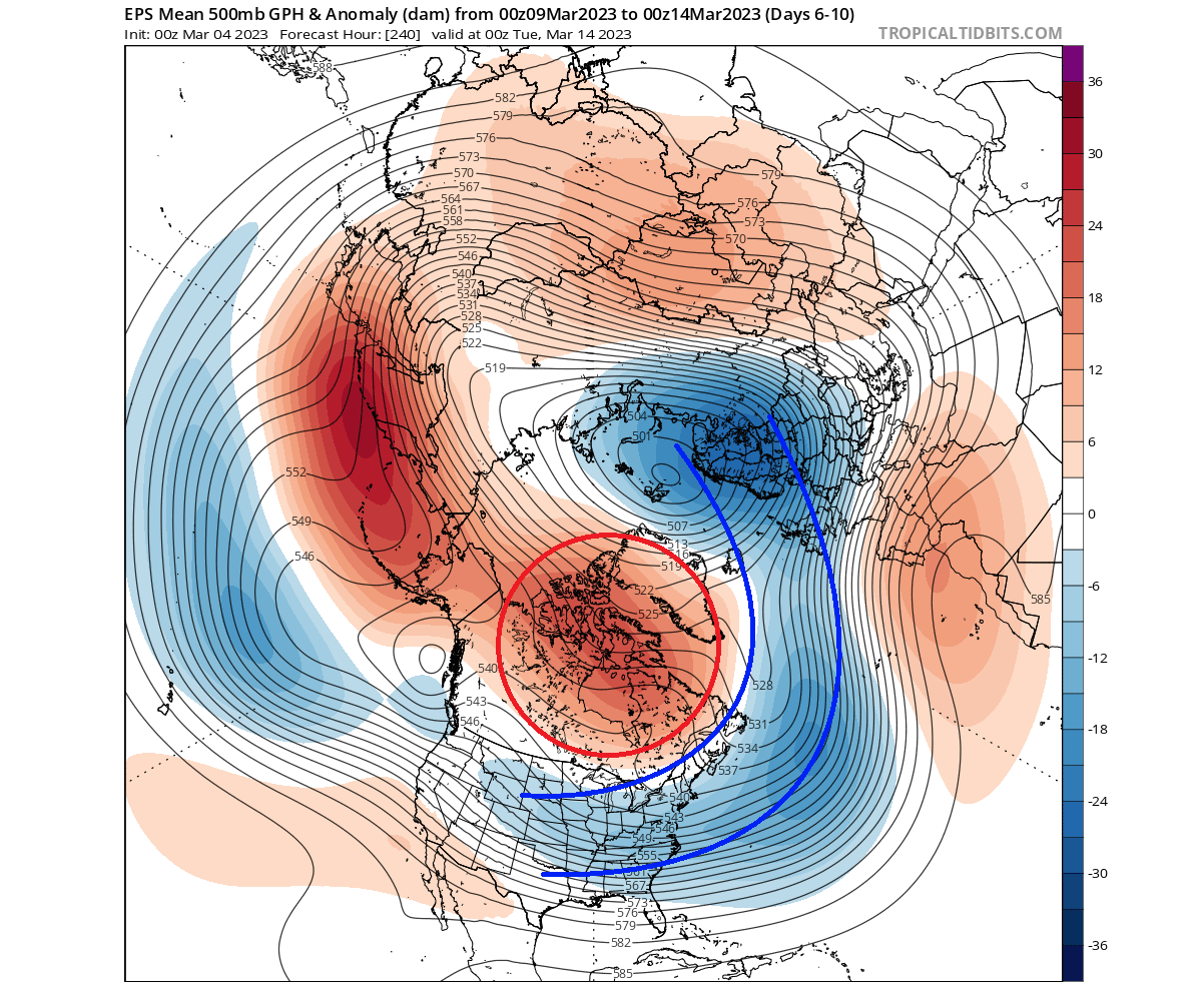
This pressure pattern is a typical weak vortex event. And as we showed in the intro, it means an easier escape of cold air down into the lower latitudes. But as the event was already in mid-March, some of the effects were limited compared to a full mid-Winter stratospheric warming event.
Looking at the temperature anomalies for that time, you can see a strong cold outbreak across the United States. The Greenland blocking system helps to push the cold air out of the polar regions, so a stratospheric warming event makes these scenarios much more likely in Winter.

There was no real cold air outbreak in Europe on a large scale, which also shows that a stratospheric warming event cannot always impact all regions with cold weather.
We will keep you updated on the global weather pattern development for the coming seasons, so make sure to bookmark our page. Also, if you have seen this article in the Google App (Discover) feed, click the like button (♥) there to see more of our forecasts and our latest articles on weather and nature in general.
Don’t miss: