April weather is forecast to rapidly alternate between two very different pressure patterns. A low-pressure area will influence the weather in the coming week, including snow over the Northeast. It will also influence the visibility of the total Solar Eclipse across the United States.
A high-pressure area is forecast to build over the United States in the following week, helping to bring warmer/seasonal weather and some stability across the United States.
We will first take a quick look at the atmospheric conditions last month, along with the stratospheric anomaly, and how the weather patterns will shift in the coming weeks, including during the Solar Eclipse.
WEATHER PATTERNS ABOVE AND BELOW
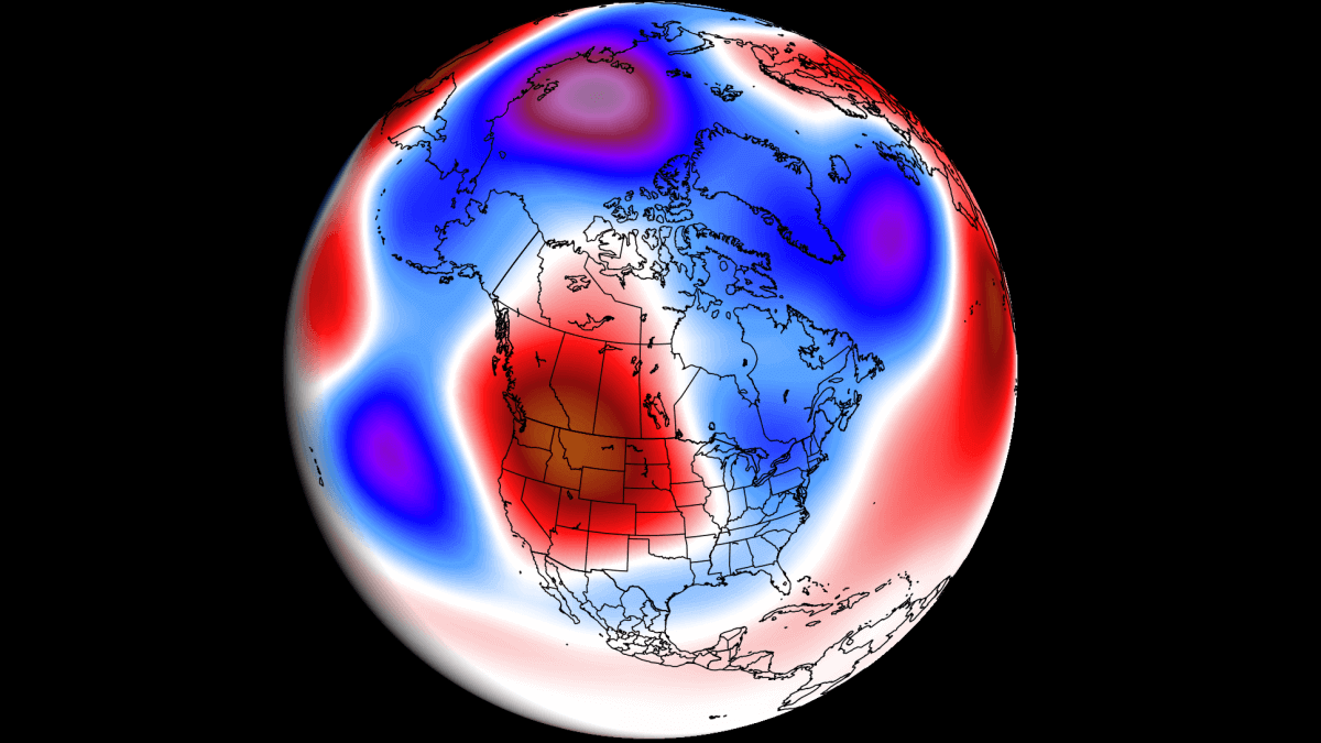
Looking back at March first, it was an interesting month with a lot of weekly pattern dynamics. The image below shows the 500mb pressure anomaly for the previous month. You can see that most of southern Canada and the western United States were under a semi-persistent low-pressure area.
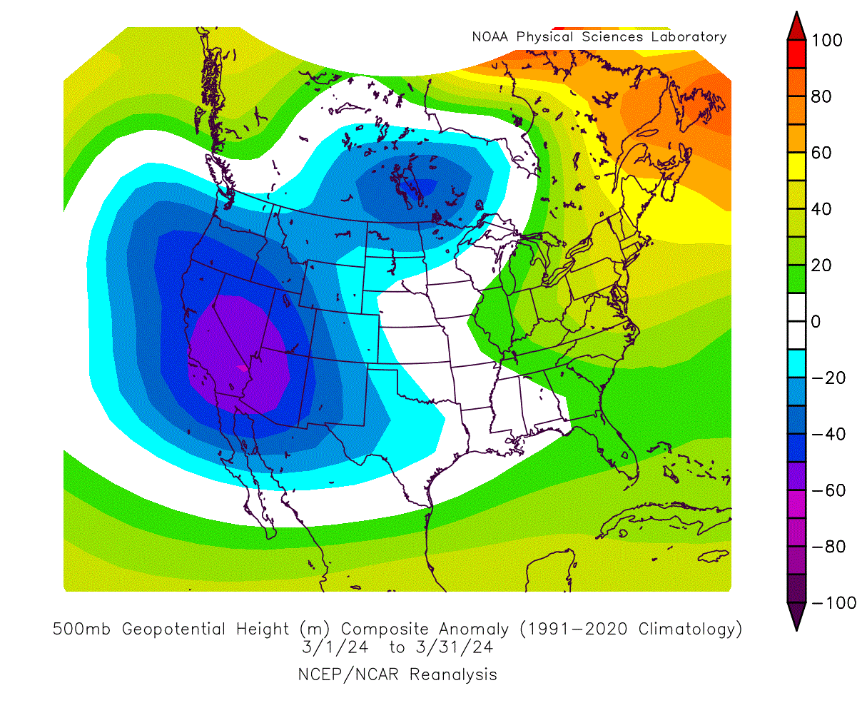 This was aided by the high-pressure ridging over the Aleutians and northeastern Canada. A low-pressure area spins counter-clockwise, so a low centered over the west brings a warm southerly airmass into the central and eastern United States.
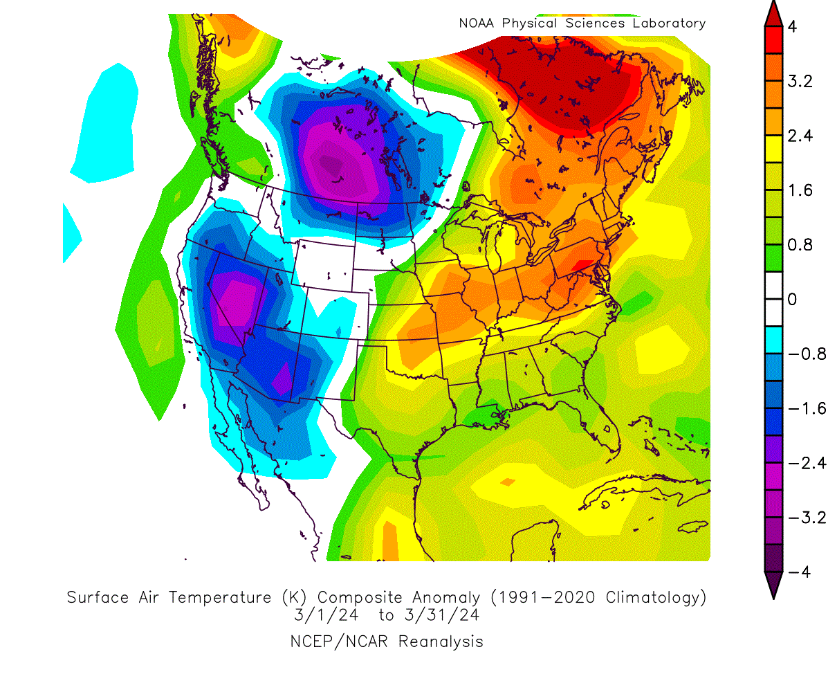
Below is a temperature anomaly analysis, which shows exactly this pattern. Warmer-than-normal temperatures were present over much of the central and eastern United States and eastern Canada. Northerly winds brought a cooler airmass down into the northern and western United States and southern Canada.
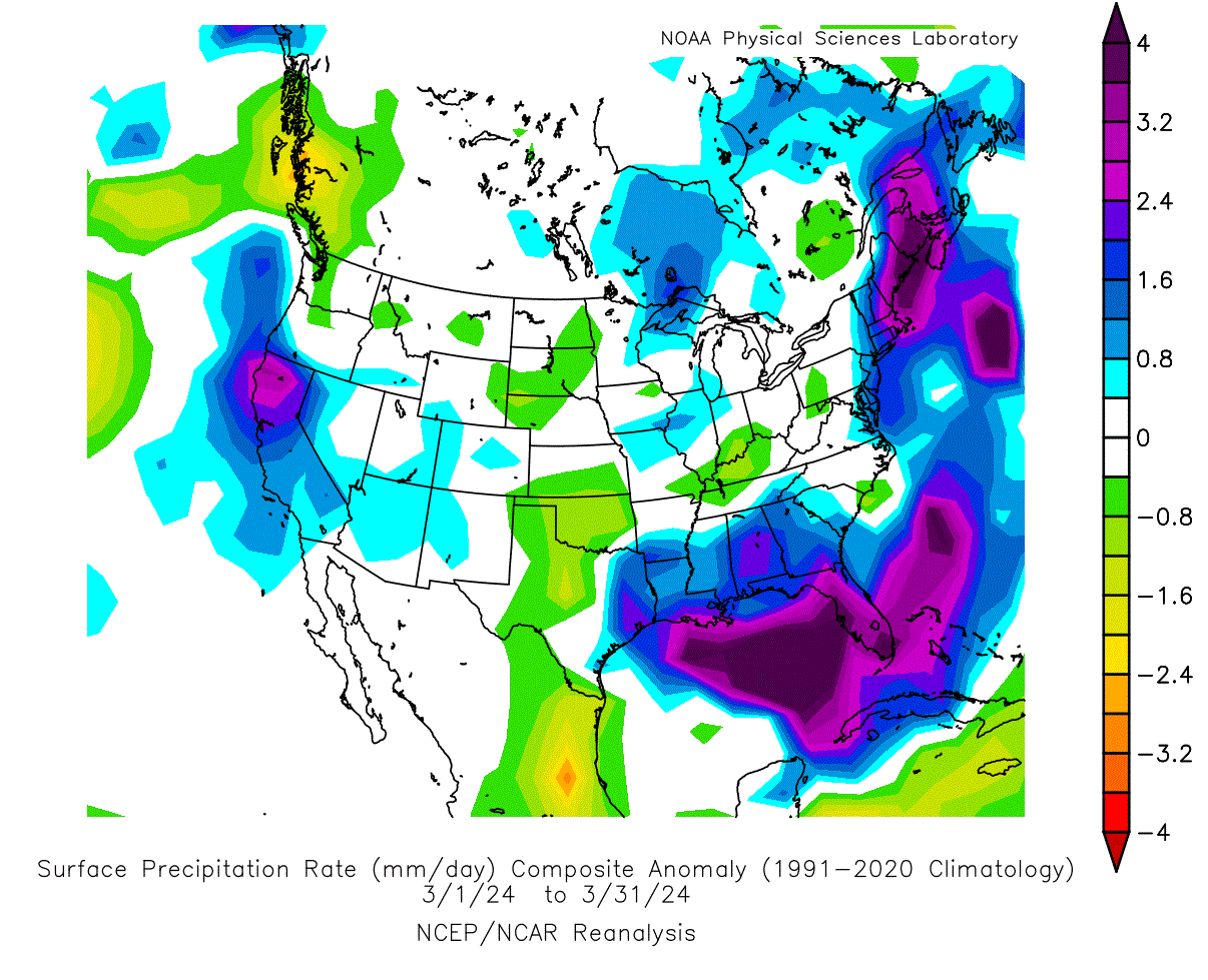
Pressure patterns also affect precipitation. The analysis below shows that there was more precipitation across the southeastern United States, the northeast, and California. Less precipitation was detected across the plains and the Ohio River Valley.
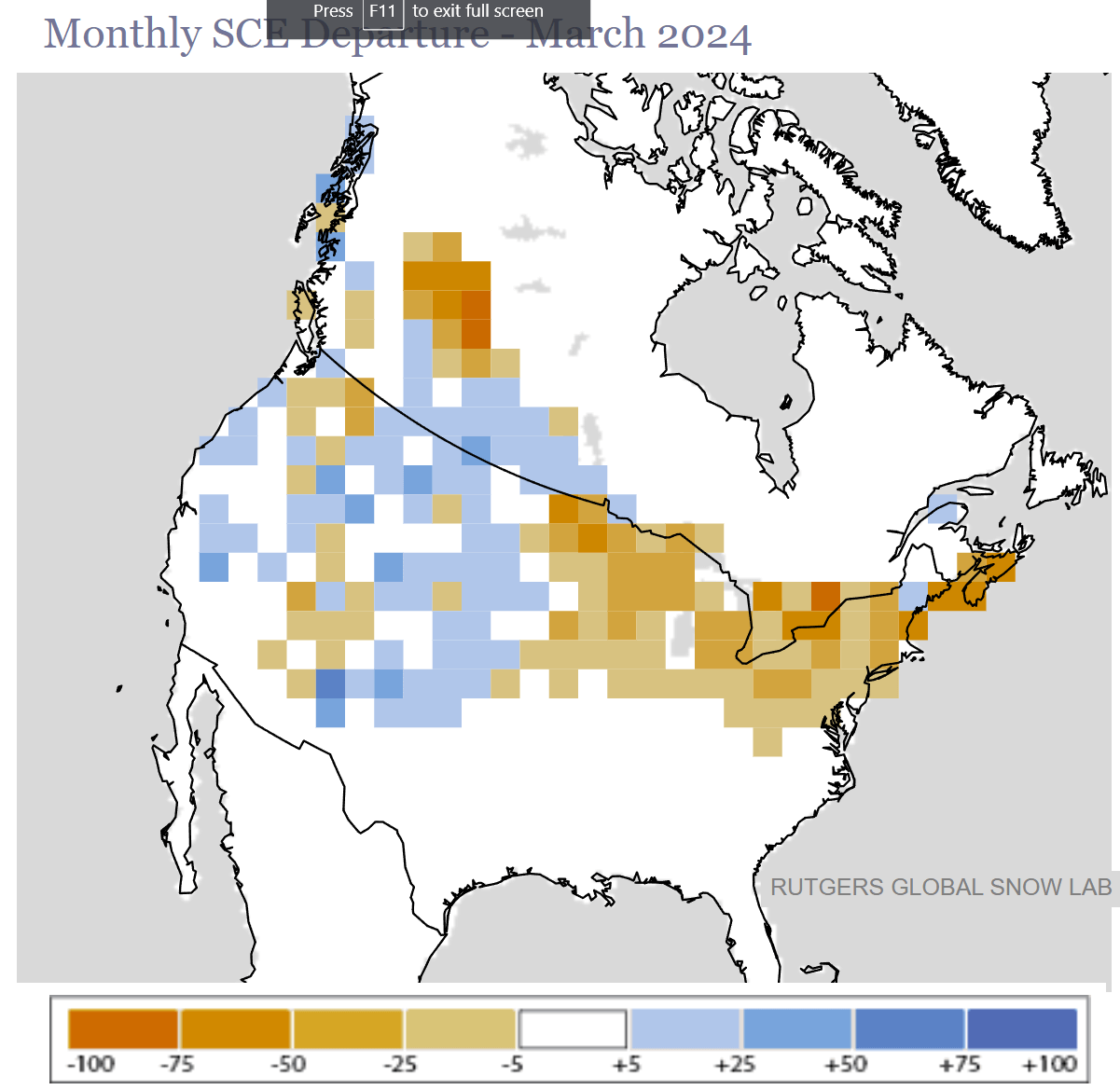
March was also the first spring month, which means that it is the transition period from winter, so snow events are still common. But looking at the snow analysis below from Rutgers, you can see that most of the Midwest and northeastern United States had less snow than usual for this month. Thanks to the low-pressure area, more snowfall was across the elevations of the western and central United States.
One of the drivers behind these patterns was the Polar Vortex, which we often talk about. In simple terms, it is just a name that describes the broad circulation over the northern (and southern) hemispheres during the cold half of the year.
The polar vortex extends high across different layers of the atmosphere. The lowest level is called the troposphere, where all weather events occur. But above that, we have the stratosphere, a deeper and drier layer.
Below is the early March analysis of the stratosphere at the 10mb level, which is at around 30km (18.5 miles) altitude. The polar vortex is shown as the low-pressure area (L). You can also see a strong stratospheric high-pressure area (H) that was stronger than the polar vortex and pushed it out of the north pole.

Combined with the warm wave that you can see inside the high-pressure area and around the Polar Vortex, this is called a Stratospheric Warming event.
Below, you can see the pressure anomalies in the atmosphere, from the ground up to around 50km (31miles) altitude. You can see this stratospheric warming event in early March, marked with the red box. It connected all the way down to the surface, but it did not fully connect with the lower-pressure systems for the rest of the month.
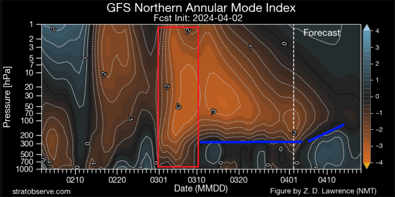
The blue line shows an apparent border between the strong high-pressure anomalies in the stratosphere and the lower levels. There was somewhat of a barrier that prevented the stronger impacts of the stratospheric warming from fully connecting with the lower levels.
You can see the dynamics of the Polar Vortex in the video below, which shows its structure in 3D. It shows a split event in 2016, which is a very good example of polar vortex dynamics and the connection to the lower levels.
In the forecast part of the last image above, you can see a low-pressure area evolving over the polar regions in the coming days. That will influence the weather further into the month, so we will look at the expected weather patterns in the coming days and weeks.
NEW MONTH BRINGS NEW WEATHER
Looking at the latest pressure anomaly forecast for the next few days, we can see a fairly disrupted weather pattern. A high-pressure area is over Canada and Greenland, which affects the positioning of low-pressure systems across the Northern Hemisphere.
Mainly, you can see four low-pressure zones. The most influential one in the coming days can be seen over the eastern United States.
Looking at the temperature forecast for Monday, we can see a cold temperature anomaly associated with a cold front passing across the eastern United States. Cooler temperatures are forecast across the Midwest and over the East. A cooler airmass is also forecast to enter the western United States under another low-pressure area.
Morning temperatures are expected to drop into the freezing levels across the upper Midwest and Mid-Atlantic. The rest of the eastern United States is expected to see temperatures in the mid to upper 30s. This is not an unusually cool event, but it is colder than normal for this time of year.

Looking at the surface pressure, we can see how the cooler airmass is being transported into the eastern United States and across the West. Low-pressure areas spin counter-clockwise, which means the eastern United States is under a northerly flow, as is the west coast of the United States.

Looking at the snow precipitation forecast for this period, you can see that snowfall is expected around the Great Lakes, in the upper Midwest, and across the Northeast. The snowfall pattern has a circular shape, which shows the effect of the low-pressure system. Image by AG Weather

Spring snowfall is also not uncommon across the northern United States in April, especially in blocked weather patterns over Canada.
WEATHER SYSTEMS AND AN ECLIPSE
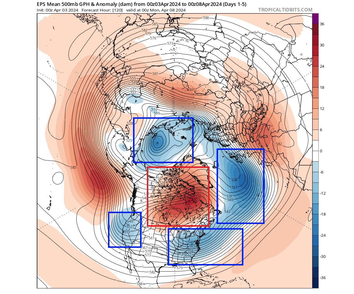
Looking at the pressure anomalies for next week, you can see a big change in the pattern. A broad low-pressure area is starting to take over the polar regions, with arms extending into the Pacific and the Atlantic.

These two arms help will help sustain a high-pressure ridge over the eastern and western United States. This will be an opposite weather pattern compared to this week, as high-pressure anomalies have replaced low-pressure systems.
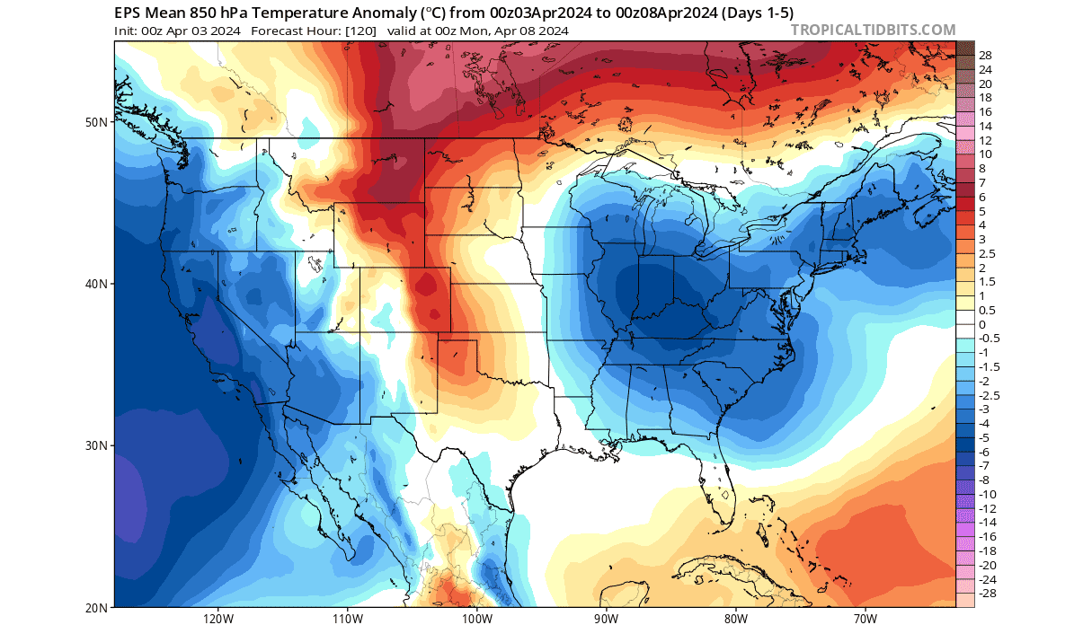
Looking at the temperature forecast for this period, warmer air is expanding back into the eastern United States as high pressure builds. A stronger warm anomaly is forecast under the remaining high pressure blocking over Canada.
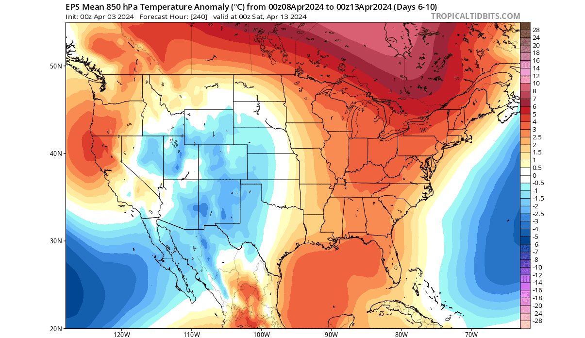
Below is the ensemble forecast for noon surface temperatures across the United States next Wednesday, and it shows warm temperatures climbing up over the eastern United States. The highs can be seen reaching into the 70s over the south and in the 60s all the way up to the Great Lakes and parts of the Northeast.

But, the underlying sea-level pressure anomaly shows the presence of a weak low-pressure area over the north/central United States, marked in the image below. This might not look that important on a first glance, but this is the day of the great total Solar eclipse across the United States.

This low-pressure area will have implications for cloud development over the central and eastern United States. Below is a cloud forecast for Monday noon, with the approximate totality path of the eclipse in red. Most of the path is affected by clouds, except parts of the Midwest and the far Northeast.

The cloud forecasts are among the most rapidly changing, so this is not the final outcome. But a lot depends on the positioning of that low-pressure area over the northern United States.
This eclipse will be a unique event, as the belt of the totality will pass from the southern United States up towards the Northeast. In total, more than half of the United States’s population lives within 250 miles of the totality path. Image by greatamericaneclipse.com

The image below shows how long it takes to drive into the path of the total solar eclipse. Over 3/4 of the United States population is within a few hours’ drive of the path of the total solar eclipse. So, as many people will take the road to see the total eclipse, weather will play a crucial role for both the travel and, of course, the visibility of the eclipse itself.

We are preparing a more in-depth article entirely dedicated to the total solar eclipse across the United States.
A WEATHER SLOWDOWN
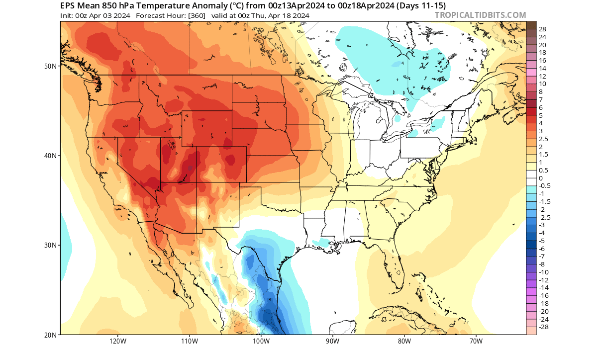
Going into the second half of April, the weather pattern over North America looks to stabilize and slow down. The high-pressure anomalies over Greenland and eastern Canada will be replaced by low-pressure, with the polar low area helping to build high-pressure systems over the mid-latitudes.

You can see a ridge building over the United States. It will help temporarily stabilize the weather pattern and bring warmer temperatures to most of the western and central parts of the country.
The airmass temperature anomaly shows a dome of warmer air under high pressure over the western and central United States, also extending to the southeast. A weak cool anomaly is over southeastern Canada due to a cyclonic area.
But looking at the surface temperature anomaly, we can see warmer temperatures spreading across the central and eastern United States. How is this possible, and which temperature map is correct? For the weather that we feel, the image below is more relevant, as it shows surface temperatures.

The surface temperature forecast below shows the spreading of warm temperatures across the plains and the eastern United States. From the high 70s to the near 60s far up to the upper Midwest and the northeast, this is the seasonal expansion of Spring weather.

Looking at the official precipitation outlook, most of the eastern half of the United States is forecast to receive more precipitation in the 8-14 day period. A drier week is expected over the western United States.

These forecast maps were provided by weathermodels.com, using a commercial forecaster license.
EXTENDED RANGE FORECAST
First, we have to add that the following forecast maps are just the latest trends. Despite the success these forecasts had in previous months, these are not fixed weather scenarios. Images are from weathermodels.com, using a commercial license.
Looking at the latest extended forecast, the weather pattern over North America looks to be stable in the last week of April. The high-pressure anomaly over the United States looks to persist, together with a ridge over Canada. Low-pressure areas are forecast in both oceans.

The temperature forecast shows the warmer airmass remaining across the central and eastern United States under the dome effect of the high-pressure zone.

The precipitation forecast shows less rainfall over the plains and the Midwest, as a stable high-pressure area limits the available moisture and dynamics needed for precipitation. More rainfall is forecast over the southern United States and up along the east coast.

As we approach the final week of April, the seasonal snowfall line also tends to rapidly shift north. Below is the snowfall forecast for the final week of April, where you can see that the high-pressure area will really push the snow line up into southern Canada.

Snowfall potential remains over the higher elevations of the western United States. There, the westerly and northwesterly flow still brings moisture and precipitation.
These forecast maps were provided by weathermodels.com, using a commercial forecaster license.
We will keep you updated on the global weather pattern development, so don’t forget to bookmark our page. Also, if you have seen this article in the Google App (Discover) feed, click the like button (♥) there to see more of our forecasts and our latest articles on weather and nature in general.
Learn more:
Summer 2024 Forecast: Early data shows the atmosphere in a shift from El Niño into La Niña