The Polar Vortex has just begun to form for the 2022/2023 weather season, but it is already facing its first disruptive event. Strong pressure systems in the lower atmosphere will send energy upwards into the Stratosphere, affecting the Polar Vortex and disrupting its early development process.
These early disruption processes can have an important effect as we get closer to Winter. Weather is linked to the stratospheric Polar Vortex, especially during the Winter. So it matters in what shape or form the Polar Vortex is as we enter the season.
But besides directly affecting the Polar Vortex, the pressure anomalies in the next days/weeks will also put another process in motion that can be even more disruptive for the Winter polar circulation. You will see how having more snow in October can mean more snow and cold in the Winter.

POLAR CIRCULATION, TOP TO BOTTOM
As we head into autumn, the polar regions start to cool as the Sun gets lower, and less energy reaches the area. But as the polar temperatures drop, the atmosphere further to the south is still relatively warm as it continues to receive light and energy from the Sun.
This causes a strong global pressure difference between the polar and sub-tropical regions, and a large low-pressure (cyclonic) circulation starts to develop across the Northern Hemisphere. It extends from the surface layer far up into the Stratosphere. This is known as the Polar Vortex.
We produced a 3-dimensional image of the Polar Vortex, extending from the lower levels into the Stratosphere. The vertical axis is greatly enhanced for better visual presentation. You can see what the actual structure of the Polar Vortex looks like.
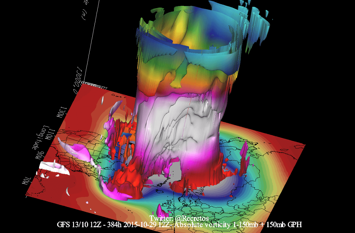
The upper (stratospheric) part is more circular and symmetrical as it spins higher above the ground. But the lower structure of the polar vortex is much more uneven and disrupted. That is due to the influence of the terrain/mountains and strong pressure systems acting as obstacles in the flow.
The image below shows the high-altitude Polar Vortex at around 30km/18.5miles in the middle Stratosphere during Winter. It is circular, with the temperature dropping quickly towards its inner core.
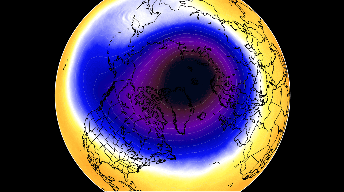
The stronger winds are typically found in the outer edge, also called “the surf zone”. Winds are very important when talking about the polar vortex, as they are usually the first to show that something in the polar vortex is changing.
In the next image below, we have the bottom of the polar vortex at around 5km/3miles. The closer to the ground, the more deformed the polar vortex gets because it has to interact with the mountains, overall terrain, and many pressure systems.
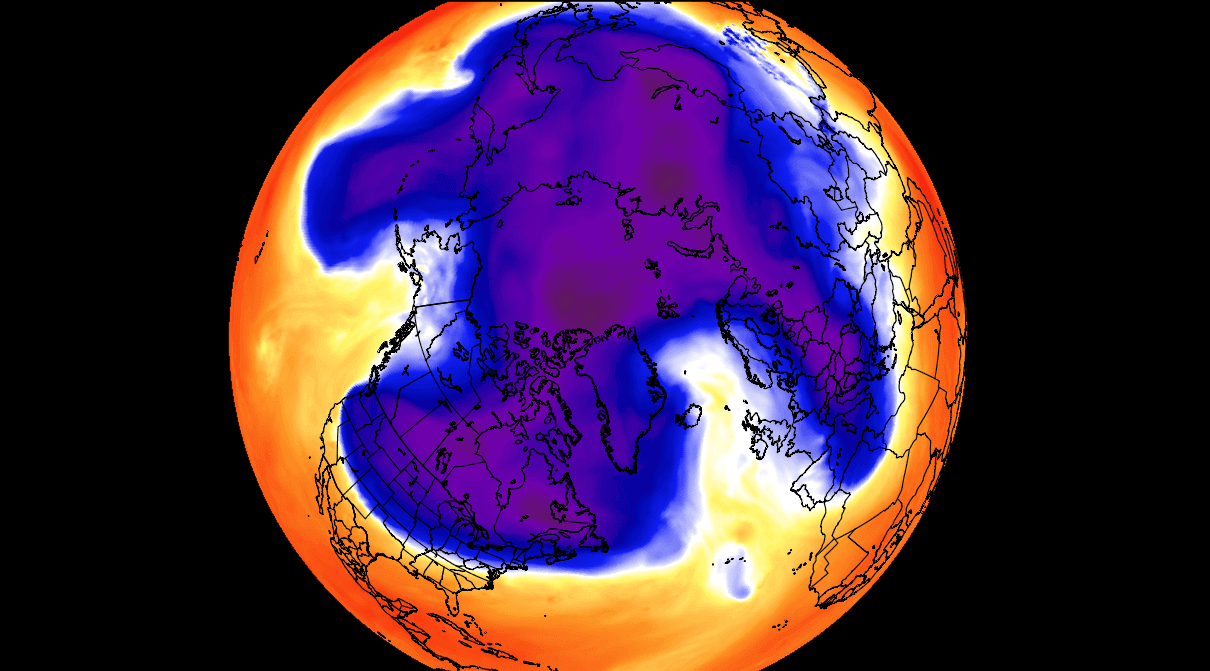
Notice the “arms” extending into the lower latitudes, bringing along colder air and snowfall. These arms also pack a lot of energy and can create strong winter storms, like a Noreaster’ in the United States or cold air outbreaks in Europe.
So to recap, the Polar Vortex behaves like a very large cyclone, covering the whole north pole, down to the mid-latitudes. It is connected through all atmospheric levels, from the ground up, but usually has different shapes at different altitudes.
So to summarize, we monitor any Polar Vortex activity because it can have weather implications across the Northern Hemisphere. And that is regardless if it is weak or strong.
A strong Polar Vortex usually means strong polar circulation. This usually locks the colder air into the Polar regions, creating milder conditions for most of the United States and Europe.
In contrast, a weak Polar Vortex can create a weak jet stream pattern. It has a more challenging time containing the cold air, which can now escape from the polar regions into the United States and/or Europe. Image by NOAA.

To put the Polar Vortex into perspective, we produced a high-resolution video below, showing the vortex spinning over the Northern Hemisphere in the Stratosphere at the 30mb level, around 23km/14miles altitude.
The main takeaway from the video should be that the Polar Vortex is not just one single winter storm or a cold outbreak that moves from the Midwest into the northeastern United States.
It is a large cyclonic area spinning over the entire Northern Hemisphere, from the ground up to the top of the Stratosphere and beyond, reaching over 50km/31miles in altitude.
WEATHER ABOVE AND BELOW
But even before we actually get to Winter, the activity around the Polar Vortex is still important, as it can have an effect in the long term. There are two ways the weather below in the lower levels can impact the Stratosphere above, even before the winter season begins.
First is the direct influence via strong pressure systems, having an impact upwards into the Stratosphere. Strong weather systems deflect energy upwards into the Stratosphere. That energy can deform the polar vortex, temporarily pausing its strengthening or even weakening its circulation.
In the image below, you can see the vertical wave activity example. First, the energy goes upwards into the Stratosphere, which impacts the polar vortex, which then affects the polar circulation back down, changing the weather patterns.
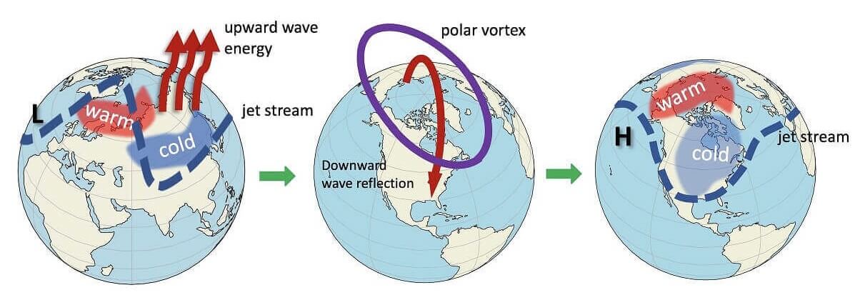
This example above is more appropriate for Winter when the pressure systems are strongest and much more energy is in the flow. As a result, the response downwards from the polar vortex is also amplified.
HIGH-PRESSURE BLOCKING BEGINS
This is kinda precisely what is forecast to happen in the coming days or weeks. A high-pressure mode is taking over the Northern Hemisphere for a while. It will, of course, impact the weather development going into October, but it will also press onto the Polar Vortex.
Looking at the 5-day pressure pattern forecast, you can see three ridging areas. These high-pressure systems can cut deep into the circulation, disrupting the main flow. But they have a slightly different effect in Fall than during Winter.
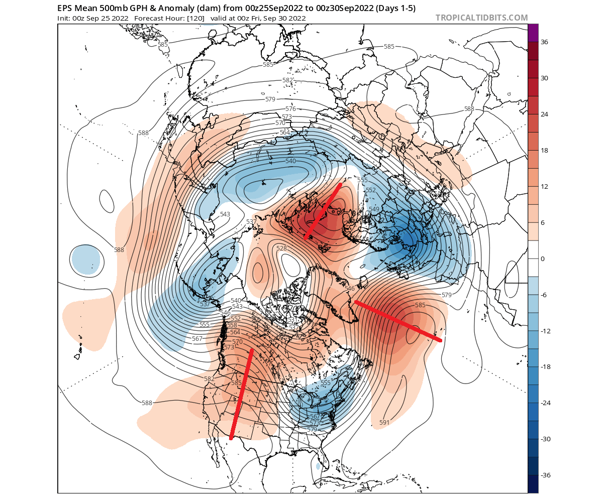
Notice the wave-like shapes going around the hemisphere. These are pairs of low and high-pressure systems that can send energy upwards into the Stratosphere when strong enough.
If you look at the temperature forecast, you can see that high-pressure systems bring mostly warmer than normal weather. But a low-pressure pairing over the United States will bring colder than normal weather into the eastern half of the United States.

Looking more closely at the United States below, the forecast image shows quite a significant cold anomaly over the eastern United States. The colder air is being transported thanks to the high-pressure ridge, which powers a northerly flow on its eastern side.

Finally, looking at the Polar Vortex at 10mb (30km/18.6miles), you can see that it looks normal for this time of year. It has a circular shape and a cold core, now undergoing cooling all the way into late December. Overall, no sign of any influence from below.

NEW MONTH, NEW WEATHER PATTERNS
As the new month begins, the high-pressure systems over the Northern Hemisphere will advance. The forecast image below shows two main high-pressure areas trying to connect across the north pole. During Winter, this might have enough power to create cross-polar ridging, which is a very potent cold winter pattern.
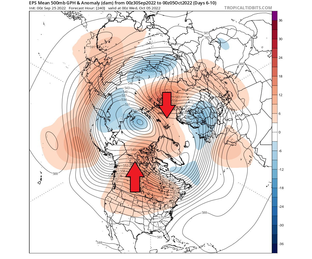
Together with the high-low wave in the North Pacific, this now has enough energy and a disruptive force to be felt in the Stratosphere.
You can see that in the stratospheric forecast below for early October. The Polar Vortex now has a more elongated shape and is being “pressed” by the emerging strato-high over the North Pacific. A temperature wave is also starting over Siberia.
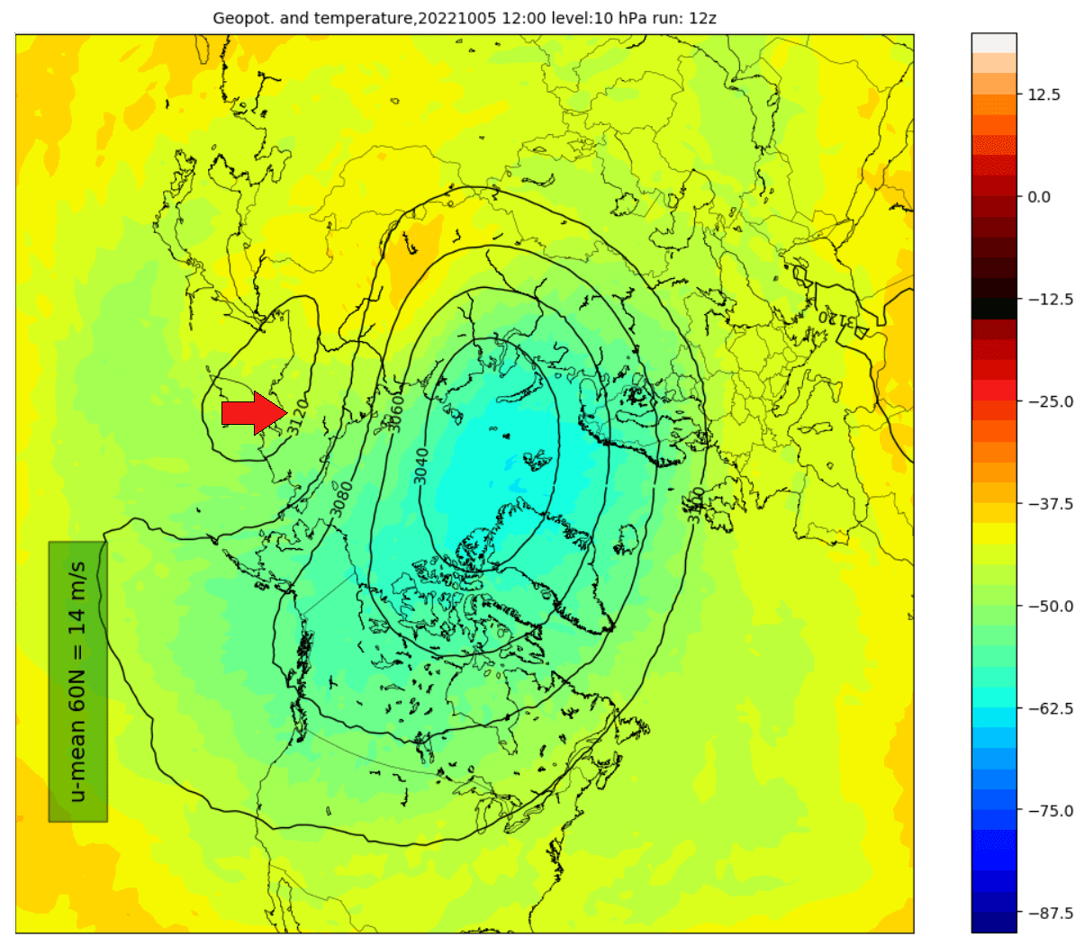
Looking at the temperature anomalies, we can better see the temperature wave developing over Siberia. Considering that this is in early October, it is quite remarkable. Such a pattern development during Winter could have widespread implications, perhaps even starting a proper Polar Vortex collapse event.

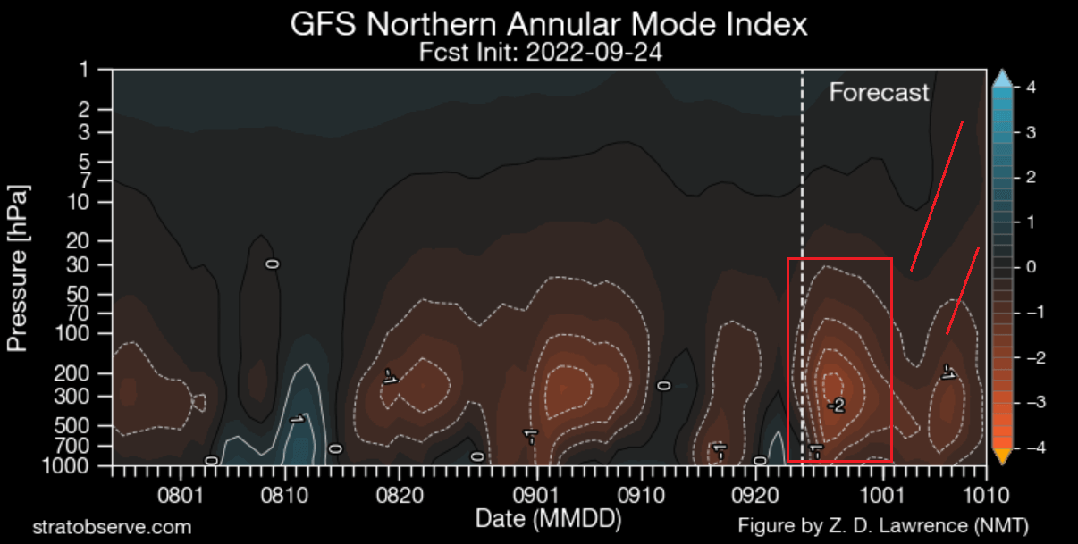
We can see the influence from below if we look at the vertical pressure anomaly forecast. You can see that in the next image, where the strong pressure anomalies are marked with a red box. This is because the anomalies already reach into the mid-stratosphere on their own.
Besides the actual anomalies, vertical wave activity is also being deflected upwards into the Stratosphere, helping to produce the warming wave. Combined, they put a lot of stress on the stratospheric Polar Vortex.
That is seen in the image below, which shows the ECMWF forecast of the stratospheric jet stream at 10mb (~30km). In the first half of the new month, you can see a very obvious weakening of the wind speeds in the mid-stratosphere.
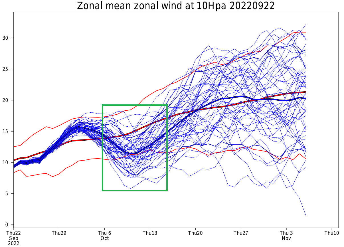
This is the forecast of the wind speeds produced by the Polar Vortex. We use winds to determine the actual strength of the polar circulation in the Stratosphere. So combining the pressure, temperature, and wind data, we can see how strong or severe a certain disruptive phase is.
PRESSURE INTENSIFIES
The mid-month forecast shows that three high-pressure systems still affect the lower circulation. The semi-persistent ridging over North America, the strong wave over North Pacific, and a new one in the North Atlantic.

The temperature anomalies for the same period nicely show the extent of the pattern disruption. Warm anomalies are expanding across the polar regions, pushing the cooler air out into east Asia and parts of Europe. The ridging over the United States is central and strong, not permitting any stronger colder air anomalies.

The stronger the pattern, the more energy gets pushed upwards into the Stratosphere. You can see that in the Polar Vortex forecast below for the same period. Now being pressed from both the North Pacific and the North Atlantic, the Polar Vortex has a very elongated shape, not typically for this time of year.

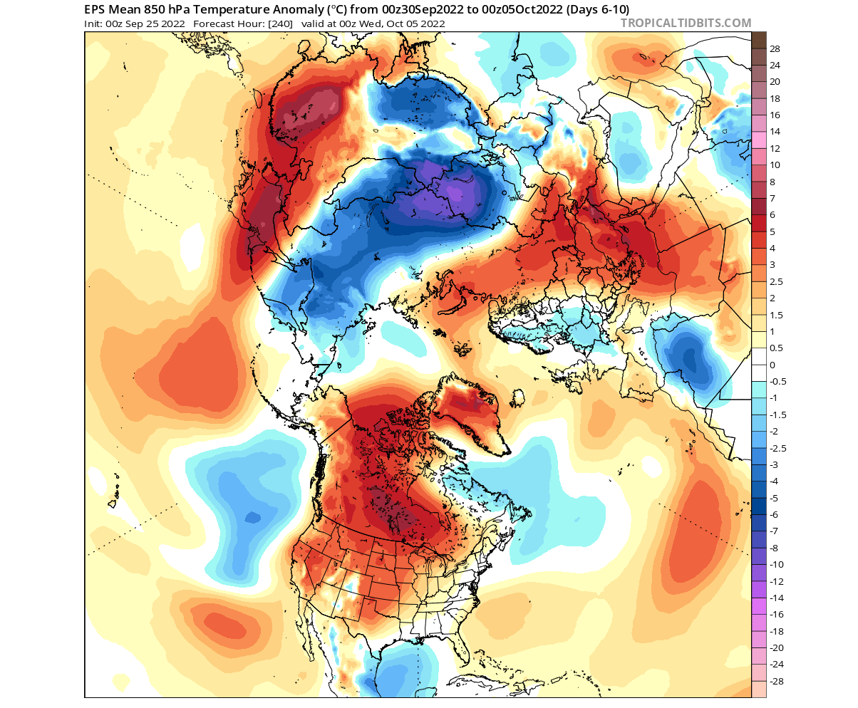
You can see a warming wave continuing, also nicely seen in the temperature anomaly forecast below. The temperatures are expected to rise over 15 degrees above normal, which is quite substantial for the first half of October. Image by weatheriscool.

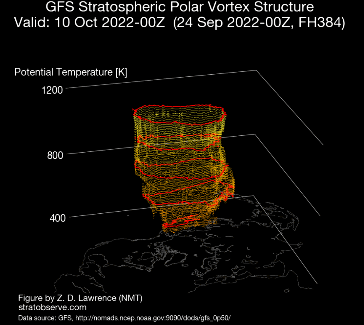
All this activity will leave a mark on the Polar Vortex. You can see in the 3D structure below that the Polar Vortex has a very elongated/oval shape. It is currently in the build-up phase until early Winter, so any major disruptions can sometimes have a long-lasting effect, limiting its potential later in the season.
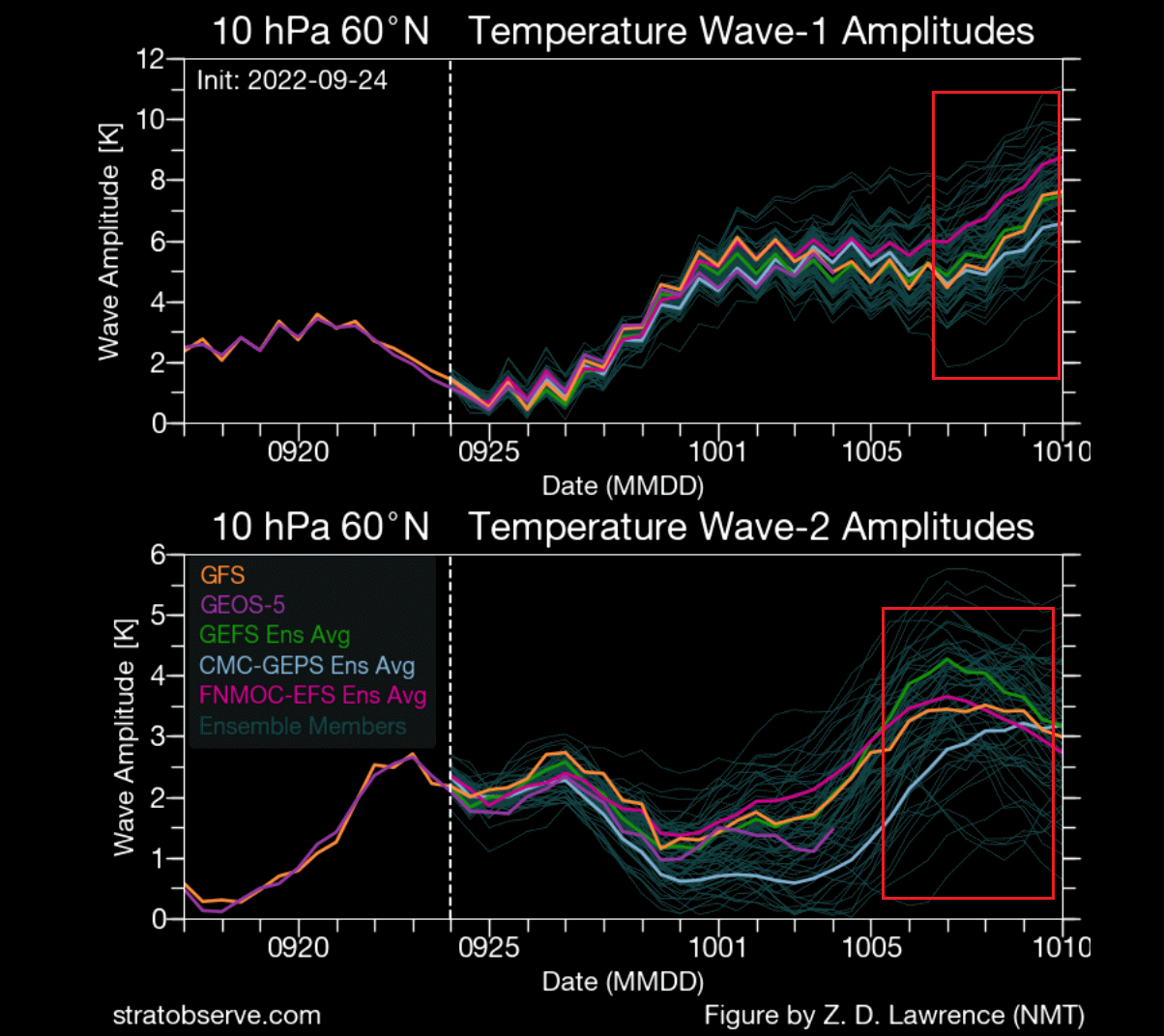
We can track these disruptions as waves in the Stratosphere. Below we have the pressure wave forecast for the mid-stratosphere. You can see the increasing pressure waves in the first half of October, which is what we looked at above.

We can also track temperature waves. As you can see below, we have a forecasted increase in temperature waves resulting from vertical energy transport due to the strong high-pressure systems in the lower levels of the atmosphere.
Of course, what does this mean for the weather development down the line? As mentioned before, the Polar Vortex should ideally strengthen from now until late December.
With such disruptions in the way, the strengthening process of the Polar Vortex can be limited or delayed. This means that a weaker Polar Vortex will enter the Winter season, which can mean a very different weather outcome compared to a strong polar circulation from the ground up into the Stratosphere.
But there is one more way that Fall weather patterns can have another impact on the Winter Polar Vortex and thus on the cold outbreaks or snowfall patterns over the United States and/or Europe.
SNOW COVER FROM OCTOBER TO WINTER
The second way the Fall weather can influence the Polar Vortex is by building an extensive snow cover over Siberia. Multiple studies have proved that the snow cover extent in October over Siberia has an effect on the weakening of the stratospheric polar vortex.
A stronger winter high-pressure system can develop over the region due to snow cover. The high-pressure area affects the polar vortex, as it helps to send more vertical energy up into the Stratosphere. A weaker polar vortex naturally means weaker polar circulation and a greater chance of cold air outbreaks over the United States and Europe during Winter.

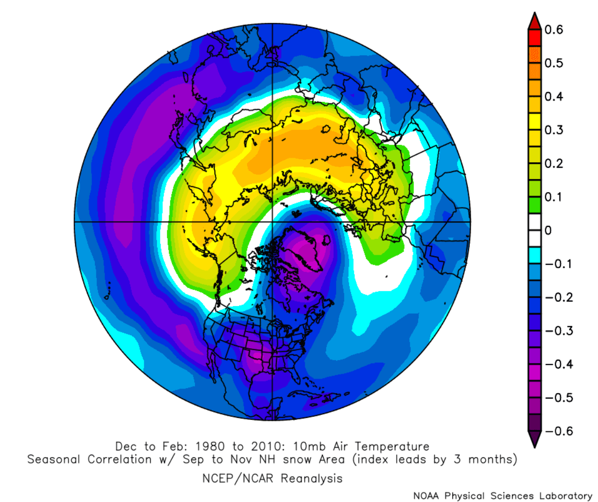
We produced an image that shows the connection between Fall snow cover and Winter pressure anomalies. As you can see, a higher North Hemispheric snow cover in Fall is linked with higher pressure over the polar regions in Winter.

This shows a weak polar circulation, meaning that colder air has an easier path out of the arctic circle and down towards the United States and Europe.
But looking at the same linkage with the temperature in the Stratosphere, we can see a signal for warming waves around the Polar Vortex. It means a weaker stratospheric Polar Vortex and a more disrupted weather pattern below.
Currently, we are already seeing more snowfall than usual over Siberia. The graph below shows the snow cover extent over Eurasia already above the normal levels, with more to come.

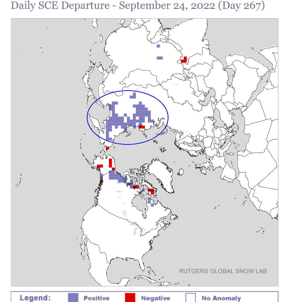
The image below shows the snow cover analysis, revealing the current snow extent across the Northern Hemisphere. A large batch is already present over Siberia, earlier than normal.

We can see that if we look at Rutgers‘s great snow cover analysis, showing the snow cover anomaly over the Northern Hemisphere. There is a large anomalous area of increased snow cover over Siberia, also seen in the analysis above.
But what about the forecast? Looking below at the 10-day snowfall forecast, we can see a substantial increase in snow cover. Blue colors indicate snowfall and snow depth increase. All areas from North America to Siberia will increase snow cover.

This is due to the pressure changes that we mentioned earlier. In addition, as you can see on the temperature forecast below, a large batch of cold air is being released into Siberia. That is helping to create more snowfall and increase the snow cover.
The 10-16 day snowfall forecast continues this trend, further increasing the snow cover over North America. While we can see some melt in the lower parts of east Asia, we can see an otherwise further increase in snow cover both towards west Siberia and towards the east.

POLAR VORTEX AND WEATHER SUMMARY
To summarize everything, there are two main things to take away from this development. First, strong high-pressure systems will impact the Polar Vortex more directly. Pressing upwards and sending energy waves, we are seeing a reduction in the power of the Polar Vortex.
The Polar Vortex should be increasing strength steadily from now towards at least early Winter. However, these intermediate disruptions can delay that strengthening process, meaning that the Polar Vortex can arrive weaker into the Winter than it would otherwise.
Another secondary effect of these pressure patterns is the increased snow cover extent over Siberia. As data shows, increased October snow cover over Siberia leads to a stronger high-pressure system over the region.
That high-pressure system helps to send more vertical energy into the Stratosphere during Winter. So that is yet another potential blow for the Polar Vortex in the long term.
But why is the strength of the stratospheric Polar Vortex important in Winter?
If the Polar Vortex enters Winter in a weaker state, it is more susceptible to a full collapse event. As pressure systems get stronger and more energy goes upwards into the Stratosphere, it can reach a point where the Polar Vortex can completely collapse.
That is called a Sudden Stratospheric Warming event and basically means a strong warming event of the Stratosphere and a following collapse of the Polar Vortex.
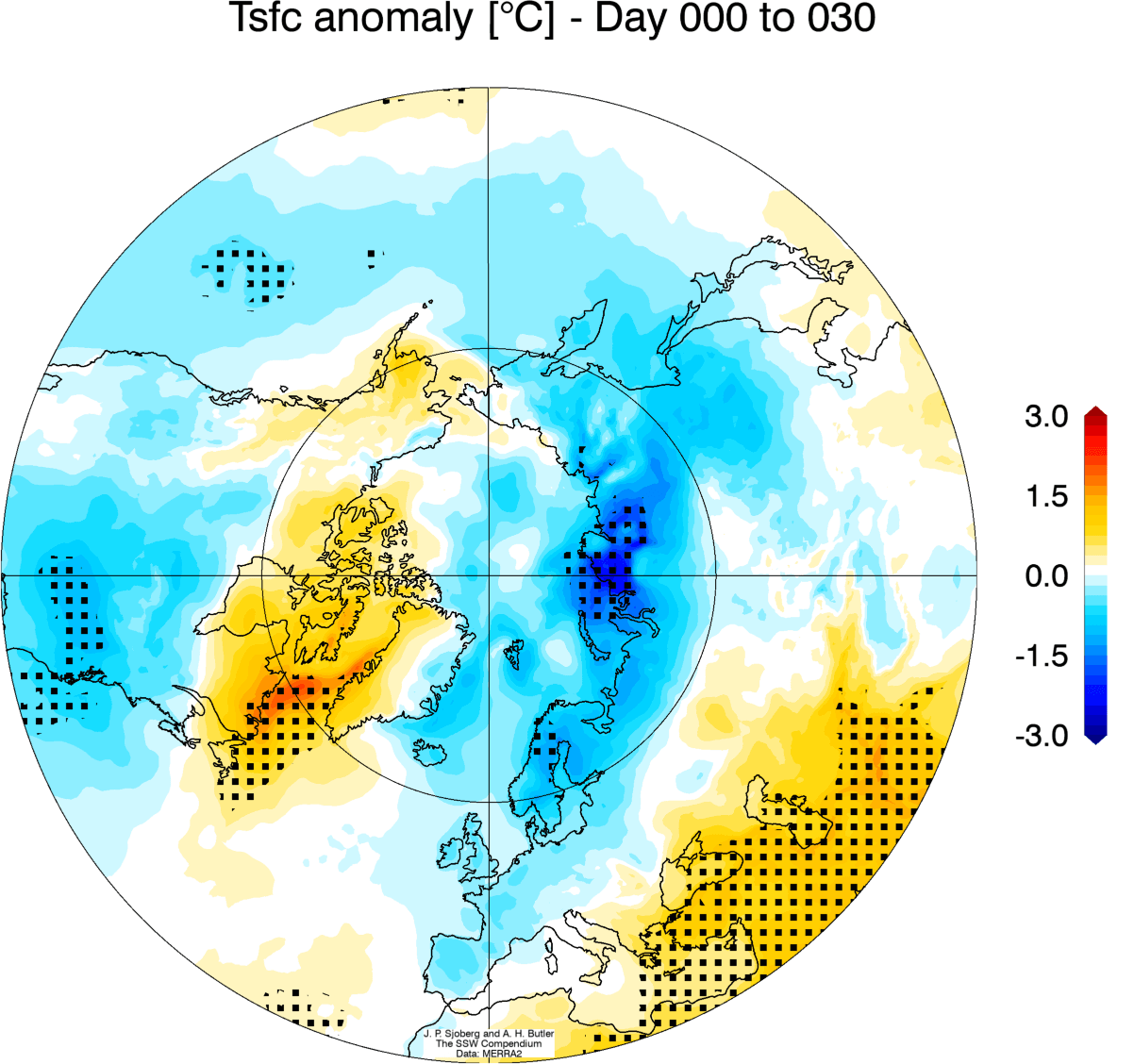
The corresponding average temperature 0-30 days after an SSW event shows that most of the United States is typically colder than normal, along with Europe. Note: this is an average picture of many SSW events. Each individual stratospheric warming event is different and does not automatically mean a strong winter pattern.
Looking at snowfall, we can see above-average snowfall over much of the eastern United States and also Europe. Again, this is an expected response, as typically, after major stratospheric warming, the colder air has an easier path towards the south and into these regions.

So as you can see, having a strong or weak Polar Vortex can significantly change Winter weather over the United States, Canada, and Europe. For this reason, we closely monitor the weather patterns and all activity surrounding the Polar Vortex.
We will keep you updated on the global weather pattern development for the coming seasons, so make sure to bookmark our page. Also, if you have seen this article in the Google App (Discover) feed, click the like button (♥) there to see more of our forecasts and our latest articles on weather and nature in general.
Don’t miss: