A particularly dangerous weather situation is unfolding across western Europe this week, as the very active Polar Vortex aloft has led to a dramatic response of the North Atlantic weather pattern. Through Wednesday night, a widespread windstorm Dudley is expected to cross the UK and push destructive winds with the potential for tornadoes towards northern Germany. Then, a violent winter storm Eunice will blast across the UK with snow and strong gales on Friday. Winds could locally be in excess of 100 mph!
IMPORTANT UPDATE: Severe Weather Forecast for Europe – STORM EUNICE on February 18th, 2022
After a relatively quiet period and lacking winter weather across Europe and the North Atlantic lately, the weather pattern has finally flipped. After the strong Polar Vortex activity across North America, its southern lobe has activated the Atlantic troughs that are now heading for a dangerous impact on western Europe.

This Wednesday, we can see how the pattern development is well underway across the North Atlantic and the western half of Europe. The Arctic cold blast arriving from Canada and the Labrador Sea is spreading into the Northwest Atlantic, with a wave disturbance seen by the cloud pattern on its front edge.
Ahead of this wave (front), the much warmer air mass is making its advection far towards the north across southwestern into western Europe, spreading across Benelux, UK, and Germany as well. Marked on the chart are the potential tracks of both storms, Dudley tonight and the Eunice on Friday.
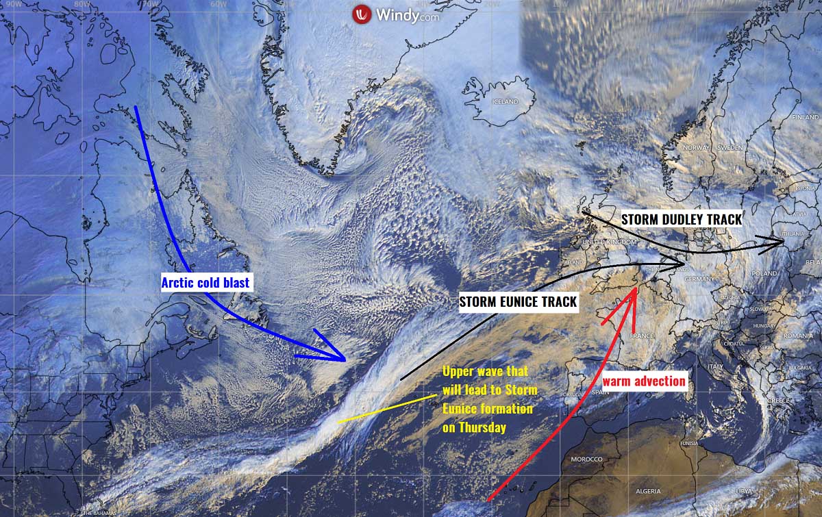
Through Wednesday night, a severe windstorm Dudley is forecast to bring violent winds across the UK first, then spread towards Benelux and Germany by Thursday morning. A severe weather threat could also include tornadoes as the cold front clashes with a weakly unstable airmass ahead of it. A fast-moving frontal line of storms with damaging winds is well possible.
The system will gradually vanish on Thursday while moving into Poland but our eyes have to immediately focus on the next, potentially more intense and damaging windstorm Eunice that will blast across the southern UK and Benelux on Friday. It will bring violent winds to nearly 100 mph, with a decent amount of snow possible across parts of Wales and central England.
The swath of both of these storms is pretty wide and long, roughly from the Atlantic coast of Ireland and Scotland to the northern half of Germany, southern Poland, and Czechia. Expect power outages and traffic disruptions where the most intense winds will develop. And also quite some good snow amounts across Ireland, Northern Ireland, and parts of the UK through Friday evening.
As mentioned earlier, the main driving factor behind these violent windstorms in the forecast is the pretty active Polar Vortex above us this Winter season 2021/22. It has really been unusually intense this year and is showing no signs of weakening or even collapsing due to an SSW event anytime soon. Before we dig into the weather situation deeper, let’s first find out how the Polar Vortex works and why is it important for our daily weather.
THE IMPORTANCE OF THE POLAR VORTEX
Once we look at how our atmosphere is built, it really shows us that things are pretty well connected and correlated. Rounding our planet, there are six layers, the most of the weather dynamics for our daily weather happen in the lowest two layers. Those are known as the troposphere and the stratosphere layers.
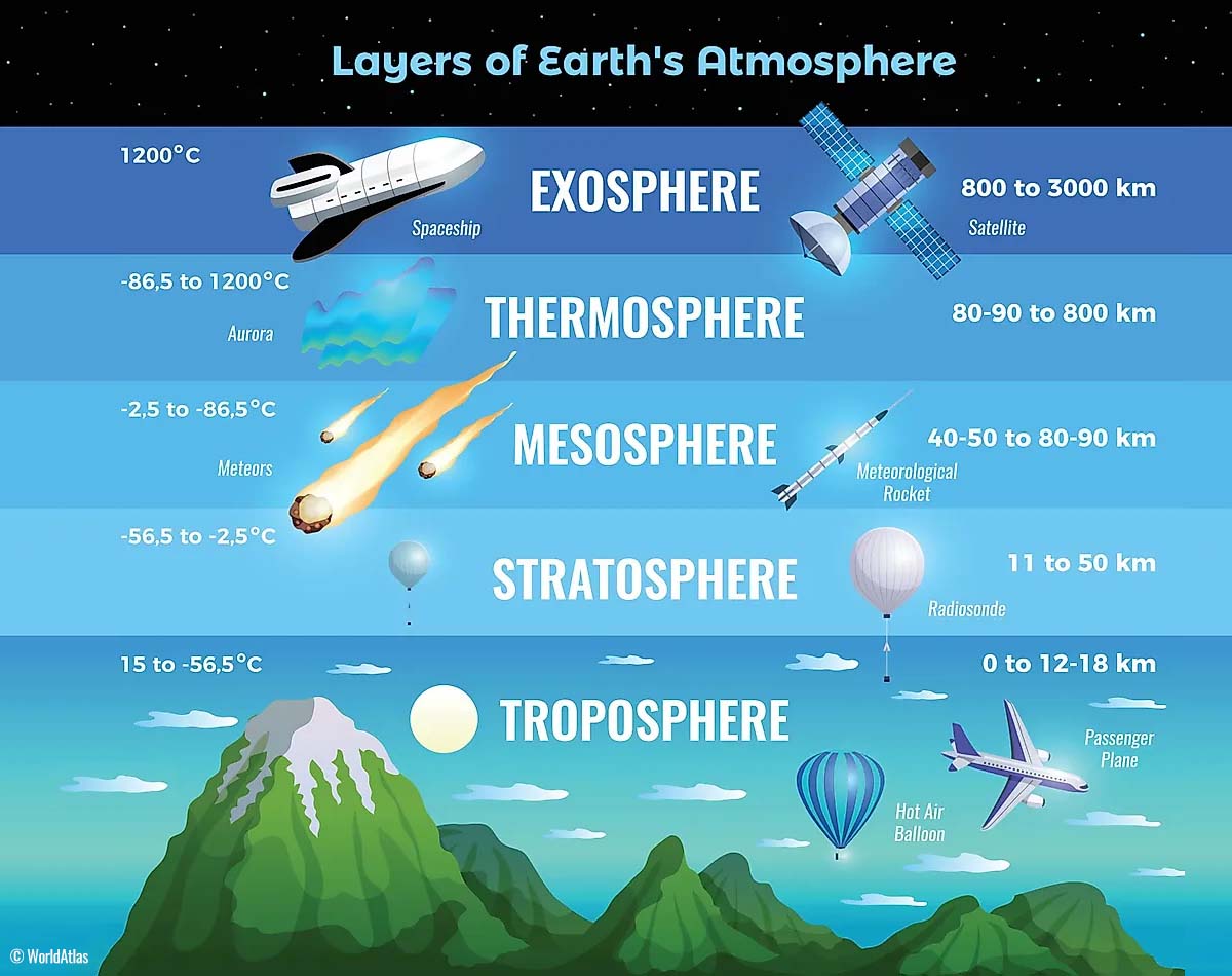
The lowest layer is known as the troposphere, it extends from the surface (or the sea level) up to about 12 km up in the sky. It has a variable depth that is between 8 km to almost 20 km. Its thickness depends on where you live, the troposphere is the deepest above the equator, and it gets much thicker above the North and South poles.
The next layer above the troposphere is a much deeper one, it is the stratosphere layer. The stratosphere is about 10-50 km thick and is also a very dry layer. This layer also has one important part, which is the Ozone layer which has a vital role in the protection of our planet’s life.

While the most important part in the stratosphere layer, that actually triggers all the weather dynamics, is known as the Polar Vortex. The Polar Vortex is an enormous, 3D (three-dimensional) ring of very powerful winds above us. It surrounds both the North and South poles, racing across the sky about 20-50 km above the Earth’s surface.
The Polar Vortex is the strongest during the winter months on both the Northern and the Southern hemispheres, this strongly affects the winter weather from October through March every year.
So, in general, the troposphere and the stratosphere layers are very crucial for Earth’s climate. The Polar Vortex is basically covering most of the bottom half of the atmosphere, extending roughly from the middle of Earth’s troposphere higher up into the stratosphere layer.
This is why it has an important role in the winter weather pattern across the high and mid-latitudes for all the continents, North America, Europe, and Asia. And we have to study its behavior to properly understand the consequences and its potential effects on the upcoming weather systems.
Formation of the Polar Vortex
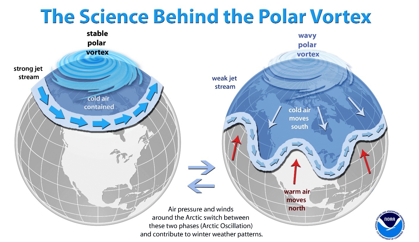
When we are in the early autumn months, the polar regions across the northern hemisphere are starting to receive less and less sunlight over time. This happens because of the stronger inclination of the Earth’s axis, the North Pole is therefore sent into the position that it starts cooling down. As a result, polar nights also occur, days without any sunlight following.
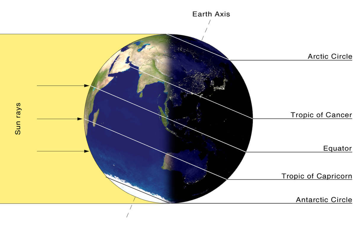
While the polar regions are getting colder and colder as we head into the winter months, the atmosphere towards the equatorial regions to the south is still relatively warm compared to the polar regions. So those regions continue to receive much more sunlight and energy from the Sun compared to the regions farther north, thus creating a higher temperature contrast between them.
With the poles getting cooler, it is also translating into lowering the surface pressure there. A pretty similar weather process also happens in the stratosphere layer above it, therefore, the temperature gradient between the North pole and the equatorial areas increases. Thus, it leads to the development of a large low-pressure cyclonic circulation across the polar stratosphere. Hence, this is where the naming of the Polar Vortex comes from.

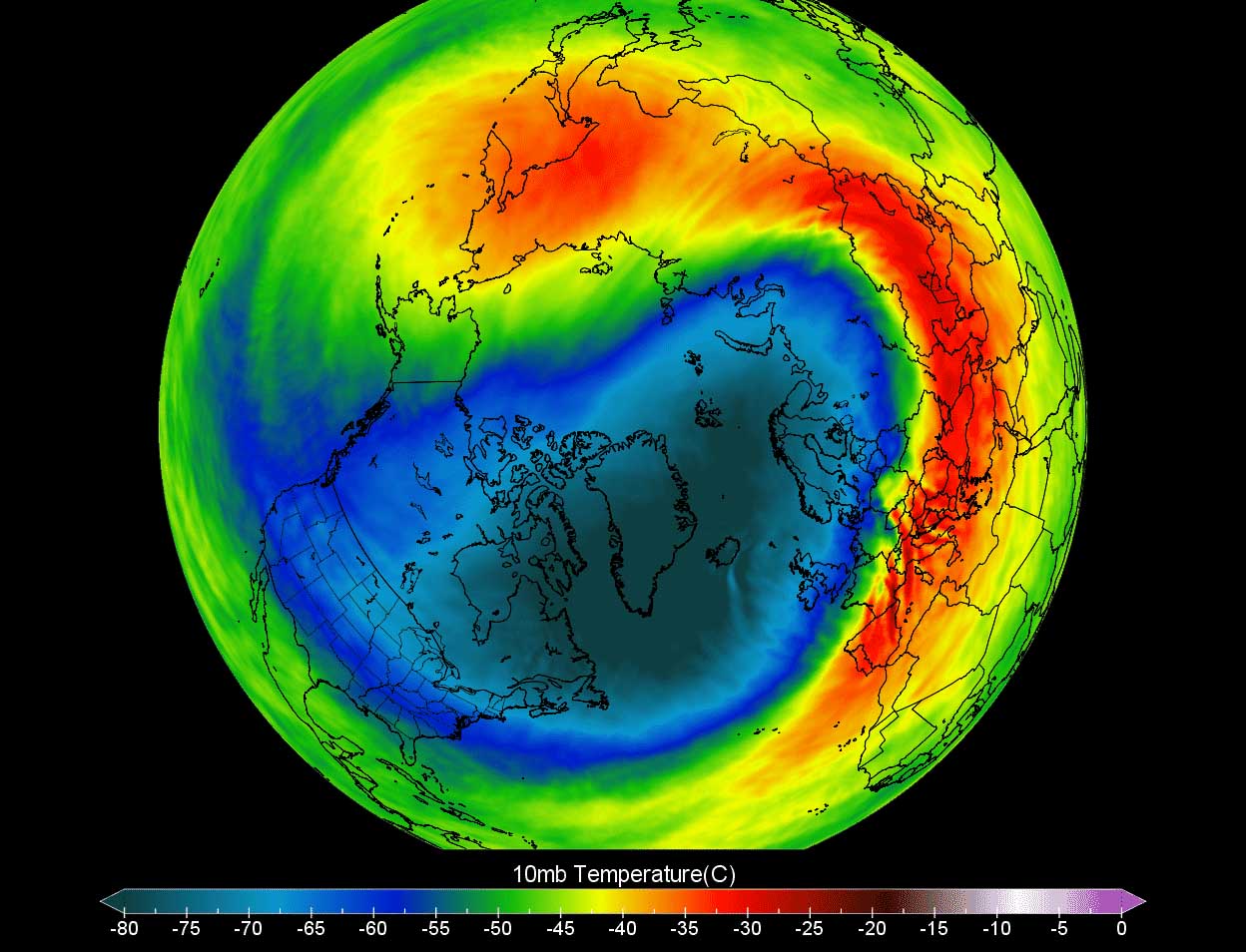
The Polar Vortex is acting as a very large cyclone, it covers the whole North Pole region, and spread down to the regions into the mid-latitudes as well. So it works as one large hemispheric circulation within the bottom part of the Earth’s atmosphere. The stratospheric pressure chart above hints us the textbook example of the Polar Vortex established above us. Located at around 30 km (18 miles) altitude, very near the top of the stratosphere during the winter season.
Compared to the previous years, the Winter Season 2021/22 has the Polar Vortex very strong and unusually active. While Europe has been actually lacking any intense cold outbreaks so far, the southern lobe of the Polar Vortex was the main trigger behind the frigid Arctic outbreak and significant winter storms blasting across Canada and the United States in the recent weeks.

Finally this week, a major weather pattern shift across the Northern Hemisphere is now underway, meaning effects will also be major across the North Atlantic and Europe.
The chart below hints us a huge contrast between the air mass from north to south, with a large and deep upper trough over the Atlantic and northern Europe, with a powerful upper High across the south.
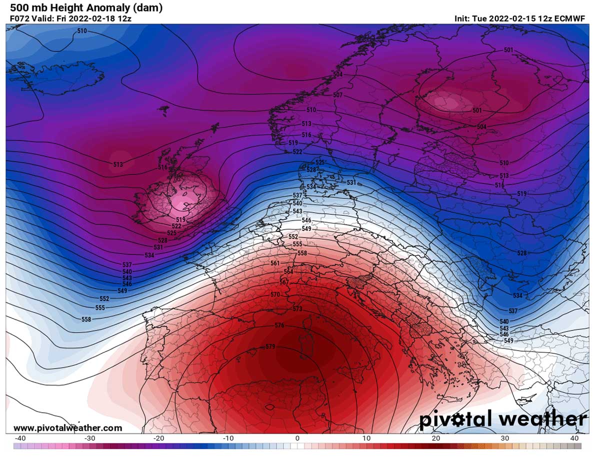
The new deep upper-level wave disturbance will be moving roughly from west to east, from western towards northern Europe with the violent westerly jet stream in between these large scale features. The deep trough will lead to a powerful windstorm Dudley from the UK to Germany tonight first, followed by another intense winter storm Eunice for the UK and Benelux on Friday.
A VIOLENT WINDSTORM DUDLEY BRINGS DANGEROUS WEATHER FROM UK TO GERMANY WEDNESDAY NIGHT
A particularly dangerous weather situation begins deteriorating towards the night as the pressure gradient strengthens with the surface depression crossing the northern UK. The frontal system will cross the North Sea with a well-defined cold frontal boundary racing towards Benelux and northern Germany tonight.
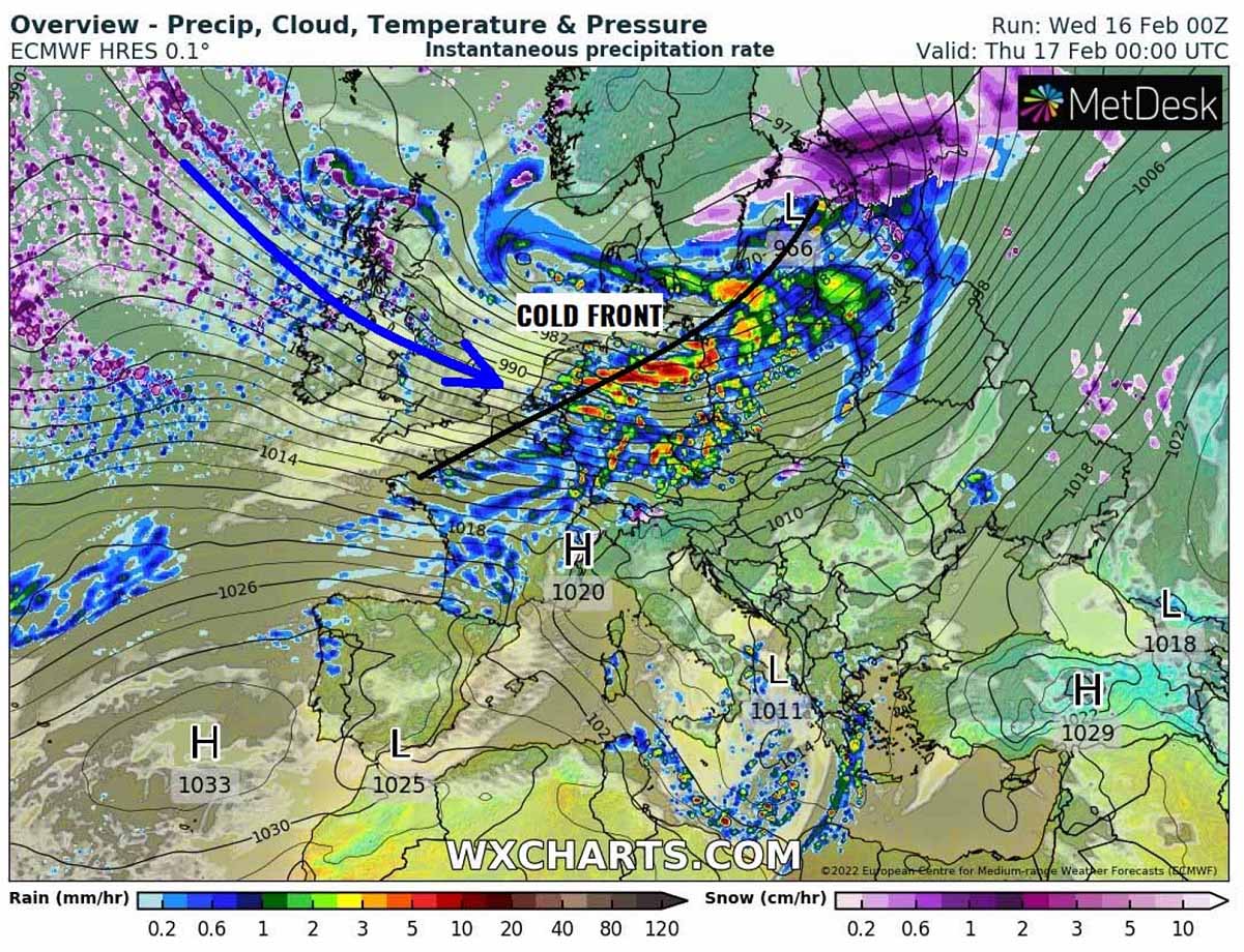
With some hundreds of J/kg of CAPE (convectively available potential energy) available ahead of the front in northern Germany, the racing front will likely be forming convective storms. They should quickly become severe, given the very strong winds present in the lowest levels, thus strong wind shear.
The next attached chart below is showing the swath of the severe winds through Thursday morning, with numerous tracks of single convective cells with gusts well above 100 km/h. Those are occurring with the storms along the eastward racing leading front.
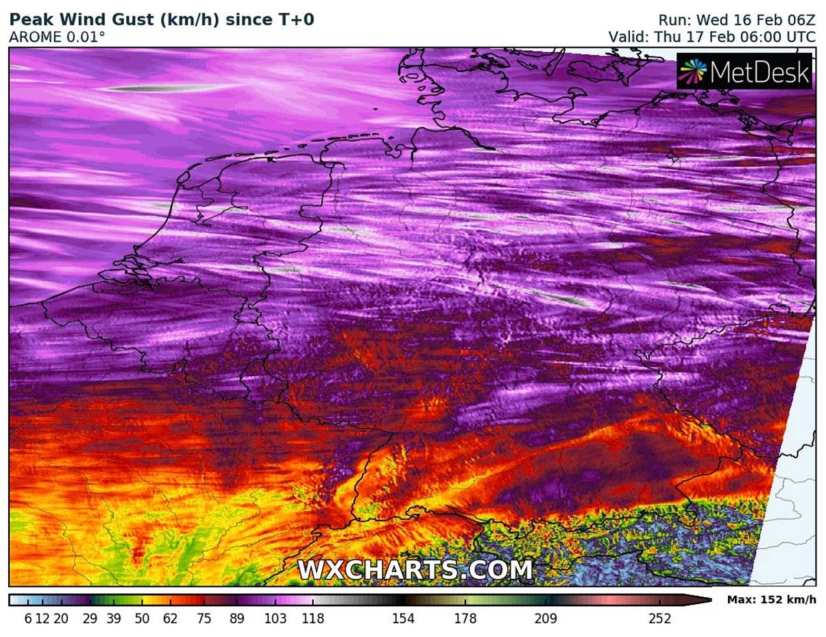
So it is very likely that widespread severe to locally extremely severe (gusts above 120 km/h) could result along the frontal storms. It is more likely that the most severe winds will develop across the Netherlands and northern Germany than the UK with Dudley, where at least some shallow instability is forecast by the weather models.
Note, that a combination of both the strong shear and weak instability is known as violent windstorms in the wintertime from the past. An example of this is the windstorm Kyrill at the end of January 2007. Shallow convective cells lead to extreme wind gusts, often coming from both the rain squalls or even tornadoes.

It could happen again tonight, with a few tornadic storms well possible. Even a strong tornado is not ruled out from northeast Germany to western Poland where the best overlap of shallow instability and the strongest wind shear/helicity in the lowest levels is present.
POLAR VORTEX MAKES A STRONG COLD PUSH OVER THE ATLANTIC, FORMING STORM EUNICE FOR THE UK ON FRIDAY
The first storm Dudley will be leaving east quite fast on Thursday, while the North Atlantic will enter the even more active mode. Thanks to the southern lobe of the Polar Vortex emerging from Canada into the far portions of the Atlantic, a plume of significantly colder air mass will be advancing deep south.

This will trigger another surface low to the north of Azores, beginning to rapidly deepen its central pressure towards Thursday night as it shifts farther northeast. This will be our next potentially damaging windstorm, Eunice. As we can see from the chart above, a huge contrast of much warmer subtropical air mass against the Arctic cold develops.
The warm air mass will overspread southwestern Europe, nosing towards Ireland and the UK, followed by a much colder air in the wake of the developing storm Eunice. Between the strong Azoric high on the south and deep Icelandic low, the strong westerly jet stream will help the low to head for a more east-northeast trajectory.
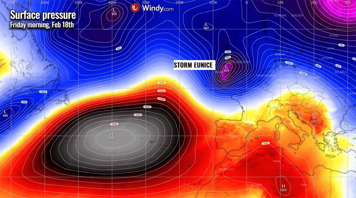
Storm Eunice should deepen considerably through Friday morning, possibly reaching near 975 mbar while moving across the northern part of the Bay of Biscay towards southwestern England and Wales. How far north the trajectory of Eunice will travel is still a bit undefined, but it is forecast the center of the low will travel in the corridor between southern Ireland and the English Channel on Friday morning.
It will continue east during the day and afternoon hours, bringing intense winter storm weather across Ireland, Wales, and England. Attached below is the 24-hour sequence of storm Eunice traveling from the Bay of Biscay on Thursday evening across the UK into the North Sea by Friday evening.

As we can see, the ECMWF weather model is hinting at some pretty rough weather, with heavy rain and severe wind squalls to the south of the center low. In the northern side of the comma cloud, heavy snow with near-blizzard conditions is pretty much expected.
These effects will strongly depend on the storm’s track, therefore the amounts of snow/rain will vary according to the cyclone’s trajectory.
STORM EUNICE LIKELY TO BLAST UK, THE ENGLISH CHANNEL, BENELUX AND NORTHERN GERMANY WITH VIOLENT WINDS
Such a deep low, possibly below 970 mbar, should no doubt lead to some pretty violent winds in places, especially to the south-southwest of the center low where the strongest pressure gradient will develop. The highest wind gusts could reach well above 80 mph, possibly even close to 100 mph (160 km/h) locally. From southwestern England across the English Channel to the Belgium and Netherlands coast in particular.
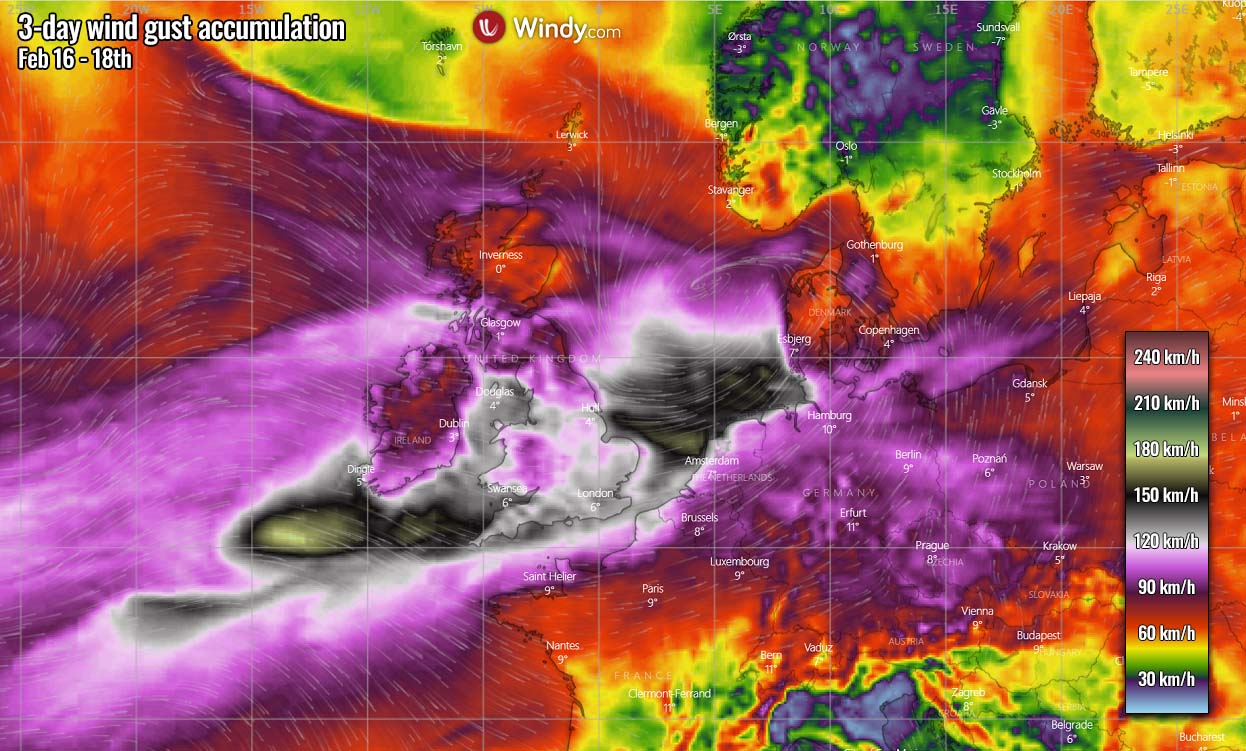
Don’t take the exact areas with the highest gusts as the final, as just a small shift of 50-100 km of Eunice’s center to the north or south will make a difference where the most intense winds will occur. Nevertheless, severe to extremely severe wind gusts are expected across a wide area as seen above.
The amounts of rain will not be too particularly high, however, the classic rainfall sums near the higher terrain due to orographic precipitation are expected. Those include western portions of Ireland and Northern Ireland, Wales, western and northern England, and western-central Scotland. These areas should receive about 40-80 mm of rain through Saturday morning.
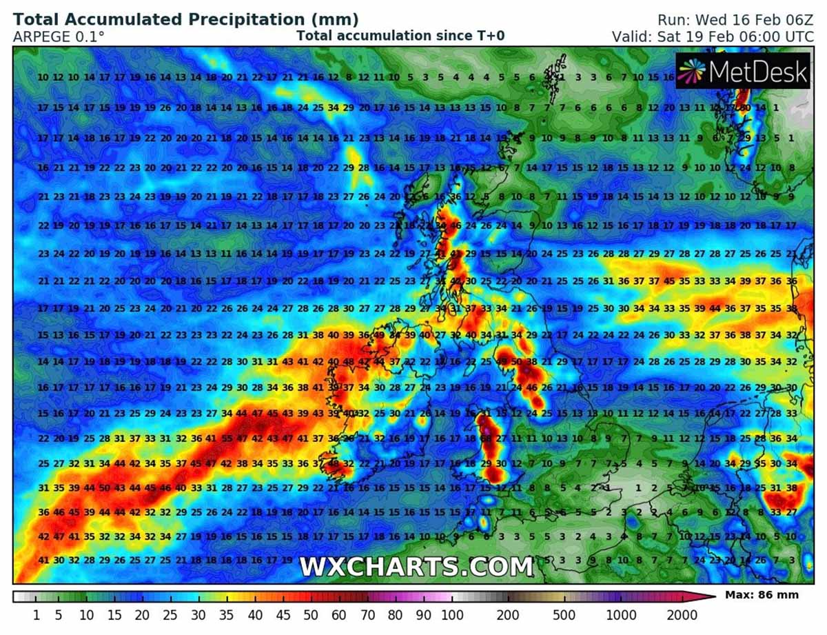
On the northern side of the traveling Eunice, snowfall is forecast to occur and will likely be heavy at times. With a combination of strong to severe winds, near-blizzard conditions are possible, despite the snowfall being of a wet phase. Snow accumulations could be from 5-20 cm in some areas.
Farther north, into Scotland, snow will be rather dry due to much colder air mass in the rear side of the surface cyclone, so expect higher snowfall sums compared to the areas across the southern UK. Possibly 30-50 cm of fresh snow across the Scottish Highlands, up to 20 cm in the western lowlands.
