It has been just two weeks ago when wild winter weather blasted across a large part of the North American continent, the next system is already shaping up for mid this week. Thanks to the Polar Vortex being so intense this winter, the next Winter Storm will spread across more than two-thousand miles from the Southern Great Plains to the Northeast U.S. and Atlantic Canada. A huge battle of Arctic cold and tropical air mass will lead to major snowstorm from Midwest to the Great Lakes, with potentially significant severe weather with tornadoes across the southern and Southeast United States.
The Mid and late winter months are often periods when the most intense cold outbreaks and snowstorms develop across the North American continent. Thanks to a large plume of strong Arctic cold air mass from Canada into the United States, again particularly dangerous ingredients will be in place.
A major Winter Storm is expected to bring new snow and dangerous icy conditions extending along a more than 2000 miles long track from the southern Great Plains to New England and southeast Canada this week. Travel disruptions and flight delays are likely to be expected across the nation from Wednesday through Friday.

At the end of January, the most intense system of the season – winter storm Landon buried parts of the east-central U.S. into deep snow, while ice storm brought havoc to its immediate south. This week, similar winter weather conditions are forecast to repeat again.
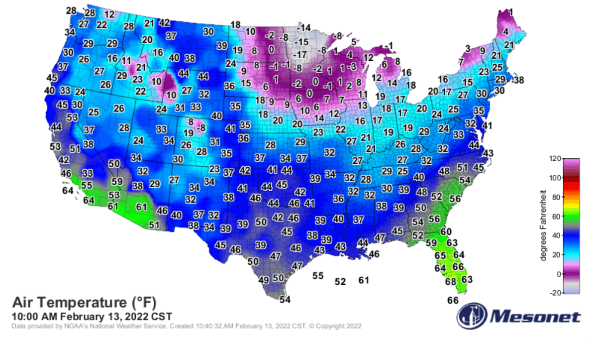
It has become quite cold again this past weekend, especially across the Upper Midwest with temperatures below -10 °F during Sunday afternoon in parts of Minnesota. The coldest air remains across the Northeast, the Great Lakes, Ohio Valley, and New England. Temperatures are now warming up quite a lot prior to the arrival of the front across the South and East Coast.
The swath of this new storm with significant impact will stretch across more than 2000 miles from Texas to Maine, with winter weather conditions expected. A major snowstorm, dangerous freezing rain, and ice storm are increasingly likely to bring significant travel delays, flight cancellations, and road closures for tens of millions along its path.
The general weather pattern will begin worsening on Wednesday with the arrival of a strong upper wave and another cold outbreak from Canada towards the south. It will trigger a large winter storm across the central U.S., gradually moving towards the northeast through Friday, reaching Atlantic Canada on Saturday.
Another concern with this winter storm is also several hundred miles swaths of severe weather potential across the central and Southeast U.S. Dangerous severe storms with tornadoes and damaging winds are becoming increasingly likely.
The main driving factor behind the upcoming winter storm that will affect more than two-thousand miles swath is the Polar Vortex above us. It has been unusually intense and active this winter season 2021/22 and is showing no signs of weakening or collapsing anytime soon. Let’s first find out how it works and why is it important for our weather.
THE IMPORTANCE OF THE POLAR VORTEX
Once we think about how our atmosphere is built, it really enlightens us on how things are connected and correlated. Around the Earth, there are six layers and most of the weather dynamics for the life on our planet happen in the lowest two layers. They are known as the troposphere and the stratosphere layers, the other four are higher as can be seen below.
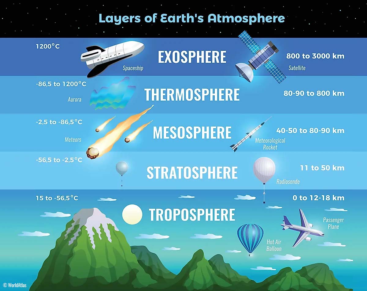
The lowest is the troposphere layer, the one where all the weather we encounter takes place. It expands from the surface (from the sea level) up to 12 km above our heads. It has a depth that varies between 8 km to almost 20 km, and its thickness depends on where you live. The troposphere layer is the deepest above the equator, and it gets much thicker above the North and South poles.
The following layer above the troposphere is a much deeper one, we know it as the stratosphere. The stratosphere layer is around 10-50 km deep and is a very dry layer. An important part of this layer is also the Ozone layer which has a vital role in the protection of our planet’s life.

But the most important part in the stratosphere, that actually drives the dynamics in our weather, is known as the Polar Vortex. This is an enormous, 3D ring of very powerful winds above us. The Polar Vortex surrounds both the North and South poles and is rotating about 20-50 km above the surface of the Earth.
The Polar Vortex becomes the strongest during the winter months on both hemispheres.
In general, both the troposphere and the stratosphere layers are very crucial for our planet’s climate. The Polar Vortex basically covers most of the bottom half of the atmosphere, extending from the middle of Earth’s troposphere higher up into the stratosphere layer.
And it has an important role in the winter weather across the high and mid-latitudes for all the continents, North America, Europe, and Asia.
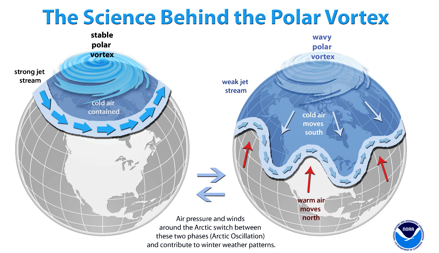
So, although the Polar Vortex spins very high up above our heads, it remains directly connected with the lower part of the atmosphere. Thus, the Polar Vortex drives our daily weather and gives it shape most of the time. It works as one large hemispheric circulation within the bottom part of the atmosphere.
Formation of the Polar Vortex
In the autumn months, the polar regions across the northern hemisphere receive less and less sunlight over time. This happens due to the stronger inclination of the Earth’s axis as the North Pole is sent into the position that it starts cooling down. As a result, polar nights without any sunlight also occur there.

Meanwhile, the polar regions are getting cooler with time, the atmosphere layer towards the equator to the south is still pretty warm. It still continues to receive much more sunlight and energy from the Sun compared to polar regions farther north, thus creating a higher temperature contrast.
The colder temperatures spreading across the polar region also translate into lowering the surface pressure. While a pretty similar process also happens in the stratosphere layer above it. Therefore, the temperature gradient between the North pole and the equatorial areas increases, leading to a development of a large low-pressure cyclonic circulation across the polar stratosphere. Hence the name Polar Vortex.
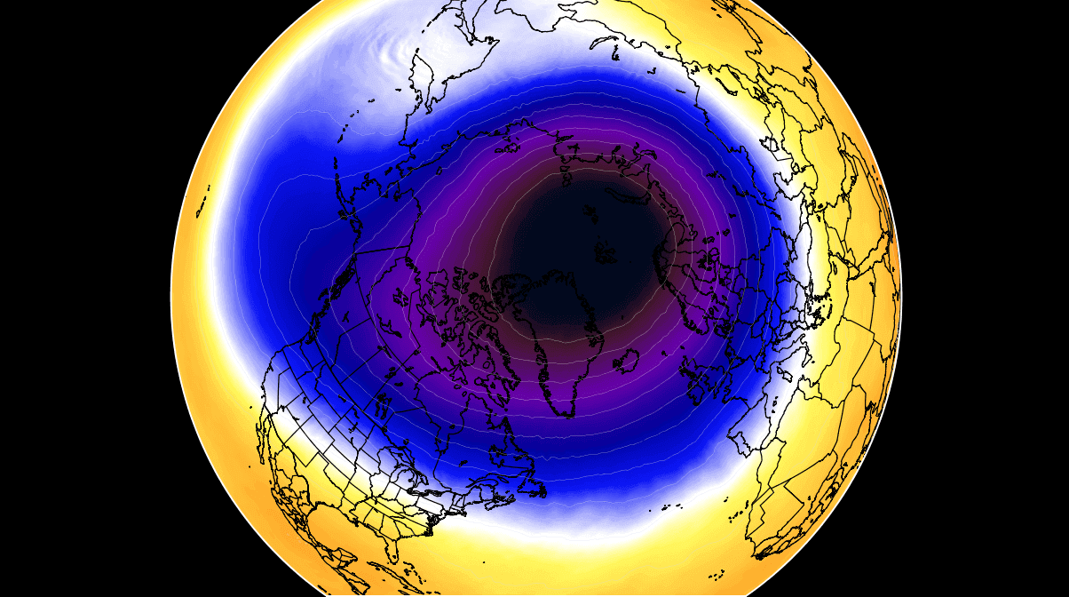
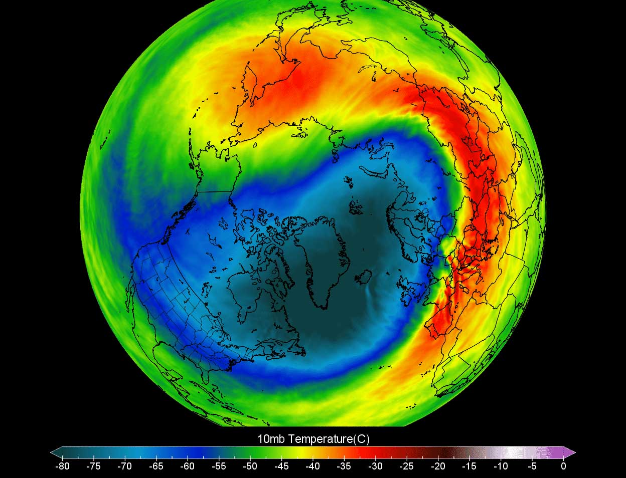
The Polar Vortex is therefore acting as a very large cyclone and it covers the whole North Pole, spread down to the regions into the mid-latitudes as well. The same also happens in the southern hemisphere winter period. The attached chart above is showing us the textbook example of the Polar Vortex established above us. It is located at around 30 km (18 miles) altitude, near the top of the stratosphere during the winter season.
During the Winter Season 2021/22, the Polar Vortex aloft is very strong and unusually active. It was the main trigger behind the frigid cold, Arctic outbreak, and significant winter storms blasting across Canada and the United States. The upcoming next major winter storm that will cover more than 2-thousand miles is led by the activity of the Polar Vortex.

The new deep upper-level wave disturbance will be moving across most of the U.S., locked in between two strong blocking highs on each side. The system will lead to the development of a major snowstorm and ice storm across the central and northeastern parts of the country, followed by another strong Arctic cold outbreak towards the south in its wake.
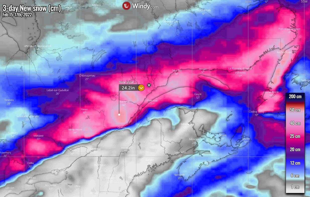
Quite some new snow, including sleet and freezing rain, is forecast from Oklahoma to the Great Lakes and further into the Northeast U.S. and Atlantic Canada after mid-week.
POLAR VORTEX TRIGGERS A NEW WINTER STORM WITH 2000 MILES SWATH
The Winter storm begins as the surface low deepens during Wednesday night, with snow, sleet, and freezing rain expected to become more widespread from the central Plains into parts of the Midwest. Thursday will bring further wild winter weather in these areas, with the snow potential becoming very heavy in some areas, extending across the Great Lakes.

Farther south of the winter front, heavy rain will develop across the huge warm sector ahead of the deepening surface low. The contrast between the much colder air behind the low and moist and warm to its front, will also significantly increase the wind field. Leading to a strong moisture return and unstable air from the tropical region and the Gulf of Mexico into the central U.S., and the Ohio Valley and the Southeast in particular.
As we can see from the charts above, representing the system evolution from Thursday morning through Friday morning, a wide swath of significant winter storms will develop. From the heavy snow in one side to severe storms on the other, a narrow corridor of freezing rain will develop in the middle.
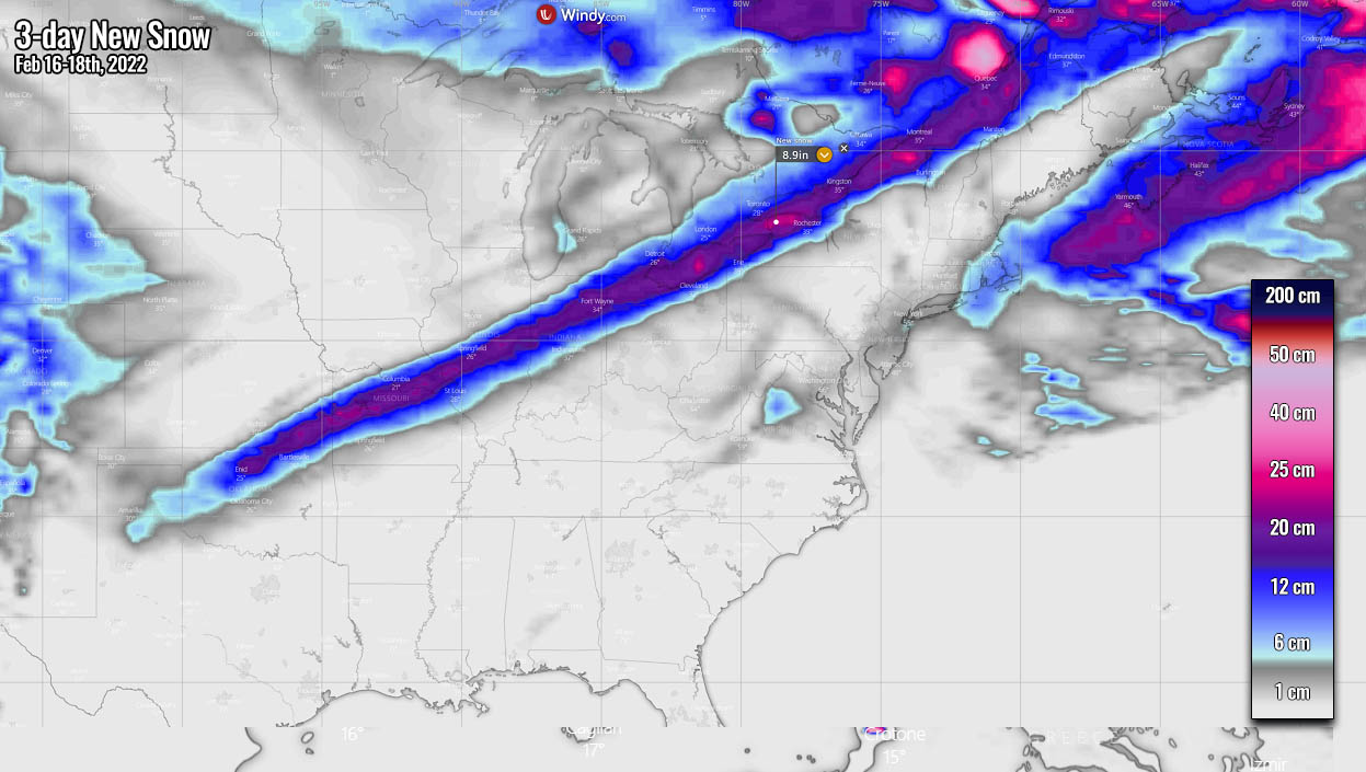
The potential for heavy snow accumulations is very high from the Central Plains into the Midwest and northern New England. Those areas also include major cities, Kansas City, Chicago, Grand Rapids in the U.S., and a large part of southern Ontario, Canada.
From eastern Kansas to southern Michigan, up to a foot of snow is forecast, much more farther northeast into Canada. Potentially even 15-20 inches (2 feet) in some areas according to weather model forecasts for this new 2000-mile-long swath of the snowstorm this week.
Some fresh snow accumulations are also forecast for portions of Colorado, Wyoming and Montana, locally 5-10 inches will be possible across the Rockies. Conditions will be pretty cold as northerly winds will be blowing snow, reducing visibility and disrupting travels.
With the progress of the winter storm farther northeast on Thursday, temperatures are forecast to plummet and become more than 20 degrees F colder than normal across the central Plains and Midwest.
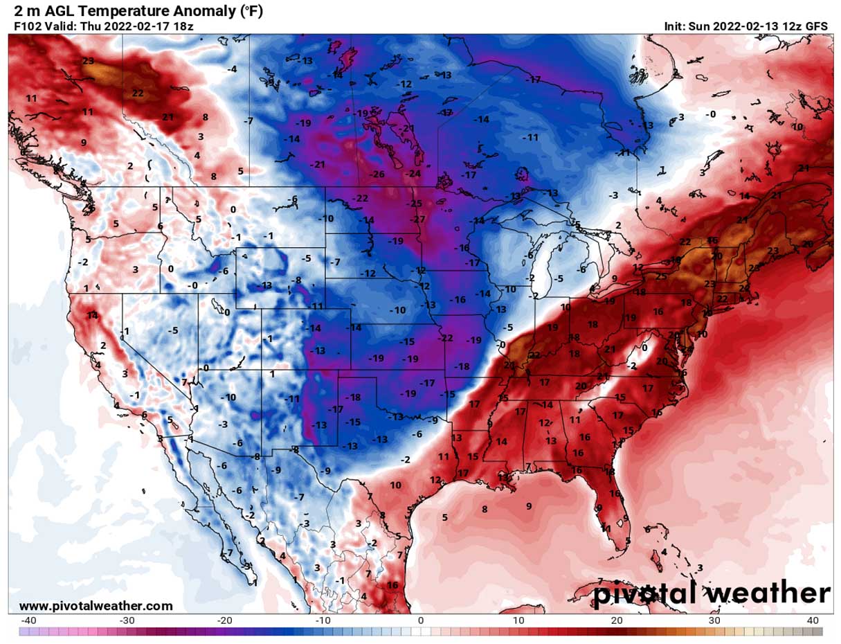
Ahead of the Arctic front, significantly warmer weather is forecast to take place. Strong southerlies will advect high moisture and temperatures across the eastern half of the country, with temperatures being more than 20 °F above normal in mid-February. Especially across the Ohio Valley, the Mid-Atlantic, and New England.
ANOTHER ICE STORM FOR THE MIDWEST
Areas from the southern Plains across the Mississippi Valley to Ohio Valley and nearly up to the coast of the Atlantic Canada are also in the threat of a dangerous ice storm event on Wednesday and Thursday. The system will be ejecting off the Rockies into the central portions of the country and significantly strengthening towards the Midwest.
A typical response of this is that it brings much warmer air mass towards the north while freezing temperatures are battling it in the lowest level closer to the ground.
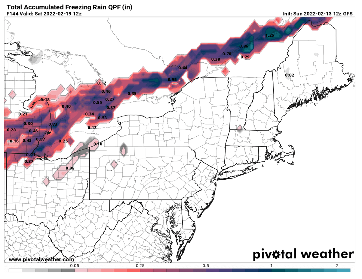
What appears increasingly likely with each weather model forecast recently is that the swath of the freezing rain potential is pretty large. Placed roughly along the southern fringe of the massive snowstorm to the north we’ve seen above. The amounts of ice accumulations are concerning in some areas, as often it leads to catastrophic tree and power lines damage.
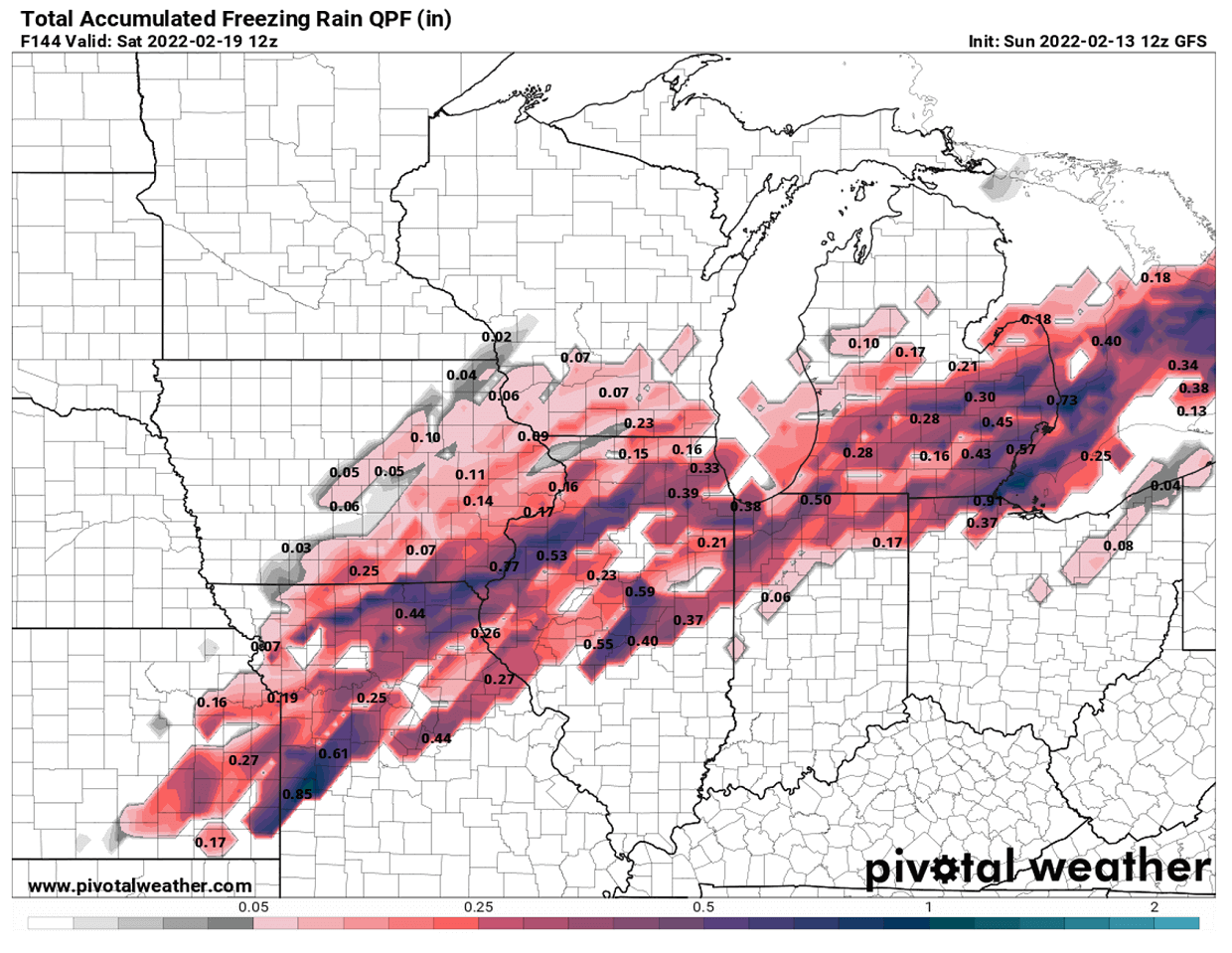
The winter precipitation is forecast to begin across the Panhandles on early Wednesday as the low deepens off the Rocky Mountains, gradually intensifying and increasing in coverage across northern Texas and southern Oklahoma into Arkansas through Wednesday. The ice storm extends further across the mid-Mississippi Valley and Ohio Valley through Thursday.
While it will be very heavy snow to the north of the Arctic cold front associated with the system, freezing rain is a very likely scenario to the south of it. The return of much warmer air mass from the south is actually pretty significant, leading to strong thermal inversion against the cold from the north. The thermal inversion means the temperature in the lowest levels is much colder than those layers immediately above.
The total amount of freezing rain (ice) forecast through Friday night is particularly high from eastern Kansas across northern Missouri and Illinois to Michigan, farther northeast across southern and eastern Ontario. The amounts of ice could locally be damaging and significantly impact travel. Portions of the Great Lakes could be facing 0.5-1″ (1-3 cm) of freezing rain and therefore ice accumulation, causing black ice.
Black ice is a term we use when the ice has developed (accumulated) on the surface of a roadway. It is mainly transparent but takes on the color of the surface of the road it is on. Once the ice gets wet from the outside temperatures warming up, it becomes dangerously slick and it has led to numerous deadly road accidents around the world in the past.
With very cold temperatures present near the surface and the freezing cold ground, the ice should accumulate and result in an ice thickness. The highest ice accumulations in this ice storm event are expected from Wednesday night through Thursday evening, with icy conditions lasting for about 12 to 24 hours or even more in some areas.
Ground travels will become difficult with time as freezing rain occurs first and will then be covered with fresh snow once the colder air mixes down from the north again. The combination of black ice and snow atop it is usually the most dangerous scenario for road accidents in winter.
What causes the freezing rain and ice storm?
The freezing rain forms when a layer of very warm air is placed above a layer of below-freezing (or subfreezing) air near/at the surface. Thus, we have a thermal inversion where the temperature is warmer the higher we go. Snowflakes that are falling towards the ground, begin to melt in this layer as they continue to fall through the warm air.
Once the snowflakes completely melt in this layer, then the precipitation is falling as rain. But the ground or near-surface temperature is much colder when we have a thermal inversion in place. The liquid droplets are then freezing when they contact exposed surfaces, forming a black ice thickness. However, if the thickness of the near-surface cold layer is enough deep, a so-called sleet or ice pellets form.
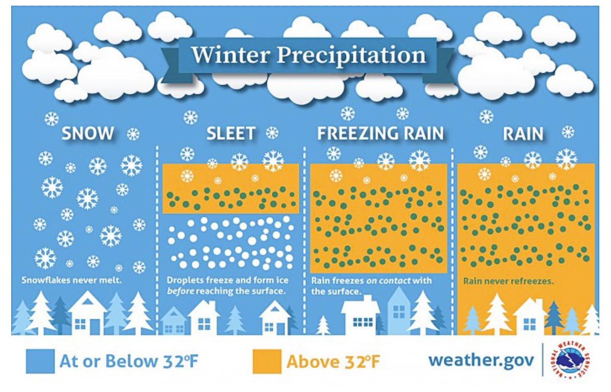
It means that rain droplets freeze back to small iceballs before they reach the ground. Ice pellets are a form of precipitation consisting of small, translucent balls of ice. They are smaller than hailstones and are different from graupel that we can experience with snow showers sometimes. Ice pellets are normally bouncing when they hit the ground or other solid objects (e.g. jackets, windshields, and dried leaves).
Sleet generally doesn’t freeze into a solid mass on the ground, unless it comes mixed with freezing rain. This normally occurs when heavier precipitation is present.
So, the amount of ice thickness we see forecasted above could locally lead to significant tree damage and power outages, as power lines could be damaged by tree branches crashing down onto them. The weight of ice accumulating on powerlines usually becomes quite significant once the ice thickness is more than 0.75 in (~2 cm).
SEVERE WEATHER OUTBREAK WITH ENHANCED TORNADO THREAT FOR THE CENTRAL AND SOUTHEAST U.S. ON THURSDAY
Odds are now also increasing for potentially a major severe weather outbreak from Wednesday late afternoon through Friday morning across portions of the southern central U.S. The upcoming winter storm will be accompanied by a severe weather outbreak with severe thunderstorms traveling across the southern Plains into the Mississippi Valley through the mid-this week.
A combination of powerful upper High along the East Coast and the arrival of the Arctic front from the north will introduce strong southerly winds, advecting high moisture and warmth from the Gulf of Mexico far north into the central parts of the country. Thus, the warm side of the frontal system will become unstable and significantly increase the risk of tornadoes and damaging winds.

On the attached chart above, we can see how large the frontal system is, covering the central parts with a sharp precipitation-type edge of the snow, freezing rain, areas of heavy rain, and severe thunderstorms to the south. Rather widespread severe storms can occur towards Wednesday evening into the night hours across north and east Texas, southeast Oklahoma into the low/mid-Mississippi Valley. Damaging winds, including tornadoes and torrential rain with flash floods, will be possible with the most severe storms.
The Storm Prediction Center (SPC) has issued a SLIGHT RISK of severe thunderstorms across parts of North Texas into central and eastern Oklahoma and western Arkansas through Wednesday night. Thunderstorms will begin across central Oklahoma late Wednesday evening, as the cold front moves into the region and continue east-southeast overnight.

On Thursday, as the winter storm moves further east, severe weather with flooding and tornado threats will develop from Louisiana, eastern Arkansas, and southeastern Missouri through Mississippi, Tennessee, Alabama into western Kentucky.
Very high moisture and warm airmass with around mid-60s dewpoints temperature will be in place across the Southeast ahead of the racing cold front, contributing to a moderately unstable environment. With a combination of strong southwesterly low-level flow (nearly 60 knots at 850 mbar) overspreading the warmth, thunderstorms will likely be ongoing along the front on Thursday and continue throughout the day
With anticipated strong low-level wind shear in the afternoon and especially evening hours, this suggests that some of these thunderstorms will be severe with a greater severe weather potential. Particularly across northern Louisiana and central Mississippi with tornado threat and damaging winds well possible Thursday night.
A NEW ARCTIC BLAST FOR THE CENTRAL CONUS
With the Polar Vortex being so intense this winter season, its southern lobe is responsible for particularly strong cold outbreaks far south across North America. As soon as the powerful blocking High strengthens over Canada, it gradually expands towards the United States around mid-week which typically leads to the massive transport of continental Arctic airmass far towards the south.
Normally, a high surface pressure develops under a dome of a strong upper-level ridge (blocking High). This week is actually slightly different than during the winter storm Landon, as there are two powerful high-pressure systems on each side of North America. Above 1040 mbar High sits along the West Coast while even stronger, nearly 1050 mbar High will be centered over the East Coast and Atlantic Canada.
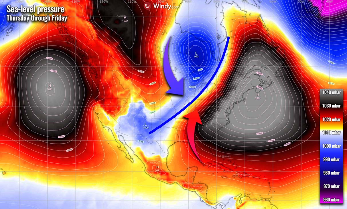
So the positions of the western High caused the enhanced northerly winds to transport a much colder Arctic airmass from central Canada towards the central and southern Great Plains. The general winds will be coming meridionally from the north-northwest direction and drag the temperatures down significantly across the central parts.
The extremely cold air will first spread into southern Canada, the Northern Plains, and the Upper Midwest on Thursday and intensify further on Friday. Air mass will be nearly 40 °F below normal across parts of eastern Kansas, northern Missouri, southern Iowa, and northern Illinois. And indeed also farther north across Upper Midwest into Minnesota, Wisconsin, and Michigan.
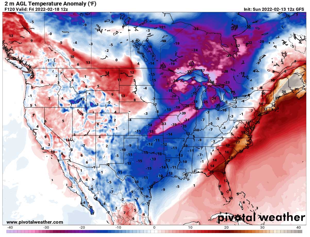
As we can see from the chart above, a much colder air mass in the wake of the Arctic front will also spread towards the southern Plains again. Temperatures will be about 15 degrees F below normal there as well. Farther east, a sharp temperature gradient is seen along the eastward-moving cold front.
This new large pool of cold air mass will bring sub-freezing mornings for the southern Plains as well, including central Texas. northern Louisiana and Mississippi. Much colder farther north where fresh snow will be on the ground and airmass will be cooling fast as skies will clear Thursday night. Probably below -10 °F in northern Missouri, eastern Iowa, and northern Illinois on Friday morning.

Daytime temperatures are forecast to climb back into the upper 40s to low 50s across central Texas to Lower Mississippi Valley on Friday, warming only into the low to mid-50s along the Gulf Coast.
Images used in this article were provided by Windy, TropicalTidbits, and PivotalWeather.
SEE ALSO:
A Dangerous Combo of Winter Storm Dudley and Eunice heads for the UK, Benelux, and Germany this week