A potentially monster winter storm is shaping up and will impact the East Coast beginning Friday through Saturday night. The general weather situation hints at a pair of storm systems that will emerge off the Eastern Seaboard into a powerful low-pressure system, known as the Nor’Easter storm. Thanks to an intense Polar Vortex aloft, frigid cold Arctic air mass will reach Florida, triggering a monster bomb cyclone that is forecast to bury the Northeast U.S. with 2 feet of snow.
Heavy snow with blizzard conditions, severe gusty winds, and coastal hazards are quite possible from North Carolina to New England, with the most significant impacts expected in eastern New England where the Nor’Easter will be the strongest and also travel very near the coast.
This Thursday, the cold is spread across a large part of the country. The large pool of extremely cold Arctic air is advancing across the Great Lakes towards the Northeast U.S. from central Canada. Temperatures are even below -10 °F in places across New England. Northwesterly winds are making the cold even worse, especially across the upper Midwest and the Lakes.
The bitter cold pool will intensity further through Friday and spread across the East Coast, reaching far south across the Southeast, including the central Florida peninsula over the weekend. The upcoming days will be significantly colder than normal for the region.
The video animation below reveals the low-pressure system that is forecast to intensify off the East Coast late Friday into Saturday. Significant snowfall will accompany this Nor’Easter storm. The land impact strongly depends on the track of the storm, meaning the closer or more north it travels, the stronger effects will follow regarding winds, heavy snow, and blizzard hazards.
High winds impact could cause coastal flooding, including beach erosion, particularly along the New England coast.
The general weather pattern begins its change this Friday with a cold front surging across the Northeast U.S, bringing another south of frigid cold, Arctic air mass from Canada. Very low windchills will make it dangerous in places. But before we dig deeper into evolution details, let’s first learn what is the main cause and driving factor behind the most significant pattern changes in winter months, known as the Polar Vortex.
THE POLAR VORTEX
Our atmosphere is made of six layers that are rounding the Earth, but most of the weather dynamics for all life on our planet occur in the lowest two, known as the troposphere and the stratosphere layers.

The lowest layer is the troposphere, where all the weather changes we encounter take place. The troposphere extends from the Earth’s surface or its sea level up to 12 km in the sky. The depth of it actually varies between 8 km to almost 20 km, depending on where you live. It is the deepest above the equatorial region, but it gets thicker above the North and South poles.
Right above the troposphere, there is a much deeper layer, known as the stratosphere. The stratosphere layer is about 10-50 km thick and the air in it is also very dry. We also find the Ozone layer in there, the one that has a vital role in the protection of our planet’s life.

Going straight to the point, for the dynamics in our weather, there is one important feature in the stratosphere, known as the Polar Vortex. The Polar Vortex is an enormous, three-dimensional (3D) ring of very powerful winds that surround the North and South poles, rotating about 20-50 km above the Earth’s surface. Normally, it is the strongest during the winter months.
So both the troposphere and the stratosphere layers are very crucial for the climate we live in, as the Polar Vortex covers most of the bottom half of the atmosphere, from the middle of Earth’s troposphere up into the stratosphere layer. The Polar Vortex, therefore, has an important and main role in the winter weather across the high and mid-latitudes, for both North America, Europe, and indeed Asia.

Although the vortex spins high above our heads, it still remains directly connected to the lower part of the atmosphere. Thus, the Polar Vortex gives our weather a daily shape in many ways, as it works as one large hemispheric circulation.
So, how the Polar Vortex actually forms?
When calendar months turn into autumn, the polar regions receive much less sunlight over time due to the stronger inclination of the Earth’s axis. The North Pole is therefore set into the position to start cooling down and polar nights without any sunlight occur. Although the North Pole is getting cooler with time, the atmosphere further south is still pretty warm as it continues to receive much more sunlight and energy from the Sun compared to polar regions farther north.
The cooling temperatures over the polar regions also translate into lowering the surface pressure and a similar process occurs in the stratosphere layer above. Therefore, the temperature difference between the North pole and the equatorial region increases, and a large low-pressure cyclonic circulation develops across the polar stratosphere.

Putting all these together, the Polar Vortex is basically acting as a very large cyclone. It covers the whole North Pole, down to the regions in the mid-latitudes (note it is the same in the southern hemisphere as well). The chart above hints at a very typical example of the Polar Vortex set above us, at around 30 km (18 miles) altitude which is near the top of the stratosphere during the winter season.
Thanks to the active Polar Vortex aloft, the trigger behind this upcoming weather change is the upper wave disturbance emerging from west-central Canada towards the eastern half of the U.S. At the surface, the low pressure strengthens as it tracks off the coast Friday night into Saturday in response to an upper-level disturbance diving from western Canada to the central and eastern United States.

This leads to a combination of fresh Arctic cold air with the intensifying storm along the East Coast, setting a stage for significant Nor’Easter winter storm impact for parts of the Northeast. The pressure will be deepening quite rapidly, thus this storm will become a so-called bomb cyclone, a meteorological term we use when the central pressure of the system falls rapidly. Typically, the lower the pressure – the stronger the storm.
WHAT IS A BOMB CYCLONE AND HOW DOES IT FORM?
The pressure change that we are seeing on the weather chart forecasts with the upcoming Nor’Easter is meeting criteria which means the system will be classified as a bomb cyclone. In other words, the surface cyclone will rapidly intensify, with its central pressure falling fast (or even extremely for some time). It normally develops when explosive cyclogenesis (also known as bombogenesis) with the rapid deepening of its barometric pressure occurs.

Generally speaking, a pressure change of at least 24 millibars within a 24-hour period is needed to meet the criteria that the system can be classified as a bomb cyclone. A cyclone is a non-tropical system, also known as an extratropical cyclone that develops rapidly from a low-pressure system. An example of such a bomb cyclone is seen on the satellite picture above, this is a typical Nor’Easter along the U.S. coast in the past.
The extratropical storms can grow very large in size, usually dominating a large portion of the ocean, in this case, the northwest North Atlantic (or the North Pacific on other occasions). The general movement of these types of systems in the Northern Hemisphere is to the northeast. Their large size produces severe to often extremely severe to hurricane-force winds, generating massive waves, coastal floods, and indeed severe winter storms with a blizzard over the land.

Actually quite similar to a classic extratropical cyclone, a bomb cyclone fuels from variations in the temperature, precisely between the warmer air mass towards the Equator and much colder temperatures towards the Arctic region. This is also happening vertically throughout the atmosphere.
Note, that these types of Atlantic cyclones are different from tropical cyclones that we normally track during the hurricane season. Those take their energy source from extremely warm sea surface temperatures found in the tropical region.
Statistically, the east coasts of the North American continent are known as the perfect breeding grounds for these types of cyclones during the late fall and winter months. This is because the interaction of Arctic cold continental air mass with the warm, moist oceanic tropical air mass provides lots of energy for a cyclone to rapidly develop or literally explode over the warmer Atlantic.

Therefore, the winter months often see bomb cyclones in the North Atlantic, the same with the Nor’Easter storms. these cyclones can actually occur all year round. Those cyclones, however, also include post-tropical systems that rapidly re-emerge from a decaying tropical cyclone once they eject farther into the northern North Atlantic sometimes.
On average there are about 60-70 bomb cyclone formations on Earth annually. About two-thirds (50) of those are found in the Northern Hemisphere, particularly off the east coasts of the U.S. and the North Atlantic. Some of those become Nor’Easters and impact the East Coast, Northeast, and New England of the U.S, including Atlantic Canada like Newfoundland.
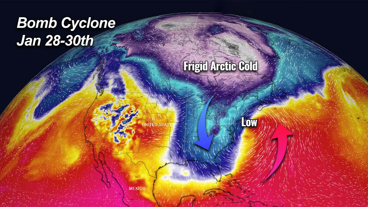
POLAR VORTEX DRAGS MORE FRIGID COLD FROM CANADA INTO THE U.S., REACHING FAR SOUTH TO FLORIDA
Again as we have seen it several times this Winter Season 2021/22, a textbook dipole weather pattern establishes across the North American continent. Such a setup helps a significantly colder, frigid air to emerge towards the eastern United States. This week and going into the weekend, the blocking High is strengthening across the western portions of the continent, while we have a new intrusion of Arctic air mass to its east.

This also means that a high surface pressure develops under such a strong blocking High aloft. The deeper pressure under the core of the Polar Vortex trough farther to the east will help to create a strong pressure gradient in between, so winds will increase in the channel, dragging colder temperatures towards the East Coast.
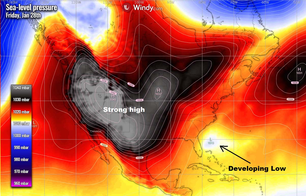
The following chart below hints at a very strong pressure forming across the West on Friday (nearly 1050 mbar over the Rockies). Notice also a developing shallow low to the east of Florida – that’s the upcoming bomb cyclone and Nor’Easter that will impact the Northeast over the weekend.
The particularly high pressure to the West will continue with a massive transport of much colder, frigid cold Arctic air mass from central Canada towards the eastern part of North America, with eastern Canada and the East Coast of the U.S. in the core of this blast. The flow is nearly a pure meridional, so the general winds are coming from the north-northwest across the Great Lakes towards the East Coast.
The significantly colder than normal Arctic air will also push deep south into the Southeast U.S., including the Gulf Coast and Florida. Putting the region into the more than 15 °C colder air than normal for the end of January. This will be the coldest weekend of the Winter Season 2021/22 so far for the Southeast and the (eastern) Gulf Coast.

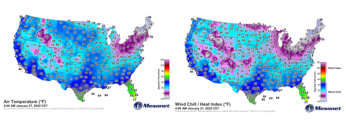
Daytime temperatures are forecast to remain in the 50s on Saturday, with the morning lows well into sub-freezing air from Mississippi across Alabama to Georgia, including the Florida Panhandle and northern parts of the peninsula. It has not been as cold yet this winter season in this part of the country. Only the far southern Florida will remain in the 60s, for now.
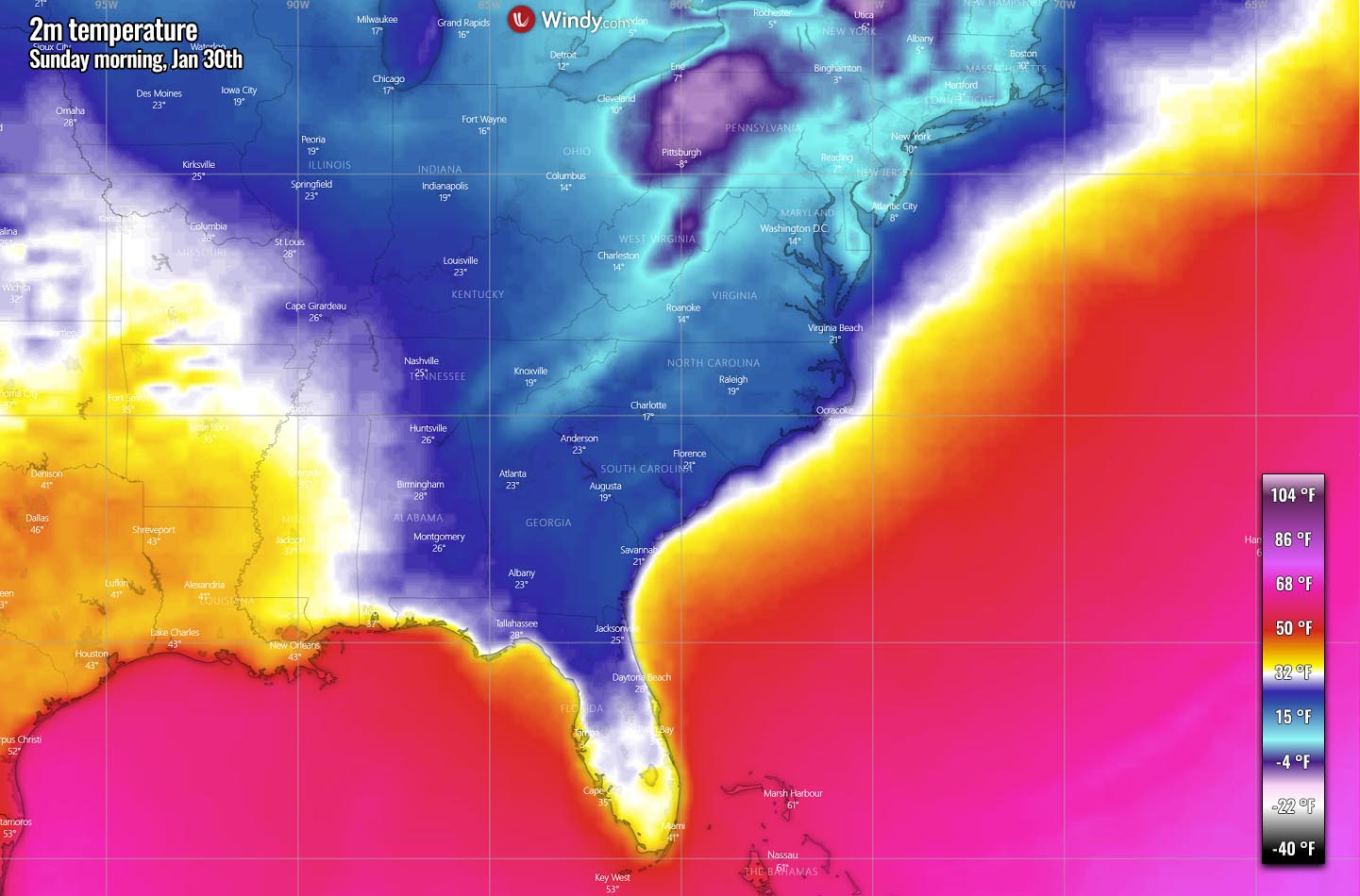
It will be indeed even colder farther north across the Midwest and Ohio Valley, more extreme towards the Great Lakes and Northeast on Saturday morning. Temperatures in the lowest 10s from Iowa and northern Missouri through Illinois and Indiana to Ohio and West Virginia. Low-20s in Washington D.C.

Sunday morning will also again be pretty cold across the Southeast, particularly from Georgia across Carolinas to Maryland. The lowest temperatures will be in the 10s, low 20s in Georgia. The mid-20s are also quite likely across northern Florida and east-central Alabama, so even colder than on Saturday.
Near-freezing temperatures are also forecast as far south as southern Florida on Sunday.
Bitter cold Sunday morning is forecast across the Ohio Valley, with -5 to -10 °F across eastern Ohio, western Pennsylvania, and western New York. Low 10s across New Jersey and Connecticut to Massachusetts. Great Lakes and Northeast will be extremely cold, especially as combined with strong to severe winds with an exploding Nor’easter bomb cyclone along the coast.
The overall air mass will therefore be well below normal across the Southeast. So we often use the Meteogram charts to understand how anomalous are the temperature forecasts when Arctic outbreaks occur, especially this far south.
Attached below is two Meteograms, one for Atlanta (left) and another for Orlando (right chart) in Florida. Both clearly reveal that the new Arctic blast led by the Polar Vortex aloft will be pretty strong.
While the bottom part of the chart is used to represent the precipitation, we can notice there will only be dry cold, so no snow or precipitation, in general, is forecast across the Southeast. Atlanta is currently at around slightly below normal temperatures for this time, 37 °F (or 3 °C), with a forecast for a remarkable drop of nearly 25 °F (13 °C) as the core of the Arctic blast emerges on Saturday night. Atlanta also hints a lot of rain will follow next week.
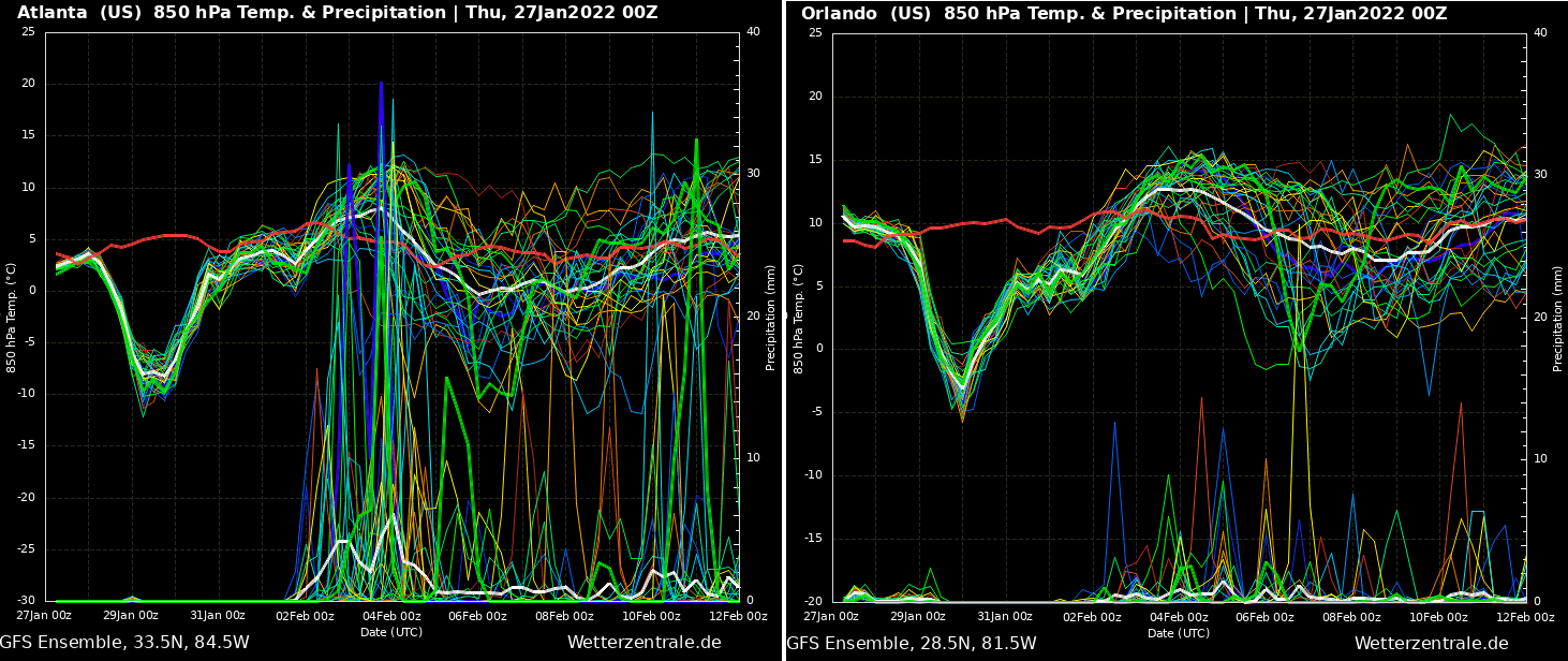
The chart for Orlando is even more impressive. While the temperatures are around 50 °F (10 °C) on Thursday, those will drop sharply on Saturday night into Sunday, coming to around 23 °F (-5 °C) – that is more than 25 °F colder weather that are experienced now. Temperatures will, however, return back to normal through early February, so the cold pool will not be particularly long-lived.
POLAR VORTEX TRIGGERS A NOR’EASTER STORM WITH 2 FEET OF SNOW LIKELY FOR THE NORTHEAST
The coming weekend is painting a particularly dangerous weather situation across North America and the Northeast U.S. in particular.

With a so-called Rex blocking pattern on Friday, meaning a high pressure surrounds a developing low near Florida that ejects towards the northeast and rapidly intensifies into a bomb cyclone, a powerful Nor’Easter.
A more Arctic cold air mass arrives on Saturday that will lead to the rapid intensification of the surface frontal system along the East Coast, with Winter Storm conditions rapidly approaching. Bringing major snowstorm across parts of the East Coast further into Northeast and New England. And also into Atlantic Canada on Sunday.

As a result of the surface pressure system placed under the low aloft, a combination of much colder temperatures and moisture surging north from the south triggers heavy snowfall along the broad swath from eastern Carolinas towards New England.
Around 15 to locally even more than 20 inches (2 feet or 50 cm) of snow is forecast in the core of the swath. Although it is still a bit uncertain where exactly the Nor’Easter center will travel, the amount of snow cover may eventually change from the current forecasts. But those that will be impacted, will experience heavy snow blizzard and whiteout conditions.

Attached next is the comparison chart of two main weather models, we can see some differences in the overall swath position of the most significant snow amounts. One weather model is taking it a bit more to the northwest than the other, thus meaning the bomb cyclone would travel closer to the coast and being a more significant impact.
Nevertheless, the far eastern portions and coastal areas of Maryland, New Jersey, and across most of Connecticut and Massachusetts will likely experience extreme winter weather with very heavy snow, blizzard conditions, and significant travel disruptions. Those include Boston and Providence, Rhode Island which could end with 2 feet of snow!

A major winter storm with very heavy snow and blizzard conditions will then continue across New England on Saturday night, becoming particularly intense for portions of Nova Scotia, Canada as well.
At the time the developing system emerges across the Mid-Atlantic, its pressure gradient considerably tightens against the higher pressure over the land, thanks to a typical occurrence of a powerful Nor’Easter storm. This will then introduce very strong to locally severe winds along the East Coast and New England in particular.

Snow will develop across much of the mid-Atlantic and Northeast coastlines through the Friday overnight hours, becoming heavy in many areas, all depending on the bomb cyclone’s track. The Nor’Easter will likely reach its peak intensity somewhere near or very near the coast of the New England coast on Saturday, possibly with pressure in the low 970s.
Winds will be the strongest there, so expect coastal flooding and erosion as well, thanks to major waves that will result from the winds as a result of a strong pressure gradient in place. High winds in some coastal areas could be damaging and strong enough to knock out power by fallen trees.

Keep in mind that a system tracking farther west could make the situation worse more inland, as a combination of snow and strong winds would impact from the New York City tri-state area to the coastal mid-Atlantic region. Including areas as far south as the Delmarva Peninsula and extreme eastern parts of Virginia and North Carolina too.
There should be a sharp gradient between heavy snow band and much smaller amounts on the storm’s western fringe, depending on its track. Roughly from the Jersey shore to eastern Pennsylvania or from the Delmarva Peninsula to the western suburbs of Washington, D.C. in particular.
Images used in this article were provided by Pivotal Weather and Windy.
SEE ALSO:
A change in the pattern is coming as we head into February, with a warm-cold wave