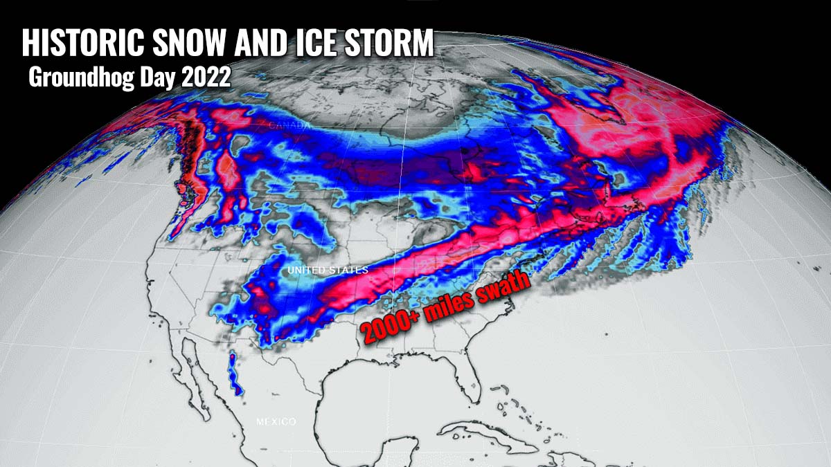
Thanks to a deep Polar Vortex lobe over Canada recently, significant winter weather continues across the U.S. Yet another dangerous winter storm is shaping up for this week’s Groundhog Day on Wednesday. After the record snow and intense blizzard across the Northeast on Saturday, the new snowstorm, named Landon, with also a high-risk ice storm potential, is forecast to impact millions across a more than 2000 miles swath from Texas across the Midwest to New England. In the storm’s wake, the coldest Arctic cold blast of the Winter Season 2021/22 will push far south to the western Gulf Coast.
Mid-winter is often a period when the most intense cold outbreaks and snowstorms develop across the North American continent. Thanks to a massive plume of frigid, Arctic cold air from Canada into the United States, particularly dangerous ingredients will be in place ahead of it racing south this week.
A Winter Storm Landon is expected to bring historic snow and dangerous ice extending along a more than 2000 miles long track. Travel disruptions and flight delays are expected across the nation from Groundhog Day through Friday this week.
This Saturday, the Nor’easter storm Kenan, a rapidly deepening bomb cyclone brought record snow to the Northeast, buried millions under more than 2 feet of snow. Violent winds were accompanied by the deep low, peaking at nearly 100 mph along the coast of MA. Blizzard conditions slammed a large part of the Northeast, zero-visibility conditions shunted down travels and hundreds of flights were canceled.
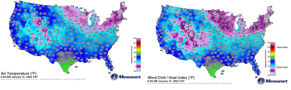
The cold in the Kenan’s wake has spread across the central and eastern portions of the country, temperatures are well below freezing in many areas. The coldest day of the last four years was reported also across Florida, with frosty mornings as far south as the southern peninsula on Sunday. The coldest air, also thanks to the strong winds present, remains across the Northeast and New England, and Upper Midwest.
The eyes of the weather forecasters are now already turning towards the next system brewing on the horizon. It is shaping up to potentially be of historic proportions. For the upcoming Groundhog Day on Wednesday, the confidence of increasing a major winter storm Landon will develop off the southern Rockies and move across the Midwest towards the Great Lakes and Northeast U.S.
The swath of the potentially significant impact stretches across more than 2000 miles from Texas to Maine, with winter weather conditions expected. Major snowstorm, dangerous and potentially damaging ice storm is now increasingly likely to bring havoc from mid-Wednesday through Friday for tens of millions along its path.
Expect significant travel delays, numerous flight cancellations, and road closures again. This system is forecast to become the strongest of the Winter Season 2021/22 and is certainly the one you don’t want to play with.
The general weather pattern begins its change early Wednesday with the arrival of yet another cold outbreak from Canada towards the south. Under the deep core of significantly colder Arctic mass to the north, a powerful high-pressure system with nearly 1050 mbar develops. A perfect recipe for the frigid cold and extremely low wind chills, becoming dangerous in many areas.
The main driving factor behind this cold and the upcoming Groundhog Day winter storm Landon is the Polar Vortex above us. The one that has been particularly intense this season and is showing no signs of weakening anytime soon.
THE POLAR VORTEX ABOVE US
If we think about how our atmosphere is built, we have six layers that are rounding the Earth. Most of the weather dynamics for the life on our planet occur in the lowest two layers. They are known as the troposphere and the stratosphere layers.

The lowest of the two is the troposphere layer, this is where all the weather we encounter takes place. The troposphere extends from the surface (sea level) up to 12 km above our heads. Its depth varies between 8 km to almost 20 km, depending on where you live. The troposphere is the deepest above the equator, but it gets much thicker above the North and South poles.
The next layer above the troposphere is a much deeper one, known as the stratosphere. The stratosphere layer is around 10-50 km thick and it is also very dry. Note that, the Ozone layer, the one that has a vital role in the protection of our planet’s life, is also found in this layer.

An important part in the stratosphere, that drives the dynamics in our weather, is known as the Polar Vortex. The Polar Vortex is an enormous, three-dimensional ring of very powerful winds above us. It surrounds both the North and South poles and is rotating about 20-50 km above the Earth’s surface. The polar Vortex is the strongest during the winter months.
Basically, both the troposphere and the stratosphere layers are very crucial for our planet’s climate. The Polar Vortex literally covers most of the bottom half of the atmosphere, so from the middle of Earth’s troposphere up into the stratosphere layer. Therefore, has an important role in the winter weather across the high and mid-latitudes, for all the continents, North America, Europe, and indeed the whole of Asia.

So even the vortex spins very high up above our heads, it remains connected to the lower part of the atmosphere. Thus, the Polar Vortex gives our daily weather a shape most of the time, as it works as one large hemispheric circulation.
So, how the Polar Vortex actually forms?
During the autumn months, the polar regions in the northern hemisphere receive much less sunlight over time. This happens due to the stronger inclination of the Earth’s axis. The North Pole is therefore set into the position that it starts cooling down, polar nights without any sunlight occur there.

But although the North Pole is getting cooler with time, the atmosphere layer further south is still pretty warm. It further continues to receive much more sunlight and energy from the Sun compared to polar regions farther north.
The cooler temperatures across the polar region also translate into lowering the surface pressure, a similar process also occurs in the stratosphere layer above. Therefore, the temperature difference between the North pole and the equator increases, leading to a development of a large low-pressure cyclonic circulation across the polar stratosphere.
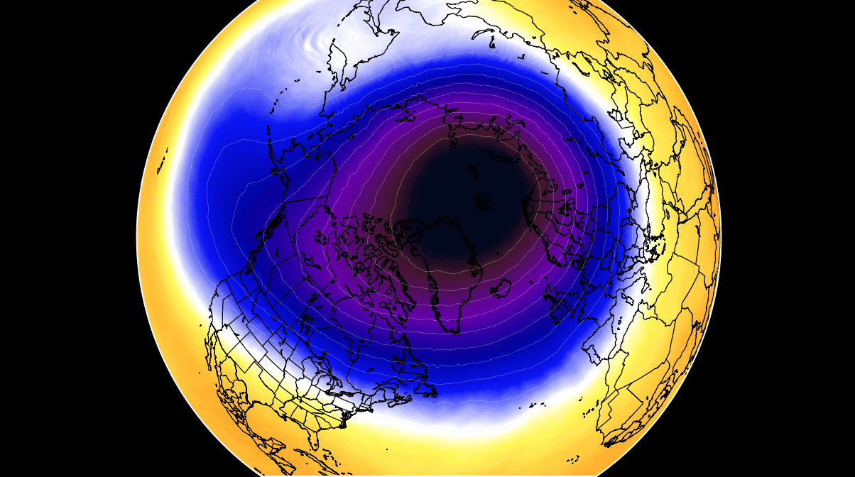
So, the Polar Vortex itself is acting as a very large cyclone and it covers the whole North Pole, spread down to the regions in the mid-latitudes. It is indeed the same in the southern hemisphere as well. The attached chart above hints at a textbook example of the Polar Vortex set above us, located at around 30 km (18 miles) altitude, that is near the top of the stratosphere during the winter season.
This Winter Season 2021/22, the very strong and active Polar Vortex aloft, is the main trigger behind the significant cold outbreak and winter storms blasting across Canada and the United States.
Also this week, the upcoming major weather change is led by the vortex above. A new upper wave disturbance moving across most of the U.S. will first develop a major snowstorm and ice storm, followed by a pretty intense frigid Arctic cold outbreak way down south to the Gulf Coast.
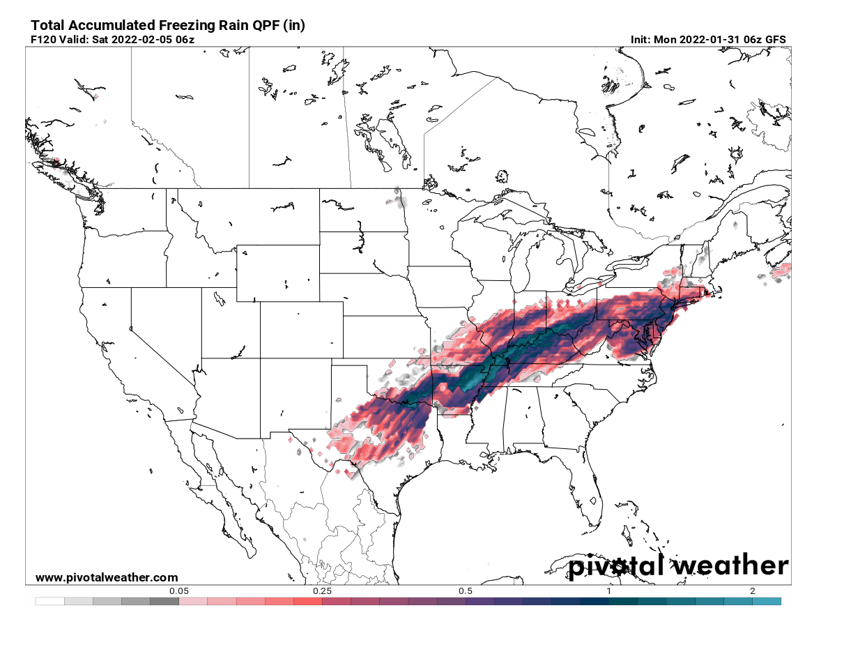
The major winter storm that is scheduled after Groundhog Day on Wednesday will bring a huge amount of snow in the narrow corridor from North Texas across the Midwest to New England. A more than 2000 miles long swath of significant winter weather is forecast, including a high-risk potential for a particularly dangerous ice storm from southern Oklahoma across the central Mississippi Valley and Ohio Valley to the Northeast U.S.
In the system’s wake, potentially the most frigid cold air mass of this winter season will spread south from Canada into the Great Plains and farther south to the Gulf Coast. It will bring temperatures of nearly 40 °F below normal as far south as Texas.
POLAR VORTEX TRIGGERS WINTER STORM LANDON ON GROUNDHOG DAY
The Winter storm Landon begins Tuesday night, with snow, sleet, and freezing rain expected to become more widespread from the southern Rockies towards the Great Plains and parts of the Midwest. The Groundhog Day on Wednesday will bring further wild winter weather in these areas, with the snow potential becoming very heavy in some areas.

The day after, on Thursday, snow, sleet, and freezing rain is forecast to persist from Central Texas to the Ohio Valley and Great Lakes with rain also developing into part of the Northeast which was under deep freeze this weekend. But it will be just temporary, as rain will change to snow as soon as a cold front sweeps through on Friday.
The potential for heavy snow accumulations is very high from the Central Plains into the Midwest and northern New England. Those areas also include major cities, Kansas City, St. Louis, Chicago, and Detroit in particular. Two to potentially even three feet of snow is shaping up on some weather forecast models, a historic amount to say at least.
The most extreme amounts of snow are forecast to accumulate from the central and southern Rockies, the Great Plains across eastern Kansas through central Illinois, northern Indiana, southeast Michigan, and northern Ohio Valley. 10-20 inches, possibly 25-30″ of snow is not out of the question along this 2000-mile-long swath of the Landon snowstorm.

Decent snow accumulations are also forecast for portions of western Texas, Oklahoma, some snow could fall as far south as Big Bend NP in Texas. Conditions will be pretty chilly as cold northerly winds will be blowing snow, reducing visibility and disrupting travel. With the progress of winter storm Landon farther east on Thursday, temperatures are forecast to plummet for more than 30 degrees F in about 24 hours across the South Central states.
With the progress of the snowstorm towards the Eastern Seaboard on Thursday, the main activity shifts back to the Northeast U.S. It won’t be as intense as the recent monster Nor’Easter on Saturday, but a wintry precipitation mess is expected, again disrupting ground and air travels, causing more delays.
DANGEROUS ICE STORM IN SIGHT
Areas from the southern Plains across the Mississippi Valley to Ohio Valley and nearly up to the coast of the Mid-Atlantic are also in the threat of a dangerous ice storm event on Wednesday and Thursday. The system’s track ejecting off the Rockies into the central portions of the country leads to its strengthening towards the Midwest. A typical response is it brings warmer air mass towards the north while freezing temperatures are battling it in the lowest level closer to the ground.
What appears increasingly likely with each weather model forecast recently is that the swath of the freezing rain potential is pretty large. Placed roughly along the southern fringe of the massive snowstorm to the north we’ve seen above. The amounts of ice accumulations are concerning in some areas, as often it leads to catastrophic tree and power lines damage.
The winter precipitation is forecast to begin across the Panhandles on early Wednesday as the low deepens off the Rocky Mountains, gradually intensifying and increasing in coverage across northern Texas and southern Oklahoma into Arkansas through Wednesday. The ice storm extends further across the mid-Mississippi Valley and Ohio Valley through Thursday.
While it will be very heavy snow to the north of the Arctic cold front associated with the system, freezing rain is a very likely scenario to the south. The return of much warmer air mass from the south is actually pretty significant, leading to strong thermal inversion against the cold from the north. The thermal inversion means the temperature in the lowest levels is much colder than those layers immediately above.

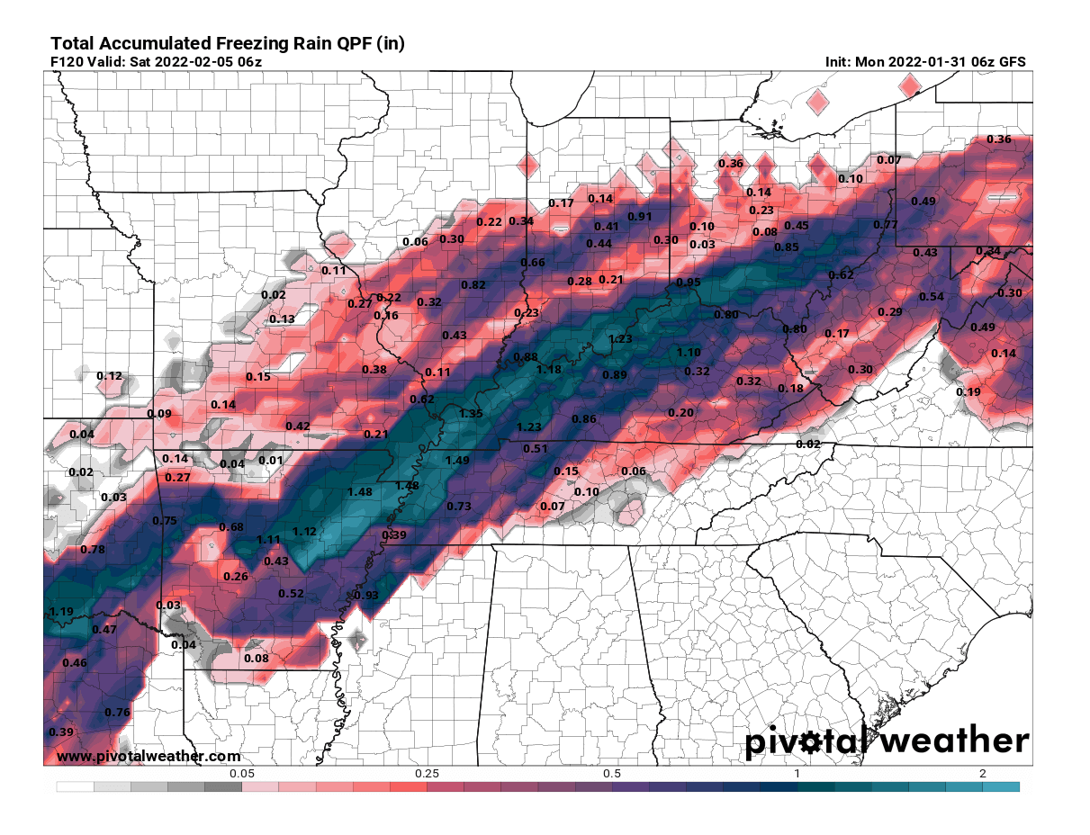
On the map for Wednesday night above, heavy snow can be seen across eastern New Mexico to TX/OK Panhandle and Kansas, farther northeast into northern Missouri to Illinois. But to its south, a narrow swath of freezing rain is forecast. Roughly from northwest Texas across southern Oklahoma into northern Arkansas, southern Missouri, and Illinois.
The total amount of freezing rain (ice) forecast through Thursday afternoon is particularly high from northern Arkansas to the Ohio Valley and those could be damaging and significantly impact travels. Portions of Arkansas, Tennessee, and Kentucky could be facing 1-2″ (3-5 cm) of freezing rain and therefore ice accumulation, causing black ice. These areas seem in the worst possible scenario for a dangerous amount of ice thickness.
Black ice is a term we use when the ice has developed (accumulated) on the surface of a roadway. It is mainly transparent but takes on the color of the surface of the road it is on. Once the ice gets wet from the outside temperatures warming up, it becomes dangerously slick and it has led to numerous deadly road accidents around the world in the past.
With very cold temperatures present near the surface and the already freezing cold ground, the ice should accumulate quite fast and result in an ice thickness rather quickly. The greatest ice accumulations in this ice storm event are expected from Wednesday night through Thursday evening, with icy conditions lasting for about 12 to 24 hours or even more in some places.
Travel will become extremely difficult to nearly impossible at times, and particularly dangerous especially where freezing rain first occur, covered with fresh snow once the colder air mixes down from the north again.
Learn what is the freezing rain and what causes it
The freezing rain formation occurs when a layer of warm air aloft is placed above a layer of below-freezing (or subfreezing) air near/at the surface. Snowflakes that fall towards the ground, melt as they continue to fall through this warm layer.

If the snowflakes completely melt in this layer, then the precipitation is falling towards the ground as rain. But the ground is indeed much colder. The liquid droplet then froze in contact with exposed surfaces, forming a black ice thickness. If the thickness of the near-surface cold layer is high enough, sleet or ice pellets form. Meaning that rain droplets freeze back before they reach the ground.
Sleet is a form of precipitation consisting of small, translucent balls of ice. Ice pellets are smaller than hailstones and are different from graupel that we can experience with snow showers sometimes. Ice pellets often bounce when they hit the ground or other solid objects (e.g. jackets, windshields, and dried leaves). And they generally don’t freeze into a solid mass, unless they come mixed with freezing rain. Normally when more heavy precipitation is present.
Such an amount of ice thickness we see forecasted above could locally lead to significant tree damage and power outages due to power lines damaged as tree branches crashing down onto them. The weight of ice accumulating on the branches or powerlines usually becomes quite significant once the ice thickness is more than 0.75 in (~2 cm).
THE COLDEST ARCTIC BLAST OF THE SEASON WILL REACH DEEP SOUTH
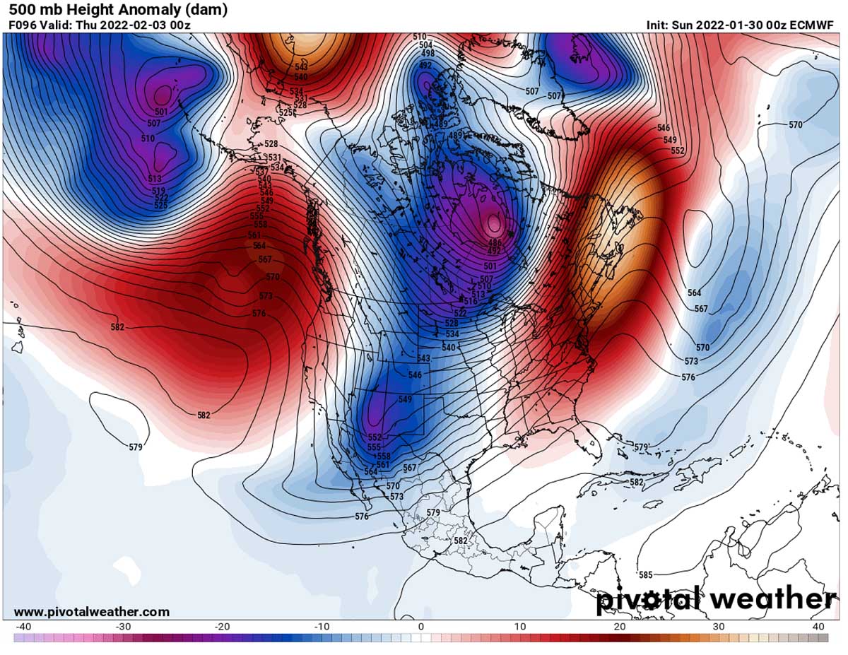
With the southern lobe of the Polar Vortex digging farther south across North America, a powerful blocking High strengthens over Canada and gradually expands towards the United States on Wednesday into Thursday. This is a typical setup before the massive continental Arctic airmass intrusion turns towards the south.
Normally, high surface pressure develops under such a strong blocking High in the upper levels. It will again be very high atmospheric pressure with nearly 1050 mbar in its center Wednesday night near the International US/CA border.

The High will cause the enhanced northerly winds to transport a much colder, frigid cold Arctic air mass from central Canada towards the central and southern Great Plains. The flow will be more or less meridional, so the general winds will be coming directly from the north-northwest direction and drag the temperatures down significantly.
The extremely cold air will first spread into southern Canada, the Northern Plains, and the Upper Midwest. Air mass will be nearly 50 °F below normal across parts of North Dakota and northern Minnesota on Thursday morning, which is frigid even for these areas used to the cold. It will put these regions into a deep freeze.
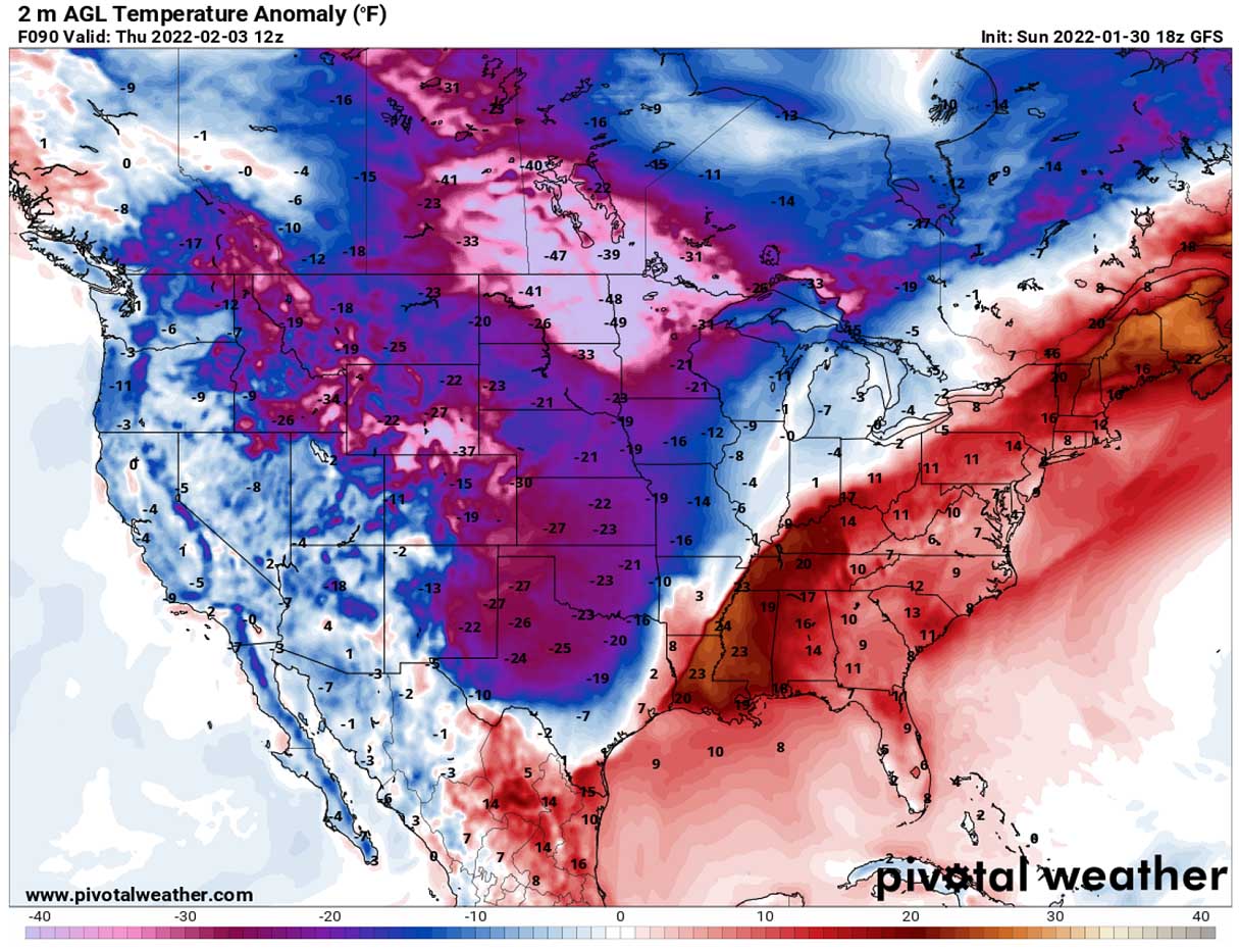
As we can see from the chart, the much colder air mass in the wake of the Arctic front, associated with the Landon storm, will already spread into the southern Plains. With temperatures about 25 to 30 degrees F below normal there as well. Farther east, a sharp temperature contrast is seen along the front.
Once the Winter Storm Landon shifts farther east/northeast Thursday night, the frigid air mass in its wake will have the open path to plunge way more towards the south. Friday will be extremely cold for the south, including parts of Kansas, Oklahoma, and especially Texas and eastern New Mexico.
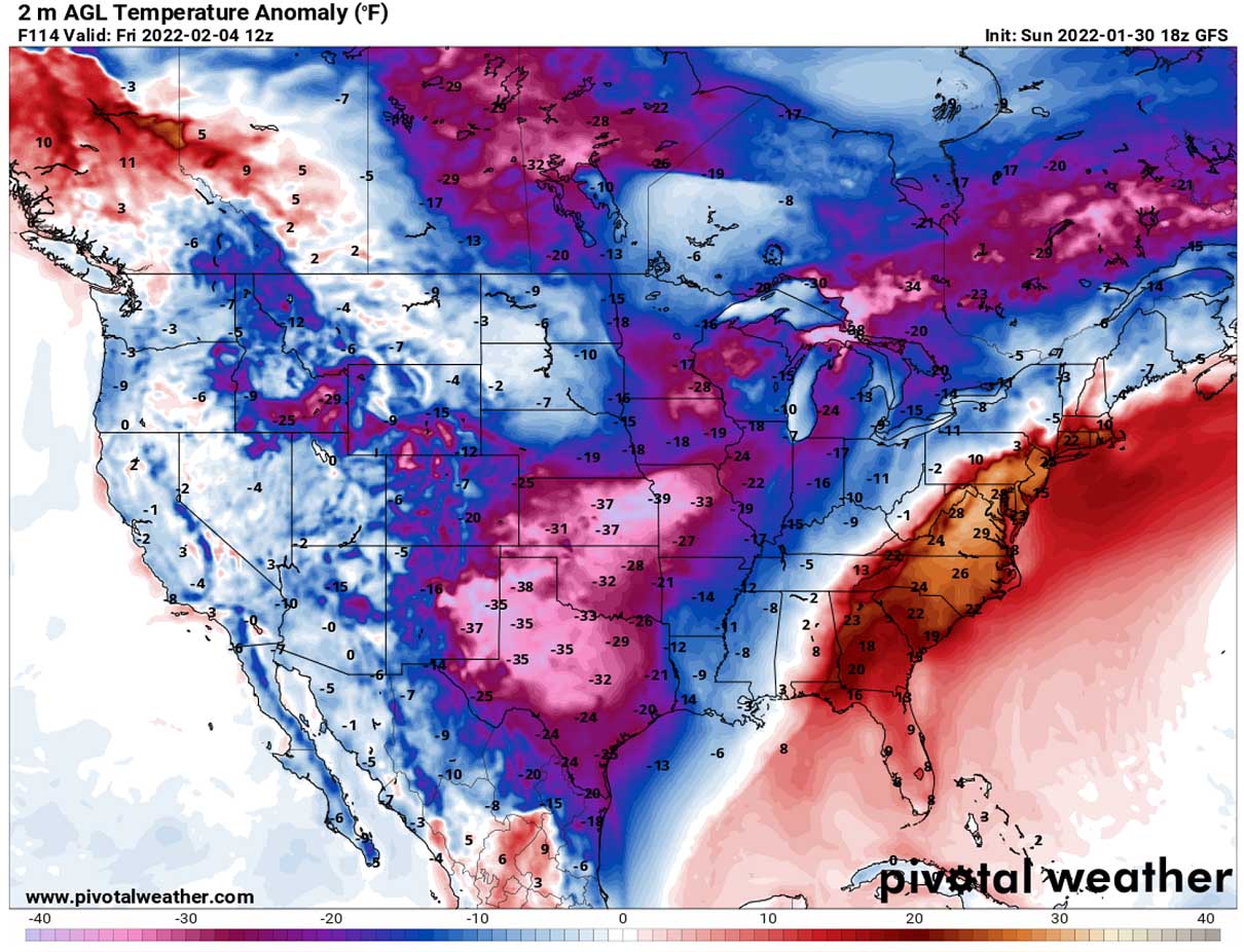
The large cold pool will be the coldest of the Winter Season 2021/22 so far for the southern Plains, leading to well-below freezing temperatures for much of Texas as well.
Subfreezing temperatures could also occur in deep south Texas on both Friday and Saturday, much colder farther north across the rest of Texas and indeed across Oklahoma and Kansas.

Daytime temperatures are forecast to stay below freezing as far south as central Texas on Friday and Saturday, warming only into the low 40s along the Gulf Coast. It hasn’t been this cold in this part of the country this winter yet.
Images used in this article were provided by Windy, TropicalTidbits, and PivotalWeather.
SEE ALSO: