A colder Weather pattern, powered by the Polar Vortex, prevails over much of the eastern half of the United States. With the high pressure over the North Pacific, it sustains a cross-polar flow, bringing down colder air from the polar regions. But a warm break is now developing, followed by another wave of cold air into mid-February.
The Polar Vortex is a key short-to-medium term weather component during the cold season. It is strongly connected all the way from the ground up into the higher levels of the atmosphere.
This is why we take great notice of the activity (or lack thereof) high above in the stratosphere and monitor it all the time. In the next days/weeks, the Polar Vortex will play an interesting role, helping to drive dynamic weather into the United States all the way to Spring.
First, we will quickly and simply learn what the Polar Vortex really is and how is it so influential. We try to explain this in most of our winter articles, as this is an important part of every winter season. Such knowledge can really help to understand the bigger picture of how the weather works in the large picture.

NORTH HEMISPHERE POLAR VORTEX
Simply put, the Polar Vortex is like a very large cyclonic circulation, covering the whole north pole, down to the mid-latitudes. It has a strong presence at all levels, from the ground up into the middle atmosphere, but can have different shapes at different altitudes.
The Polar Vortex is so large that it can be divided into two altitude parts. One is the lower (tropospheric) part and the second is the upper (stratospheric) part. The stratospheric polar vortex plays an important role in weather development, while the lower tropospheric polar vortex actually “is” the weather that we experience.
But what is this stratosphere? The atmosphere has different layers. Our weather occurs in the lowest layer of the atmosphere called the troposphere. It reaches up to around 8 km (5 miles) altitude over the polar regions and up to around 15 km (9-10 miles) over the equator.
Above it, we have a much deeper layer called the stratosphere. This layer is around 30 km/18.5mi deep and is very dry. The Ozone layer can be found in the stratosphere. You can see the layers of the atmosphere on the image below, with the troposphere and the weather on the bottom and the stratosphere with the ozone layer above it.

The image below shows a typical example of the upper Polar Vortex at around 30km/18.5miles altitude in the middle stratosphere during the winter season. It has a very nice circular shape, with the temperature dropping the more we go towards the inner core.
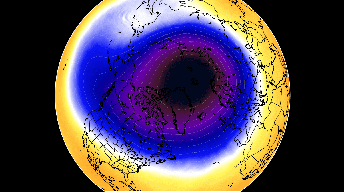
A strong Polar Vortex usually means strong polar circulation. This can usually lock the cold air into the Polar regions, creating milder winters for most of the United States and Europe.
As a contrast, a weak (wavy) Polar Vortex is just as dynamic as it sounds. It has a much harder time containing the cold air, which can now escape out of the polar regions, into the United States and/or Europe. Image by NOAA.

In the next image below, we have the polar vortex at a much lower altitude, around 5km/3miles. The closer to the ground we go, the more deformed the polar vortex gets because it has to interact with the mountains and overall terrain and also with the strong weather systems.
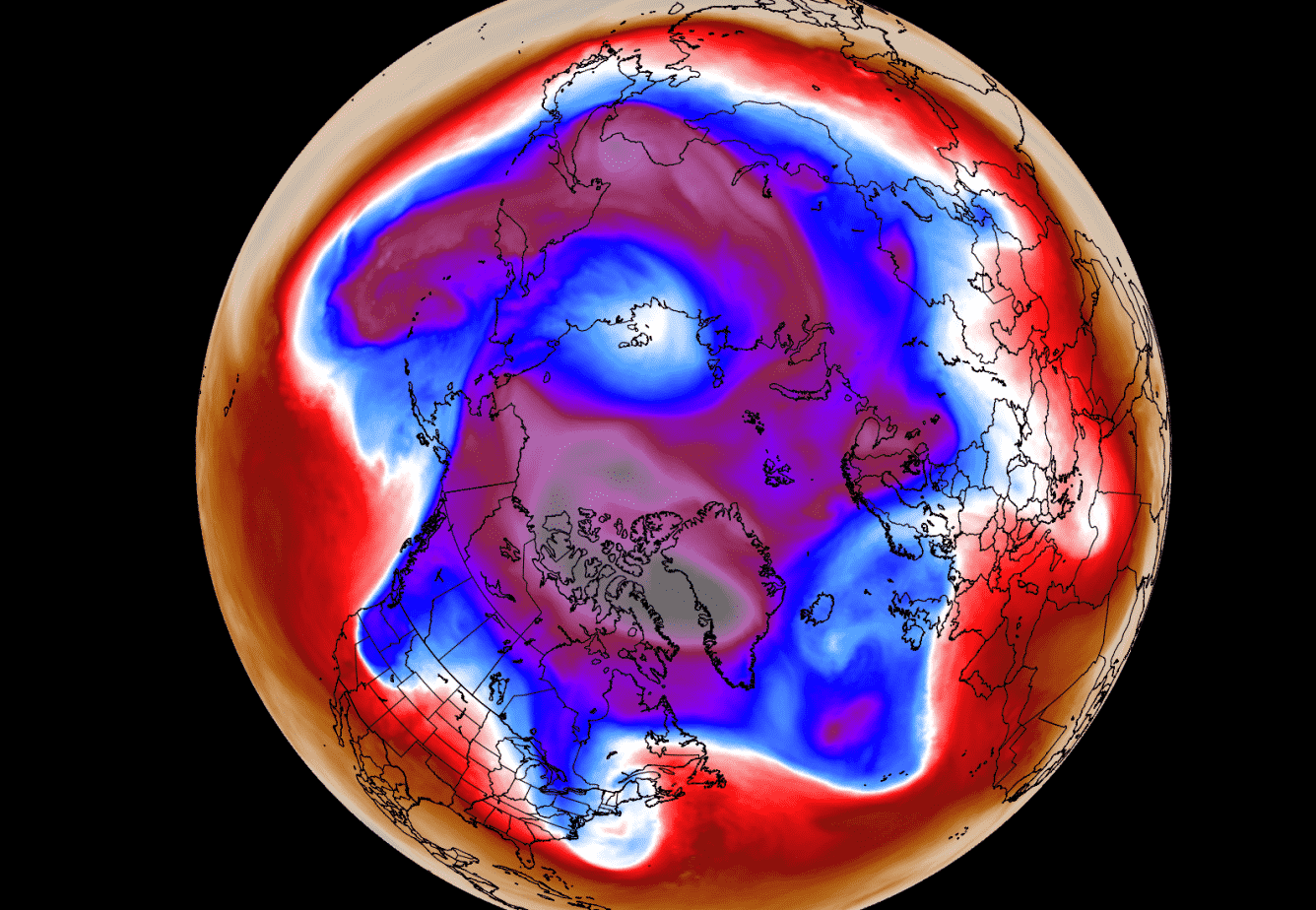
Be aware of the cold arms or so-called “lobes” extending out of the polar vortex. They bring colder air and snowfall into the mid-latitudes. These arms also pack a lot of energy and can create strong winter storms, like for example Nor’easters in the United States or very strong wind storms across the North Atlantic.
For an even better idea, we produced a high-resolution video for you, which very nicely shows the Polar Vortex spinning over the Northern Hemisphere at the 30mb level, around 23km/14miles altitude.
Video shows the NASA GEOS-5 analysis for the past 10 days. Notice how the polar vortex covers a large part of the Northern Hemisphere. You can nicely see how it spins over the Northern Hemisphere, driving also weather with its circulation.
But why (and how) does the polar vortex form?
Every year as we head into autumn, the polar regions start to receive much less sunlight. This way, cooling begins over the north pole. But as the polar regions cool, the atmosphere further south is still relatively warm as it continues to receive energy from the Sun.
You can see the winter solstice on the image below when the polar regions receive little to zero solar energy, compared to regions further south.

So, as the temperature difference towards the south increases, this also means pressure changes. A large low-pressure (cyclonic) circulation starts to develop across the Northern Hemisphere from the surface layers, far up into the stratosphere. This is known as the Polar Vortex.
While the stratospheric polar vortex is spinning high above our weather, it is still directly connected to the lower levels and can shape our daily weather in many ways, driving it as one large circulation over the entire hemisphere.
POLAR VORTEX IN THE WEATHER FORECAST
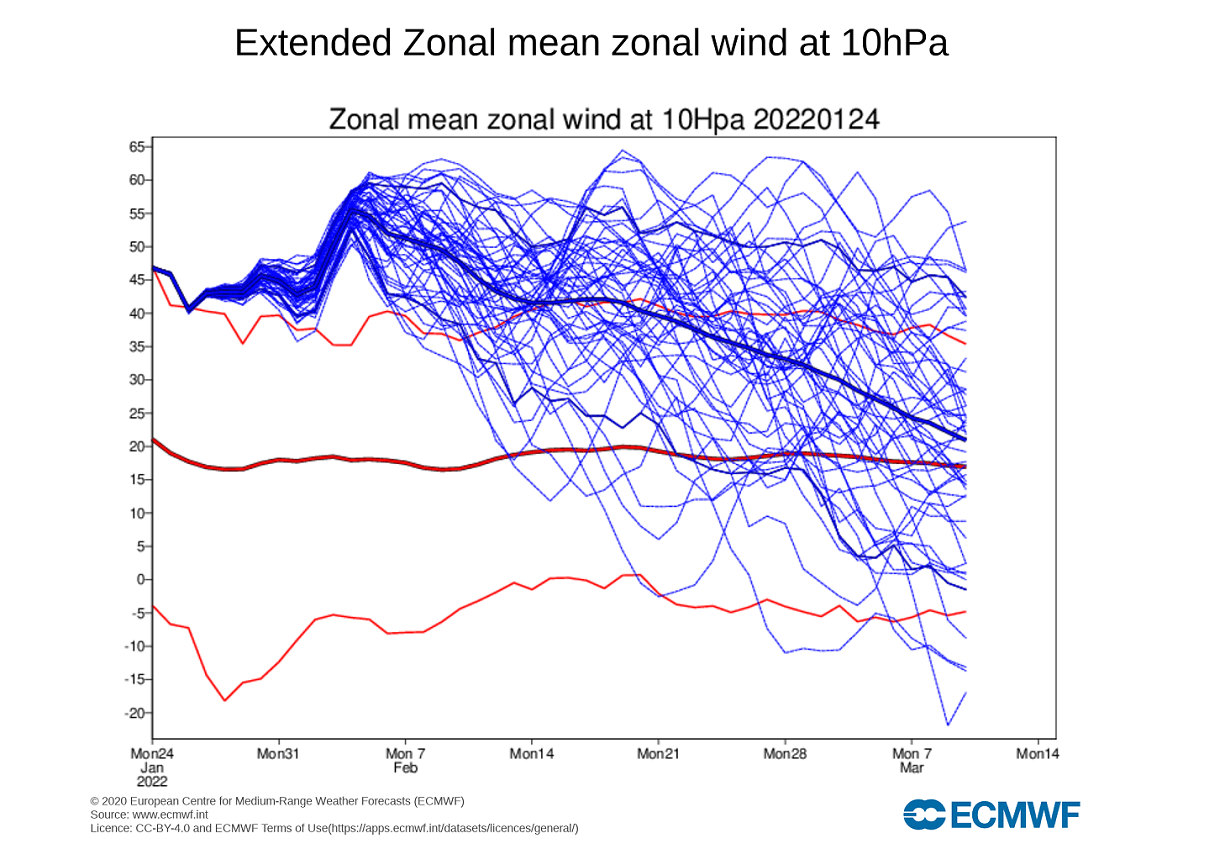
When looking at the polar vortex in the stratosphere, we use the 10mb level. That is around 28-32km (17-20 miles) in altitude. This altitude is considered to be in the mid-stratosphere and provides a very good representation of the general strength of the stratospheric polar vortex and its downward connection.
The strength of the polar vortex is most often measured by the power of the winds that it produces. This is typically done by measuring the zonal (west to east) wind speeds around the polar circle (60°N latitude). Below we have an ensemble forecast for the 10mb winds.

Currently, the polar vortex at the 10mb level is actually stronger than normal for this time of the year. It is forecast to remain at a strong level, with slight oscillations in-between. It is expected to have a short power boost in early February.
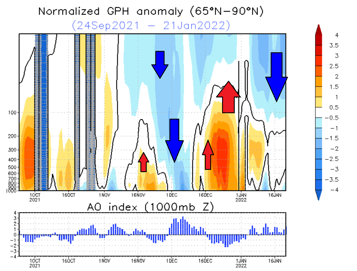
Looking at the pressure anomalies over the polar regions in the past three months, we can notice an interesting progression. The next image below shows pressure anomalies from the surface into the upper stratosphere.
You can observe the strong low-pressure buildup in the stratosphere in late November. That was a strong polar vortex, connecting easily down to the surface levels in early December. But strong high-pressure anomalies have emerged over the polar circle in December, which pushed back against the stratosphere, “disconnecting” the upper and the lower polar vortex.
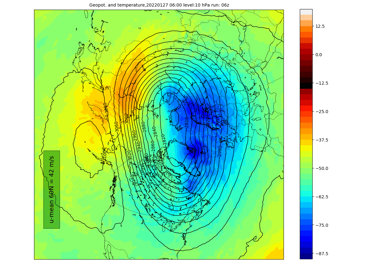
Looking at the current polar vortex development, we can see that the vortex is in a good shape. It doesn’t have the classical circular appearance and appears more oval in shape. It still has a strong and stable wind field. There is a semi-persistent high-pressure area in the North Pacific pressing against it, creating its oval shape.
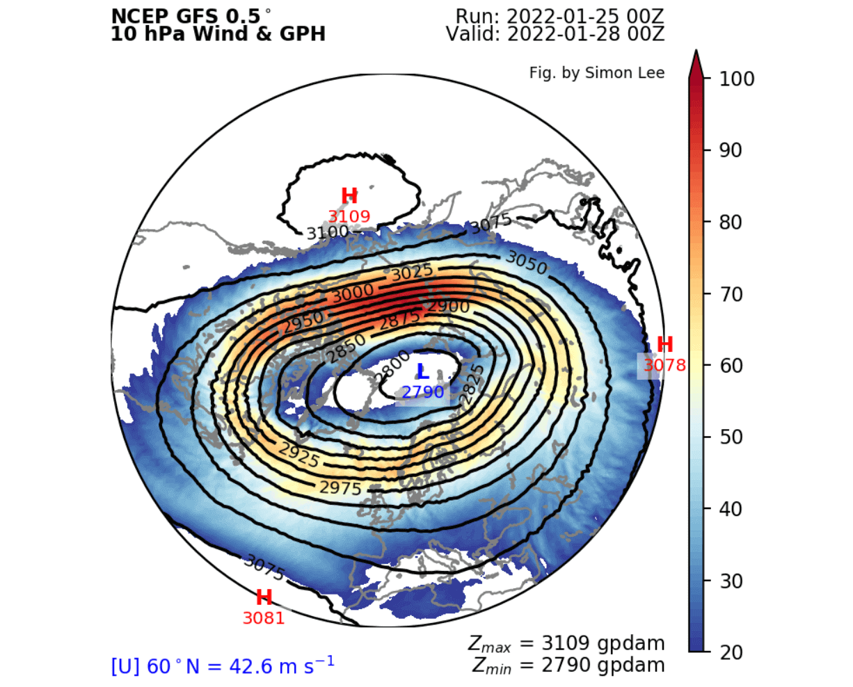
Taking a look at the temperature profile at this level, we see its cold-core over the North Atlantic, eastern Arctic, and Scandinavia. We can see the high pressure in the North Pacific, with some weak warm temperature anomalies around the cold-core. It is being deformed to extend down into the eastern parts of North America.
But, despite appearing disconnected, the upper and lower polar vortex is still just one large area of circulation. So while the exact core energy is perhaps not strongly connected, its shape can reflect on both levels.
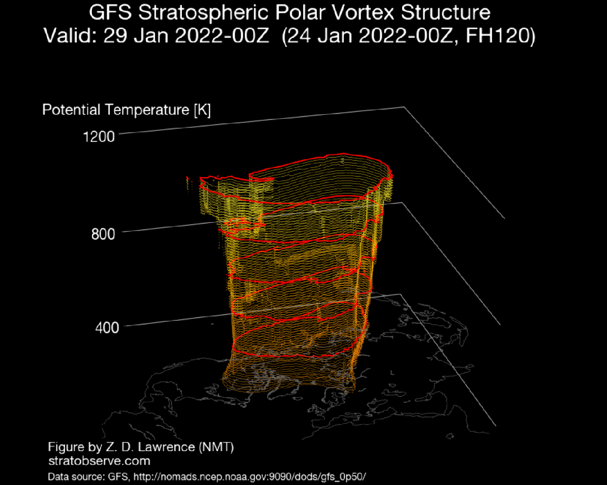
We can see that especially well on the 3D structure. Notice the elongated shape of the polar vortex in all the atmospheric levels, with an extension down into eastern Canada. That does show how the low-pressure system in that area is connected to the core structure of the Polar Vortex.
The vertical pressure anomaly profile also reveals this connection. We can observe the stratospheric low-pressure anomalies extending down from the stratosphere to the lower levels. A direct connection in the -60 to -90 Longitude is observed, exactly where the low-pressure system over eastern Canada can be found.

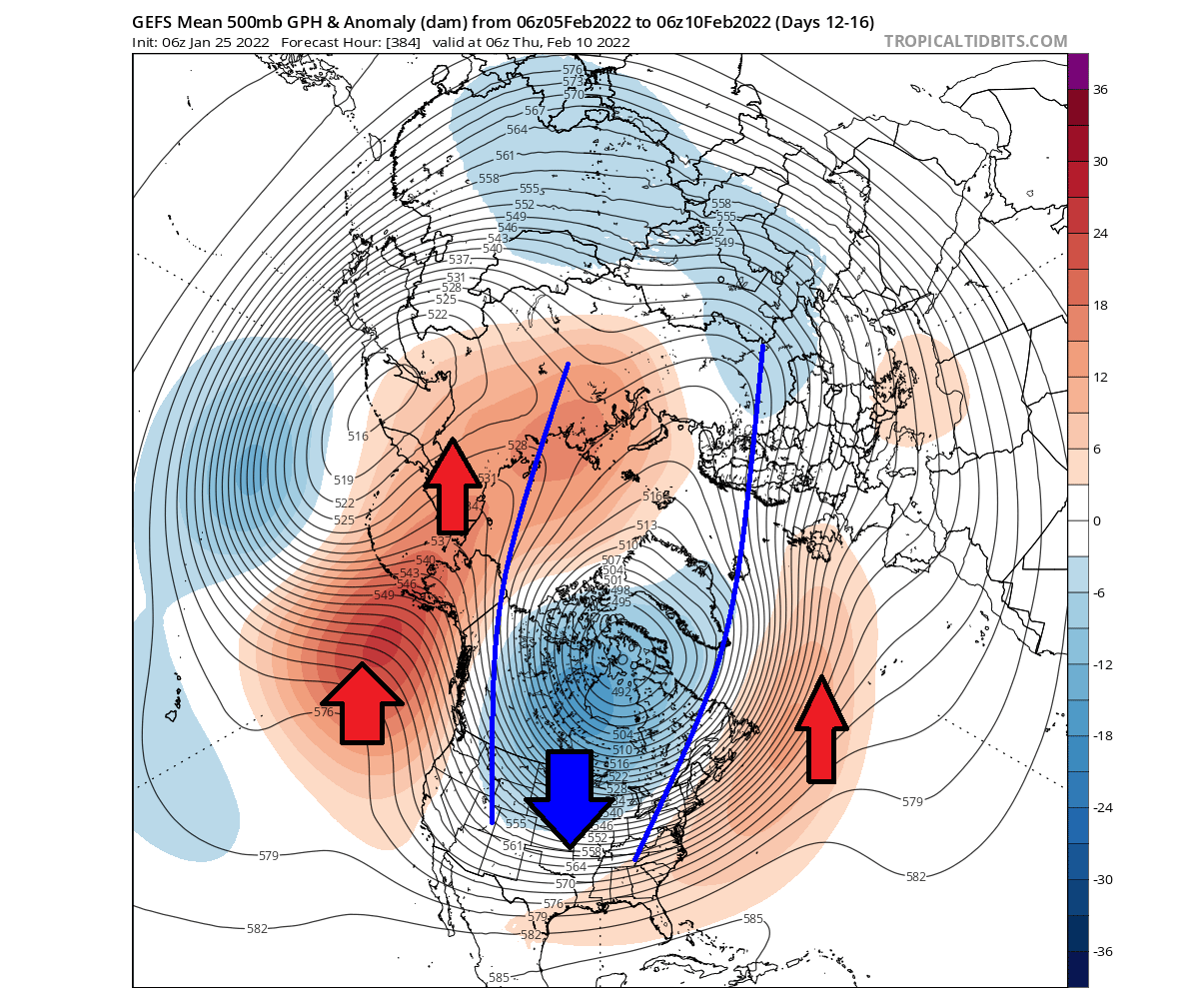
We can nicely see that if we look at the latest 5-day forecast of the pressure anomalies across the Northern Hemisphere. Notice the stretched profile of the lower polar circulation, also being compressed from the Pacific and the North Atlantic. This lower pattern is reflecting upwards, also deforming the polar vortex.
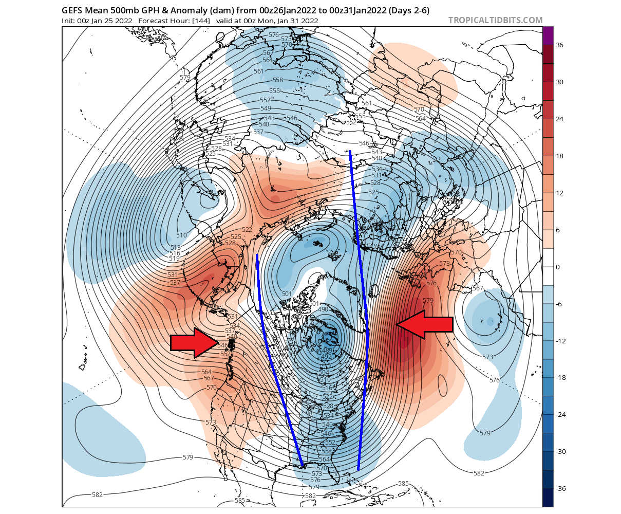
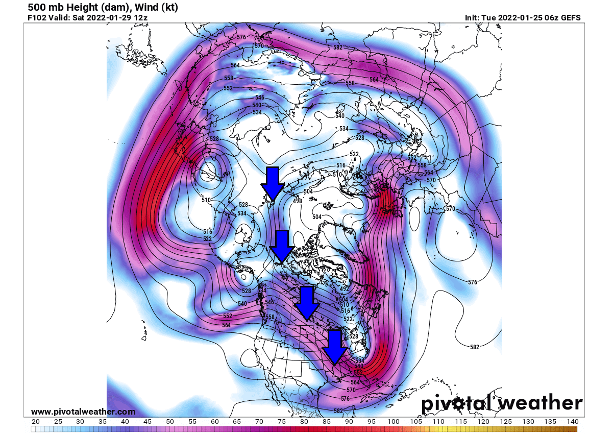
At the same time, that promotes a northerly flow from the polar regions and deepens the low pressure over eastern Canada. Looking at the jet stream forecast below, we can see this wind flow from the polar regions in the upper levels.
This is a special pattern, also known as the cross-polar flow, which tends to bring colder arctic air into North America, deeper from the northern regions.
This is a disruption pattern of the lower level polar circulation. The temperature forecast below for the same period shows the cold air anomalies in eastern Canada and the eastern United States. The cold northerly flow is amplified between the low pressure in the east and high pressure over the west.

Taking a closer look at North America, the coldest air will be moving over the eastern United States in the next few days. Colder weather is expected across the central and the northeastern United States, with the cold air eventually expanding into the parts of the southeast.
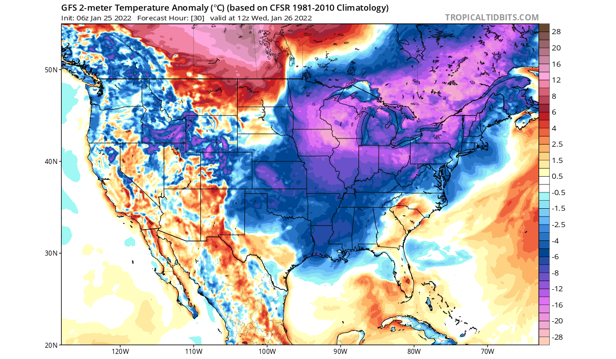
Some snowfall is expected with this cold air passage. A swath of snowfall is expected in south-central states with the cold air from the Rockies. The eastern Ohio Valley and parts of the northeastern United States will also receive some snowfall. But this cold air is dry and does not support a lot of precipitation.

A SHIFT IN THE PATTERN
Going into next week and early February, the pressure patterns will undergo a slight shift. An important change will occur over western North America. The high-pressure system in the North Pacific will strengthen, pulling down a low-pressure system into the western United States. That opens a window to a ridge building in the southeastern United States.
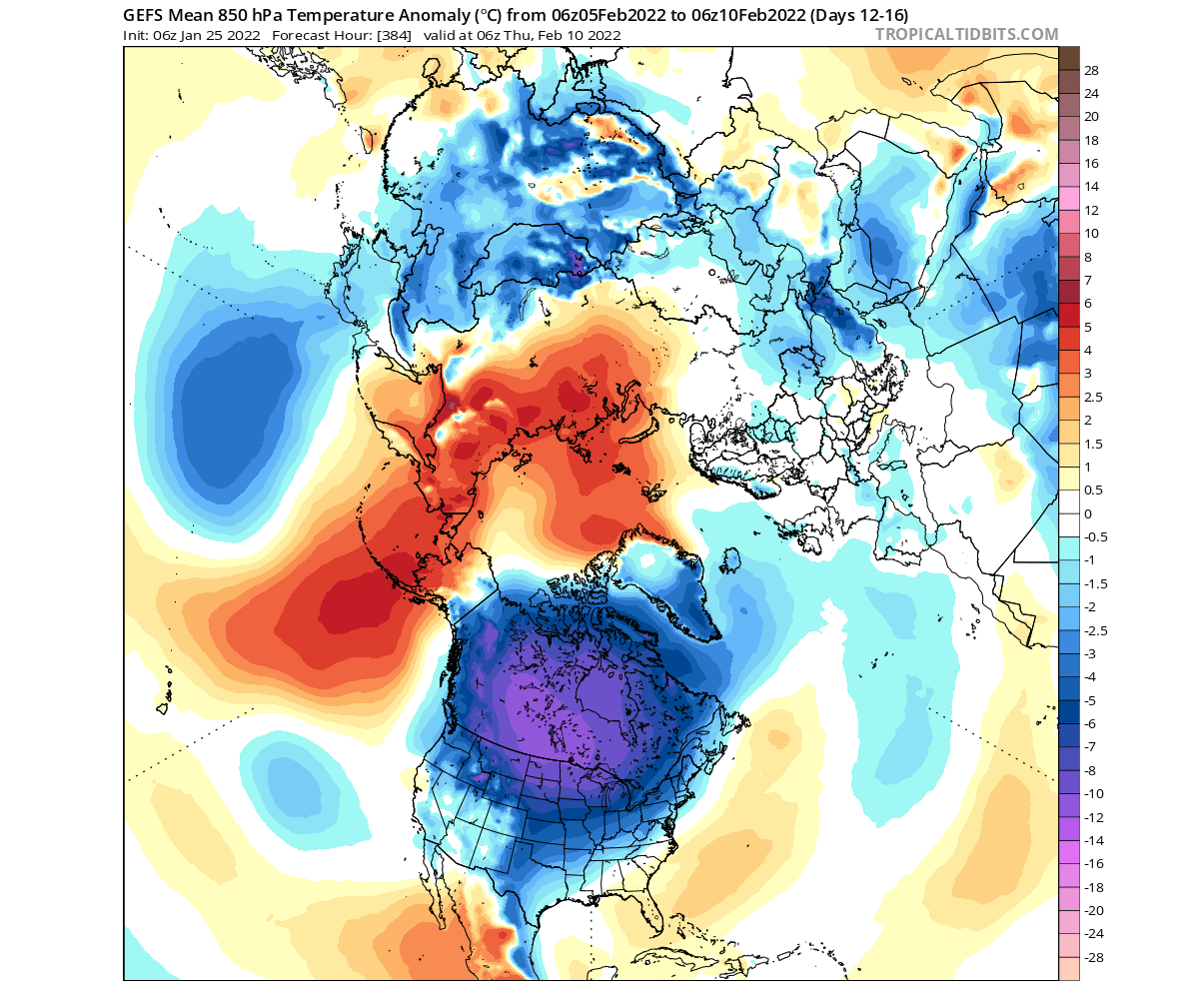
The temperature forecast for this period shows the accumulation of colder weather back over western Canada. Warmer than normal air is returning to the eastern United States, as the higher pressure and southerly flow expand from the south.

So how does the polar vortex fit into this?
During this time, the high-level (stratospheric) polar vortex will re-organize. But, it will regain its circular shape, which is its “higher-power” mode. It is perfectly centered over the North Pole and briefly pulls back from North America and more into Europe. Image by weatheriscool.

The colder airmass will accumulate and spread from western Canada into much of the western United States. Below is a temperature anomaly forecast for later next week, showing one of the likely weather scenarios.
A strong contrast temperature develops, with cold winter weather in the west/northwest and much warmer than normal temperatures over the eastern United States and eastern Canada.
Looking at the snow depth change for this period, we can see the snow depth increasing over the northern and western United States. We can see a huge reduction/melt of the snow cover over the northeastern United States, as much warmer than normal weather enters the region.
NOAA 8-14 DAY FORECAST
This is all nicely captured below on the official NOAA/CPC 8-14 day forecast for the United States. Colder temperatures will prevail over much of the western half of the country. Warmer than normal temperatures will prevail in this period under the influence of the expanding high-pressure zone over the eastern United States.

Looking at the official NOAA precipitation forecast, we more precipitation than normal over much of the United States. This shows that more moisture will be available, usually sourced from the south, on the border between the cold and warm air. Less precipitation is expected in the far southwest.

CROSS POLAR FLOW INTO FEBRUARY
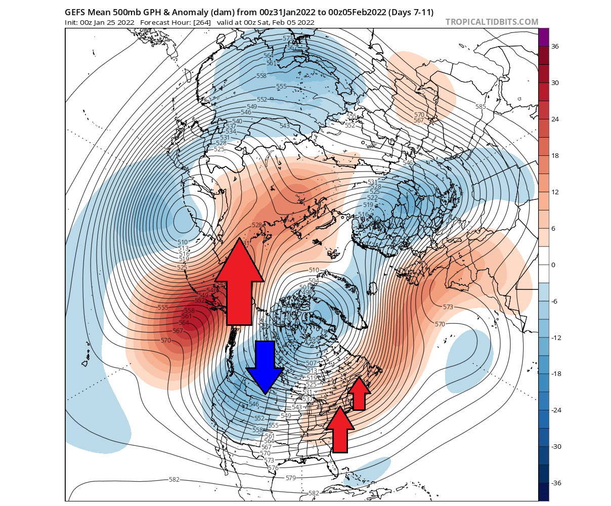
Going into mid-February, the pressure patterns will evolve further. The strong ridge over Alaska will rise deeper towards the north, stabilizing the cross-polar flow into North America. Due to the low-pressure system returning into eastern Canada, the high-pressure zone in the North Atlantic will also be a stable feature, helping to bring some colder air also into Europe.
Warmer anomalies over Alaska can be found on the temperature forecast, as the ridge there pushes further north and into the polar circle. That transports the colder air out of the polar regions and down into Canada and the United States.
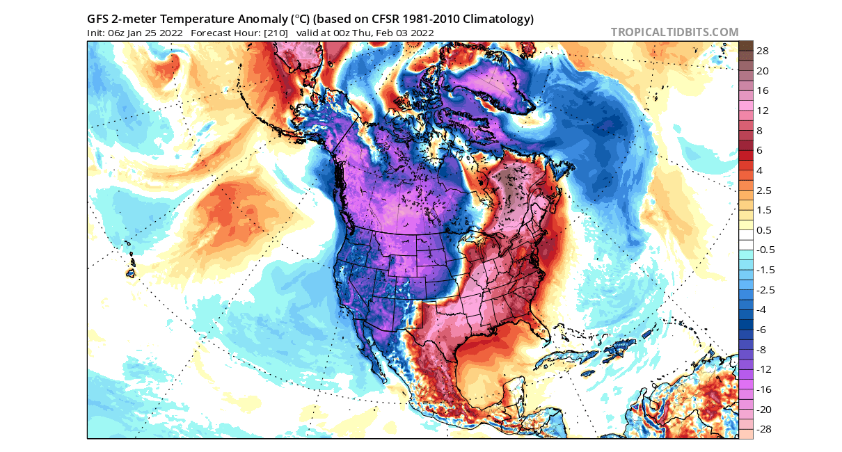
We can see a large area of colder than normal temperatures accumulating in Canada, extending down into the northern United States. That is the colder air being pushed out of the polar regions by the expanding high-pressure system from the North Pacific.
At this time, the stratospheric polar vortex will get elongated again, extending back down into North America, reflecting the lower structure. The level on the image is at 30mb, which is around 23km/14miles altitude. A high-pressure area in the North Pacific will press strongly into the vortex, elongating its shape, moving the core back towards Canada.
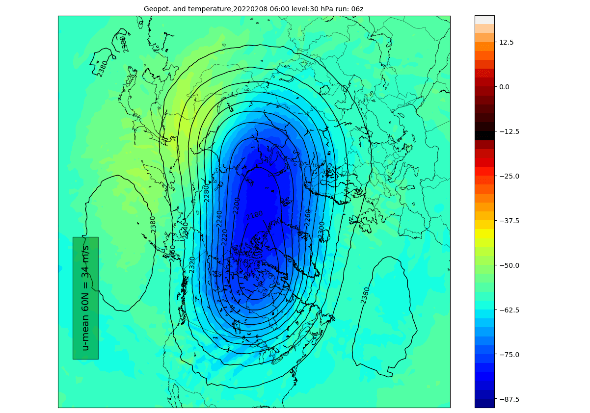
The vertical pressure anomaly profile shows that the connection between the stratosphere and the lower pressure area over eastern Canada is quite strong at this time. The marked region shows the low-pressure anomaly connecting down from the stratosphere, in the -60 to -90 latitude region, in eastern Canada.

The weather progression in this period is looking similar to the end of January, with another round of colder air coming down from the north. Spreading from the Midwest into the central and southern United States and moving towards the east. Below is the ensemble forecast, showing a likely weather scenario.

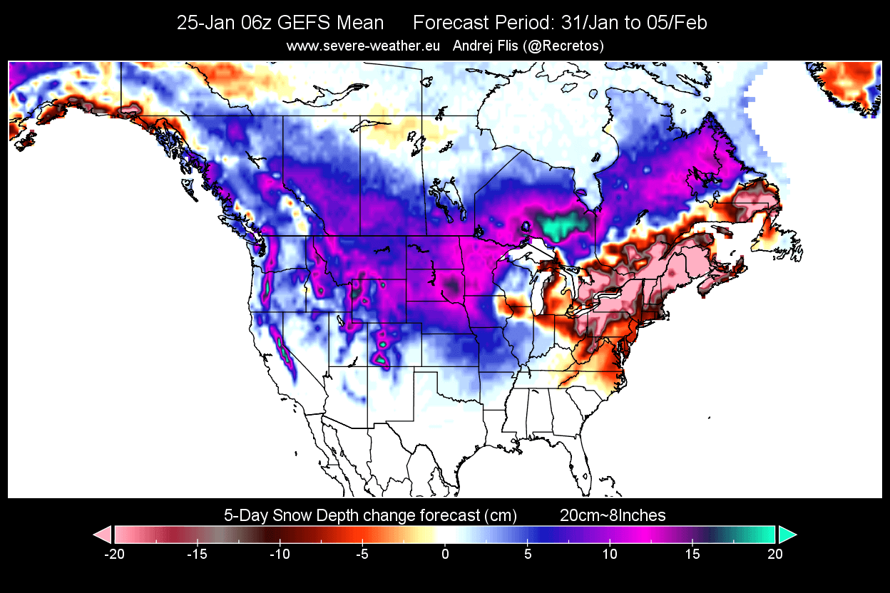
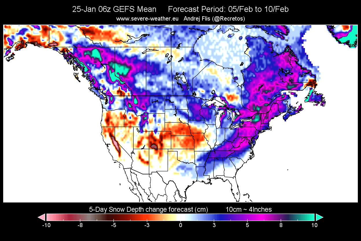
The snow depth forecast for this period shows snow depth increase over much of the eastern United States, especially in the northeast. More snowfall is also expected in the northern United States, while central states receive little to no snowfall in this northerly flow.
It is quite remarkable, how despite a strong stratospheric polar vortex, the lower level weather patterns are able to respond to it and take advantage of that power to boost the colder air transport.
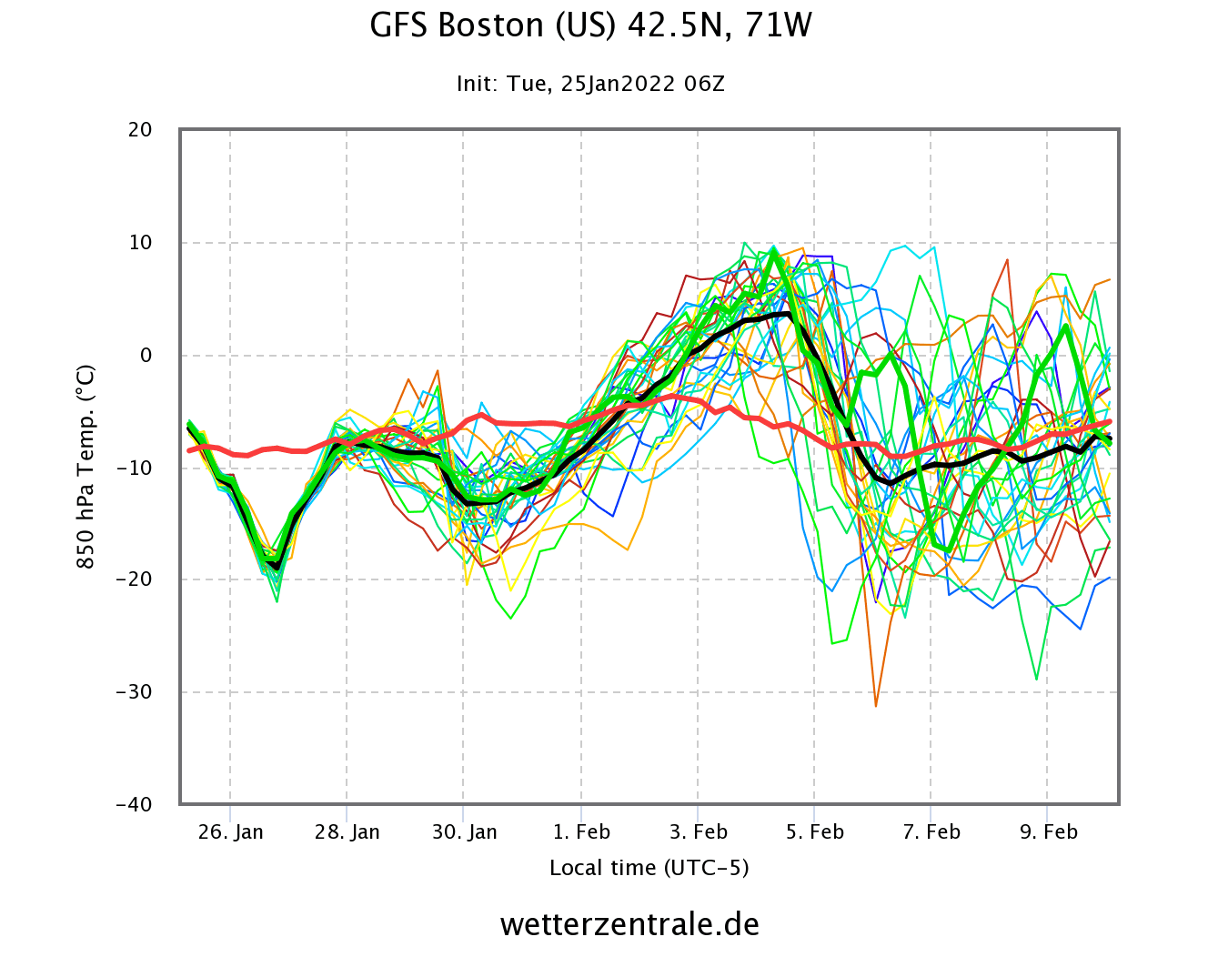
We can nicely see all this in the 16-day ensemble forecast below for Boston in the northeastern United States. The graph shows the temperature at the lower levels, where we can see the current cold air being followed by a strong warm-up in early February. It won’t last long as a cool-down is already seen behind.
The forecast for Great Falls, Montana is also remarkable, showing a strong cold outbreak early next week. That is the spread of cold air that we have shown earlier, while the eastern United States will get unusually warm weather.

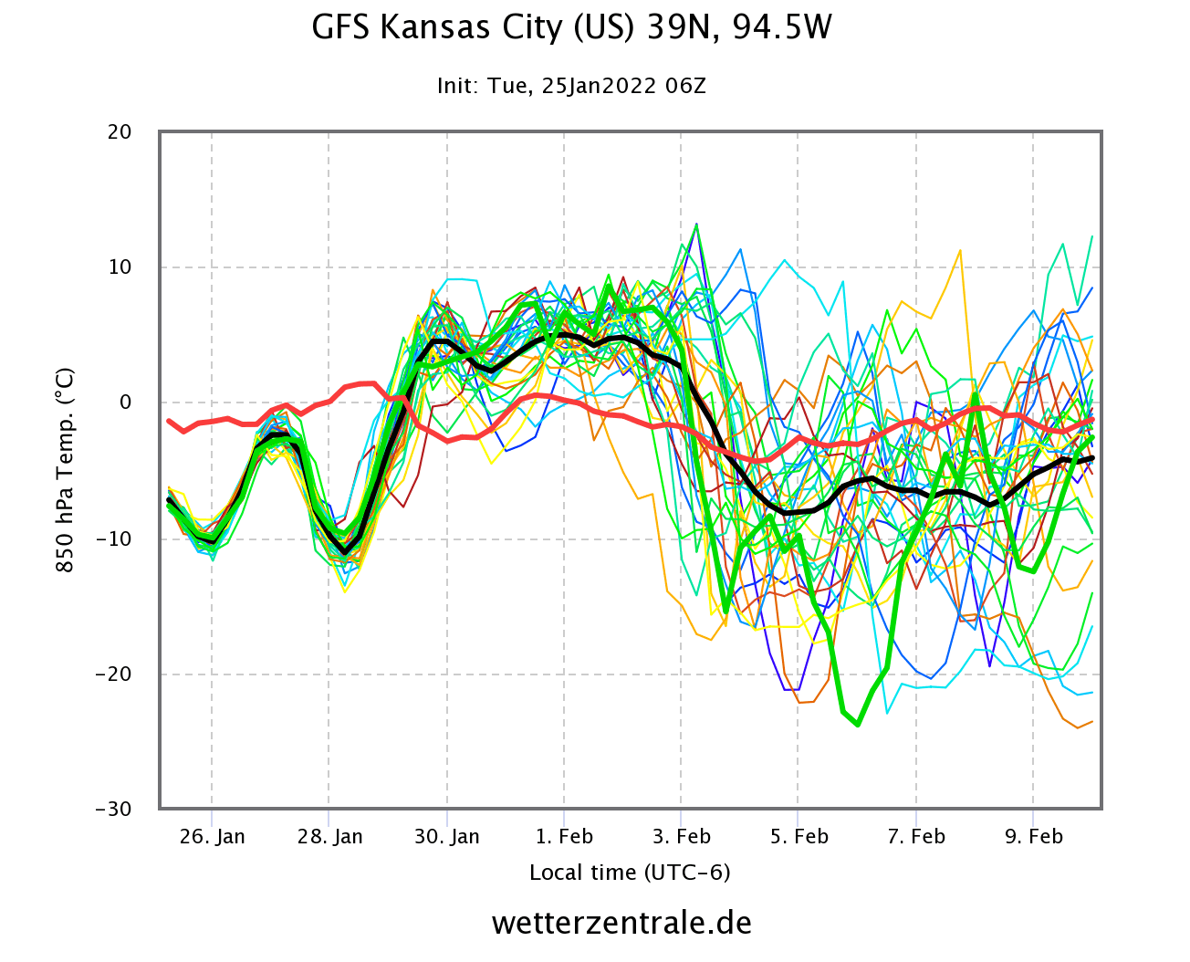
The south-central states will get a little bit of both. After the current cold period, a warmup will follow next week, interrupted by another cold wave from the north, powered by the cross-polar flow.
But things look to be stabilizing as we head deeper into mid and late February. This is the final winter month, and the first signs show that winter could be ending slightly earlier than on the calendar.
FEBRUARY POLAR VORTEX AND WEATHER
The latest extended-range forecast from ECMWF was just released, so we can look at some February trends. First, we need to look at the state of the Polar Vortex. Below is the forecast for the stratospheric polar vortex, which shows a strong character with a stable form and a warmer signal from the North Pacific.
The corresponding lower pressure pattern for early February shows the higher pressure remaining over the North Pacific and Alaska, reaching into the polar regions. A broad low-pressure zone remains over northern and western Canada, reaching into the western United States. Low-pressure also takes over the North Atlantic, building high pressure over Europe.

The temperature forecast for North America shows the colder temperatures extending into the western United States. A low-pressure area over the west usually means a warm southerly flow into the eastern half of the United States, as seen on the ECMWF forecast below.

Towards the late month, we are starting to see that the low-pressure area is closing out over eastern Canada and Greenland. This would allow a return of higher pressure into southern and eastern United States. A pattern like this can result when a strong polar vortex in the stratosphere takes over the polar circulation.
Temperature trends for this period show warmer anomalies over much of the southern and eastern United States. But this pattern however still permits occasional drop of cold air from the north, but not to a degree that it would be seen in the forecast average at this range. We see a likely extension of colder weather from the northwest into the Midwest.

As we go into early March, the sunlight returns to the North Pole, also increasing the temperature in the stratosphere. This means that the polar vortex is weakening, as the temperature difference with the south decreases. The polar vortex can slowly disappear over time or can collapse in a single strong event.

It remains to be seen how the polar vortex slows down this season. But it can have a huge impact on the weather development over the course of the spring season, so we will monitor it closely.
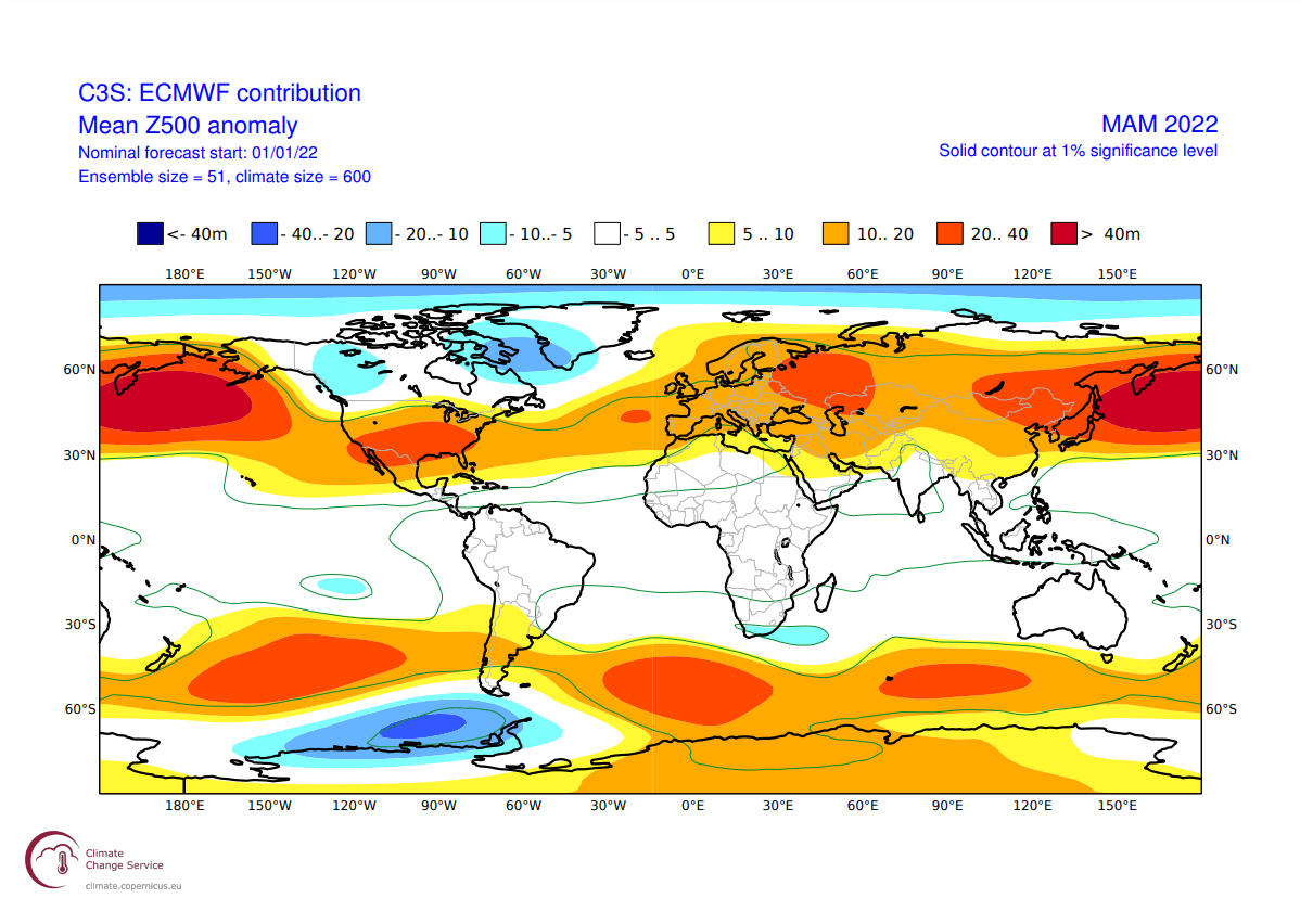
Speaking of which, we will quickly look at the first seasonal forecast trends for the spring season 2022, showing a more gradual weakening of the polar vortex.
WINTER TO SPRING SEASONAL FORECAST
We have to note, that this EMCWF data was released earlier this month, and likely does not cover any potential strong collapse event of the polar vortex.
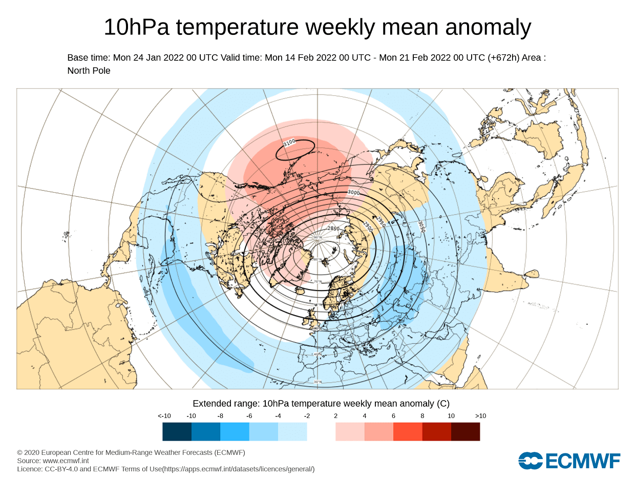
The extended range stratospheric wind forecast shows a more gradual power drop of the polar vortex as we go into early March. This is a typical seasonal weakening of the polar vortex, with little signs of a premature breakdown event. This image might look a bit different in the next few updates.
The ECMWF model is most often referred to as the most “reliable” model, at least in the long-range category. In reality, a lot depends on the individual years/seasons. But generally, the ECMWF model is at the top of the chart as far as reliability goes.
But no long-range/seasonal forecast can ever be deemed “reliable“, as we are only looking at trends and how the weather patterns are evolving on a large spatial and time scale.
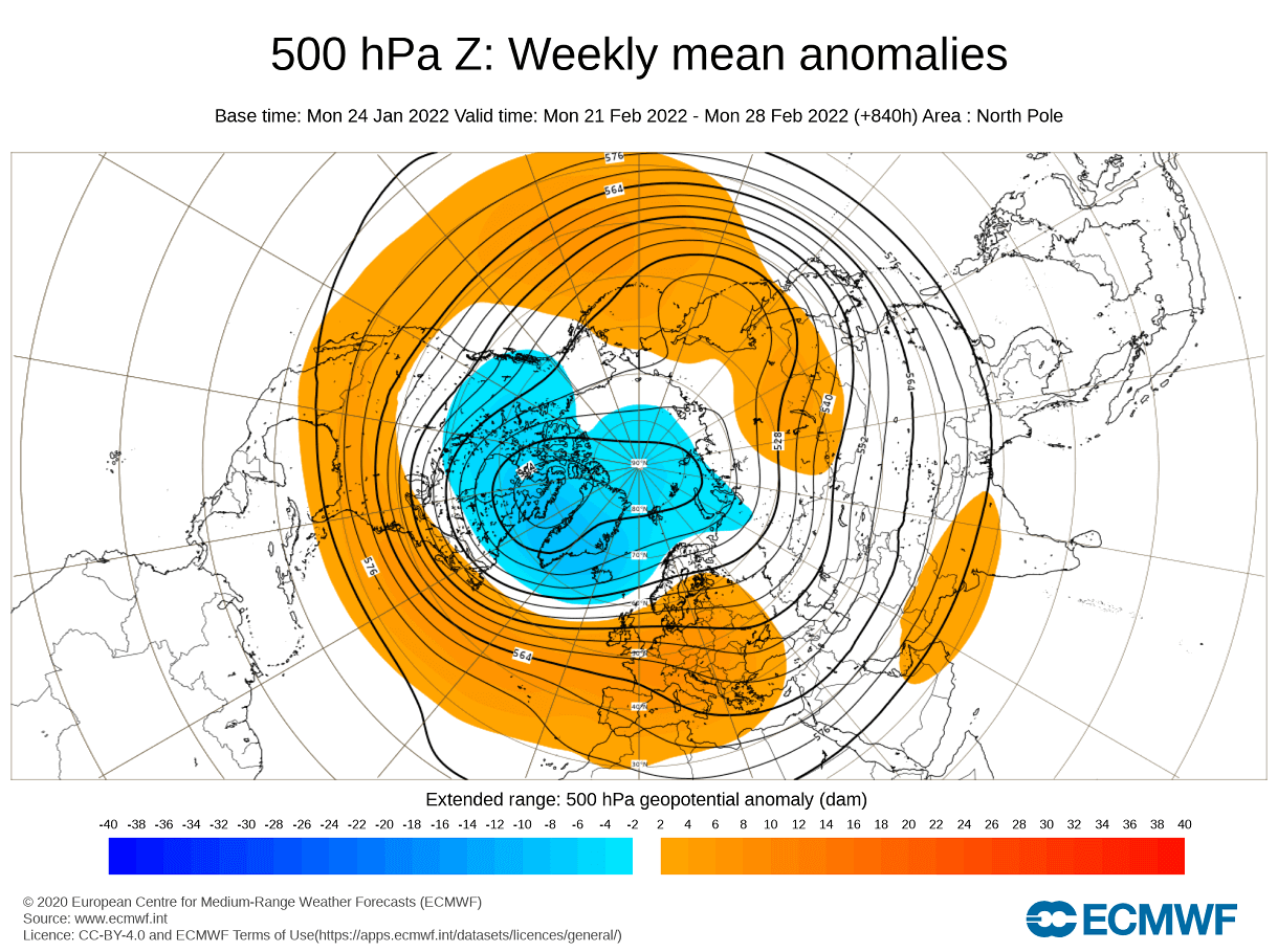
In the pressure pattern forecast from ECMWF below, we can see the typical La Nina high-pressure system in the North Pacific. The low-pressure system is present over western Canada and the Greenland area. The jet stream is bending in between the high and low-pressure systems, allowing for higher pressure in the southern United States.
We also see the North Atlantic in a positive North Atlantic Oscillation (NAO) mode, which means an amplified jet stream over the British Isles and into Scandinavia. This is a positive NAO setup, which generally means mild/warmer conditions for Europe and the southeastern United States.
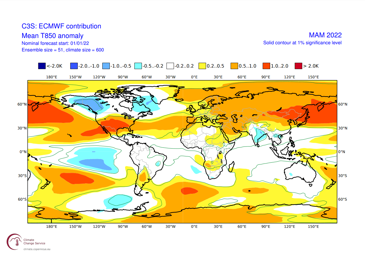
The airmass temperature forecast below shows North America divided into two parts. Western Canada is forecast to be colder than normal, and thanks to the jet stream, there is a high chance of the colder air extending into the parts of the northern United States. The Southern United States is forecast to be warmer than normal, under higher pressure.
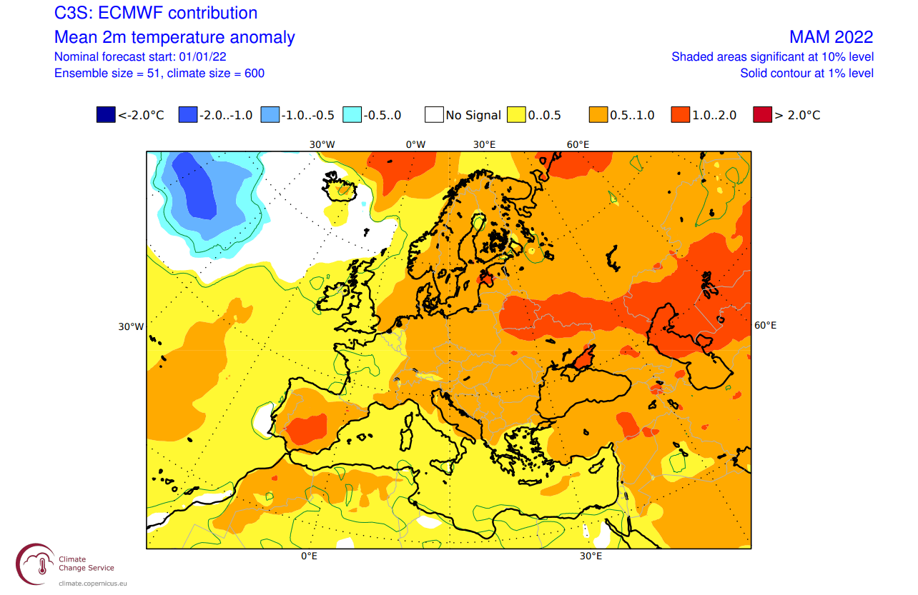
Europe also features higher than normal temperatures. A more westerly flow dominant scenario is suggested, but the pressure pattern does allow for a break in the flow. Occasional cold flow from northwest Europe is possible down into the central regions.
Looking closer at Europe, we see the surface temperatures are mostly above normal. Warmer temperature anomalies and milder conditions are more likely towards the eastern regions. Central and western regions are likely to see occasional cold fronts from the northwest during a swing in the pressure patterns.
Over Noth America, the ECMWF forecast shows colder than normal surface temperatures over much of Alaska and western Canada. We do see an indication of colder air intruding into the northwestern United States and the Midwest. Warmer than normal temperatures are forecast for the southern regions.
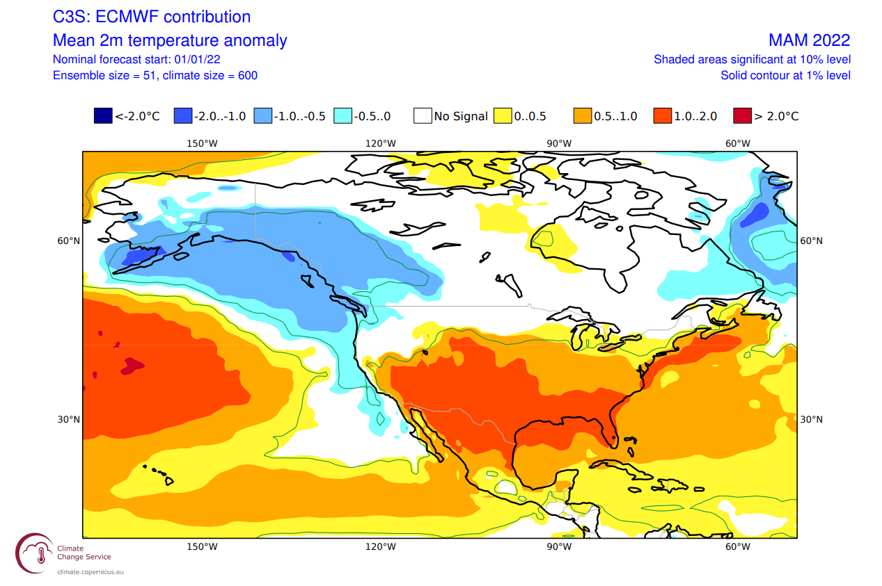
Despite being shown warmer than normal, the central and northeastern parts of the United States tend to get occasional colder weather and snow in early spring, during these patterns. As a low-pressure system progresses over the northern United States, it brings colder northerly flow into the central and eastern parts of the United States.
Looking at precipitation, Europe is expected to have more precipitation over the northern regions, where most of the low-pressure systems will be traveling. Drier conditions are forecast for western Europe, under the high-pressure zone.

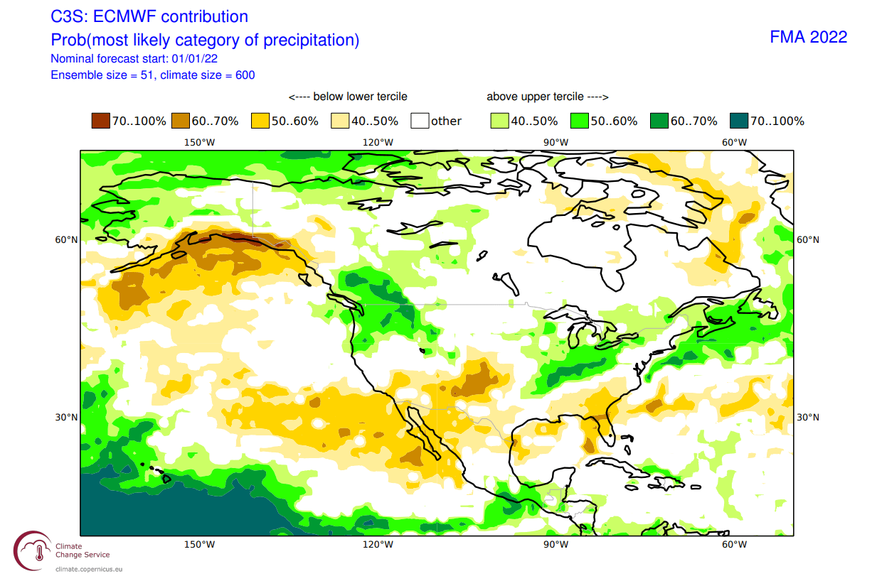
The precipitation anomaly forecast below for North America shows a classical La Nina type pattern over Canada and the United States. We see the mainland United States with wetter conditions in the northwest and the east, and drier conditions in the southwest and over Florida.
OFFICIAL NOAA SPRING OUTLOOK
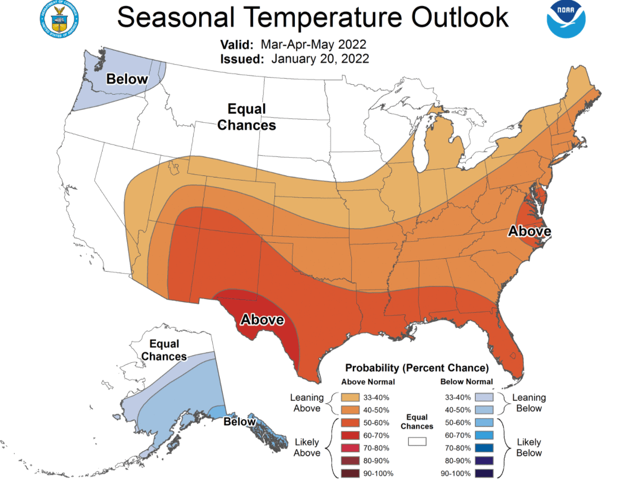
Below is the official Spring temperature forecast for the United States by NOAA. It shows the temperature probability, with colder to equal chances in the northern United States. The southern half of the country and the northeast have a higher probability of warmer than normal weather, as seen in the model forecast above.
The official precipitation forecast is also quite similar to the model forecast. We see an equal-to-higher probability for more precipitation in the northwestern and the easter United States. The southern United States is forecast to have a drier than normal spring season, especially in the southwest.
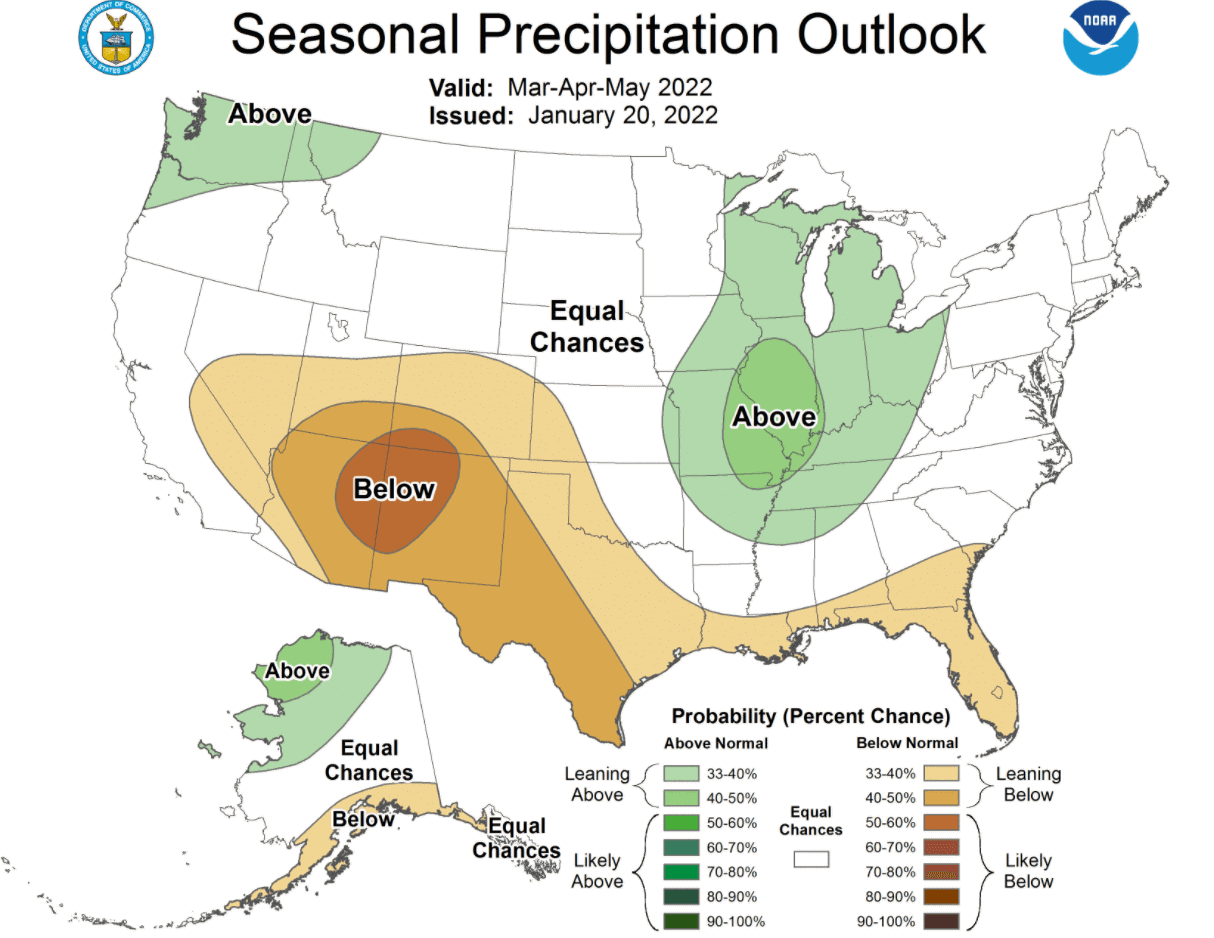
The problem with such a precipitation pattern is drought conditions in the south and southwest. Below we have the latest drought graphic from NOAA, which shows the current drought conditions in the United States.

Most of the western United States is already under some level of drought level. The driest conditions prevail in the south-central states and in the northwestern United States. Most of the eastern half of the country is currently not affected by severe drought conditions.
We will release regular weekly and monthly updates on weather development, as fresh forecasts and data are available. So make sure to bookmark our page, and also, if you have seen this article in the Google App (Discover) feed, click the like button (♥) there to see more of our forecasts and latest articles on weather and nature in general.
SEE ALSO: