A Polar Vortex collapse event is starting in the stratosphere, with the Polar Vortex splitting apart and breaking down. This event will push the Polar Vortex beyond the point of recovery, terminating it until the next cold season. The collapse event will translate into the weather patterns in the coming weeks.
The Polar Vortex is a very powerful short-to-medium term weather driver during the cold season and into spring. It has a strong connection all the way from the ground up into the higher levels of the atmosphere.
For this reason, it is crucial to monitor the activity high above in the stratosphere. Currently, the Polar Vortex has begun a strong collapse event down from the higher levels of the atmosphere.
First, we will quickly and simply learn what the Polar Vortex really is and why is it so important. Then we will analyze the latest development and break down the weather changes relating from the Polar Vortex collapse, into April and towards the Summer 2022 season.
NORTH HEMISPHERE POLAR VORTEX
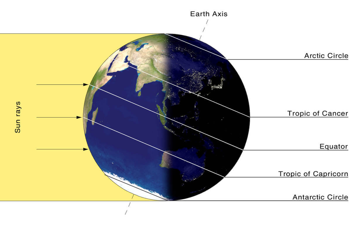
Every year as we head into autumn, the polar regions start to receive less sunlight. This way, cooling begins over the north pole.
But as the polar temperatures drop, the atmosphere further south is still relatively warm as it continues to receive light and energy from the Sun.
You can see the winter solstice in the image below. The polar regions receive little to zero solar energy, compared to regions further south, which still continue to receive plenty of sunlight and energy.
But, as the temperature is dropping over the polar regions, so is the pressure. With colder temperatures over the pole, the temperature difference towards the south increases.
This also causes a strong global pressure difference, and a large low-pressure (cyclonic) circulation starts to develop across the Northern Hemisphere. It extends from the surface layers, far up into the stratosphere. This is known as the Polar Vortex.
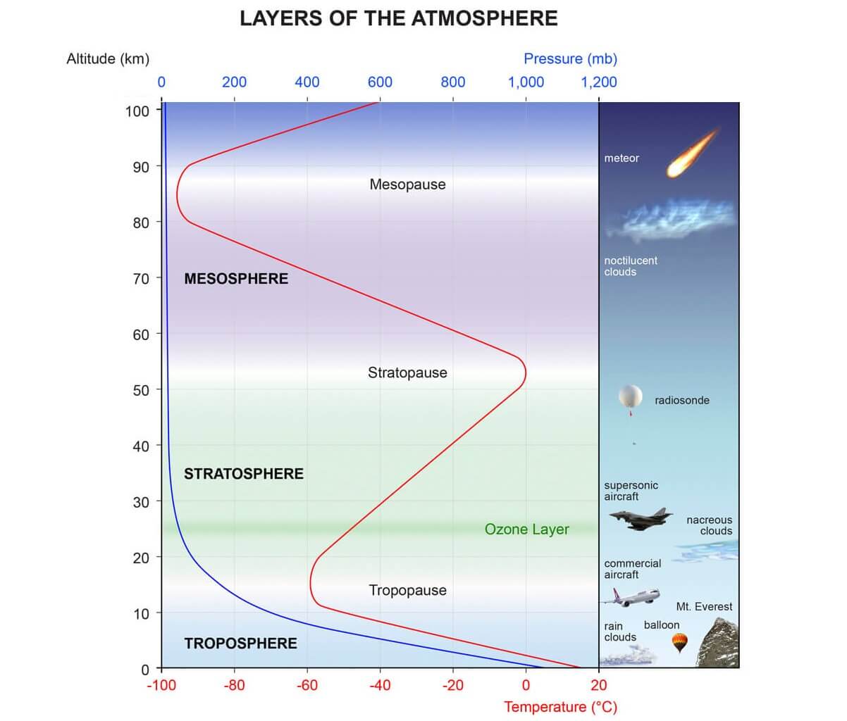
You can see the layers of the atmosphere in the image below. The troposphere (blue layer) and the weather are on the bottom and the stratosphere (green layer) with the ozone layer above it.
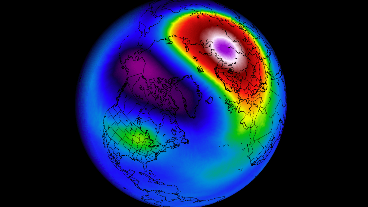
The image below shows a typical example of the peak strength Polar Vortex at around 30km/18.5miles altitude (10mb level) around the middle stratosphere during the winter season.

It is behaving like a very large cyclone, covering the whole north pole, down to the mid-latitudes. It has a strong presence at all levels, from the ground up, but can have different shapes at different altitudes.
In the next image below, we have the polar vortex at a much lower altitude, around 5km/3miles. The closer to the ground we go, the more deformed the polar vortex gets because it has to interact with the mountains and overall terrain and also with the strong weather systems
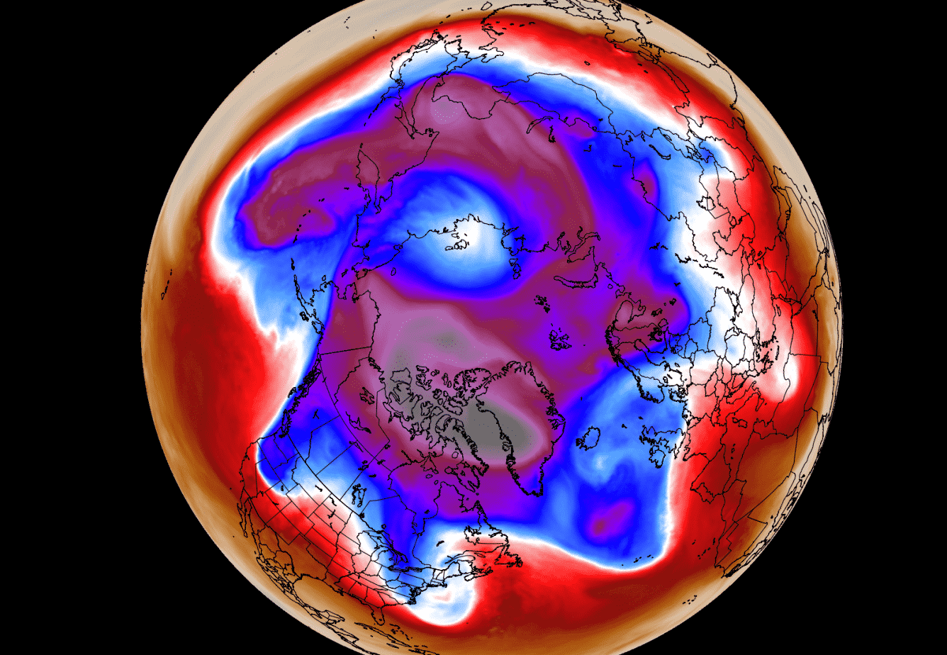
Be aware of its “arms” extending into the lower latitudes, bringing along colder air and snowfall. These arms also pack a lot of energy and can create strong winter storms, like a Noreaster’ in the United States or powerful wind storms in the North Atlantic.
We are typically focusing more on the Stratospheric Polar Vortex, as it plays a very important role in the weather development throughout the season. It is known for its strong influence down from the stratosphere.
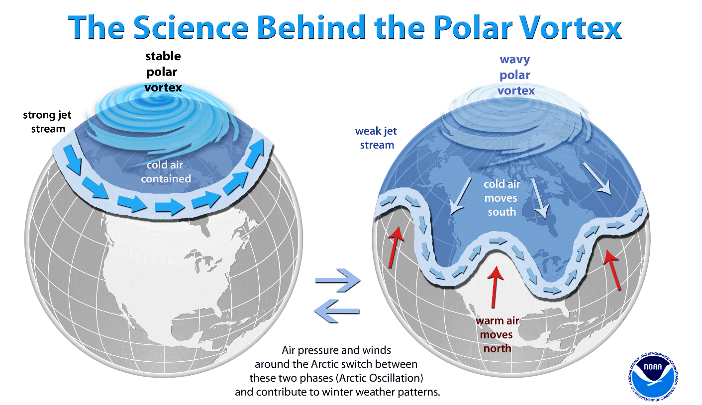
A strong Polar Vortex usually means strong polar circulation. This usually locks the colder air into the Polar regions, creating milder weather for most of the United States and Europe.
As a contrast, a weak (wavy) Polar Vortex can create very dynamic weather. It has a much harder time containing the cold air, which can now escape out of the polar regions, into the United States and/or Europe. Image by NOAA.
Typically, a polar vortex circulation is disrupted due to a rise in temperature in pressure in the stratosphere. That is called a Sudden Stratospheric Warming (SSW) event, which collapses the Polar Vortex.
But there can also be smaller warming waves in the stratosphere, that do not collapse the polar vortex. Instead, they can sometimes displace or disrupt the polar vortex enough to weaken its influence on the surface levels.
To put the Polar Vortex into a perspective, we produced a high-resolution video, which shows the upcoming collapse event of the Polar Vortex.
Video shows the 10mb level (30km/18.5miles) forecast from the GFS model. We can see the quick overview of the Polar Vortex first being split apart, followed by a strong displacement and weakening.
The main takeaway from the video should be that the Polar Vortex is not just one single winter storm or a cold outbreak that moves from the Midwest into the northeastern United States.
It is one large cyclonic area that is spinning over the entire Northern Hemisphere, from the ground up to the top of the stratosphere and beyond, reaching over 50km/31miles in altitude.
WINTER POLAR VORTEX ENDS
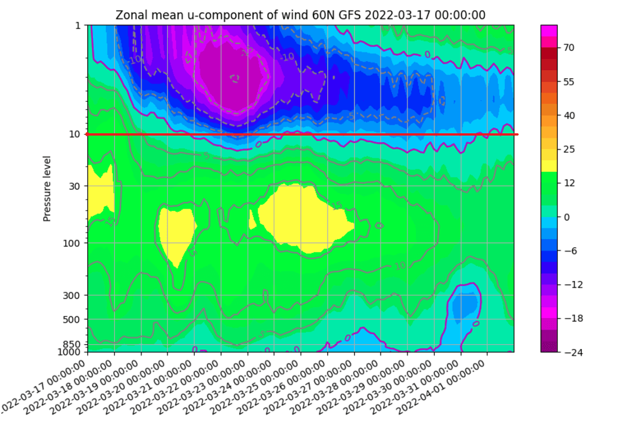
We typically use the 10mb level, when analyzing the polar vortex in the stratosphere. That is around 28-32km (17-20 miles) in altitude. This layer is considered to be in the mid-stratosphere and is a very good representation of the general strength and status of the stratospheric polar vortex.
The strength of the polar vortex is most often measured by the power of the winds that it produces. This is typically done by measuring the westerly zonal (west to east) wind speeds around the polar circle (60°N latitude).
On the image below we have the seasonal average zonal wind speed for the Polar Vortex at 10mb level. The black line is the long-term average, and the blue line is the polar vortex strength in the 2021/22cold season. We can see that for most of the cold season, the polar vortex was stronger than normal.
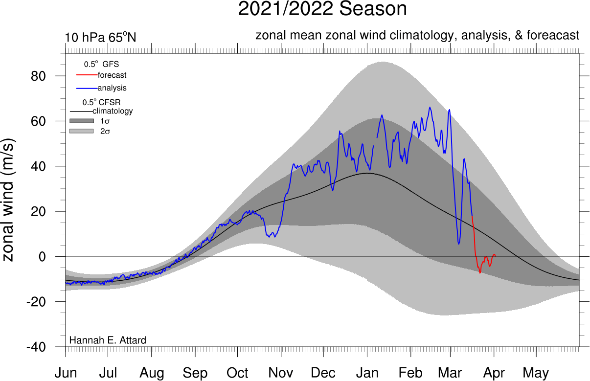
But the red line is the forecast, which shows the rapid weakening of the polar vortex is coming in the next few days. When the zonal (westerly) winds are reduced below zero in a sharp/rapid event, that is considered as a breakdown of the circulation.
Looking closer at the forecast part, we have the GEFS ensemble forecast below. It shows the fast reduction of the westerly (zonal) winds speeds in the stratosphere, as the polar vortex breaks down and gets displaced from the North Pole.

But not just winds, the temperature is also of major importance. The colder the polar vortex gets, the stronger it is, producing also stronger winds. Below we have the 2021/2022 season analysis of the stratospheric temperature at 10mb from NASA.

The red/violet line is the 21/22 season, which shows the colder than normal polar vortex at the 10mb level in the stratosphere. But recently we can see a temperature increase. Especially in the forecast part (orange), it will reach near all-time highs. This is the now starting stratospheric warming event.
Of course, colder temperatures and stronger winds mean lower pressure. And we can ee just that if we look at the bigger picture.
The next image below shows pressure anomalies from the surface into the upper stratosphere over the winter season.
You can observe the strong low-pressure buildup in the stratosphere in late November. That was a strong polar vortex, connecting down to the surface levels in early December. It got even stronger in 2022 but was having a hard time connecting down to the surface.

Strong high-pressure systems were/are pushing back against the stratosphere, “disconnecting” the upper and the lower polar vortex far into February and now in March.
We are now going to look at what exactly is going to happen up in the higher levels of the atmosphere, and just how it is set to influence our weather for weeks to come.
STRATOSPHERIC BREAKDOWN EVENT BEGINS
A Polar Vortex collapse event does not “just happen”. This is a very energetic process with a delicate chain of events, driven by the clash of strong pressure anomalies.
As these strong pressure systems interact with each other, they can exert a lot of energy upwards into the stratosphere. This is a very well-known process, also called “vertical wave activity”.
On the image below you can see the vertical wave activity example. First, we have strong weather systems that deflect energy upwards into the stratosphere. Later, that energy can disrupt the circulation, creating a warming event and collapsing the polar vortex.
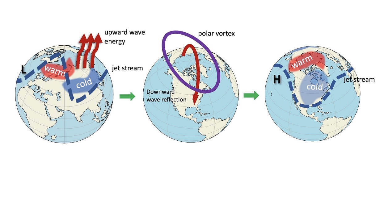
The collapsed polar vortex then sends the energy back down, changing the surface weather patterns by altering the jet stream location.
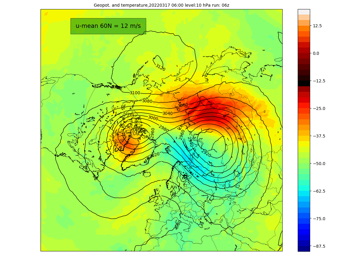
Looking at the current polar vortex status, we can see that the vortex is already under pressure from the European and the North Pacific sector. It has an oval shape, and we can already see the separation in its core, creating two centers.

Taking a look at the temperature profile at the 10mb level (30km/18.5mi), we can see a warming wave developing over eastern Siberia and a weaker one over northern Canada. Here we can also see the separation of the core into two entities.
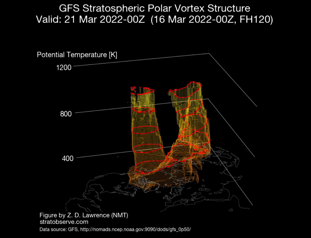
The separation can be also seen below on the 3D structure of the polar vortex. The vortex is elongated, developing two cores. You can imagine this process as squeezing a balloon, developing two “bulges”

The vertical pressure anomaly profile reveals a connection between the stratosphere and the lower levels. We can observe the stratospheric low-pressure areas already separated into two cores. Two strong high-pressure areas are present around, pressing weakening the polar vortex.

The source of energy is of course coming from below. We can see the latest analysis of the energy transfer from the lower levels up into the stratosphere in the image below. It shows a strong thermal energy exchange at around 16km/10miles altitude (lower stratosphere).

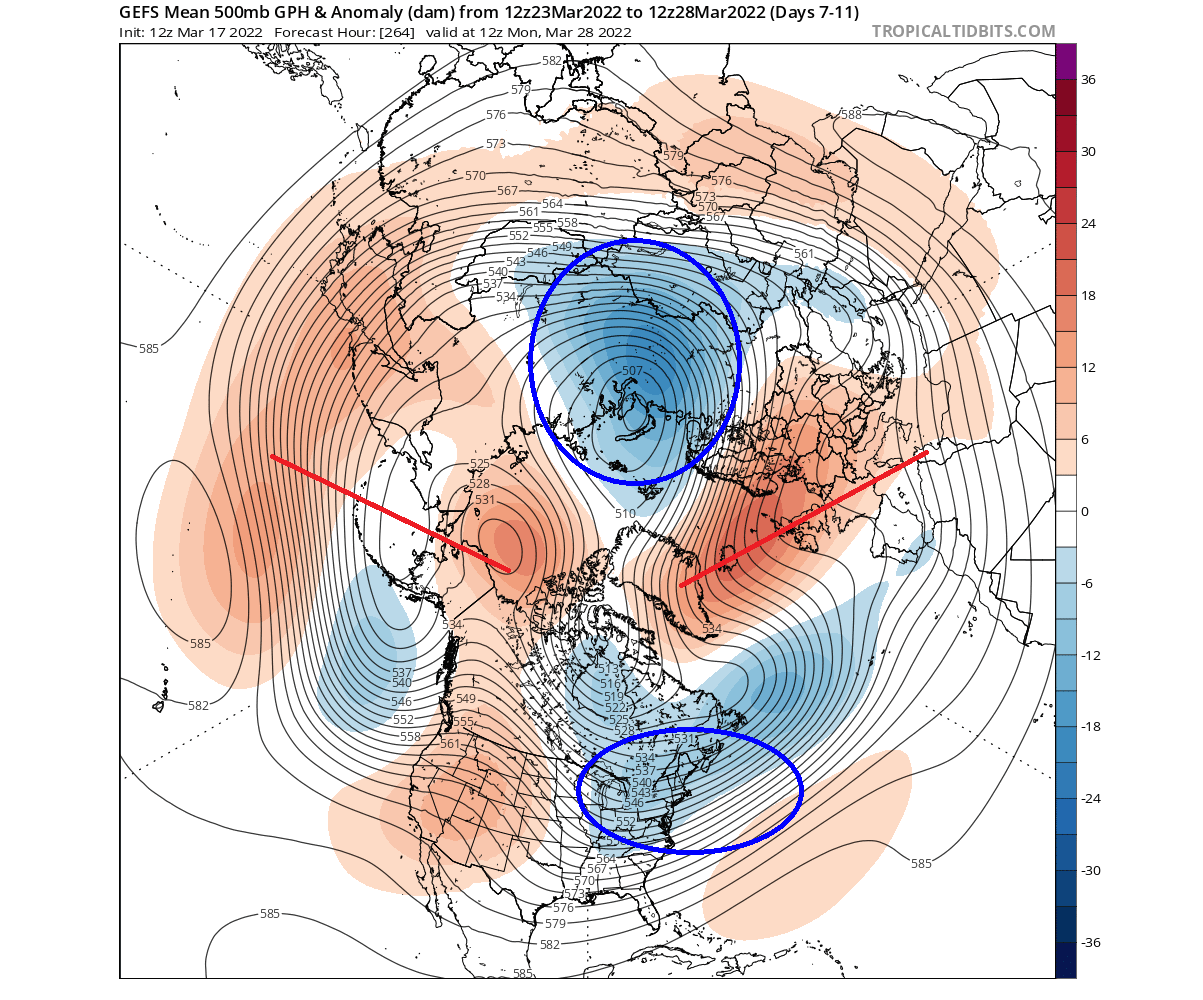
We can nicely see the strong pressure system interaction across the Northern Hemisphere on the 5-day forecast below. These marked areas are showing a strong Rossby wave development, releasing a lot of energy up into the stratosphere.
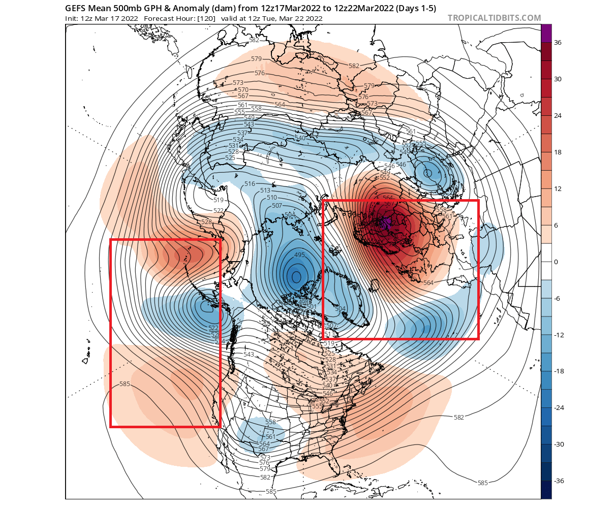
At the same time, these patterns are also defining our current weather. A strong blocking high will remain over northern Europe, with a low-pressure system moving over the southern United States in the coming days.
This translates into warmer anomalies over northern Europe under high pressure. But the low-pressure system over the southern United States is driving up warmer weather into the eastern half of the country, and colder air in the west behind.

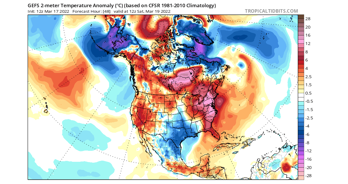
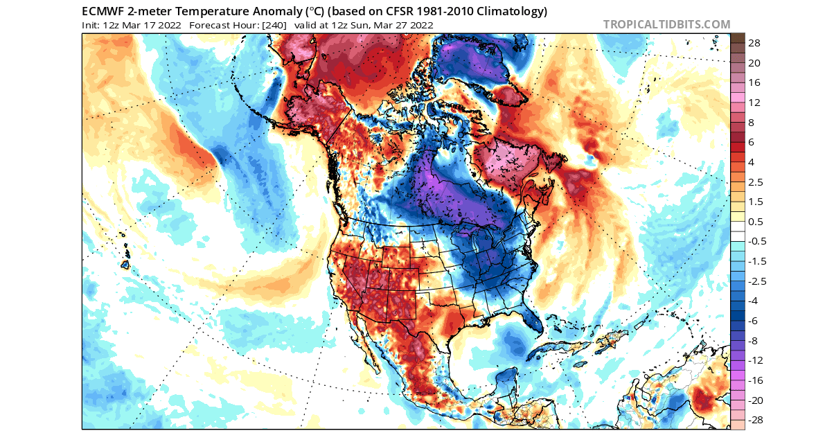
Taking a closer look at the end of this period over North America, we can see the colder than normal temperatures over the south-central United States. Most of the eastern and northeastern United States is under unseasonably warmer weather.
STRATOSPHERIC POLAR VORTEX COLLAPSE
Going ahead into the late week, we can see strong high-pressure in the stratosphere over North America, extending over the North Pople and splitting the Polar Vortex apart fully. The cores are detached at this point, and the circulation is reversed.
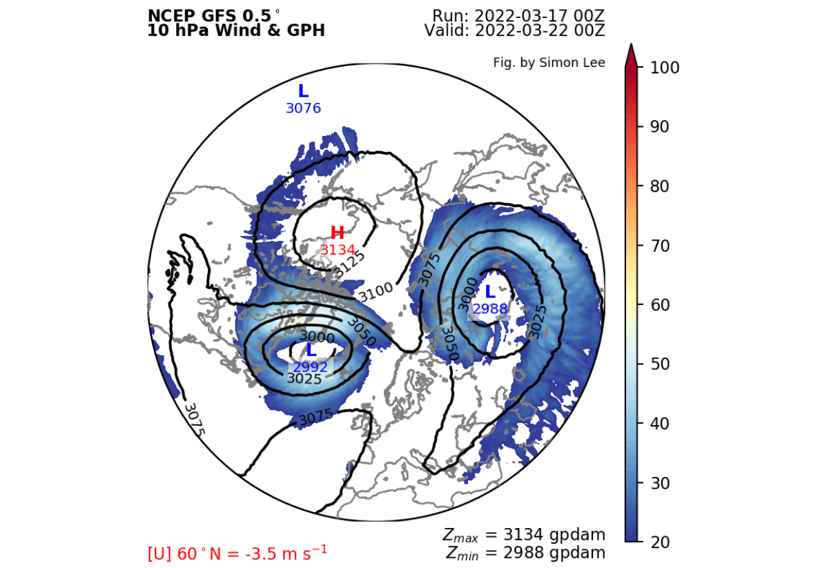
Looking at the temperature profile at this level, we can see a strong warming wave coming together around both cores, merging over the Polar regions. Here we can also see the cores separated, and the stratospheric warming event taking over.

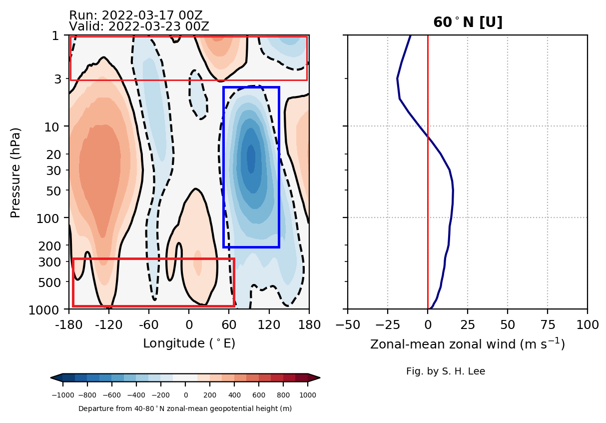
On the vertical pressure anomaly profile, we have the best view possible, of the collapsed structure on the top of the stratosphere (top red box). The remaining main core is over Siberia (blue box) in the mid to low stratosphere. But in the lower levels, the circulation is also very disturbed.
This is best seen in the 3D structure forecast below. The Polar Vortex is clearly separated on all but the lowest levels. Cores are fully detached and losing energy.
Speaking of the lower levels and the weather, we can see on the pressure pattern forecast below, that the main cores are also detached. The circulation is still there around the hemisphere, but the main pressure centers are separated. Two strong ridges are splitting the pattern apart.
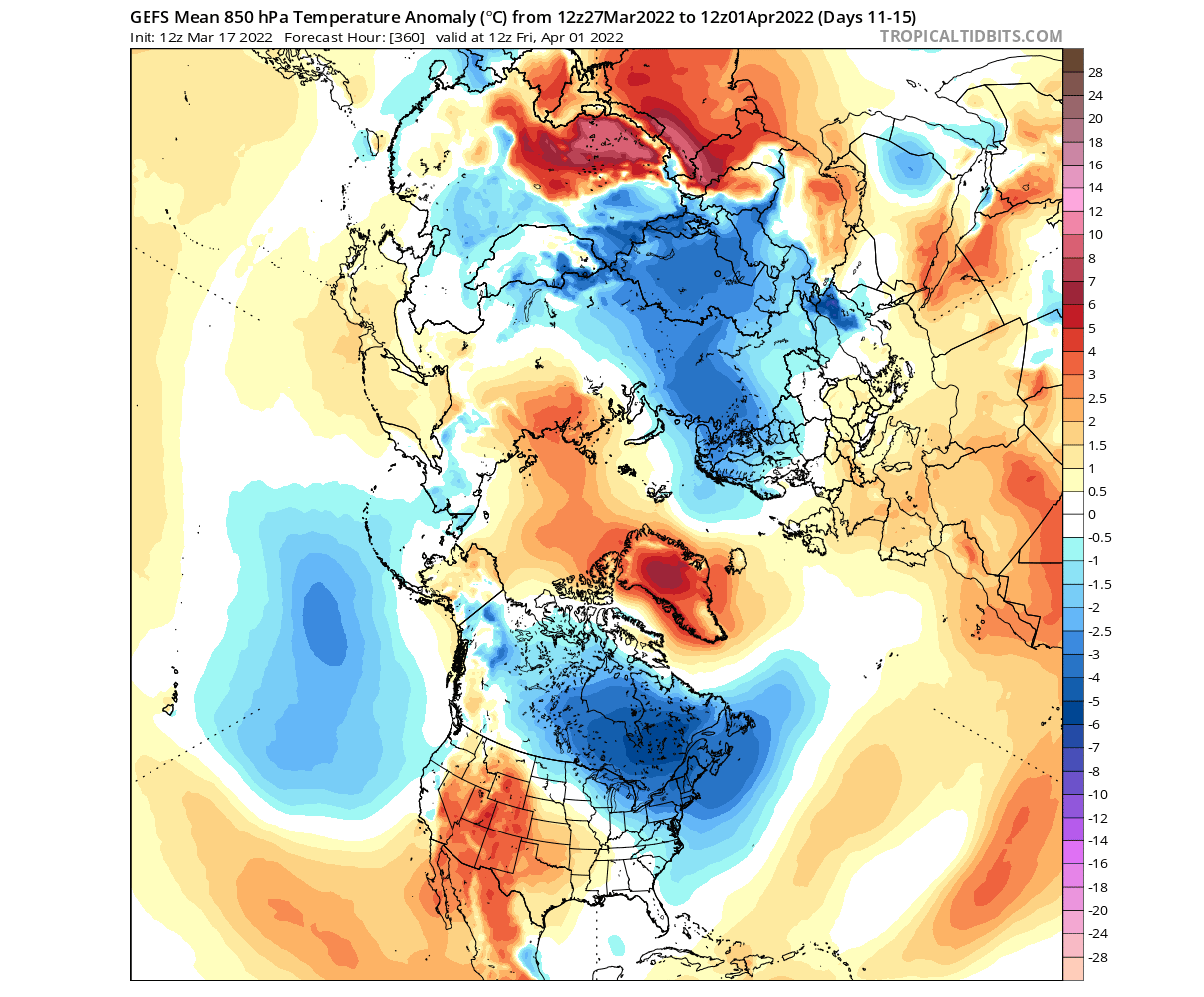
The temperature forecast for this period shows the cold air following the two cores out, into North America and into Siberia. This wave of colder than normal air will extend down into the eastern United States later next week.

Looking closely at this period, we can see the colder air spilling down from Canada into the Midwest, over the Ohio Valley down to the southeastern states.
NOAA OFFICIAL 8-14 DAY WEATHER OUTLOOK
This is all nicely captured below on the official NOAA/CPC 8-14 day forecast for the United States. Colder than normal temperatures will prevail over much of the eastern half of the country. Warmer temperatures will return in this period to the western half, under the influence of a high-pressure system.
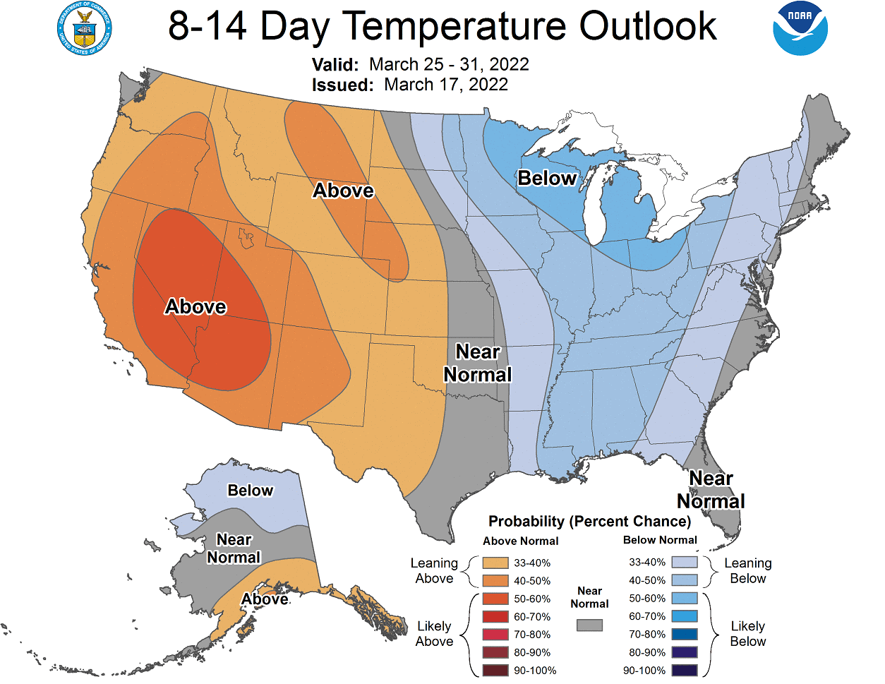
Looking at the official NOAA precipitation forecast, we have a signal for more-to-normal precipitation over the northern and northeastern parts of the United States. Less precipitation is expected under the drier cooler northerly flow in the southeast, and under the stable high-pressure in the southwest.

POLAR VORTEX DISINTEGRATES
Below we have a wind speed forecast for the atmosphere up to around 50k/31mi altitude. We can see strong easterly (negative) winds coming down as the Polar Vortex collapse. This nicely shows the collapse sequence, coming from the top down. In the lower levels, we can also see negative winds as the pattern is disrupted.
In the next graphic below, we have the pressure anomalies in the atmosphere shown over time in the Northern Hemisphere. Higher numbers (blue colors) mean low pressure and stronger polar vortex strength.

Here we can also nicely see the strong high-pressure forcing down from the upper layers of the stratosphere. In the later stages of the forecast, there are early hints of a direct connection with the lower levels. This is yet to be resolved in the coming days.
Going into early April, we can now see the high-pressure system in the stratosphere completely taking over the western hemisphere. Winds are still reversed, with the remaining weak core of the Polar Vortex being pushed over into Siberia.
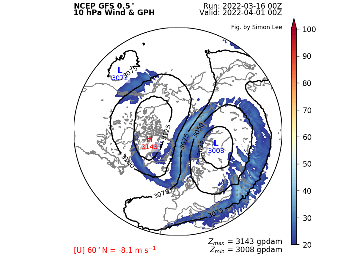
At this point in time, the temperatures are steadily increasing over the North Pole, as the Sun has returned and is getting stronger each day. That means that there is “no way out” for the remaining core of the vortex, as rising temperatures help to raise pressure.
Looking at the temperature profile of the 10mb level (30km/18.5mi), we can see that the cold cores are gone. Warming has engulfed the remains of the Polar Vortex, keeping at neutralized, and keeping it from re-organizing.

We can see on the 3D structure what is left of the main Polar Vortex structure. Its remains are confined to the lower levels, with the upper circulation pretty much collapsed. This marks the end of the stratospheric Polar Vortex until the next cold season starts in Fall.

The vertical pressure anomaly profile reveals the disrupted structure on the top of the stratosphere and in the lower levels. In the mid-low stratosphere, a weak anomaly remains, getting weaker over time, as temperatures keep rising in the stratosphere.

Looking at the lower pressure pattern forecast in early April, we can also see a pretty broken down core structure of the lower polar circulation. The main core elements are focused on northern Europe, eastern Canada, and a non-related low system in the North Pacific.
The high-pressure ridging is still connected over the Polar Circle, keeping the circulation in a disturbed state.
Looking at temperature anomalies for this period, we can see the colder air following the core sections into Scandinavia and Siberia, and into Canada and the northeastern United States. Most of western and central Europe is warmer than normal under a ridge.
Looking closer at North America, we have an example forecast below, showing a possible scenario. The idea is that the low-pressure system over eastern Canada pulls down colder air on its western side with the northerly flow.

The colder air would have a chance to spill into Midwest and into the entire northeastern United States.
As seen on the snowfall forecast below, the air is of course still cold enough to allow snowfall. In the forecast, we can see a swath of snowfall from the Midwest towards the east.

We do have to repeat, that this is far out in the forecast period, so it serves as an example of a possible scenario. The ensemble forecast supports the disrupted circulation, which is supportive for further cold air intrusions into northern and northeastern United States.
Further down we will cover the early weather trends for April, and after that we will look at the seasonal weather into early Summer.
APRIL WEATHER PATTERN
The latest extended-range forecast from ECMWF was released on Thursday, so we can look at some April trends. First, we need to look at the leftover state of the Polar Vortex.
Below is the ECMWF extended-range forecast for the stratospheric polar vortex, which shows the current collapse event. But following this event, we do not see the Polar Vortex recovering, making this a final warming sequence.

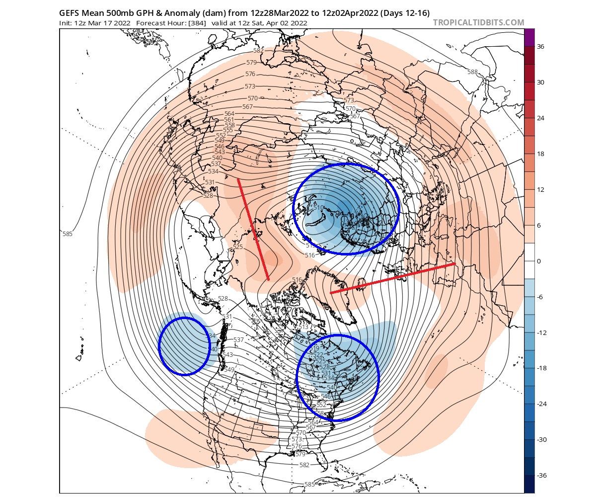
The pressure pattern forecast for mid-April shows the higher pressure remaining over the Polar Circle. A broad low-pressure zone remains over Siberia and a weaker one over western Canada and the United States.

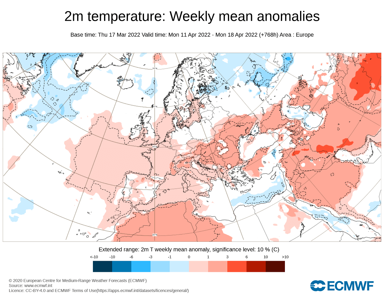
Looking at the temperature forecast for Europe in the same period, we can see mostly warmer than normal temperatures. Colder than normal air is likely to extend from northeastern Europe down into north-central regions.
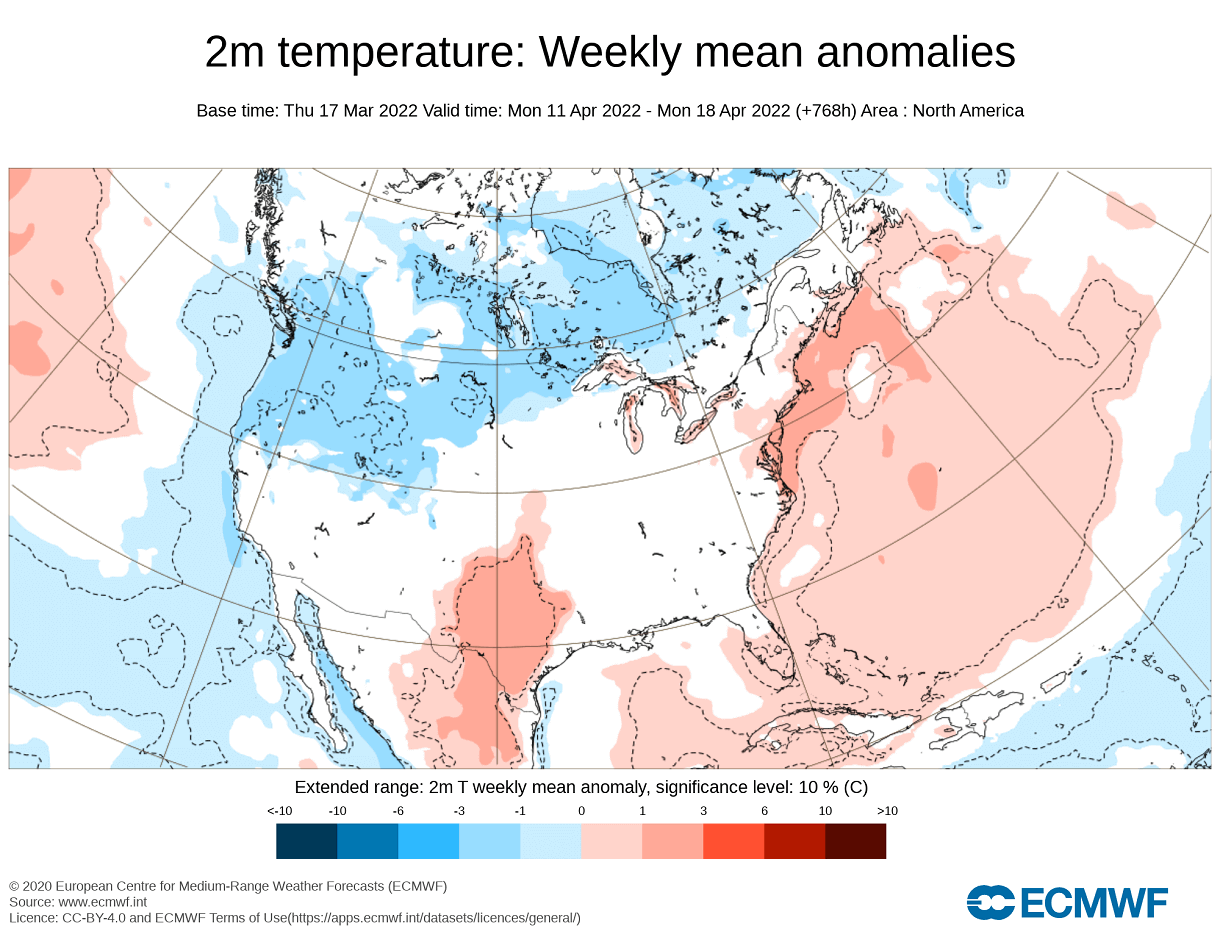
The temperature forecast for North America shows the colder temperatures extending over most of Canada and the northwestern United States. A low-pressure area over the northwest usually means a warmer zonal (westerly) flow into the southern half of the United States and parts of the northeast.
NOAA/NCEP releases regular monthly forecasts, produced by their CFS model. Below is the temperature anomaly forecast for the whole month of April over North America. We can see that it differs from the ECMWF extended-range above.
The main reason is likely that the CFS is not handling the Polar Vortex collapse event very well. It still shows colder to normal temperatures over much of the northern United States. But it is much warmer in Canada.

Precipitation-wise, we can also see wetter conditions over most of the northern half of the United States. The southern half of the country will be drier, with significant drought conditions likely for the southwest.

We will quickly look at the latest long-range forecast trends below, extending our look at the weather trends in the upcoming months.
SPRING TO EARLY SUMMER WEATHER OUTLOOK
We will be using the ECMWF long-range model (SEAS-5), as it is often referred to as “the best” model for long-range forecasting.
The forecast period we will be focusing on is April-May-June (AMJ 2022). This period covers two remaining months of meteorological spring and the first month of meteorological summer.
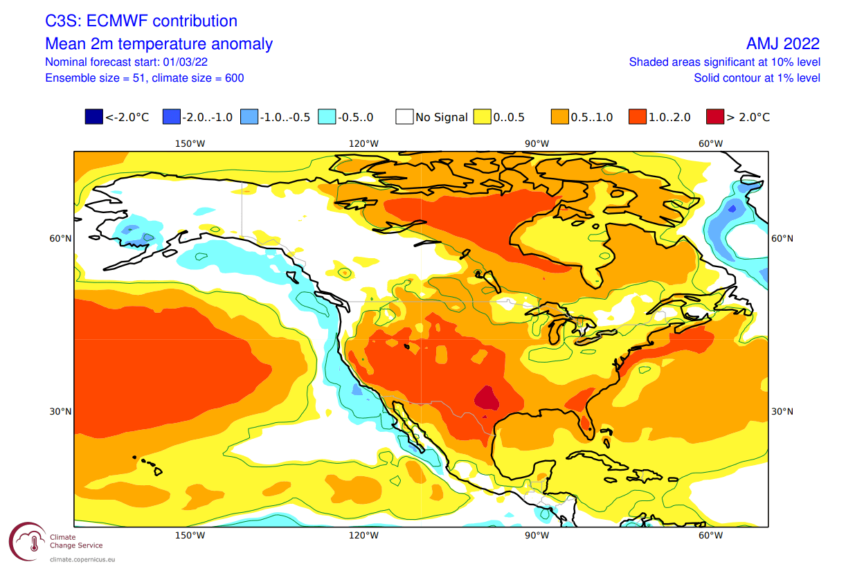
In the pressure pattern forecast from ECMWF below, we can see a strong La Nina high-pressure system in the North Pacific. A low-pressure system is still indicated over western Canada. Another broader low-pressure area is over the eastern Polar regions.

That low-pressure area is likely there also as a result of the stratospheric dynamics, displacing the main polar core circulation into the eastern hemisphere. In contrast, we have a strong high-pressure area over most of Europe.
The global temperature distribution is partially similar to the past winter patterns. Over North America, we see indications of colder temperatures over western Canada and Alaska, transitioning down into the northwestern United States. The southern United States is forecast to be quite warmer than normal.

Europe features mostly warmer than normal conditions, with a storm track further to the north from the North Atlantic into northern Scandinavia.
Looking closer at Europe, we see warm anomalies over most of the continent. The pattern that ECMWF suggests, does leave the door open for cooler northerly flow from the northwest into parts of Central Europe.

Over North America, we see the neutral area extending down from Canada further into the northwestern United States. This is the most likely area to see colder than normal temperatures. But we also see a weaker warm anomaly area in the Midwest and the northeastern United States.
Warm anomalies are a certainty for the southwestern United States. The pressure pattern that the ECMWF shows for the southern United States is also in agreement with other seasonal forecasts, thus deemed a “higher reliability” scenario.
The precipitation forecast shows the drier conditions over most of the western United States. But parts of the eastern United States have a higher chance of wetter conditions. Europe features higher precipitation over northern regions, due to the higher frequency of low-pressure systems moving over this area.

This raises concerns for severe drought conditions over the south and especially the southwestern United States. The drought conditions are already present strongly over the west and south, as seen on the analysis below by the United States national drought monitor service.

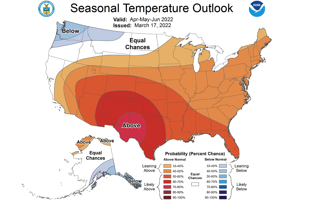
Looking at the NOAA official temperature outlook, colder to normal forecast prevails in the northwestern United States. The southern and eastern United States have a higher probability of warmer than normal weather, as seen in the model forecast above.
The official precipitation forecast is also quite similar to the model forecast. We see an equal-to-higher probability for more precipitation in the Midwest and the Ohio Valley. Most of the western United States, however, is forecast to have a drier than normal season towards summer.

We will release regular weekly and monthly updates on weather development, so make sure to bookmark our page, and also, if you have seen this article in the Google App (Discover) feed, click the like button (♥) there to see more of our forecasts and latest articles on weather and nature in general.
SEE ALSO:
A new Dangerous Severe Weather and Tornado Outbreak for the South and Southeast U.S.