November is the last Autumn month and the very important stepstone towards winter. We will take a look at the November weather development over the weeks and how it might transition into winter.
We will take a weekly approach, breaking down the month into weekly periods, looking at the pressure patterns and the corresponding weather and temperature distributions.
Since this period is over 30 days long, we will be using the ensemble forecast system. This means that the forecast is composed of several individual calculations. The final forecast is an average of all the calculations, showing the prevailing idea and the main trend.
The monthly forecast is not meant to determine the temperature at a city in Germany or Texas at 12:30 pm for example. That is only for a couple of days in advance. The monthly forecast is only to look at large scale weather patterns across the entire Northern Hemisphere, and how it may influence the weather on a continental scale.
NOVEMBER WEATHER – WEEK 1
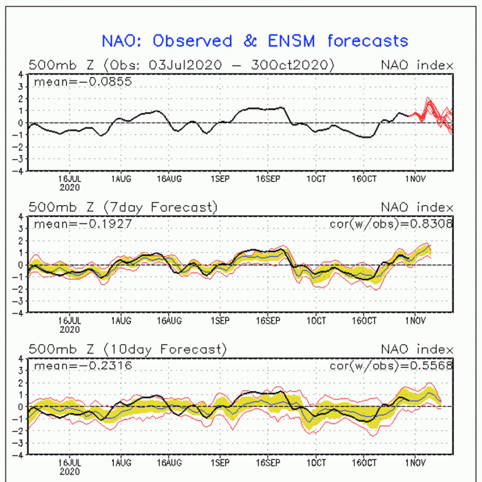
The November weather pattern will begin with a rather classic positive North Atlantic Oscillation (NAO). That means lower pressure around Iceland and Greenland, and higher pressure towards the south. On the image below we have a partially positive NAO as the high-pressure area is reaching quite far to the north.
Most of Europe is also under higher pressure, with a frontal passage over northwestern Europe and central Europe. Behind the cold front, a stronger area of higher pressure will expand over the continent.
Over North America, the pattern will be in transition, as a lower pressure system over the eastern United States will move out into the Atlantic. But the main energy will retract to Canada, amplifying the westerly flow over the United States. A high-pressure area will expand over the continental United States, along with warmer weather.
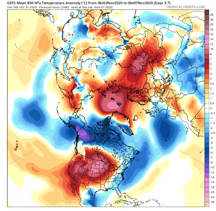
Europe – The temperature anomalies over the weekly average do indicate the colder air over western Europe. This is due to the passing of the cold front. But the passage will be rather fast and the warmer air will quickly expand back along with the higher pressure area. This cold front will be the main dynamic of the first week and will affect the British Isles, western Europe, Central Europe, but will lose power as it moves further towards eastern Europe.
North America – Here the pattern will be nicely separated north from south, by the amplified westerly flow we mentioned before. Alaska and northern Canada will be colder than normal, due to the low-pressure area dominating the region, transporting colder air from the polar regions. Further down, southern Canada and the United States will be mostly warmer than normal, as the high-pressure area will expand.
Some negative anomalies are seen over the eastern and southeastern United States, which is the colder air moving out, with the low-pressure system we mentioned earlier. Quite colder than normal airmass will transition over central and eastern United States in the first 3 days of November. But it will be quickly replaced by the warmer air from the southwest.
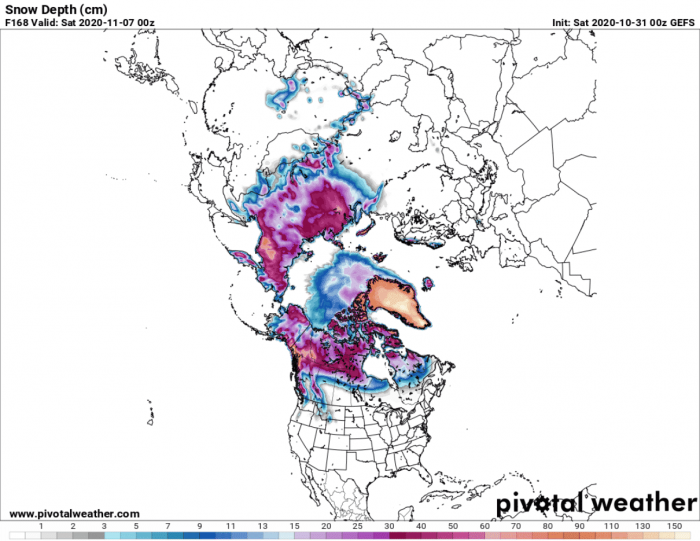
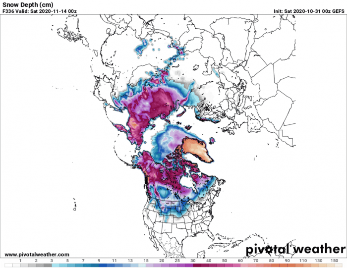
Snow Forecast – Looking at the snow depth forecast by the end of the first week of November, we can see quite a lack of snow cover over Europe and the United States. Despite the cold fronts, the warmer weather and higher pressure in the first week will not allow any significant snow cover advance over both continents.
Returning to the NAO index, we can see on the forecast that shows a more positive phase over the start of November. This means milder conditions over Europe, seen on the temperature image above. But the first week of November will see an exception to the rule, as the cold frontal transition will occur in the first days.
NOVEMBER WEATHER – WEEK 2
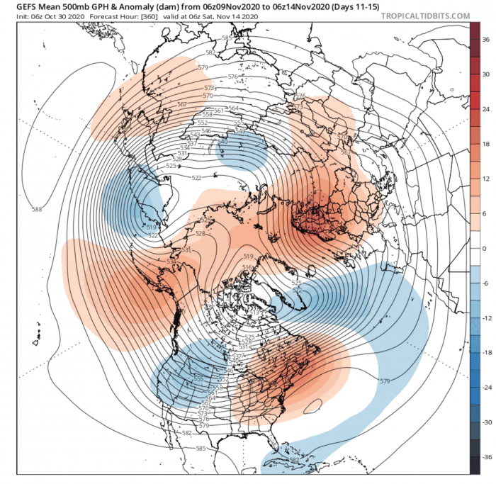
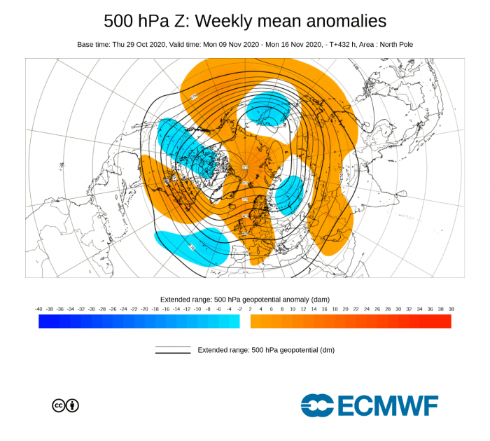
Into week 2 of November, the pattern will make quite a spin (no pun intended). The most significant takeaway is the high-pressure over Northern Pacific and Alaska and the Scandinavian high pressure.
Looking over Europe first, the high-pressure expanding behind the cold front in week 1, will strengthen and transition over northern Europe. The lowering pressure in the North Atlantic will help to strengthen the high-pressure system over Scandinavia, due to the warm southerly flow between the two systems.
Also, an interesting situation is over North America, where the key is the rising ridge over the North Pacific and Alaska. It will promote northerly flow over western Canada and the northwest United States. Effectively this will send a cold front down from Canada into the western and central United States. At the same time, the high-pressure system moves further east over the United States, along with the warmer weather and southerly airflow.
Europe – The pressure configuration that we have seen above, is quite straightforward for Europe. Lower pressure over the Atlantic and Higher pressure over Europe can only mean milder November weather for the continent.
But there is one caveat. As the higher pressure is located move over northern Europe, colder air transport is likely on the eastern side of the high-pressure block. There we can find northerly flow due to the clockwise rotation of the system. This means a possible drier cold front over eastern Europe, potentially reaching into parts of east/central Europe as well in the second half of week 2.
North America – Here we can see much more dynamic November weather development, as also more energy is involved. The temperature anomaly forecast on the image below reveals the colder air descending from the north, over Canada into the central and western United States.
Eastern parts are still seen warm, but since this is a weekly average, by the end of week 2, most of the northeast United States and eastern Canada will also be affected by the cold air outbreak. The exception will be southeastern parts of the United States, which will see fairly milder weather conditions, as the cold front moves over further north.
Snow Forecast – The snow depth forecast for week 2 shows an obvious expansion of snow cover over the north-central United States. But since this is an ensemble mean forecast, it does not show the full extent of the potential snow advance.
From this point, we will also be introducing the ECMWF extended ensemble forecast into the picture. It will add a new perspective to the forecast, helping to boost the confidence in the initial basic forecast by the GEFS model above.
The pressure pattern forecast for week 2 of November is fairly the same. We see the 4-wave pattern, meaning we have 4 main couples of pressure systems. One couple is a pair of high and low-pressure systems, and we can see 4 across the Northern Hemisphere. So this pretty much means that the scenario we described above has high confidence at this point.
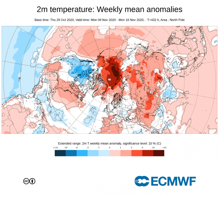
The surface temperature forecast also shows a similar scenario. Europe is mild, with hints of colder air over eastern and east/central Europe. North America also has colder air over western Canada and west/central United States, due to the advancing cold front from the north.
NOVEMBER WEATHER – WEEK 3
Going further into week 3, a new problem is introduced. As we use an ensemble forecasting system, it means that the final forecast is made out of several different/individual calculations. At short term forecasting up to 3 or 4 days, most if not all calculations show a fairly similar picture. Tho further into the future we go, the bigger is the difference between these calculations. That is also called the spread.
This just means that the forecast is showing weaker signals, as the calculated scenarios are getting very different with time. We can still look at the forecast to search for trends, but we need to understand that the spread is getting very big at this point. One way to mitigate this is to use different forecasting systems. That is why we introduced the ECMWF ensemble forecast in the previous week 2 segment. In weeks 3 and 4, we will be also adding the CFSv2 ensemble forecast. Combining the idea of 3 different ensemble systems, to see if any trends match and how confident they are.
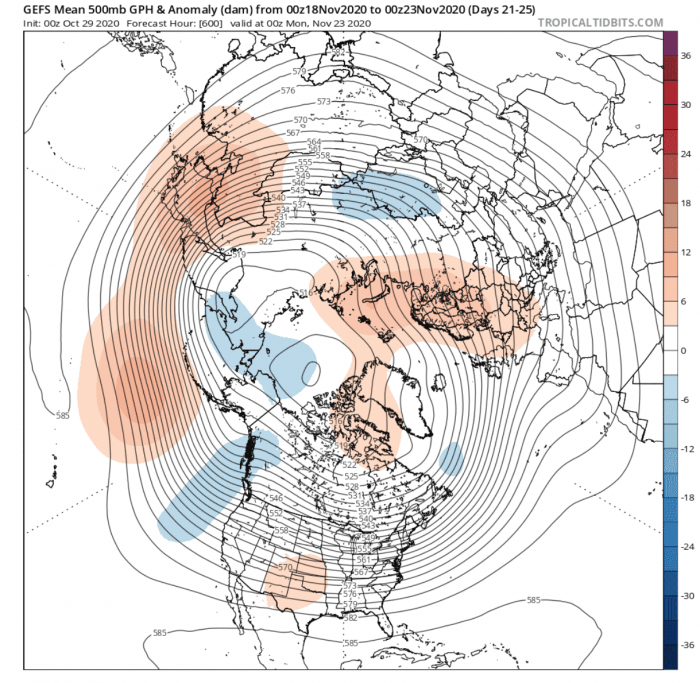
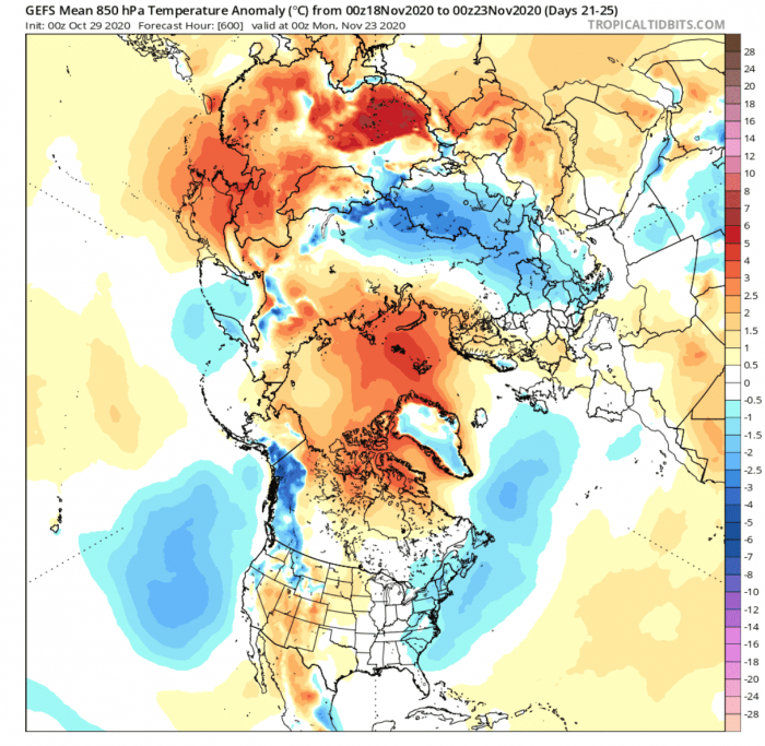
Week 3 is also where bigger differences will start to occur between different ensemble systems as well. First, looking at the GEFS it shows progression over North America, as the colder air outbreak moves further east over the United States and eastern Canada. Higher pressure starts building behind the outgoing cold air in the central parts of the United States. At the same time, we have a lower pressure are entering from the Pacific into the western United States and western Canada. This would further support the idea of higher pressure and warmer air building over the western and central parts.
Over Europe, the situation seems more stagnant, with the ongoing high pressure blocking over northern Europe.
Europe – With higher pressure that is indicated over northern Europe and lower pressure in the North Atlantic, it is safe to assume there is continued colder air transport into eastern Europe and parts of east/central Europe. As the higher pressure over Scandinavia is responsible for the colder air over the east, the lower pressure in the North Atlantic is usually associated with milder conditions over western and central Europe, also indicated on the week 3 temperature forecast image below.
North America – Over North America, we see the outgoing cold-air wave from week 2 over the United States and south/eastern Canada. West and the central United States are at this point seeing warmer than normal temperatures return with the building higher pressure system over the continental USA. Also helping with the warmer than normal air transport is the lower pressure on the west coast, which enables warmer southerly flow over parts of the western and central United States.
This is also the reason why we said that November will show two faces, as it will show two almost opposite weather patterns over both North America and Europe.
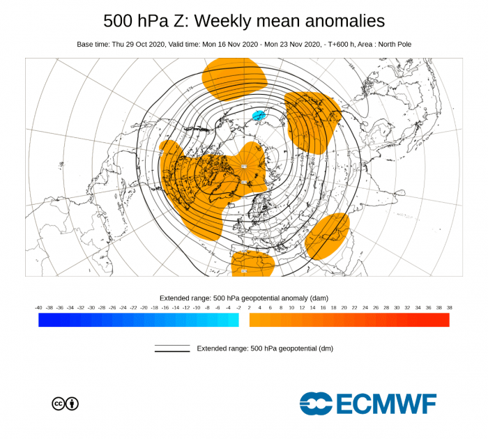
The week 3 pattern from ECMWF is fairly similar over North America. We see a tendency for lower pressure over the eastern Pacific and the west coast, extending towards Alaska. But a major difference is over the Euro-Atlantic sector, where we almost have an opposite situation. We see higher pressure located more towards the North Atlantic, with the Scandinavian blocking pretty much gone.
Temperature-wise, it means colder temperatures for western Europe and warmer for the eastern parts. Now this ECMWF forecast does not specifically show this, as the spread is too great at this range. But the colder air for northwestern Europe is indicated.
Over North America, we see no sign of colder than normal conditions over the eastern United States and Canada, and instead, we see warmer temperatures. That is due to a different pressure pattern over the Euro-Atlantic area we mentioned before, and the higher pressure over the North Atlantic and northeast Canada.
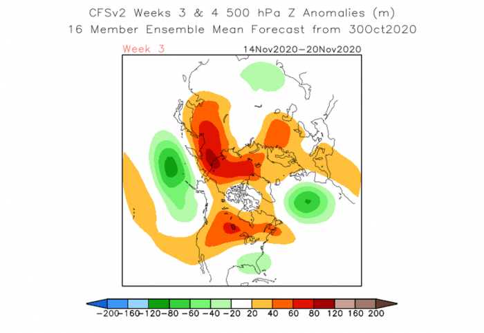
A new addition in week 3 is the CFSv2 ensemble system. Pattern wise, it shows a pretty similar Euro-Atlantic pattern as the GEFS, with the lower pressure in the Atlantic and higher pressure over northern Europe.
But over North America, the week 3 November weather pattern is unlike any of the previous two systems, as it features high pressure over the western United States and Canada and keeping the lower pressure from week 2 over the eastern parts. This is likely because this forecasting system is just slower with the pattern evolution. Between all the 3 forecasting systems featured in this article, the CFSv2 is the least reliable in most cases at this range due to its design. We will still include it, as a 3rd option and to see which scenario it supports more.
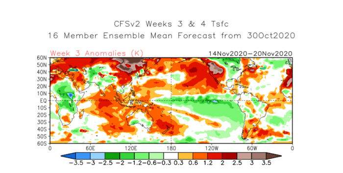
The week 3 temperature forecast from the CFSv2 is also showing much warmer than normal conditions over Eurasia, with only some hints of cooler conditions over the British Isles, from the cooler north Atlantic airmass.
NOVEMBER WEATHER – WEEK 4
At week 4, we see more progression over Europe, with the higher pressure finally gone from Scandinavia, and a new area of high pressure over western Europe. This is somewhat similar to the week 3 ECMWF forecast above, which indicates that there one model is just faster than the other, with an otherwise similar scenario. Such a pattern also suggests a likely scenario of a lower pressure area appearing now over northern Europe.
Over North America, we see a pretty similar situation as in week 3, with the high-pressure system now being more developed, reaching from the central United States up into eastern Canada. High pressure in the Pacific and low pressure over the west coast of North America remain in place. Some of this stationary pattern is due to the nature of ensemble forecasting, as so many different scenarios at this range can keep a certain average pattern in place.
Europe – Despite no low-pressure area is seen over northern Europe, the higher pressure over western Europe does tell the tale. A high-pressure area spins clockwise, meaning that it would promote northerly flow over Europe. The temperature forecast does show colder than normal temperatures over central and eastern Europe. Such a pattern would bring somewhat winter conditions over Europe if the cold air source zone from the north would be could enough at this point in time.
North America – No big change is seen over North America from week 3, as there are some hints of colder than normal weather over far eastern parts and the southeast United States, due to some northerly flow on the east side of the high-pressure area. Warmer than normal air is expanding from the southern United States up towards northern Canada, along with the area of higher pressure and the southerly flow from the low-pressure area out west. Tho at this point in time, the air temperatures up in northern Canada are very cold, despite the warmer anomalies. So the main focus is more on the United States and southern Canada, which are more on the edge between snowy winter conditions and milder weather, or even warm in the southern United States.
The November weather in week 4 is actually looking quite similar on the ECMWF forecast. We can actually see the low-pressure area over Scandinavia, and the same high-pressure area expanded from the central United States up into northern Canada.
The temperature forecast from ECMWF is indicating the warmer air expanding from the southern United States and shows the warmer than normal temperatures in northern Canada.
It does not show colder conditions over Europe, but that is because the confidence level is too low at this period. It means that colors (warmer/colder) are shown only where forecast confidence exceeds a certain threshold.
The CFSv2 also goes for the Western Europes high-pressure zone, and lower pressure over northwest Europe. But over North America, the situation is somewhat different, as it still keeps the low-pressure area over the eastern United States and a high-pressure zone over the western United States.
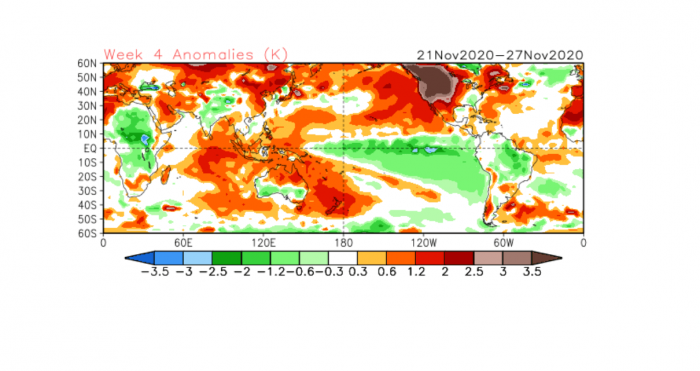
This is reflected in the temperature forecast. Over Europe, it shows mostly above-normal temperatures, because the source airmass is from the Atlantic and not from the north. That is because of the low-pressure area being over northwest Europe instead of Scandinavia.
Over North America, the CFSv2 shows unusually warm temperatures over the western United States and Canada, which goes against both the GEFS and the ECMWF.
DECEMBER TREND AND WINTER START
Early December is quite far off, so we will only be looking at the ECMWF trends. This is to be taken with a lot of reserves, since it is the far extended range by this point.
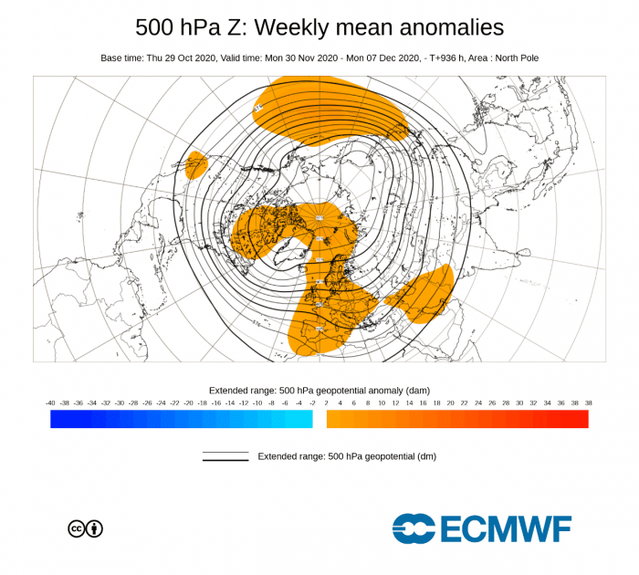
In the first week of December, ECMWF shows the persistent North Pacific high-pressure area. This is a very important key player since it is expected to form and stay there over Winter. It is a typical feature for a La Nina winter pattern. This means that a low-pressure area is likely over Western Canada, bending the polar jet stream and bringing cooler/colder weather to parts of the western and northern United States.
We do not see any low-pressure area in the forecast image below, but that is just due to the large spread and lower confidence. Over Europe, we see a high-pressure one is indicated over western and parts of central Europe.
Temperature-wise, we do not see any colder than normal conditions over western Canada and the United States, but that is again due to the low confidence in the forecast. The white area over western Canada and the United States and warmer than normal temperatures towards eastern parts suggest such a pattern with colder temperatures over western parts of North America.
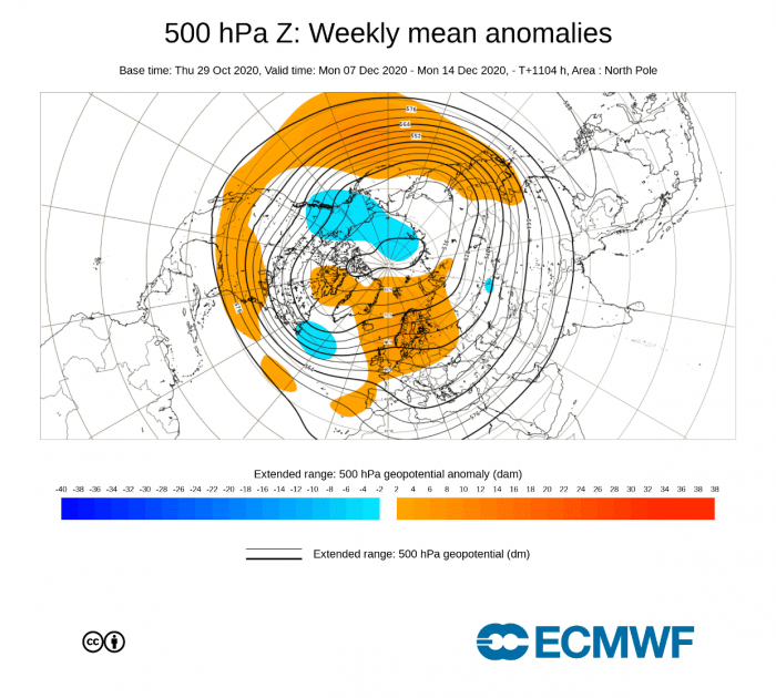
But, week 2 of December now does show the low-pressure zone over western Canada, as mentioned before being an integral part of the La Nina winter pattern.
Over Europe, we see the high-pressure area rising towards the North, which could again make room for some colder air movement from the north into parts of eastern/central Europe.
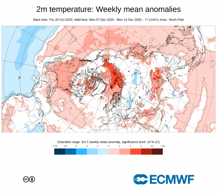
Temperature forecast suggests warmer than normal temperatures over much of western and central United States, due to the amplification of the pattern and a more westerly flow. But there is an important factor at play here. A low-pressure area over western Canada can release colder air into the western United States and further towards the midwest. So this forecast is just an average of different scenarios, of which only 1 will be correct in the end. A very high probability exists at this point, for colder weather in the western United States and towards the east based on the pattern, not the temperature forecast.
We can see over Europe, that some normal-to-colder air is indicated towards the east, despite the large spread and low confidence at this forecast range. It is quite likely that if such a pattern were to materialize, the colder air would reach further into central Europe.
NOVEMBER WEATHER AND THE POLAR VORTEX
One aspect of the November weather development is the stratospheric polar vortex. A lot has been already written about the Polar Vortex and its winter influence.
Essentially, the polar vortex is a large area of cyclonic circulation high above the Northern Hemisphere. It extends all the way from the ground, up into the stratosphere, over 40km altitude.
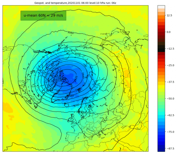
We tend to look at the stratospheric polar vortex and its development because when it is strong, it can also influence the lower layers of the atmosphere and our weather. Usually, a strong polar vortex corresponds to lower pressure in the North Atlantic and over the North Pole. That can mean a stronger jet stream and the cold air tends to be locked into the polar region. So a strong polar vortex is not what one wants to see if you hope for a colder and snowier winter over Europe and the United States.
Current forecast show quite intense strengthening of the polar vortex. The first image shows the conditions at the beginning of November. Comparing to the second image from the middle of the month, we can see how much has the polar vortex cooled and expanded in just two weeks. Images are by weatheriscool.com.
The most common way to estimate the strength of the stratospheric polar vortex is to look at the wind speeds it produces. We usually look at the strength of the stratospheric jet stream at 10mb level (~30km altitude) in the middle stratosphere.
The image below from the excellent polar vortex page by Simon Lee, shows the average strength of the westerly winds at that level, around the polar circle (60°N latitude).
We can see the stratospheric winds are running above the long term average, reaching near-record levels by early December. This indicates a strong polar vortex. But despite being very strong, it can sometimes still be disconnected from the lower layers of the atmosphere, meaning it does not have such a strong influence.
Essentially, the pressure pattern which we look at earlier can deflect the influence of a strong polar vortex. That can especially be the case in situations with strong global forcings, like the strong La Nina this year. So a strong polar vortex does not always indicate a mild or weak start of the winter.
We produced a high-resolution video, which nicely shows the growth and expansion of the stratospheric polar vortex. It shows the growth and cooling over a two week period. It is very obvious how the polar vortex gets colder and expands, increasing its strength and influence.
We will also be releasing a brand new and final Winter 2020/2021 forecast, based on the latest model calculation and developing long term trend, so stay tuned!
In the meantime you can check the last Winter 2020/2021 forecast, based on October model data:
Winter 2020/2021 early forecast (October 2020)
ALSO DONT MISS:
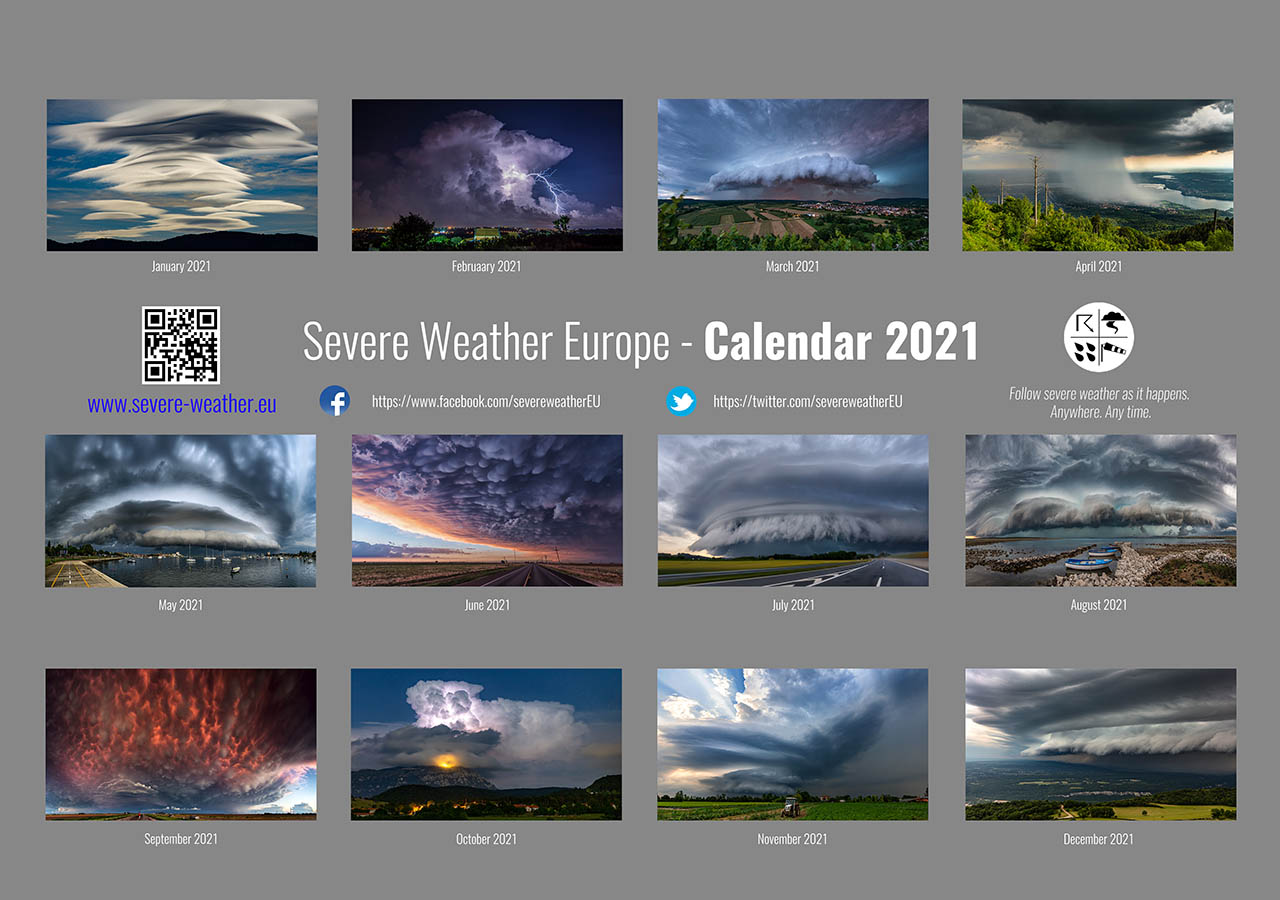
Thinking of a nice Christmas gift for your friends, family or someone special to you? Weather calendar could be the perfect gift for them – see below:

