The latest forecast data shows a developing disruption around the stratospheric Polar Vortex in the coming days. Strong pressure anomalies will change the shape of the Polar Vortex, effectively creating the first major cold air outbreak of the season across Canada and the United States.
Weather and the stratospheric Polar Vortex are strongly connected, especially in the cold weather season. For this reason, we closely monitor the state of the Polar Vortex.
We will look at the latest analysis of the stratospheric anomalies and how the disruption event will help bring a cold air outbreak into Canada and the United States in the final days of this month.

POLAR VORTEX OF THE NORTH
To understand what the Polar Vortex is, we can try and visualize it. In simple terms, it is just a name that describes the broad winter circulation over the northern (and southern) hemispheres.
Below, you can see a 3-dimensional image of the Polar Vortex. The vertical axis is greatly enhanced for better visual presentation. It basically shows the actual structure of the Polar Vortex, connecting down to the lower levels and to the pressure systems.
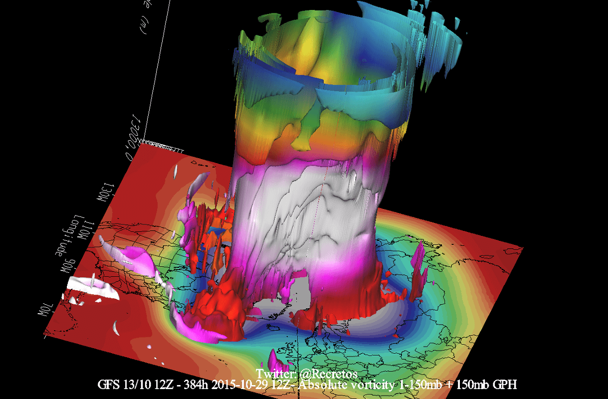
The Polar Vortex extends high up into the atmosphere. The lowest level of the atmosphere is called the troposphere, where all the weather events are. But above that, we have the Stratosphere, a deeper and drier layer and the home of the ozone layer.
For this reason, we tend to separate the entire Polar Vortex into an upper (stratospheric) and a lower (tropospheric) part. They both play their role differently, so we monitor them separately. But it is also very important if they are properly connected—image by NOAA-Climate.
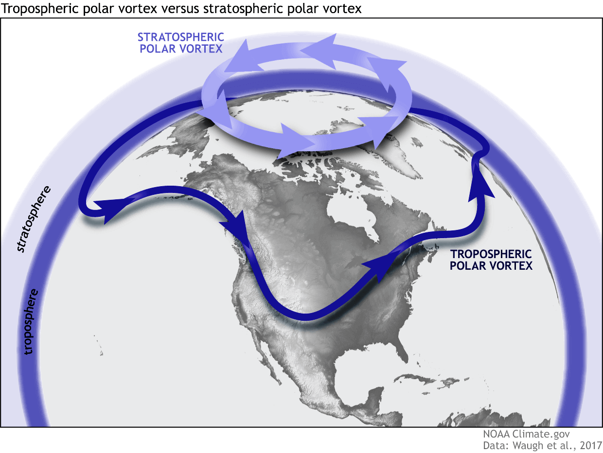
The upper (stratospheric) part is more circular and symmetrical as it spins higher above the ground, with fewer obstacles in its flow.
But, the lower structure of the Polar Vortex is much more uneven and regularly disrupted. That is due to the influence of the terrain/mountains and strong pressure systems acting as obstacles.
The Polar Vortex behaves like a very large cyclone, covering the whole north pole down to the mid-latitudes. It is connected through all atmospheric levels, from the ground up, but can have different shapes at different altitudes.
To put the Polar Vortex into perspective, we produced a high-resolution video below, showing the Vortex spinning over the Northern Hemisphere in the Stratosphere at the 30mb level, around 23km/14miles altitude.
The video mainly shows that the Polar Vortex is not just one winter storm or a cold outbreak that moves from the Midwest into the northeastern United States. It is a powerful large-scale circulation.
It is very important that we monitor the state of the Polar Vortex, as it can have a profound impact on our daily weather. We mainly separate the Polar Vortex into two different modes:
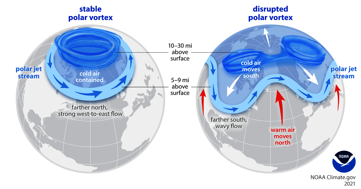
A strong/stable Polar Vortex usually means strong polar circulation and jet stream. This contains the colder air into the Arctic Circle, creating milder conditions for most of the United States.
In contrast, a weak/disrupted Polar Vortex creates a weak jet stream pattern. As a result, it has a harder time containing the cold air, which can now escape from the polar regions into the United States. Image by NOAA.

So, if you want a colder and snowier Winter, your odds are highest with a weak Polar Vortex. In nature, a weak Polar Vortex essentially means a breakdown of the stratospheric Polar Vortex.
That is usually achieved by increasing the pressure or temperature in the polar Stratosphere. We call such events “Sudden Stratospheric Warming”. As the name suggests, it is a rapid temperature increase in the Stratosphere.
But not every disruption event is a major Stratospheric Warming event. As you will see, even smaller disruptions can influence the Polar Vortex and the weather at the surface.
CURRENT STATE OF THE POLAR VORTEX
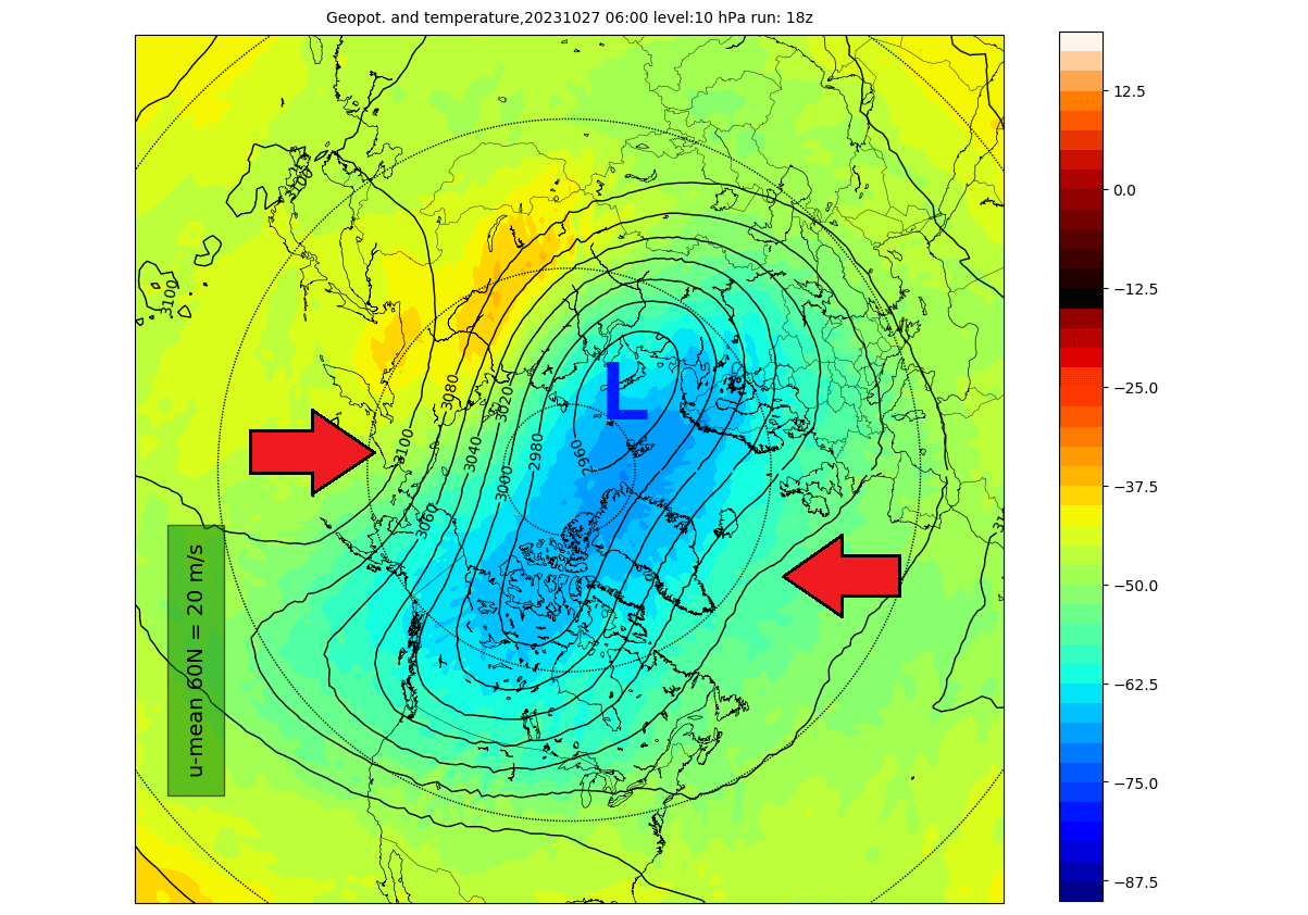
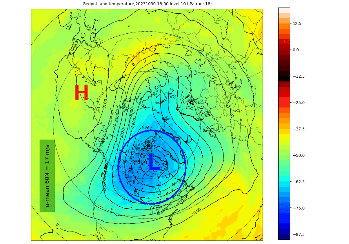
The Polar Vortex is currently normal in size and has a growing cold core over the polar regions. The image below shows geopotential height and temperature in the mid-stratosphere at the 10mb level (30km/18.5miles). The Polar Vortex looks like a “cyclone” with a cold core near its low-pressure center.
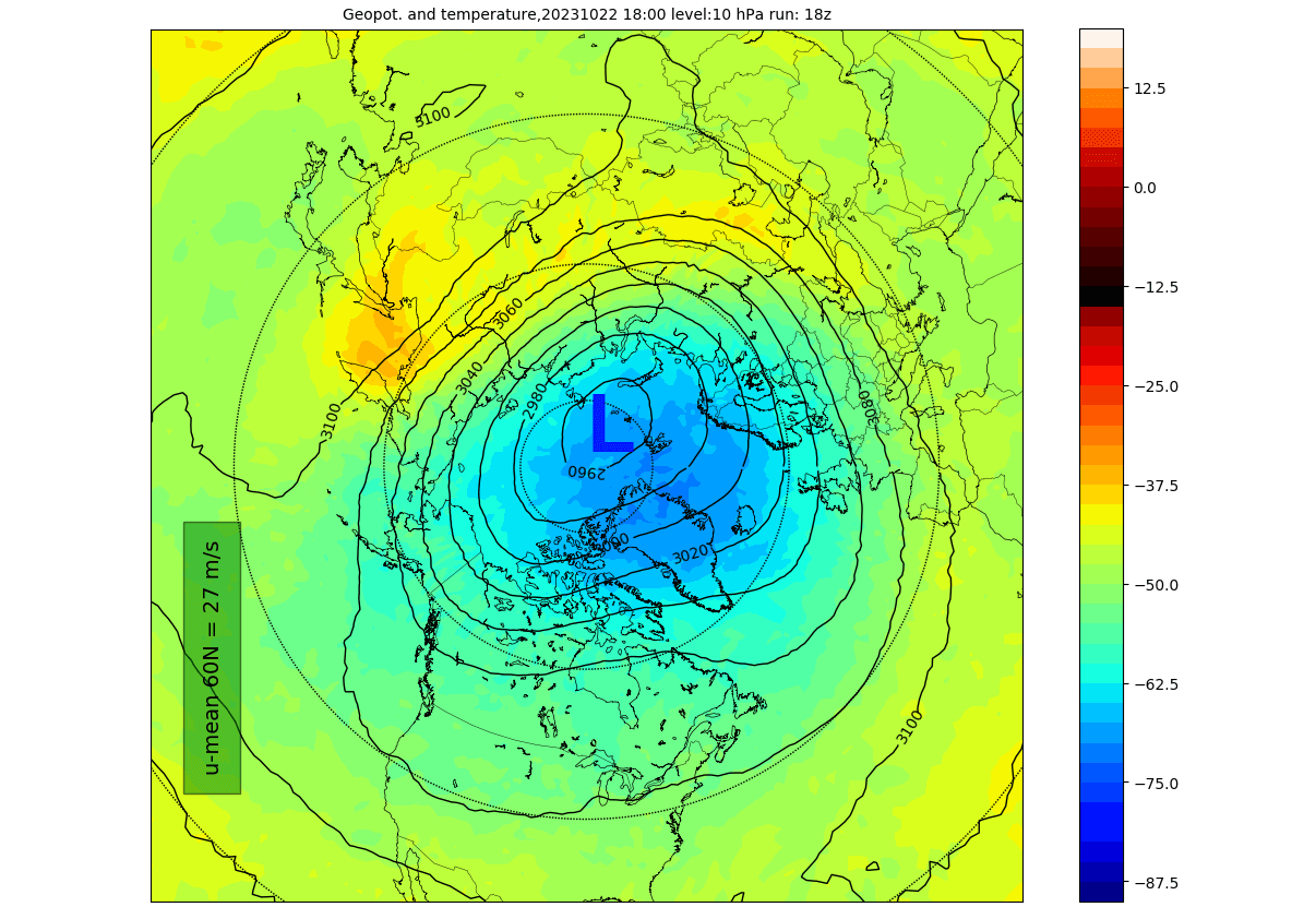
The image above is by weatheriscool.com
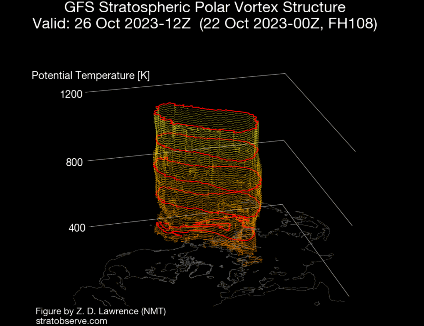
If we look at the 3D structure, we can fully see the current compact structure of the Polar Vortex. It is nicely organized and circular in shape. An organized/circular shape usually indicates that the Polar Vortex is strong.

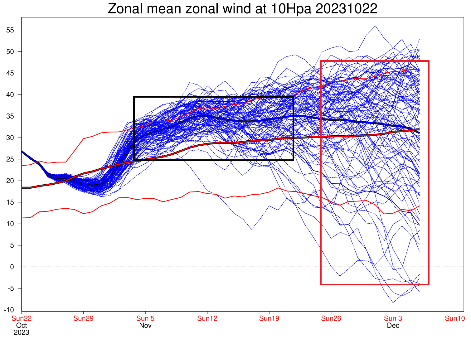
But how do we measure the strength of the stratospheric Polar Vortex? The simple answer is the winds. More specifically, the stratospheric polar jet. The more organized the stratospheric polar Vortex is, the stronger the winds inside it.
The image below shows the wind forecast for the polar Vortex in the mid-stratosphere. The blue square is the current state. You can see that the polar Vortex is currently stronger than normal. We already saw hints of that by looking at its shape and 3D structure.
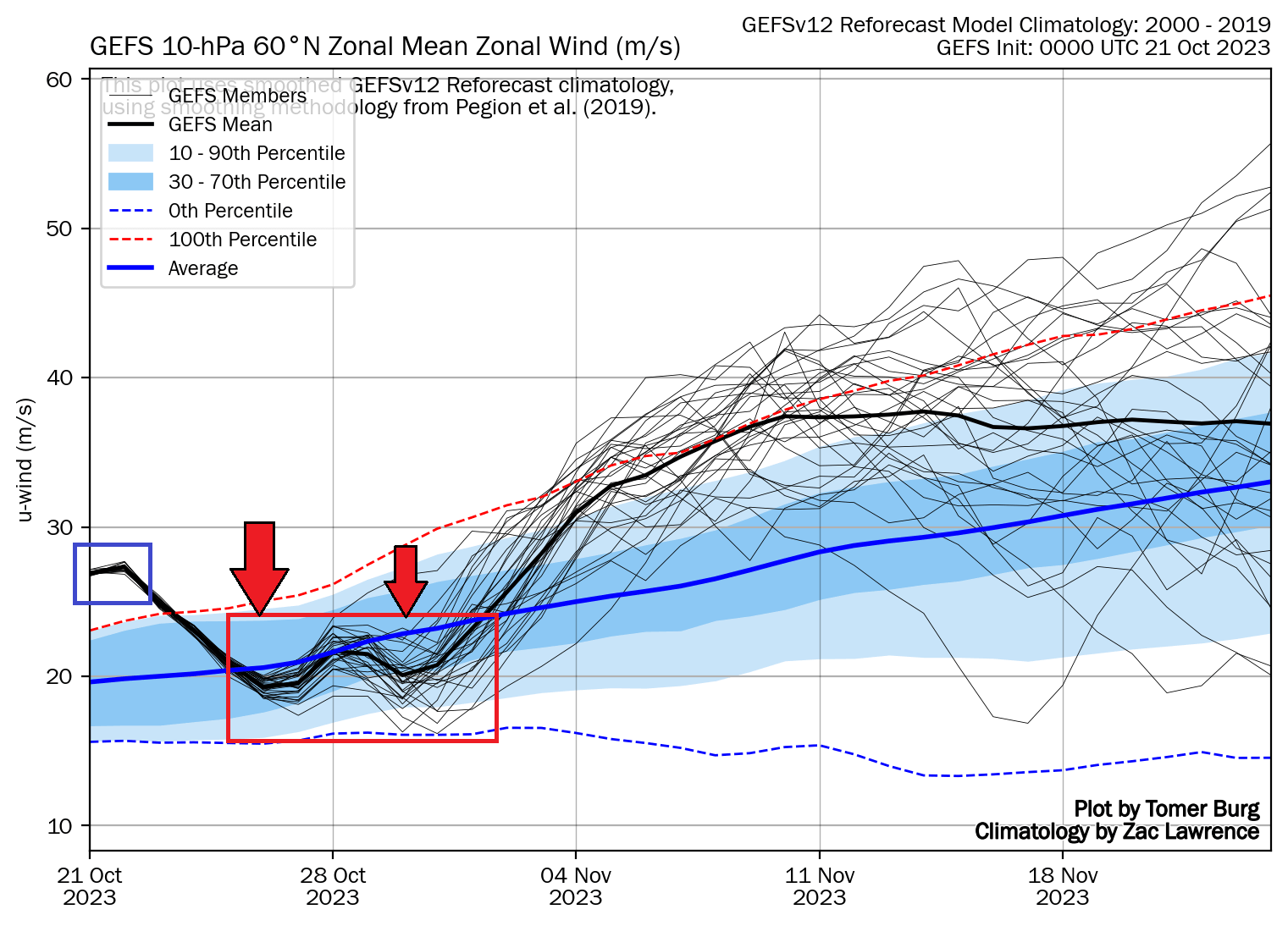
But, notice a decent wind deceleration coming later in the month. That is a substantial weakening for this time of year. But how does such an abrupt weakening of the Polar Vortex even happen? We will look more closely at this event and how it will connect to our daily weather.
ABOVE AND BELOW IN THE ATMOSPHERE
Polar Vortex disruption usually comes from below. It is from the direct influence of strong pressure systems, having an impact upwards into the Stratosphere. Pairs of pressure systems are also known as Rossby Waves. You can see an example of Rossby waves in the image below by NOAA.
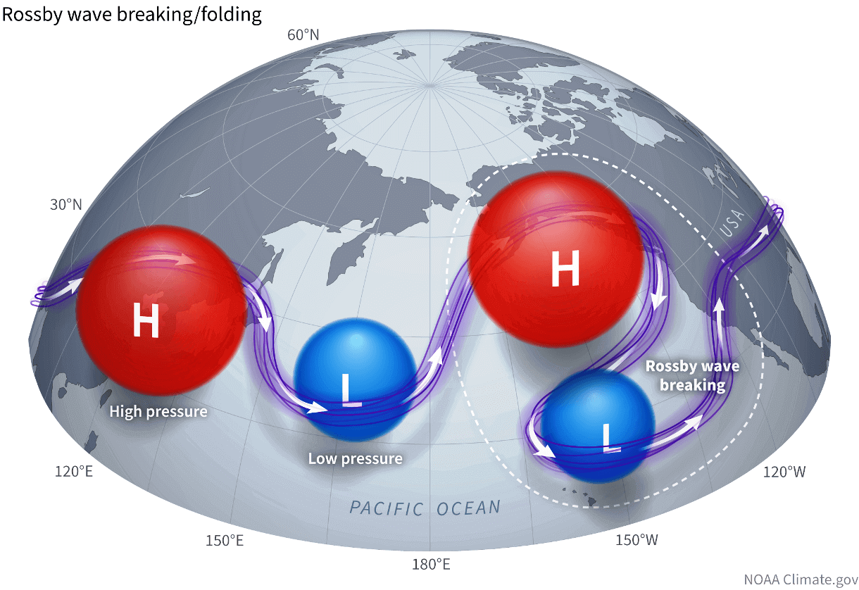
Rossby Waves (a pair of strong high and low-pressure systems) deflect energy upwards into the Stratosphere as they break. That energy can deform the Polar Vortex, temporarily pausing its strengthening or weakening its circulation.
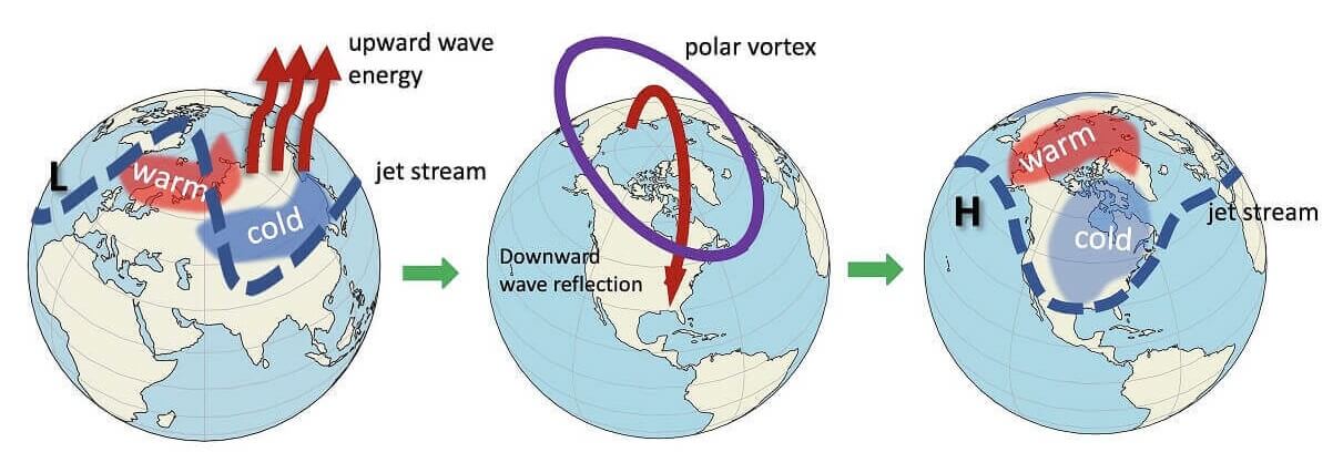
In the image below, you can see the vertical wave activity example. First, the energy goes into the Stratosphere, which impacts the Polar Vortex and later affects the polar circulation back down, changing the weather patterns as the Polar Vortex is disrupted.
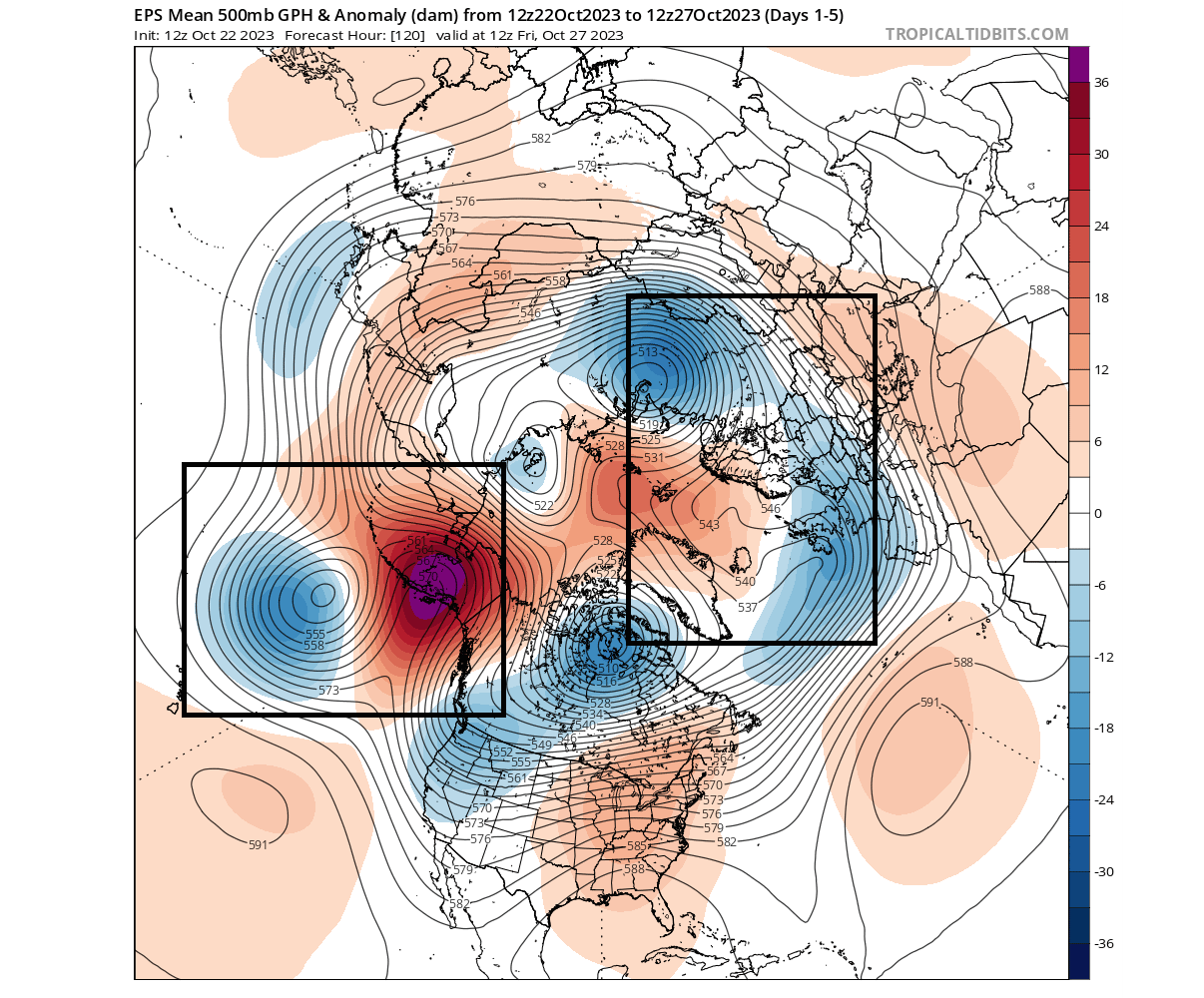
We can see the Rossby waves in the 5-day pressure forecast below. Notice the two marked zones with pairs of strong high and low-pressure regions. This setup enables the “wave breaking,” sending energy upwards into the Stratosphere and disrupting the Polar Vortex dynamics.
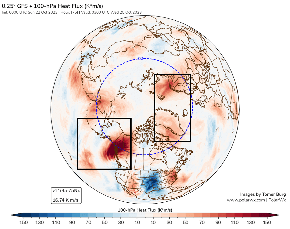
For that purpose, we have a special graphic from Tomer Burg. Below, you can see the 100mb heat flux chart. It shows the temperature transport on the border from the troposphere to the Stratosphere. Again, you can see strong regions with positive upward heat/energy transfer in the main Rossby wave-breaking activity area.
All this shows us that the strong pressure patterns in the lower levels can reflect a lot of energy upwards into the stratospheric Polar Vortex. We will now look at how the Polar Vortex is actually going to respond to these dynamics from below.
POLAR VORTEX UNDER PRESSURE
Looking at the forecast for later in the week, you can see in the forecast below where that energy manifests in the middle levels. The stratospheric Polar Vortex will get pressed from both sides, courtesy of the Rossby wave-breaking events. This is similar to squeezing a balloon with both hands, it gets deformed.
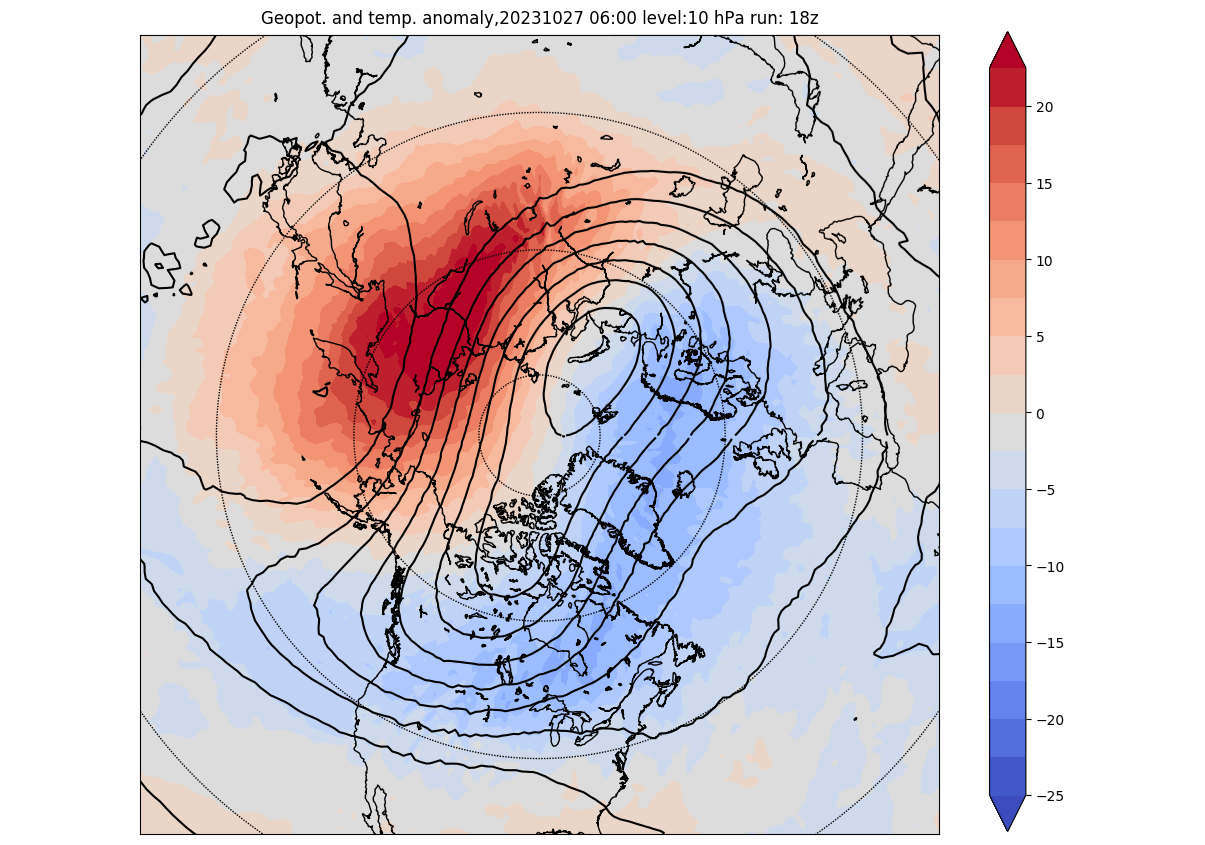
The temperature anomaly forecast for the same period also shows higher-than-usual temperatures emerging over the Siberian region. That works in tandem with a higher-pressure zone emerging over the North Pacific and compressing the Polar Vortex.
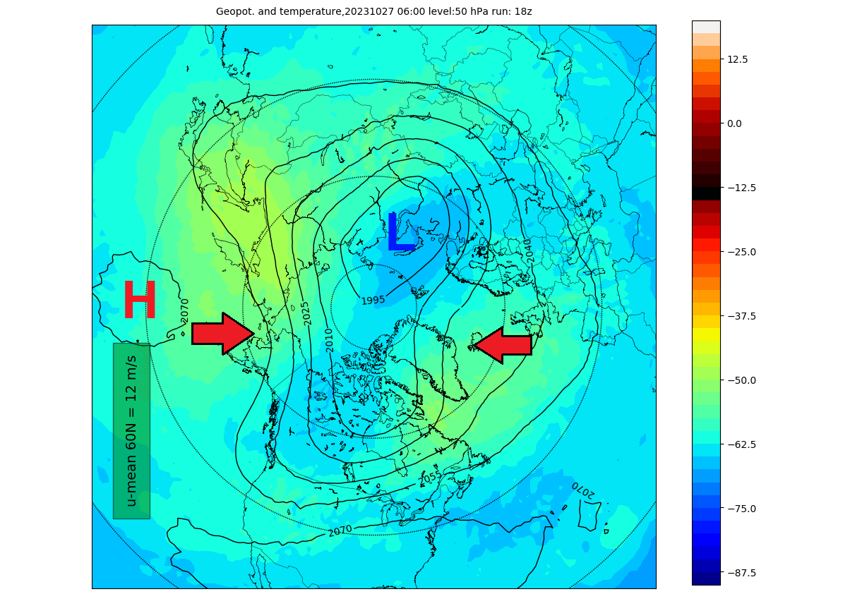
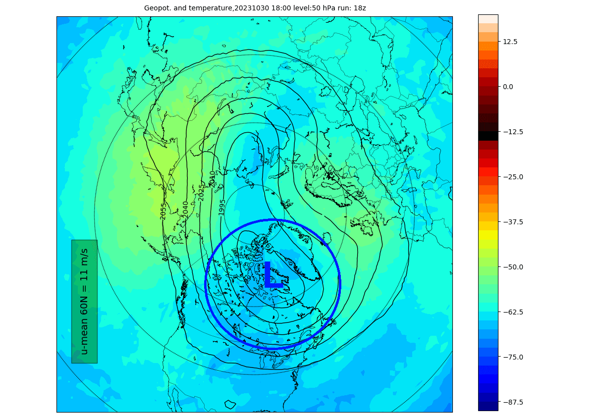
Below is a forecast for the 50mb pressure level in the Stratosphere at around 20km/12.5 miles altitude. Even lower in the Stratosphere, the Polar Vortex is compressed, with the main core sitting over the Polar regions.
You can see the whole event even better on the vertical 3D structure. The Polar Vortex is forecast to shift from a perfect circular shape to an elongated/deformed one. Being pressed from two sides, it is forecast to turn into a more oval shape, also seen in the forecast images above.
So what is the further progression of this event and the surface weather impacts?
WHEN WEATHER PATTERNS CHANGE
The evolution in the Stratosphere is quite straightforward. Going into next week, the Polar Vortex will remain compressed. But the big change is that the core of the Polar Vortex itself will position over Canada and the northern United States.
Lower down in the Stratosphere, you can see the same process, with the Polar Vortex core positioning over Canada. This shows a strong overall connection through all the layers of the atmosphere.
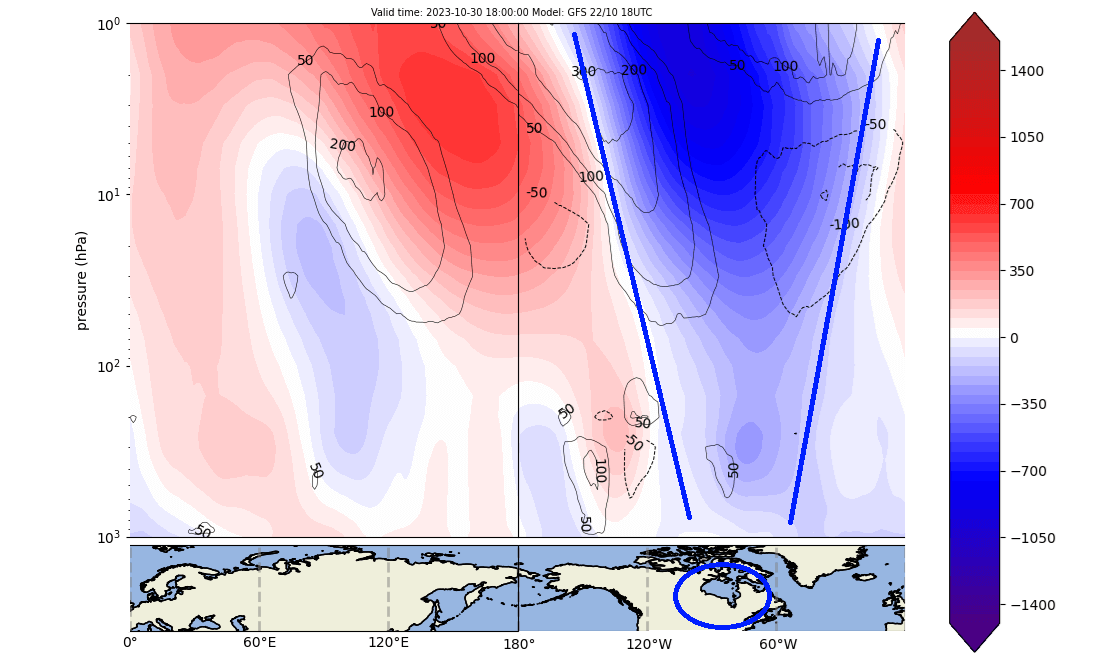
The vertical pressure anomaly structure is getting more important at this point. It can show connections points and changes in the pressure patterns.
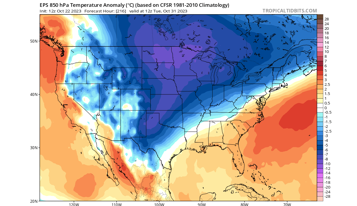
The forecast below shows the vertical pressure anomalies for the same period. You can see the strong negative anomalies directly over Canada and the United States, connecting down from the Stratosphere. This is the actual core of the Polar Vortex.
You can see this if we look at the pressure pattern in the lower levels. Notice the broad low-pressure area over Canada and the United States. This is the main connection to the stratospheric Polar Vortex, as far as pure anomalies go. This is a strong low-pressure system directly connected to the stratospheric Polar Vortex.
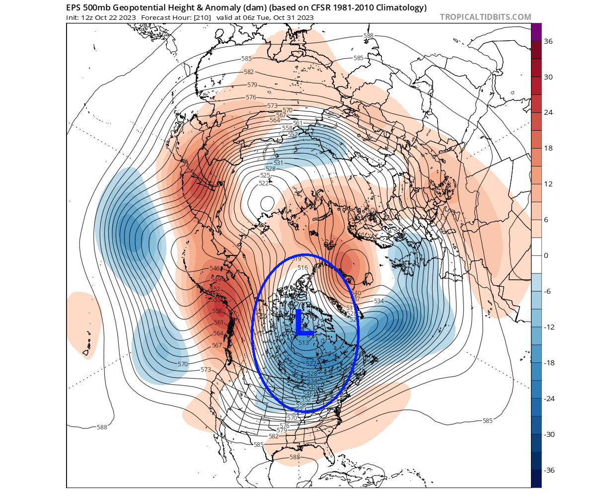
The vertical 3D structure reveals the continued elongated shape in this time period. But notice the broader area over North America, which is the relocated core of the Polar Vortex.

If you look closely at the Polar Vortex above, it has the same shape as a disrupted Polar Vortex example in the NOAA Climate graphic. This unlocks the arctic doors, allowing the cold air to move south into Canada and the United States.
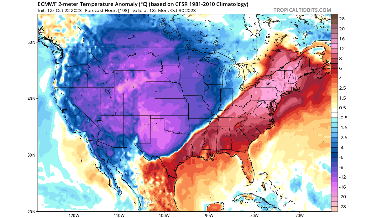
Looking at the temperature forecast for early next week, you can see the cold air engulfing much of Canada and the United States. This is because the lower Polar Vortex core area sits over the northeastern United States and northern Canada. That enables an unseasonably cold air flow down into the United States.
We will take a quick look at this cold air outbreak on a surface level. As the event gets closer, we will issue a more detailed forecast of the cold anomalies across southern Canada and the United States.
COLD AIR OUTBREAK
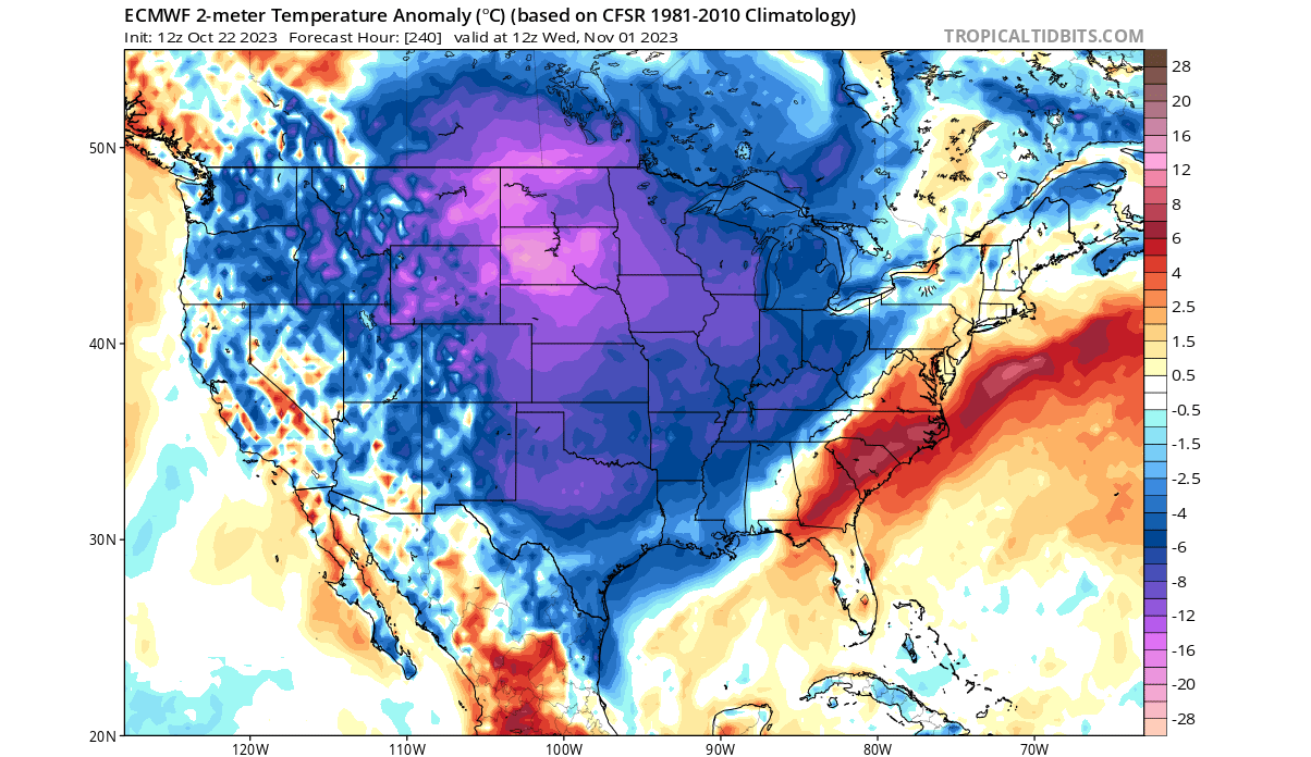
Looking at early next week, the cold air outbreak will begin with strong cold anomalies and unseasonably cold temperatures spreading from the north. The cold air outbreak will first cover much of the western and northern United States, the plains, and the Midwest.
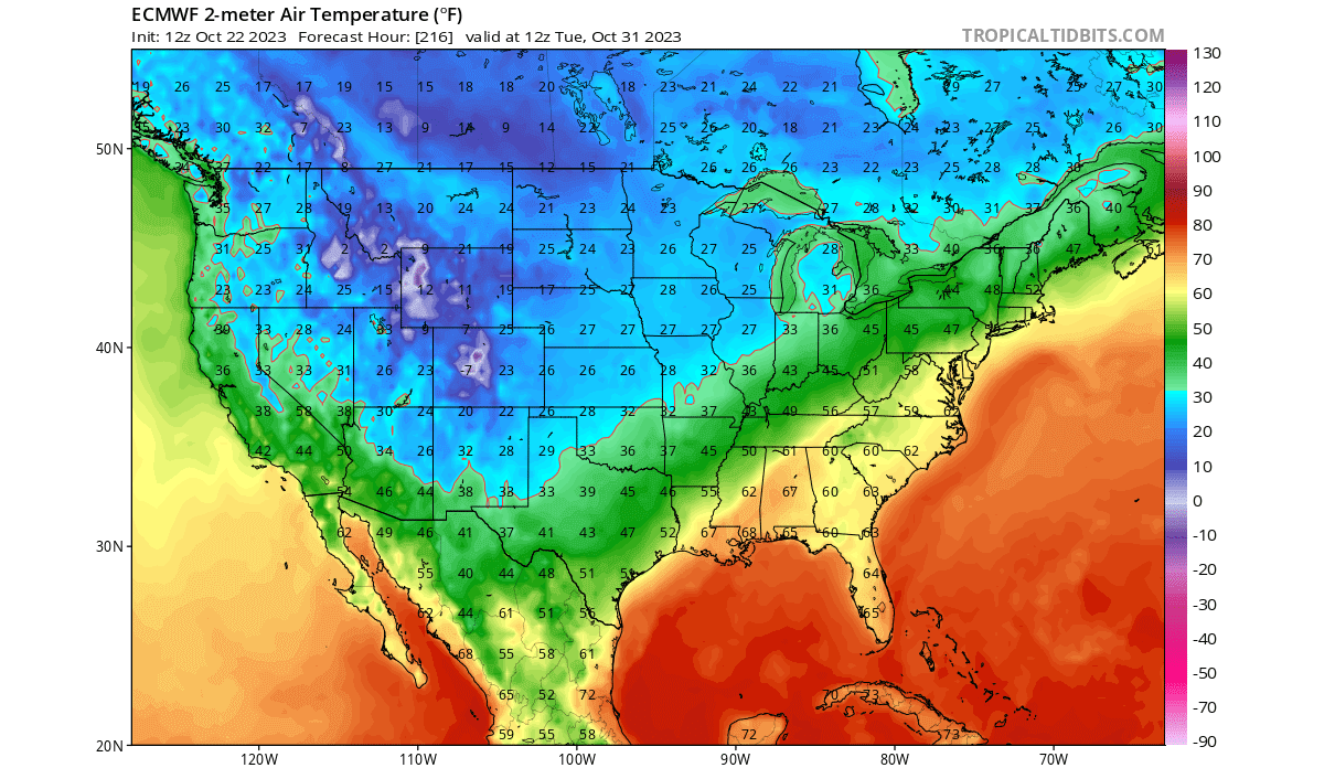
The image below shows the morning temperature forecast for next Tuesday. You can see temperatures at the freezing level or lower across a wide area of the United States, reaching from the northern United States into the Midwest and down across the Plains.
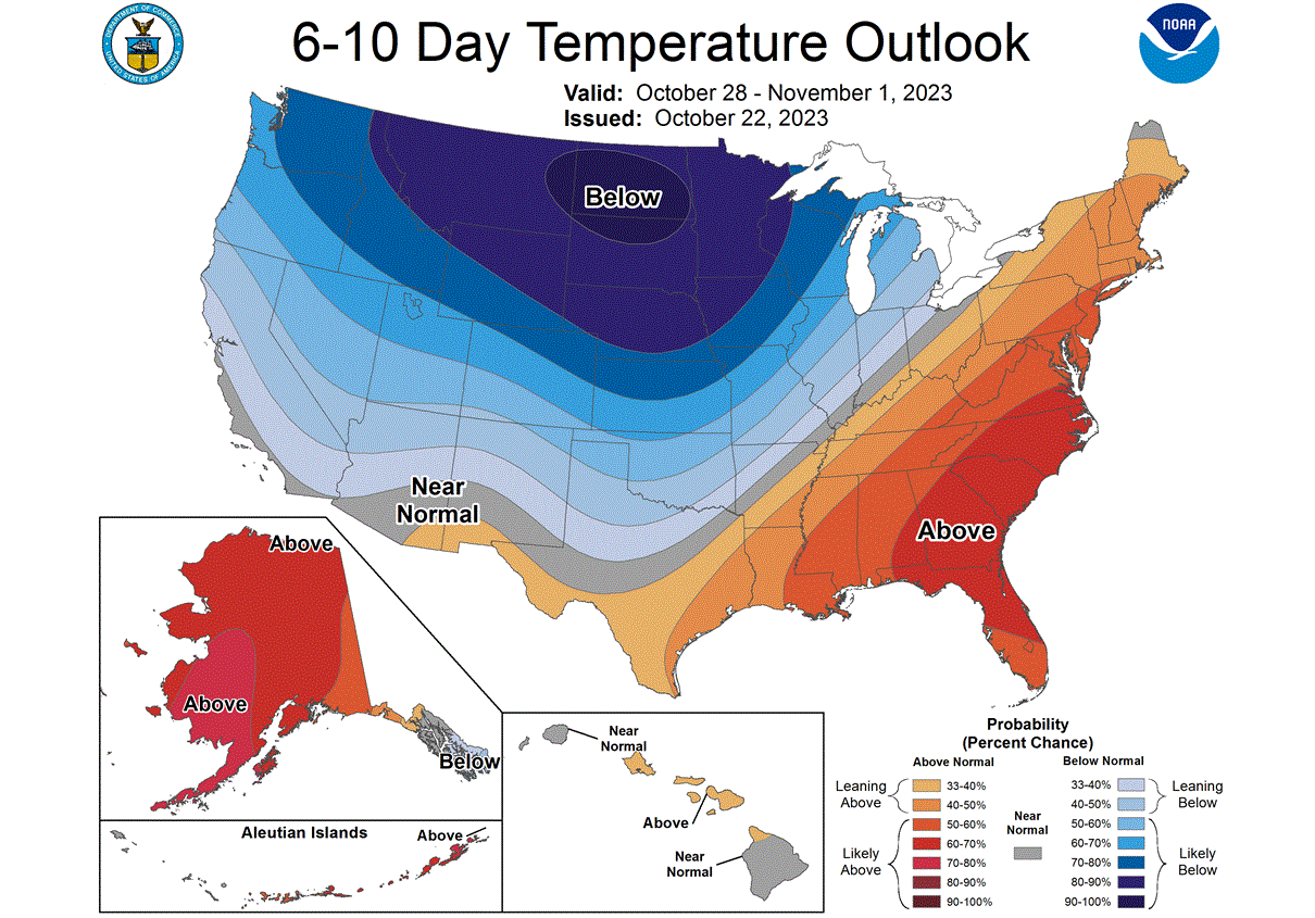
The NOAA official temperature forecast for 6-10 days ahead also shows the massive cold air anomaly spreading from the north. Warmer than normal temperatures will prevail over the eastern United States but are expected to move out as the cold wave progresses south and east over the week.
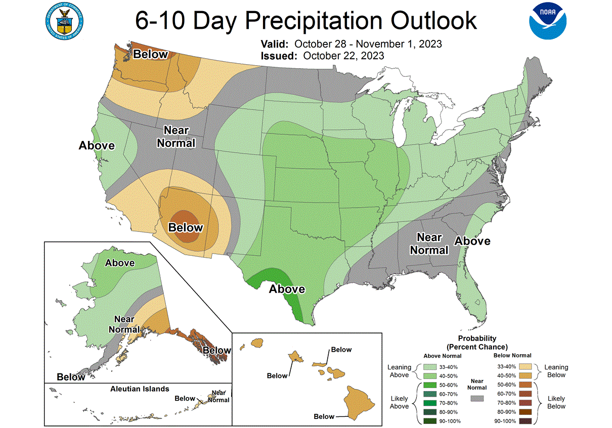
The official precipitation forecast for the 6-10 day range shows more precipitation from the southern United States, up across the plains, the Midwest, and into the Northeast. The highest snowfall potential is across the northern United States, northern Plains, and the upper Midwest.
Going into mid-next week, the cold air will move further east. The warm anomalies across the eastern United will diminish as the cold wave reaches into the southern United States and moves further east.
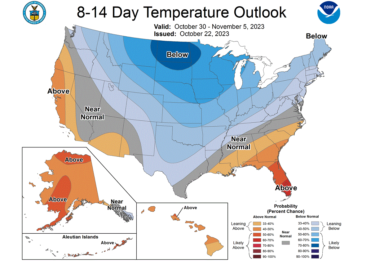
The official 8-14 temperature outlook shows the progression of the colder air into the southern and eastern United States, especially the Northeast. Warmer temperatures are expected to remain in the deep southeast and southwestern parts of the United States.
The latest model forecast shows snowfall across the mentioned area, with the main focus for snowfall potential being across the northern United States and the Central Plains.

After this cold outbreak event, what is next in store for the Polar Vortex?
POLAR VORTEX EXTENDED FORECAST
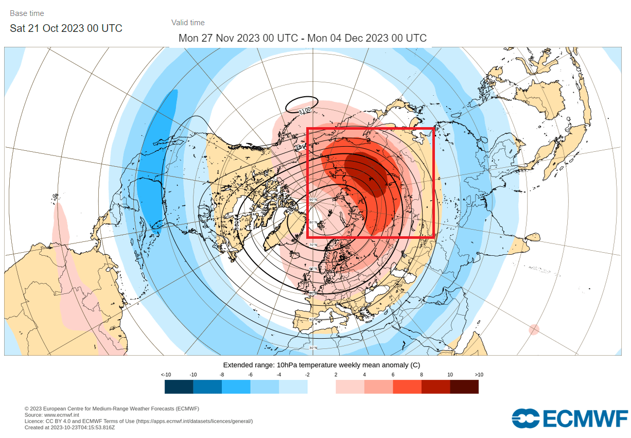
Looking at the ECMWF ensemble forecast, you can see that the Polar Vortex will regenerate in the first half of November. It is too early to talk about surface weather at this point. But looking into late month and early December, the ensemble spread is large.
Some of the forecast scenarios do show another round of weakening, even substantial ones.
The forecast image below is the ensemble average for late November and early December. The ECMWF actually shows a stratospheric warming anomaly. This is an interesting scenario and would mean an increased potential for another disruption later in the month.
This whole event is driven by large-scale processes, from the lower levels to the high levels of the Stratosphere. This nicely shows why monitoring the Polar Vortex activity and how it connects with our everyday weather is important.
As we enter Winter, the chances for a stronger disruption event in the Stratosphere increase. It is possible to have a full-scale Sudden Stratospheric Warming (SSW) event, which can mean a full collapse and reverse of the polar circulation.
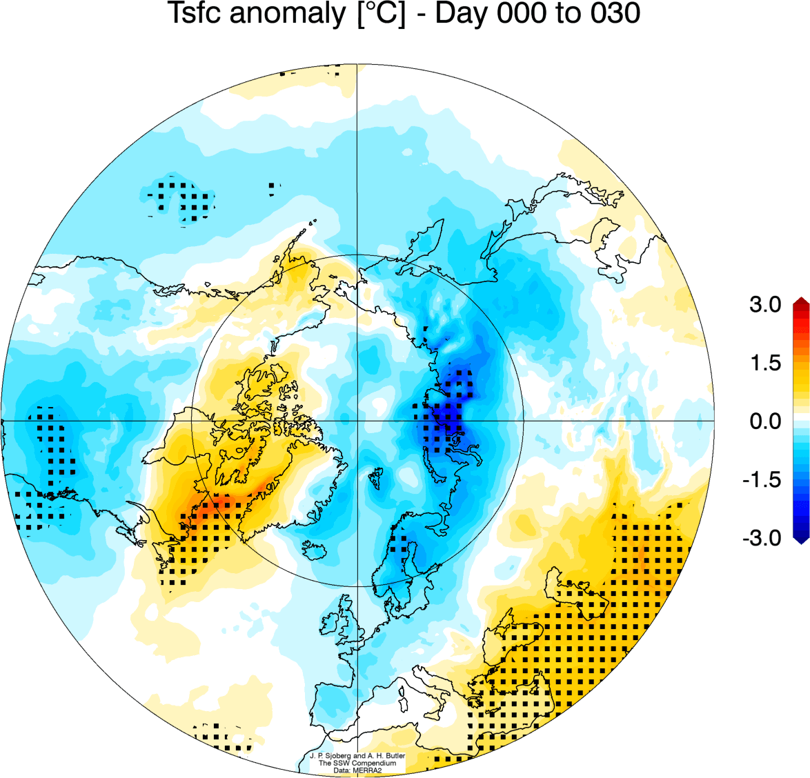
The average temperature of 0-30 days after a Sudden Stratospheric Warming event shows that most of the United States is typically colder than normal. Note: this is an average picture of many SSW events. Each stratospheric warming event is different and does not automatically mean a strong winter pattern.
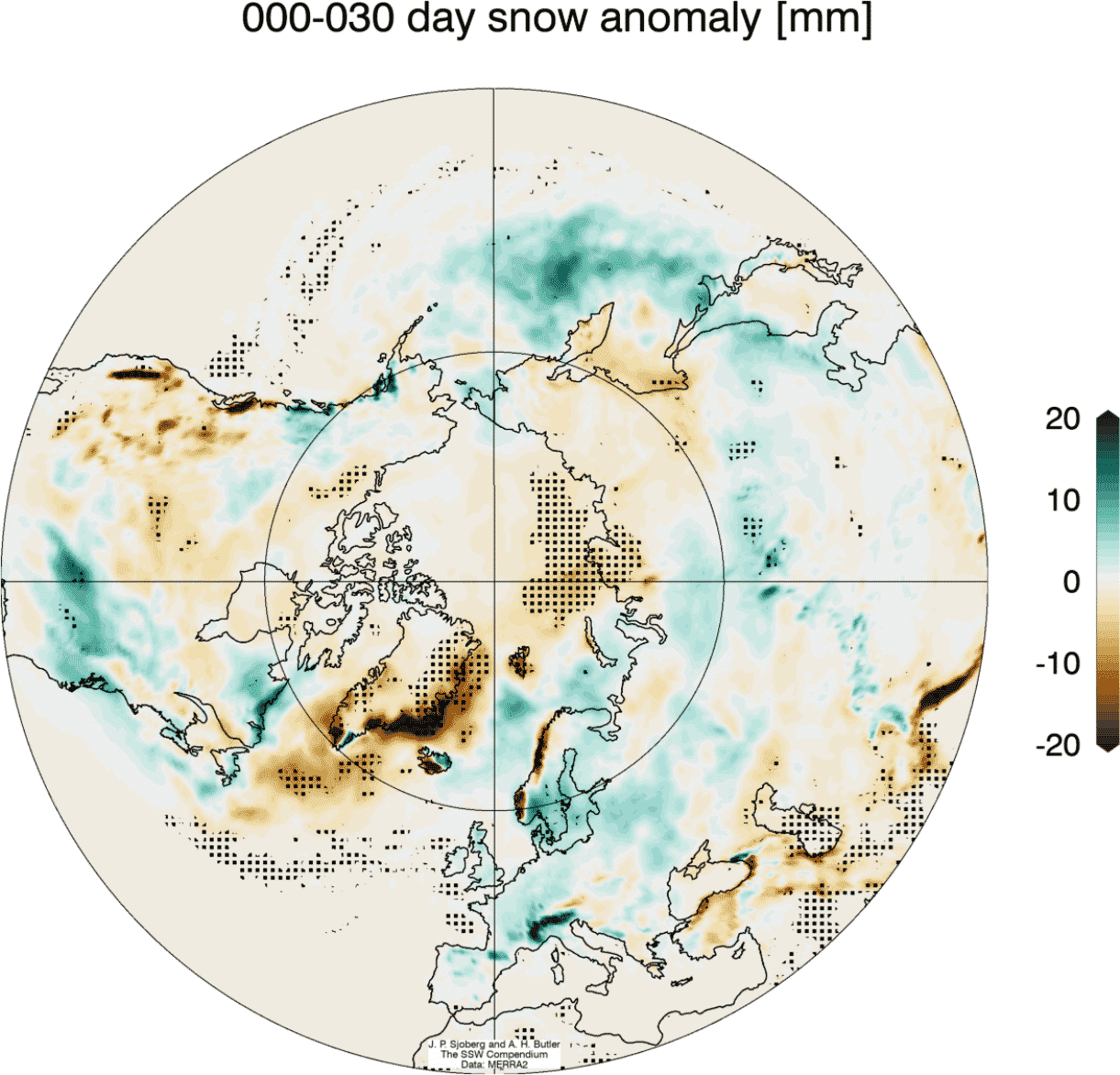
Looking at the snowfall below, we can see above-average snowfall over much of the eastern United States. Again, this is an expected response, as typically, after major stratospheric warming, the colder air has an easier path towards the south and into these regions.
We will keep you updated on the global weather pattern development, so bookmark our page. Also, if you have seen this article in the Google App (Discover) feed, click the like button (♥) there to see more of our forecasts and our latest articles on weather and nature in general.
Don’t miss: